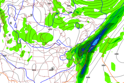
 Doing a quick little post this morning before the snow starts falling here outside of Boston. I thought I would show you the radar of the upcoming clipper with its snow shield. The red line corresponds to where it is actually snowing right now. For a clipper, that is pretty good. One reason for the great saturation of the atmosphere was that a feeder band of "virga" snow moved through our area last night, moistening up the atmoshere, making it so that now when the snow moves overhead of you, it only takes a little bit to get it snowing. This snow event will be a quick 3-5, maybe 6 hour period of light to perhaps moderate snow. Visibilities will come down to about 1/2 mi to 3/4 mi during the peak. I was looking at observations in Upstate New York around Saranac Lake, and they were reporting heavy snow with a visibility of just 1/4 mile. So we will get into the "action" even here in SNE. Snowfall accumulations are about the same as yesterday...maybe an isolated inch or two more common even down towards interior Rhode Island. (NE RI) Also, NW Worcester County and NW MA may see a scattered 3" amount out of this system. Still going with the "Jackpot" area in central VT, where 2-4" of snow may accumulate. SW NH may see 2-3". Have fun in the snow. I won't mention the bad news, aka...the extended forecast...today.
Saturday, December 30, 2006
QUICK HITTING POTENT CLIPPER...
Doing a quick little post this morning before the snow starts falling here outside of Boston. I thought I would show you the radar of the upcoming clipper with its snow shield. The red line corresponds to where it is actually snowing right now. For a clipper, that is pretty good. One reason for the great saturation of the atmosphere was that a feeder band of "virga" snow moved through our area last night, moistening up the atmoshere, making it so that now when the snow moves overhead of you, it only takes a little bit to get it snowing. This snow event will be a quick 3-5, maybe 6 hour period of light to perhaps moderate snow. Visibilities will come down to about 1/2 mi to 3/4 mi during the peak. I was looking at observations in Upstate New York around Saranac Lake, and they were reporting heavy snow with a visibility of just 1/4 mile. So we will get into the "action" even here in SNE. Snowfall accumulations are about the same as yesterday...maybe an isolated inch or two more common even down towards interior Rhode Island. (NE RI) Also, NW Worcester County and NW MA may see a scattered 3" amount out of this system. Still going with the "Jackpot" area in central VT, where 2-4" of snow may accumulate. SW NH may see 2-3". Have fun in the snow. I won't mention the bad news, aka...the extended forecast...today.
Friday, December 29, 2006
BIGGEST SNOW EVENT OF THE SEASON!
 Timing of the event is between late morning Saturday until 3-5 PM. Enjoy.
Thursday, December 28, 2006
MAJOR PATTERN CHANGE TO COLDER WEATHER 10 - 14 DAYS AWAY

Here is the latest forecast of the NAO. Notice that by the end of the period, about 14 days, or 2 weeks away, that it will be transitioning from highly positive towards nuetral to perhaps slightly negative. We usually get our largest storms when the NAO transitions through POS from NEG or through NEG from POS. This will be very interesting to see if this should really pan out. I have been seeing this forecast for about 2 - 3 days now and we could be seeing a "PATTERN CHANGE" finally. Well, I hope so. Until then, after the New Year's Day "surprise" we will likely go back to our current weather pattern of turning mild for several days to cool down to slightly above normal for a day or two to warm back up with limited snow for at least the next 2 weeks. After that, we could see our long awaited change back to COLD AND SNOWY? We will wait and see if the long range computer models start to show this potential pattern change. No dancing in the streets just yet. If you have anything to add to this, post a comment and let me know and we can try to forecast this change together before all the major media outlets and other forecasters do.
NEW YEAR'S DAY MESS?
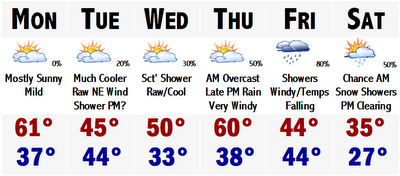
 After yesterday's snow flurries/showers/squalls, today have turned out to be a rather chilly day with highs in the lower 40's, which is still about five degrees above average. Normally, Boston should be around 38 degrees this time of year. We may actually get there tomorrow afternoon with a projected high of 38 degrees for Boston. We stay there again on Saturday with the possibility of a few snow flurries or snow showers widely scattered about the area. It looks like the best chances of seeing any snow Saturday will be north of the Mass Pike and especially in Central and Northern New England. A few favored ski resorts may actually get an inch to a couple quick inches of snow on the day Saturday. Wouldn't that be a nice surprise for the ski operators. There is a few snow showers up that way today in central-northern New Hampshire and SW Maine. A dusting to an inch or two cannot be ruled out with highs in the lower 30's at the bases of the mountains to mid - upper 20's at the summits.
 Sunday now looks like it will be a mostly dry day with increasing high cloudiness ahead of the next storm system, slated to arrive sometime in the predawn hours of New Year's Day, Monday.
 Here is the map for early Monday morning. Hopefully, this is past the midnight hour with many people outside celebrating New Year's and seeing the ice sculptures on the Common. This year looks to be fairly good for the sculptures with decently cool highs in the upper 30's with lows on New Year's Eve expected to drop into the upper 20's in the city to mid 20's in the suburbs. This will set us up for the storm system moving into our area on Monday morning. Here is the map for early Monday morning and it is showing much of MA above the 0C line with frozen precipitation falling. This could be freezing rain or sleet, closest to the line with a mixture of freezing rain/sleet/snow possible north of the Pike. Newest information actually is showing the possibility of this storm system starting as a brief period of light to moderate snowfall before turning to more of a wintry mix. Nonetheless, all wintry precipitation will turn to rain by Monday around noon, except in the deepest valleys where the shallow cold air may keep temperatures around 31 or 32 with freezing rain. These situations are very tough to forecast and can be called low confidence forecasts.
 Here is the map for early Monday morning. Hopefully, this is past the midnight hour with many people outside celebrating New Year's and seeing the ice sculptures on the Common. This year looks to be fairly good for the sculptures with decently cool highs in the upper 30's with lows on New Year's Eve expected to drop into the upper 20's in the city to mid 20's in the suburbs. This will set us up for the storm system moving into our area on Monday morning. Here is the map for early Monday morning and it is showing much of MA above the 0C line with frozen precipitation falling. This could be freezing rain or sleet, closest to the line with a mixture of freezing rain/sleet/snow possible north of the Pike. Newest information actually is showing the possibility of this storm system starting as a brief period of light to moderate snowfall before turning to more of a wintry mix. Nonetheless, all wintry precipitation will turn to rain by Monday around noon, except in the deepest valleys where the shallow cold air may keep temperatures around 31 or 32 with freezing rain. These situations are very tough to forecast and can be called low confidence forecasts.
 Wednesday, December 27, 2006
COOL TEMPS FOR A COUPLE DAYS AT LEAST
 Thought I would get in a quick post today to update you on the potential New Year's Day storm. Still looks like it will be a mainly rainstorm, however temperature profiles have trended colder with an expansive high pressure located over SE Canada, near Montreal. This high pressure system will actually keep the precip at bay for a couple of days, by the way it looks right now. Yesterday it looked like rain/snow/sleet would be moving in late Friday night and into Saturday, continuing for a few days. Now it looks like we will have a mostly sunny day on Saturday with increasing clouds on Sunday. With the storm being surpressed to the south for a couple of days by a Canadian high pressure system, I have trended the temperatures colder for Friday - Saturday. Mainly in the upper 30's. We will warm up somewhat on Sunday with highs in the lower 40's and rain developing late in the day. This will be similar to the setup we had Christmas Day. It may begin as a brief period of some sleet/freezing rain, northwest of Route 495, but will quickly transition to plain rain during the day Monday, all the way up to central and northern New England. The storm will come to an end on Monday night and Tuesday morning with leftover snow showers in the mountains of northern New England, with perhaps a small accumulation? Let's hope so. Anyhow, another pool of cooler air will move into all of New England Tuesday with highs back to seasonable levels, in the 30's. Other than that, there is no risk for any major, or even minor - moderate snowstorms for SNE in the near future. Maybe a few flurries this afternoon and tomorrow afternoon.
Monday, December 25, 2006
SKI RESORTS SMILING TONIGHT...
 Ok...now this is getting a little ridiculous. Another Christmas has come and gone and we are back to where we started. A snowless winter. I don't know what is causing this awful winter, whether it be El Nino, the strong PAC jet soaring across the country, or global warming, but it is starting to get depressing. This is just not a Boston winter at all. This type of winter has been comparable to an average Richmond, VA or Raleigh, NC average winter. Not that of a New England or Boston winter which is famous for its wintertime snowscapes. This is just getting sad.
Now that I have got that out of my system, lets look to the extended forecast to see if my prayers will be answered. In short, no. Don't get me wrong, snow will be falling in New England tomorrow and Winter Storm Warnings are posted for the spine of the Green Mountains and northern Vermont for 7-11" of snow, with Winter Weather Advisories for the valleys of Vermont and northern New Hampshire and much of Maine for about 3-5" of snow with ice/sleet further south. In northernmost Maine, Snow Adviories have been posted for about a good 4-7" snowfall from this storm system. Its snow and the ski areas desperately need it, but for a late December snowstorm in Northern New England, this ain't much, ain't much at all. This storm once looked very promising for a good 12"+ a few days ago, but has since weakened and lessened on the charts. Oh well, ski country will take what they can get and they will be making more snow with the colder temperatures forecasted.
Speaking of the colder temperatures, its going to go to seasonable levels around here by Wednesday through Thursday with temperatures generally in the mid-upper 30's in SNE to upper 20's to lower 30's in NNE. It will actually feel like wintertime for a change instead of this constant spring feeling we've delt with since it seems forever. Friday we will begin to moderate again ahead of the next storm. What else is new?
It looks like we will be having a wet holiday weekend next weekend to ring in the new year. It looks like a moderate to strong storm system will be taking shape in the middle Plain states and throw Gulf moisture all the way up the East Coast with moderate to heavy rains and warm temperatures once again. Too warm for snow, possibly even for NNE as well. It looks, at this point, that it will be another Great Lakes cutter, which will be a similar setup for precip type as we are dealing with tonight and tomorrow, but this one may be a tad warmer. So early call on this one is a mostly RAIN EVENT for SNE with a possible RAIN/MIX EVENT in NNE and the mountains. I know this is a very important weekend coming up with many "unsober" people driving Sunday night, so I will keep you intuned on the latest thinkings of this forecast.
Well, I think that is all for tonight and will just end it by saying Merry Christmas. I hope you all had a good one.
Sunday, December 24, 2006
I Hope Everyone Has a GREAT Christmas and Best Wishes to All
Taking a break from the weather for a bit, I just wanted to wish everyone a Merry Christmas in case I forget tomorrow in all of the hecticness of the day and forecasting of this upcoming storm system.
Best wishes too all and I hope everyone gets what they want and just have a great and healthy holiday.
Best wishes too all and I hope everyone gets what they want and just have a great and healthy holiday.
Saturday, December 23, 2006
BALMY WEATHER CONTINUES...
 I am a little pressed for time today, but hope this eases your hopes. There is NO snow coming Tuesday. We are on the warm side of the storm and will see 60's and rain/thunderstorms. No snow, not even on the back side. We just don't get backlash snows from inland runners because in order to get the snow we would have to have it survive the trip over the mountains, which is unlikely. So no snow is coming, just springlike air.
 All the snow will be confined to Kentucky, West Virginia and Cleveland and Upstate New York. Foot plus of windwhipped heavy wet snow there.
Sorry SNE guys. Better luck next storm and as Ray would say....NEXTT!!!!Friday, December 22, 2006
NO WHITE CHRISTMAS THIS YEAR...
 Well, another year and another brown Christmas for us in SNE. Areas to our west will likely see a white Christmas. We can pretend we live in the Rockies, Denver, New Mexico, northern Texas, Kansas, Nebraska, and the NW part of the Great Lakes. All of these places will likely see a white Christmas this year. Boston, we'll wait another year. I know you've been hearing talk of the possible post Christmas Day storm for the East Coast and I will get to that in a minute. First, I want to talk about the December 23rd storm. Also known as tomorrow's storm. It is a mild rainstorm. Highs tomorrow will soar to between 48-53 degrees with heavy rain throughout, heaviest in the morning with perhaps a widespread one inch plus of rainfall. No snow with this one, not even in ski country. Sorry.
 Christmas Eve looks perfect for last minute shopping. No snowstorms to get in our way, yet. Highs should range from the upper 40's to mid 50's along the coastal plain with a nice warming downslope wind off the mountains. Evening temperatures should be nice and mild in the 40's with midnight mass temperatures around 40-45 with dry conditions. Santa will have no trouble contending the weather this year in SNE, as it will be a dry night and dry morning on the 25th. Storm clouds do not move in until about 12-2PM on Christmas Day. At this point, it may be snowing from northern Mississippi to Tennessee to Kentucky. Not good news for us as the storm will be forming and strengthening, but looks to go far enough inland for a mild rainstorm once again for most of the East Coast on Monday night into Tuesday.
 There are 3 major possible scenarios and tracks for this first considerable winter storm to take.
TRACK ONE: This is the track furthest west, west of the Apps. I will say right out that this track, ATTM, does not look likely, but has some support from the models. A track like this would mean bad news for major cities like Nashville, TN; Cincinnatti; Indianapolis; Detroit; and perhaps as far west as Chicago. Northern Mississippi and Alabama could see some snow as well as NE Arkansas seeing a healthy dose of snow. This track is only if the two streams, northern and southern, phase very early in the storm's development and rocket it up west of the Apps. In the cities mentioned above, easily 6"+ of heavy snow would be likely. Something to watch.
TRACK TWO: Track two is also a very exciting track as well. Track two brings the storm up from the NW Gulf of Mexico, amped with tons of Gulf moisture and tracks it along the Apps. Good news for the Smokey's in TN; Apps from NC to WV; snow would also be falling from the Tennessee Valley through the Ohio Valley through Michigan and central and western PA and upstate NY with healthy snows again probably in the 6-10" category for the cities to a foot plus along the mountains. A track up the Apps usually means an energy transfer from the initial storm to a storm redeveloping along the Atlantic coast. This looks like what would happen. The primary storm would then become entrenched of the Delmarva and rocket up the Hudson Valley. This track could change rain to snow in eastern PA and even NYC's NW suburbs. This will enhance the snow in the western NY area, namely Syracuse, Utica, ect; with enhanced snowfall totals surpassing 12 inches likely. Northern New England would also eventually get into the act with several inches of snow on the backside as well. You know those lucky mountain in northern VT, and NH, and ME that would benefit with the downsloping snows from the backside of a powerhouse 985ish type storm with strong winds. Ski resorts here could easily see 10-20 inches of snow.
TRACK THREE: Track three is a track that has about a 30-40 percent chance of panning out. This track would involve a much weaker storm that would kind of just stay progressive and jut out off the Virgina coast and skirt to the south of the Cape and Islands. This "weaker" storm" would limit the amount of places affected by this storm, but would ensure a decent swath of a 2-4" or 3-6" snow from central-eastern PA; NW of NYC; into much of SNE. We would not see powerhouse numbers, but if this storm were a little stronger than forecasted, somebody would likely wind up with a solid 6"+.
As you can tell, there is much going on and I am going to put the BOTTOM LINE on this storm right now. There will be a moderate to major winter storm...Category 3 or 4...early next week and places will get decent snowfall with a moisture loaded system. Where it tracks and how strong it is, is yet to be seen. By Sunday, I would guess that all the models will start to fall into place and we will have a better idea of what to expect with this potential monster of a storm.
I know I am praying for Track Three!
WINTER STORM LOOMING
Very good read on the possible storm around here the day after Christmas. This is from the Boston Forecast Discussion.
"FORECAST CONCERNS REVOLVE AROUND THE POTENTIAL FOR A FORMIDABLE EAST COAST STORM STARTING LATE XMAS DAY INTO THE NIGHT OF THE 26TH. THE 00Z GFS AND 00Z ECMWF ARE IN NEAR-PERFECT AGREEMENT TONIGHT AT H+120 AFTER VERY LARGE DIFFERENCES ON THEIR RUNS 24 HOURS AGO. BASICALLY...BOTH PUT A 985-ISH LOW JUST E OF BOSTON BY TUE EVENING. UNFORTUNATELY FOR SNOW LOVERS...THERE WILL PROBABLY CONTINUE TO BE A SCARCITY OF COLD AIR.IN ANY EVENT...FIRST THINGS FIRST. ANY PRECIP ASSOCIATED WITH FIRST SYSTEM SHOULD BE QUICKLY MOVING OUT EARLY SAT EVENING...IF NOT GONE BY THEN. BLUSTERY NWLY FLOW UNDER CLEARING SKIES SAT NIGHT IN THE WAKE OF THE DEPARTING LOW.SUN...XMAS EVE...BLUSTERY NORTHWEST FLOW CONTINUES UNDER MOSTLY SUNNY SKIES. PERHAPS A PERIOD OF BKN STRATO-CU OVER NORTHWESTERN ZONES DURING THE AFTERNOON. DOWNSLOPE FLOW AND 850 TEMPS JUST ABOVE ZERO SHOULD ALLOW TEMPS TO RISE TO AROUND 50 AT MOST LOCALES.HIGH PRESSURE MOVES IN AT THE SFC SUN NIGHT WITH DIMINISHING WINDS AND MOSTLY CLEAR SKIES. NEAR-SEASONABLE LOWS SHOULD BE EXPECTED.SOUTHERN STREAM SHORT WAVE WILL CONTINUE MOVING RAPIDLY NORTHEASTWARD ACROSS THE DEEP SOUTH STATES SUN NIGHT...AND INTO THE MID ATLANTIC ON XMAS DAY. MODELS ARE NOW IN BETTER AGREEMENT WITH THIS SCENARIO. THIS IS THE WAVE THAT ALLOWS FOR GULF CYCLOGENESIS SUN...WHICH CONTINUES UP THE COAST SUN NIGHT AND MON. A SECOND SOUTHERN STREAM SHORT WAVE IS THEN PROGGED TO FOLLOW IMMEDIATELY BEHIND THE FIRST...WHICH IS THE STRONGEST OF THE TWO. THIS IS THE ONE THAT LOOKS TO REALLY SPIN UP THIS STORM AS THE WAVE PHASES WITH THE NORTHERN STREAM. IT'S STILL TOO EARLY TO PREDICT THE EXACT TRACK AND TIMING...BUT IT DOES LOOK LIKE A PRETTY FORMIDABLE LOW PRESSURE CENTER WILL BE MOVING UP THE COAST XMAS NIGHT...AND INTO NEW ENGLAND ON TUE...EXITING TO THE NORTHEAST TUE NIGHT.WARM AIR ADVECTION PRECIP ASSOCIATED WITH THIS DEVELOPING AREA OF LOW PRESSURE LOOKS TO MOVE NORTHWARD INTO SOUTHERN NEW ENGLAND DURING THE AFTERNOON HOURS ON XMAS DAY. AS MENTIONED ABOVE...AND AS EVERYONE KNOWS BY NOW...COLD AIR HAS BEEN HARD TO FIND SO FAR THIS DECEMBER AND IT LOOKS LIKE THIS TREND WILL CONTINUE. THUS...EXPECT LIGHT RAIN TO OVERSPREAD SOUTHERN NEW ENGLAND FROM SOUTH TO NORTH XMAS AFTERNOON WITH HIGHS IN THE 40S. EXTREME NORTHWESTERN SECTIONS OF THE CWA COULD SEE A MIX OF RAIN AND SNOW. AS THE LOW CONTINUES TO MOVE UP THE COAST MON NIGHT...THE WARM AIR SHOULD HOLD TOUGH...SO EXPECT RAIN ACRS MOST OF THE CWA...EXCEPT PERHAPS NORTHWESTERN MOST ZONES. LOWS SHOULD BE IN THE 30S FOR THE MOST PART...EXCEPT PERHAPS THE CAPE/ISLANDS/SOUTH COAST WHERE LOWS WILL LIKELY ONLY BE IN THE 40S...MAYBE EVEN 50.IT'S HARD TO SAY WHERE THE LOW WILL TRACK EXACTLY LATE MON NIGHT INTO TUE. 00Z GFS ENSEMBLE MEAN HAS THE LOW PASSING OVER THE SOUTH COAST WHILE THE 00Z OP GFS AND 00Z ECMWF HAVE IT PASSING INLAND...THEN EXITING THE COASTLINE BETWEEN BOSTON AND PORTLAND EARLY TUE EVENING. THIS IS ACTUALLY EXCELLENT MODEL AGREEMENT FOR A 5 DAY FORECAST. UNFORTUNATELY THIS IS LIKELY TOO GOOD TO BE TRUE...AND I WOULD EXPECT SOME MODEL FLIP-FLOPPING OVER THE NEXT COUPLE OF DAYS.WILL FORECAST RAIN CHANGING TO SNOW WEST TO EAST DURING TUE AFTERNOON INLAND AND TUE EVENING TOWARD THE COAST. TOUGH TO SAY HOW MUCH SNOW WE'LL GET...BUT IF THE LOW TRACKS OVER THE CAPE AND ISLANDS...A GOOD PORTION OF THE CWA COULD GET SOME ACCUMULATING SNOW LATE TUE AFTN AND TUE NIGHT AS IT RAPIDLY INTENSIFIES AND MOVES AWAY FROM THE REGION. LOTS OF TIME TO LOOK AT THIS. IN A NUTSHELL...MAINLY RAIN STARTING LATE XMAS DAY THROUGH A GOOD CHUNK OF TUE...CHANGING TO SNOW LATE TUE AFTN/NIGHT. WINDY TOO. COULD GET VERY GUSTY AS THIS LOW DEPARTS.STILL LOTS OF POSSIBLE SCENARIOS WITH THIS LOW AND IT'S TRACK."
"FORECAST CONCERNS REVOLVE AROUND THE POTENTIAL FOR A FORMIDABLE EAST COAST STORM STARTING LATE XMAS DAY INTO THE NIGHT OF THE 26TH. THE 00Z GFS AND 00Z ECMWF ARE IN NEAR-PERFECT AGREEMENT TONIGHT AT H+120 AFTER VERY LARGE DIFFERENCES ON THEIR RUNS 24 HOURS AGO. BASICALLY...BOTH PUT A 985-ISH LOW JUST E OF BOSTON BY TUE EVENING. UNFORTUNATELY FOR SNOW LOVERS...THERE WILL PROBABLY CONTINUE TO BE A SCARCITY OF COLD AIR.IN ANY EVENT...FIRST THINGS FIRST. ANY PRECIP ASSOCIATED WITH FIRST SYSTEM SHOULD BE QUICKLY MOVING OUT EARLY SAT EVENING...IF NOT GONE BY THEN. BLUSTERY NWLY FLOW UNDER CLEARING SKIES SAT NIGHT IN THE WAKE OF THE DEPARTING LOW.SUN...XMAS EVE...BLUSTERY NORTHWEST FLOW CONTINUES UNDER MOSTLY SUNNY SKIES. PERHAPS A PERIOD OF BKN STRATO-CU OVER NORTHWESTERN ZONES DURING THE AFTERNOON. DOWNSLOPE FLOW AND 850 TEMPS JUST ABOVE ZERO SHOULD ALLOW TEMPS TO RISE TO AROUND 50 AT MOST LOCALES.HIGH PRESSURE MOVES IN AT THE SFC SUN NIGHT WITH DIMINISHING WINDS AND MOSTLY CLEAR SKIES. NEAR-SEASONABLE LOWS SHOULD BE EXPECTED.SOUTHERN STREAM SHORT WAVE WILL CONTINUE MOVING RAPIDLY NORTHEASTWARD ACROSS THE DEEP SOUTH STATES SUN NIGHT...AND INTO THE MID ATLANTIC ON XMAS DAY. MODELS ARE NOW IN BETTER AGREEMENT WITH THIS SCENARIO. THIS IS THE WAVE THAT ALLOWS FOR GULF CYCLOGENESIS SUN...WHICH CONTINUES UP THE COAST SUN NIGHT AND MON. A SECOND SOUTHERN STREAM SHORT WAVE IS THEN PROGGED TO FOLLOW IMMEDIATELY BEHIND THE FIRST...WHICH IS THE STRONGEST OF THE TWO. THIS IS THE ONE THAT LOOKS TO REALLY SPIN UP THIS STORM AS THE WAVE PHASES WITH THE NORTHERN STREAM. IT'S STILL TOO EARLY TO PREDICT THE EXACT TRACK AND TIMING...BUT IT DOES LOOK LIKE A PRETTY FORMIDABLE LOW PRESSURE CENTER WILL BE MOVING UP THE COAST XMAS NIGHT...AND INTO NEW ENGLAND ON TUE...EXITING TO THE NORTHEAST TUE NIGHT.WARM AIR ADVECTION PRECIP ASSOCIATED WITH THIS DEVELOPING AREA OF LOW PRESSURE LOOKS TO MOVE NORTHWARD INTO SOUTHERN NEW ENGLAND DURING THE AFTERNOON HOURS ON XMAS DAY. AS MENTIONED ABOVE...AND AS EVERYONE KNOWS BY NOW...COLD AIR HAS BEEN HARD TO FIND SO FAR THIS DECEMBER AND IT LOOKS LIKE THIS TREND WILL CONTINUE. THUS...EXPECT LIGHT RAIN TO OVERSPREAD SOUTHERN NEW ENGLAND FROM SOUTH TO NORTH XMAS AFTERNOON WITH HIGHS IN THE 40S. EXTREME NORTHWESTERN SECTIONS OF THE CWA COULD SEE A MIX OF RAIN AND SNOW. AS THE LOW CONTINUES TO MOVE UP THE COAST MON NIGHT...THE WARM AIR SHOULD HOLD TOUGH...SO EXPECT RAIN ACRS MOST OF THE CWA...EXCEPT PERHAPS NORTHWESTERN MOST ZONES. LOWS SHOULD BE IN THE 30S FOR THE MOST PART...EXCEPT PERHAPS THE CAPE/ISLANDS/SOUTH COAST WHERE LOWS WILL LIKELY ONLY BE IN THE 40S...MAYBE EVEN 50.IT'S HARD TO SAY WHERE THE LOW WILL TRACK EXACTLY LATE MON NIGHT INTO TUE. 00Z GFS ENSEMBLE MEAN HAS THE LOW PASSING OVER THE SOUTH COAST WHILE THE 00Z OP GFS AND 00Z ECMWF HAVE IT PASSING INLAND...THEN EXITING THE COASTLINE BETWEEN BOSTON AND PORTLAND EARLY TUE EVENING. THIS IS ACTUALLY EXCELLENT MODEL AGREEMENT FOR A 5 DAY FORECAST. UNFORTUNATELY THIS IS LIKELY TOO GOOD TO BE TRUE...AND I WOULD EXPECT SOME MODEL FLIP-FLOPPING OVER THE NEXT COUPLE OF DAYS.WILL FORECAST RAIN CHANGING TO SNOW WEST TO EAST DURING TUE AFTERNOON INLAND AND TUE EVENING TOWARD THE COAST. TOUGH TO SAY HOW MUCH SNOW WE'LL GET...BUT IF THE LOW TRACKS OVER THE CAPE AND ISLANDS...A GOOD PORTION OF THE CWA COULD GET SOME ACCUMULATING SNOW LATE TUE AFTN AND TUE NIGHT AS IT RAPIDLY INTENSIFIES AND MOVES AWAY FROM THE REGION. LOTS OF TIME TO LOOK AT THIS. IN A NUTSHELL...MAINLY RAIN STARTING LATE XMAS DAY THROUGH A GOOD CHUNK OF TUE...CHANGING TO SNOW LATE TUE AFTN/NIGHT. WINDY TOO. COULD GET VERY GUSTY AS THIS LOW DEPARTS.STILL LOTS OF POSSIBLE SCENARIOS WITH THIS LOW AND IT'S TRACK."
Thursday, December 21, 2006
RAINSTORM SATURDAY
 Chilly temperatures tomorrow in SNE with highs in the low to mid 40's. It will still be above average and in fact will be the 12th day in a row that Boston has recorded above normal temps. With the heavy rains moving in tomorrow night, the temps will go back up into the 50's once again. Christmas Eve "Day" will be nice and mild with highs in the 50's and then chilling down a bit for Christmas Day. A potential Nor'easter moves in Mon. night into Tuesday with a mix of rain and snow NW and rain Boston. At least that what it looks like now. May continue into Wednesday. Nothing major.
Wednesday, December 20, 2006
A MILD THURSDAY
 It was finally a average day today...kinda. Highs ranged from around 40 to 45 with a persistent breeze making it feel like the 30's. Nothing really to talk about, really not feeling that good of late. There are a couple of storm chances coming up. The first comes late Friday into Saturday with what looks to be a mostly rain event. It may start as a period of mixed precipitation over NW zones late Friday night as temperatures will be around the freezing mark. This mixed bag, if it does occur, will be shortlived and transition to all rain by Saturday morning. We could be talking about a soaking rain with perhaps 1/2" to 1" of rain. It will likely be rain for all of New England, barring the highest peaks in northern New England where there may be some snow accumulation. IE: Mount Washington, Mount Mansfield.
 After Saturday's RAINSTORM, Christmas Eve looks to be mild with highs around or slightly over 50. Christmas Eve (night) will be mild and midnight masses will likely be in the upper 30's to lower 40's. This will set us up for a mild Christmas Day. Highs will be in the 40's, but a front will be approaching from the NW as an area of High Pressure will be spreading in marginal cold into New England.
Then it gets interesting...A storm system will be developing in the northern half of the Gulf of Mexico and will be accelerating northeastward through GA through western NC and VA. This storm track will likely bring some accumulating snows from Nashville, TN to parts of KY and WV. The low pressure will be off the coast of Norfolk, VA by Christmas Day, spreading rain along the coastal areas with wet snow possible near Washington DC. There will be a rain/snow line with this storm. It will be gaining strength as it really hugs the coastline. This hugging of the coast will likely flood most of SNE with enough mild air to keep most of area SE of Worcester and Boston, a mainly rain event. Thats how it looks right now. Most of the I-95 cities will have a mainly rain event, but we all may see a quick change to snow at the end Tuesday night. The details with this storm are still way up in the air, so don't take these as the final details on this possible storm. Things will most definitely change as you already know with previous forecasts of storms this winter. Its still 144+ hours out.
Stay tuned and Merry Christmas!
Saturday, December 16, 2006
A CALIFORNIA TREAT
 Another New England December day and another day approaching 60 degrees. This has pretty much become the norm. Tomorrow will be one of the nicest days since about last week. Skies will be mostly sunny with temperatures soaring to between 55-60. The Patriots are hosting the Houston Texans tomorrow at Gillette at 1PM. I am forecasting gametime temperatures to be at 59 degrees. During the course of the game it may nudge 60 and then fall through the mid 50's by the time it ends. Monday will be the last mild to warm day for a while as we will be having a short return to winter temperatures. Highs Monday will be around 50-55.
 Monday night we will see a sprinkle or two and as the cold front moves through our area from the NW during the course of the night, those sprinkles may turn into a snowflake or two. Maybe enough moisture to squeeze out a snowshower in the hills of Worcester and Keene, NH. A dusting there maybe? Thats about it. I should at least mention that there is the smallest chance that with the NNW winds, we could see some OES on the outermost Cape during the evening hours of Tuesday with perhaps a coating of snow, but that is not what I am forecasting at the moment.
Wednesday will be mighty chilly around here with highs struggling to make it into the upper 20's in Worcester, to lower 30's around Boston, and mid-upper 30's on the South Coast and Cape. That will be all of the cold we will see as we will be pushing 40 on Thursday and then pushing 50-55 again on Friday with rain likely holding off now until Christmas "Eve" Eve. It looks like a storm will be heading well to our west, so we will be on the warm sector of the storm with showery rains and mild temperatures. Sorry, I wish I had better news. All you eastern weather forum guys will be going crazy with this forecast. I am too. I am too.
Thereafter, it may cool down slightly again after Christmas Day, but I see no reason why it would be anything more than a shortlived coolspell like what we will see on Tuesday and Wednesday of this week.
If you just moved to Boston and you think this is normal, I want to stick up for the Boston Winter and say this is definitely the exception. It is usually not like this. Hopefully, we will be able to show all you newcomers our true colors soon. Until then, enjoy our California treat.
Wednesday, December 13, 2006
SNOW DROUGHT CONTINUES...ANY HOPE?
 What is going on? This is starting to get ridiculous. Being a snowlover, this is starting to become unbearable. It could be worse though. Reading a post from Accuweather, senior meteorologist John Kocet, has not seen a single snowfall of 3"+ in exactly one year Friday. Well, you must be thinking, is he from Atlanta, GA. No, maybe Dallas, TX. No, would you be surprised to find out that he is talking about State College, PA. State College is right in the middle of Pennsylvania. He has seen no significant snow in over one year, actually since last FALL! Amazing.
Our Winter 2006 - 2007 snow drought is continuing this week. We are not even coming close to having any type of snow. "When it rains, it pours." Highs tomorrow will be pushing the upper 50's - around 60! This is after today's front pushes through with about a tenth to three-tenths of an inch of rain from the South Coast all the way to Caribou, ME. No snow with this one, even on the highest mountain tops. The "Pacific" mild trend will continue into this weekend, with a cooler Saturday with temperatures in the upper 40's to around 50. Sunday, ahead of a cold front, we will be in the grips of a strong SSW flow, bringing in all sorts of mild air. Accompanying this extremely mild air will be a few widely scattered showers, but Sunday will not be a washout by any means. In fact, it will be a good day to get outside and soak up all of this warm air, surely an early Christmas gift. Sunday's highs, easily 55+. We could see a few 60 degree readings.
After the front goes through Sunday, expect cooler weather for Monday with highs in the mid 40's. We step down a little more Tuesday with highs in the mid-upper 30's, but at this point, it looks to be mostly dry with no snow through day 6-7. However, we could be taking a turn back to colder and snowier? weather as the NAO may be trending more negative during Christmas week. Are our prayers for cold and snow about to be answered? That answer will be unveiled in the days to come.
Tuesday, December 12, 2006
MILD TIMES CONTINUE..
 Rain is moving in for tomorrow afternoon. Nothing heavy. Just some dampness. Its in at NOON and out by 5PM. Nothing major. After that mild times will continue with temperatures in the 50's. Next shot of real rains comes in around Monday night of next week.
Enjoy your week, will have limited posts as there is really ot much to talk about...except that there is only 11 days left of Christmas shopping. Enjoy the mild times.
Saturday, December 09, 2006
MILD TIMES AHEAD...
 Posting really quick...
 But it looks like after yesterday's bust of a snow, mild air will dominate our forecast once again. Highs should be back into the 50's Sunday and Monday, a brief cooldown Tuesday with a backdoor coldfront from the NE, and then back to the mild stuff. Highs back to around 60 by late week. Rain will move in towards the end of the week, with a possible coastal rainstorm off the five day. It could lead us into colder times for after the December 19th period. We'll have to wait and see.
Otherwise, have a good Saturday night, and I will see you tomorrow.
Thursday, December 07, 2006
HECTIC FRIDAY AM COMMUTE?
I have been watching this possible snowy situation for tonight for the past few days. An arctic cold front will be crossing our area later tonight into early tomorrow morning. Front will be accompanied by a drastic temperature drop and this will be enough instability to kickoff some snow showers and squalls tonight. Some of these squalls could be very heavy.
Currently, western Massachusetts and southern Vermont is under a WINTER WEATHER ADVISORY for the potential of 3-8" of snow as reported by the NWS early this morning. I don't totally agree with this forecast as I think that most areas will see 3" or less. I suppose the highest peaks and mountain resorts may see up to 5-6", but that would be pushing it, even with the expected 15:1 or 18:1 ratio forecasted. Around here, we may see squalls giving us a light accumulation of snow. These "windex" events are extremely hard to forecast as one town may get blasted with near whiteout conditions for 10-20 minutes, while just down the road they barely see a flake. However, I believe that many will see at least some snow accumulation tonight, or at least see some flakes.
Around here I am expecting possible accumulations to be like this...
Boston Metro (Boston, Inside Route 495): Coating - 2"
Cape Cod (Including the Islands): Coating - 1"+ (ocean effect Fri???)
Rhode Island (North): Trace - 1" (South): Trace
Worcester County (Fitchburg, Orange, Springfield) Coating - 2"
Conneticut (Eastern): Trace - Coating (Litchfield Co.): 1-3"
Western MA (Berkshires): 2-4"
Southern VT: 2-5"
Southern NH (Nashua, Manchester, Derry): 1-2"
It is hard to go town by town with this one as it will be very localized, but many areas have a shot at seeing snow. Not a big event by any means, so did not even bother to post a snowfall map. Sanders may have to be used tomorrow morning and people may need to remember to drive on this stuff as many will be caught off guard tomorrow morning when they get home from work with temperatures in the mid 50's. Good luck to the uninformed. It will be a shock. Tomorrow will be the coldest day since last winter with highs ranging from 25-30 in southern New England and ranging from 15-25 in northern New England. Don't worry, it will warm up again and by Sunday all will be forgotten and melted as highs will be back into the 50's yet again.
Wednesday, December 06, 2006
2006 WINTER FORECAST CONTEST...
"New England Weather" run by Joel, www.sneweather.blogspot.com is running its annual winter forecast contest...
I said that I would post the details of the contest on this site so here they are:
Ok, so the 2006 Winter Forecast Contest is back. The directions are rather simple. You must predict the winter snowfall for the following cities (to the nearest whole number). Tie breaker will be the date of the last snowfall at Logan Airport, in Boston. So, here are the cities:
Boston (BOS)
Providence (PVD)
Hartford (BDL)
Worcester (ORH)
Bridgeport (BDR)
Nantucket (ACK)
Please email Joel your predictions (mattmfm@aol.com) or post them in the comments section.Contest closes on December 15, 2006. Joel will make a list of the contestants and their predictions after the contest closes.
Meanwhile, I hope to post soon, as there is some weather stuff to talk about, including some potential snow tomorrow night into Friday morning. Before you get too excited, let me tell you that its just a chance of snow showers and squalls with the passage of a front. Tomorrow will be milder with highs in the upper 40's to around 50. Friday after morning flurries may be hardpressed to get out of the 20's inland and above freezing in Boston and along the coast. Cold snap won't last long, moderating temperatures into the weekend. Highs back in the 50's by Sunday.
Make your predictions...
Tuesday, December 05, 2006
HOPE TO POST SOON...
Hi everyone. Mr. Foot's winter forecast finally came out today. It was a very nice read. I encourage all of you to go and read it. I pretty much agree with his forecast. I will be in Italy February 14-25th, so thats when we will probably see all of our snow.
But, I will not be able to post for a while, a few days or so, so until then, I encourage you all to go to New England Weather (sneweather.blogspot.com) or Foot's Forecast (footsforecast.blogspot.com) to find the latest on the forecast and find good reads. Two best sites for the weather.
Until we meet again, see you later.
Sunday, December 03, 2006
DOWNGRADING FURTHER...
 Sorry had to do it. I am trying not to be a model hugger, but the NAM is barely putting anyone NW of Boston under any kind of precip. This is just a nightmare forecast that has gotten forecasters all over the place. Best thing would have been to have just forgotten about it and move on, like I was feeling Thursday night, before Friday started the fun.
Better luck next time and I will leave the next word for Ray on this storm. The only thing we can hope for now NW of Boston is to at least see some snow flakes. Adios.
FIRST (little) SNOW ON THE WAY...
 Sorry for taking so long to get this out there. I don't want to list my excuses, but, just say sorry for the delay.
 Now for the snow. It has lost its punch from Friday afternoon. Thats where I got the forecast map from the last post. This thing, at that time, looked like a MONST-AH! Now, not so much. Looks like a little lamb. Snow will fall, mainly away from the coast, away from the Cape, and inside of Route 495. So if you meet these three requirements, expect 1-3" of snow. Not much, I know, but it will be the first time any of us have seen snow in our backyards since April 5th. Backside of snow will be around Springfield to Manchester, NH and into Maine. NAM, now is portraying the least amount of snow for areas NW of Boston...perhaps a coating to an inch on the grassy surfaces. GFS is better with perhaps a few inches all the way to Worcester. I took a road in the middle to give you this map. Cape, expect mostly rain and maybe a quick changeover to at least see your first flakes of the season. Sorry that 4-8" forecast didn't verify. Or maybe you are cheering it didn't.
Time table for this is light rain/mix NW moving in tonight. Then changes to a quick bout of snow for many other than the Cape with the main accumulation. Will likely end around 10AM to NOON...from NW to SE
Will post again if anything changes and won't wait two days to do so. There is a chance areas just WSW and WNW of Boston may have a SNOW ADVISORY posted this afternoon. I will keep you posted. I have a family party from around noon to 3PM, so hopefully nothing happens then and I'm so mad I'm missing the Pats game, but thats a different story.
Friday, December 01, 2006
HOLD ON NOW...WHAT ABOUT MONDAY!?
 Okay, okay, okay, I have heard and read all of your messages now. I know you guys think I am crazy not immediately changing the forecast with the change in the track. The NAM came out today and it was pretty much going GANG-BUSTERS with lots of New England snow. However, with each run of the computer models, the outer Cape and the Islands may see some mixing in with rain, limiting snowfall accumualtions. Earlier today, it looked like someone from southern CT to Hyannis would have been able to see up to a foot of snow. NAM has started to back down from this hypothesis, with perhaps up to 4-8" of snow. I must say that this may be a little too high with the current information. Something to watch. Further N&W, towards Boston and its northwestern suburbs, it will likely be an all snow event with about 2-4" of snow. There will be a tight and sharp cutoff so areas west of Worcester and Lemonster will likely see just a few flurries. This is going on the latest runoff of the NAM model. We are still 60-70 hours away from this event. Things will likely change. This is what I am going for, for now.
Here is the five day. As you can see, after temperatures in the upper 60's to around 70 the past few days, it will be a shock. There is the Monday snow threat, and then we are back to windy and cold Tuesday with perhaps a period of light snow or flurries Tuesday night into Wednesday morning. Nothing major. Seasonable December cold continues to round out the first full week of December.
Check in tomorrow to see the latest update on the snowfall accumulation.
Thursday, November 30, 2006
MONDAY STORM UPDATE: Looks to be "Out to Sea"
 Its 70 degrees in Boston right now at 2:30PM. We beat the record high previously held by an 1885 temperature of 68 degrees. Tomorrow will be another warm one with highs in the mid to upper 60's again. Rain will develop during the morning and become steadier and heavier as the day progresses. We could get a thunderstorm too, with up to 1-2" still of rain. Nothing compared to the 12-18" of snow in northern Oklahoma today with a swath of 6-12" from KC to STL to CHI. We will be missing out on that one.
It also looks like we will be missing out on the Monday storm as well. I was hesitant to take it completely out of the forecast, but run after run since last night of the GFS has continued to take this storm well out to sea, perhaps giving the Cape and passing flurry or sprinkle. The cold behind the storm does not look to be as harsh as previously thought as well. It will still be chilly with highs in the upper 30's, but not the upper 20's it looked like yesterday. This is mainly because yesterday's runs were taking into effect a snowcover, which is not going to happen now. I should have stuck with my guns in the beginning telling Jen to fo-get about it. The Canadian that was showing a hit yesterday is taking this storm even further out to sea than the GFS now. I am not buying into this storm. Its going to be a bust! Do not get your hopes up, just pretend there was never any chance of it coming here and you'll feel better. No snow looks to be in our immediate future.
As Eric and Ray say...NEXTTT!!!!!!!
Wednesday, November 29, 2006
Major Storm Brings Major Changes
Things are starting to get interesting in the weather department this week. What a crazy week. Temperatures are ranging from about -25 degrees for morning lows in Montana to highs in the upper 80's in south Texas. Seattle, WA has become the arctic tundra with snowstorm after snowstorm, they are under another Winter Storm Warning for up to a half a foot of snow tonight, the Southern Plains from Dallas, through Oklahoma, Kansas, Arkansas, Missouri, Illinois, Indiana, Ohio, and southern Michigan will all be hit with a major snow and icestorm with this latest storm from tonight through Friday. Snowfall accumulations could range from 1-3 inches in Dallas, 4-6 inches in much of Oklahoma and Kansas, and there may be a "jackpot" somewhere from just north of St. Louis to just south of Chicago, hopefully, of a swath of snowfall approaching 10-15 inches.
 First, tomorrow is going to be in the upper 60's to around 70 in Atlan...no, no, I mean Boston tomorrow. It will be a very balmy springlike feeling day. Morning lows will start around 60. A good jumping pad. Friday is when the rain will move in with up to one or two inches of soaking rain. It will still be mild with highs early around 60. It will turn much colder Friday night with any rain changing to snow across the northern New England mountains where a few inches of snow may accumulate on the highest peaks. That will clear and then lead us into a chilly Sunday with highs in the middle 30's.
 First, tomorrow is going to be in the upper 60's to around 70 in Atlan...no, no, I mean Boston tomorrow. It will be a very balmy springlike feeling day. Morning lows will start around 60. A good jumping pad. Friday is when the rain will move in with up to one or two inches of soaking rain. It will still be mild with highs early around 60. It will turn much colder Friday night with any rain changing to snow across the northern New England mountains where a few inches of snow may accumulate on the highest peaks. That will clear and then lead us into a chilly Sunday with highs in the middle 30's.
 Then comes the big story for Monday. It is up in the air. There is a 50/50 chance of seeing a SNE special for Monday. Right now, I am going with the pessamistic viewpoint with it coming close enough to us for a little light rain and light snow. However, with this fast, west to east flow, I do not see the storm really "bombing" out until it is way past SNE. I do NOT think that we will see much if any snow out of this one in the Boston metro area. The pattern we are in is very progressive with fast moving storms. I do not see this storm moving slow enough to gain enough strength for a major snow or rain Monday. With this progressive fast moving pace of storms, I think it will jug along in the jet and spread a shield of organized spotty precipitation. Southeastern MA and the Cape will probably see steady light rain or drizzle. The cold will be ousted by the warm marine water off the Atlantic. Keep in mind that the temperature of the water in Boston Harbor today was 50 degrees. North and west of Boston, I think that there will be wet snow and flurries with perhaps a skim coating. If the storm were to strengthen into a monster and hit us, warm air from the ocean would likely keep it all rain south and east of Boston. It would turn any snow to rain quickly from Boston northwest to Route 495 and Worcester. Jen, you would probably see accumulating snow. Ray and myself around Woburn/Wilmington would probably see a quick bout of snow changing to rain then maybe a quick shot of snow at the tail end?
So, for now keeping the chances of this storm very minimal, only posted a 40 percent chance in the FIVE DAY. Keep tuned though as you know that these storm's have a mind of their own. We are still FIVE days out. Thats all for now, so enjoy the tropical like warmth tomorrow and get out there and play catch or go for that jog around the pond.
Later.
Tuesday, November 28, 2006
Broken Record: Temps Pushing 70 By Thursday!
 Its that time of the week again. Time to say how amazingly warm it is about to get, yet again, now only days away from the arrival of December. Today we had a fairly typical New England November day with highs in the low 40's with a wind off the water with patchy drizzle and dark overcast skies. It was actually a little chilly today. No fear, tomorrow will start the rebound. After a chilly start with temperatures in the mid 30's to head off to work and school, temperatures will rebound to around 50. A little warmer towards CT, cooler north. Then there is no stopping the rollercoaster ride heading into Thursday. Another Thursday and another headline of pushing 70 by Thursday. Highs probably will not reach 70, but it will soar remarkably into the mid-upper 60's, an amazing feat for this late in the year with such a low sun angle. The rain, mostly showers, move in overnight Thursday and persist most of the day Friday. Once the front passes, rain may briefly change to snow across the northern New England mountain tops with perhaps a light accumuation. This front will mark the end of the April like warmth here.
 Saturday will sort of be a transition day. It will not be mild by any stretch of the imagination, but it will not be arctic cold. It will be reasonably or seasonably chilly with highs like we had today, mainly low-mid 40's, but with more sunshine, under partly cloudy skies. It will get cold though. Highs Sunday, for the Patriots game at Gillette will be chilly. Highs may struggle to reach the mid 30's. Gametime temperatures will likely be around 35 degrees at 1PM for the kickoff at Gillette Stadium. There won't be snow, which I guess is a good thing for the fans. Fans in Seattle were not as lucky last night, dealing with a very rare Seattle Snowbowl last night on Primetime Monday Night Football. It was pretty cool to have a city like Seattle showcase real football weather.
Monday the cold will truly be entrenched as highs even in Boston will probably stay around the freezing mark, mainly lower 30's. A storm looked like it was going to be threatening our area sometime Monday with light to moderate snowfall, especially south and east of Boston, but it looks with each passing run of the computer models, the idea of this potential storm and chances of it bringing us our first snow are dwindling. In other words, don't bet on it.
I guess thats all for tonight. Enjoy Thursday's amazing warmth and stay warm (and dry) tonight.
Sunday, November 26, 2006
BIG STORY: Major Changes Late Week
If you have not already heard it on the news and what not, there are major changes looming late week for SNE and much of the eastern half of the country. The West is already going under these changes. Snow levels are nearly down to sea level there, which is very rare. This morning, at one point, Seattle was experiencing Heavy Snow with a temperature of 33 degrees. More snow and cold is in their forecast for tonight and into tomorrow. Accumulations around the Seattle metro area should range from about a slushy inch in the city to 1-3 inches just outside of the city. Above pass level and into the mountains, forget about it. They will be measuring the snow in feet.
 Okay, I know you did not come to this site to find out the weather for Seattle, so I will get back to Boston. I just thought it was odd that Charleston, SC and Orlando, FL and Seattle have seen their first snows before Boston or Portland, ME. Whacky.
12z Run of the GFS ~ November 26, 2006
 Located to the left is the 12z run of the GFS computer model. The blue bar is the "540 Line." This usually correlates to the hard to predict rain/snow line. If you look at this real hard you will see that the blue line is situated through Long Island, southern Rhode Island, and southeastern Massachusetts. Boston metro is under a blue shading which correlates to 0.50" to 0.75" of "liquid." Assuming that it would be all snow, you could easily do the math and say 5-8" of snow. However, it is not that simple. This model could be a little off by 3-6 hours with passing the 0 degree C line and most of what would fall would be in the form of rain, even in this picture. However, it is a good sign for us snow geese to see this. The possibility is surely there. This 12z run is actually very unique in developing the shortwave and sending it south of Long Island and SE of Nantucket. I am not one to go on huge limbs because I know I will get squawked at for doing this, but I am going to say that there will definitely be snow in Boston come the end of this week. I am not going to say much more than that. But I will say that areas north and west of Route 128 and especially 495 have a chance of seeing their first accumulating snows during Friday night to welcome in December!
 Okay, I know you did not come to this site to find out the weather for Seattle, so I will get back to Boston. I just thought it was odd that Charleston, SC and Orlando, FL and Seattle have seen their first snows before Boston or Portland, ME. Whacky.
Did that end of the week forecast get you? We will be transitioning into a much colder pattern late week and into the weekend. Timing of the front coming through will have a major effect in determing the weather for Friday. If it arrives too slow, expect highs around 60 with showery rains and then a change to cold weather Saturday morning, but there would be little time for any rain to change to snow, so I would bet with no snow. On the other hand, the front could go through our area much earlier and temperatures on Friday would plummet much earlier and any rain would likely change to some sleet and eventually snow.
First, tomorrow will be beautiful. Mostly sunny skies with highs around 60. A front will go through on Tuesday and send us to a cool raw marine influenced weather day with highs in the mid 40's. It will be dreary and dismal. I can't even rule out a few showers and drizzle. Wednesday will be similar, but a tad warmer. A warm front will fly through SNE Thursday and temperatures will soar back to around 60-66 degrees with a busy southerly wind. Rain commences Thursday night and will continue into Friday associated with the front. Then it gets interesting as a new wave of low pressure will try to develop along the front around the Mid Atlantic. This almost always equals trouble and whacky forecasts ranging from a warm rain to other stations calling for a snow.
 Located to the left is the 12z run of the GFS computer model. The blue bar is the "540 Line." This usually correlates to the hard to predict rain/snow line. If you look at this real hard you will see that the blue line is situated through Long Island, southern Rhode Island, and southeastern Massachusetts. Boston metro is under a blue shading which correlates to 0.50" to 0.75" of "liquid." Assuming that it would be all snow, you could easily do the math and say 5-8" of snow. However, it is not that simple. This model could be a little off by 3-6 hours with passing the 0 degree C line and most of what would fall would be in the form of rain, even in this picture. However, it is a good sign for us snow geese to see this. The possibility is surely there. This 12z run is actually very unique in developing the shortwave and sending it south of Long Island and SE of Nantucket. I am not one to go on huge limbs because I know I will get squawked at for doing this, but I am going to say that there will definitely be snow in Boston come the end of this week. I am not going to say much more than that. But I will say that areas north and west of Route 128 and especially 495 have a chance of seeing their first accumulating snows during Friday night to welcome in December!
Thereafter it will get cold, for a while. How long is still in question. I will side with a weekend with highs in the mid to upper 30's before slowly moderating back into the 40's thereafter.
Stay tuned with this potential winter weather late week, but until then enjoy the late fall warmth tomorrow.
Friday, November 24, 2006
Spring-Like Week Ahead
 There is not much to talk about tonight. Just thought I would put out the 5 day. It looks to be a quiet week with no storminess, which is nice as many areas saw flooding rains last night. Enjoy the warmth, which will likely last until about Friday of next week. Highs during this week will average around 60 Saturday through Monday, then a backdoor cool front may cool us down into the mid 50's for Monday and Tuesday. It may be a tad cooler by the coast during these days as a sea breeze may come into effect, with highs in the upper 40's to around 50. We are back into the 60's for Thursday and possibly into Friday before the AX falls next weekend.
Have a nice weekend. Post soon.
Thursday, November 23, 2006
Is it Mid April?
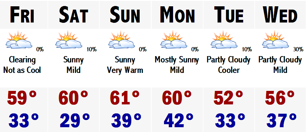 Say adios to the rain, wind, and cool temperatures for a while. After today's late November Nor'easter, amazing there was no snow involved, it looks like things will be on the upswing.
 It now looks like SNE is on the verge of another amazing warmup. Tomorrow with the storm departing, temperatures should respond nicely to between 55-60 degrees in much of SNE, exception will be Worcester, maybe only 50. If thats not a nice enough treat, wait until Saturday. There will be 100% sunshine and temperatures will be within a degree or two of 60.
Still not good enough? Well, then you will love Sunday. It should be mostly sunny again and highs should respond nicely up into the lower to middle 60's with dry conditions. No threat of rain. It will continue into Monday with highs in around 60. A frontal boundry will go throught the area Monday night-Tuesday and temperatures will "fall" to around or slightly above normal conditions. Mainly around 50. Wednesday southerly breezes will be back and highs should have no problem rebounding back well into the 50's. Right now it looks like Thursday of next week could be the warmest of the next bunch. Highs may be approaching mid-upper 60's. Its a long way out, so stay tuned.
FWI, parts of the DEEP SOUTH have already seen their first snow. Thundersnow was reported in Charleston, SC this past week. Snow accumulated up to 2" in Augusta, GA and snow was reportedly mixing in with light rain all the way down to the suburbs of ORLANDO, FL.
NOW TALK ABOUT WACKY WEATHER! A storm that brought SNOW to Orlando, FL is bringing ALL RAIN to New England.
Go figure.
Saturday, November 18, 2006
Playing it Conservative
 We finally had a normal November day around these parts. First one in quite a while. Tonight will be a quickie post, hopefully I can get a bigger one out sometime early next week. There is nothing to talk about and lots to talk about. The nothing part is the forecast for the next week. I guess it is good that there will be little "weather" across the nation this week as it is a busy holiday travel week. The one exception may be down on the SE coast, near coastal Georgia and the Carolinas. The coastal storm we have been advertising and barking about on this page, Eric, Ray and me, will develop. Just it will stay down there and crank up the wind, rain, and seas for them. It may try to come up the coast later on in the week and at this point with the GFS, it could throw a few rain showers on the Cape and the Islands by sometime Friday or heading into next weekend.
 Temperatures are on the downswing right now. Tomorrow will stay in the 40's and it will stay that chilly all the way until about Thanksgiving, as temperatures will slowly start to moderate, ahead of another storm that will likely cut to the west of us again, bringing in mild, rainy conditions later next weekend possibly, before cooling down again and likely warming up ahead of another storm upstream. The cycle continues.
Ray...thanks for stopping me getting carried away with the El Nino stuff and blaming the Nino for all of the warmth across the Lwr 48. Relative warmth that is. It is a variety of factors, but mainly whenever you get the jet stream slamming into the PNW, ie Seattle, storm after storm that pummels the coastal plain with inches upon inches of rain and mountains with feet upon feet of snow, it throws that mild Pacific air across the nation...limiting any cold air and any Arctic invasions. Until this stops, instead of getting Arctic Canadian cold we will continue to get "Polar" Canadian cold, which is not as cold/weaker, and does not last as long/modifies faster. In the next 7-10 days, I do not see this pattern switching all that much so, I am going with the "conservative" forecast of sticking with "What you see, is what you get." Once it switches though, OH, we'll know it.
PATRIOTS @ PACKERS Tomorrow 1PM
Kickoff: Partly Cloudy 35
Halftime: Partly Cloudy 37
End: Partly Cloudy 39
MY PRE-DICTION...PATS 27 PACKERS 17
Thats all for tonight.
Friday, November 17, 2006
Quiet Weather Dominates Into Next Week
 What a morning we had today. I woke up with my backyard totally under water and the temperature on my home thermometer read 68 degrees. SNE was warmer than most of Florida this morning, the exception was Miami where they were 69 degrees when Boston was 68. It was that tropical out there today.
It has cooled off and dried out a bit, the lawn is still under water and my neighbor is still pumping water out of his basement, but last night's amazing storm is the last storm we will see for a while, at least the next week.
This week looks to be tranquil and gradually turning cooler. Tomorrow should be in the 50's and then we will slip into the mid-upper 40's on Sunday with a slight, and I mean slight chance of a sprinkle or first flurry for any given area, excluding the Cape. Monday will be dry, but cool still with highs in the mid 40's. Tuesday, maybe a tad warmer in the mid-upper 40's. Then, it looks like the limited source of our cold air will be used up and the coolness will retreat and I see no reason why not to put temperatures back up into the 50's for Wednesday and see no reason not to go for a "morally perfect" high of 60 for Thanksgiving. Highs will likely be in the mid 50's, but chose to go with the 60 for a benchmark. People will remember a Thanksgiving at 60, better than the 50's. Some towns like Taunton, Carver, Norwood, and Bedford may come close to 60. Looking beyond Thanksgiving, we may cool down a bit going into next weekend, but there is no real cold air in Canada at this time, so I just can't forecast any long, prolonged cold air invasions that will lead us into December and the winter season.
The cold air is bottled way up in Alaska and the Yukon. Other places in Canada are not that chilly. Many areas near central Canada are just not that cold. Highs in the mid-upper 20's is not a cold source of air that can sustain itself over our area. It is not true Arctic air that can keep us cold and give us a chance at some white storms.
 This bottled up Arctic air may be a major sign pointing at El Nino and a mild winter. I am showing the warming water in the eastern Pacific in this map and it is showing a tell tale sign of the infamous El Nino. Warm water is starting to bank up against the northwest coast of South America.
 I am not ready to buy into this El Nino stuff quite yet and give up on this winter, but it is starting to become more and more evident that this just plain and simple may not be a snowlovers winter. Could this change? You bet, but its unlikely to reverse this type of pattern in such a short time to have a good snowy winter.
One thing is for sure. It sure felt like S-U-M-M-A-H this morning...INSANE WEATHER. If this morning was an indication of what kind of winter we will have...instead of getting the ski and snowboard ready, just invest in a pool, dig the hole and use it for seven or eight months out of the year. I dunno what to say.
LATAHH
Thursday, November 16, 2006
Windswept Rain Tonight
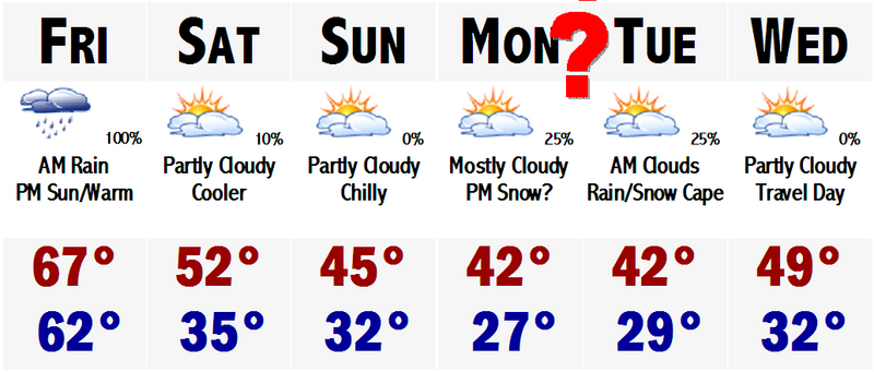 Its past the halfway point of November and we are still seeing temperatures near 70 in Taunton, MA. Here NW of Boston, it is currently in the mid 60's with Boston checking in at 68 degrees. Will this last? Well, for the next 24-30 hours, it will last. Tomorrow looks to be like another mild day with highs in the mid 60's after morning rain. Tonight we are under a FLOOD WATCH, everywhere except SE MA. Expect rainfall to be on the order of 1-3", possibly 4"+ tonight.
 There could be localized flooding during this timeframe as most of the rain will likely fall in a 4-7 hour time frame.
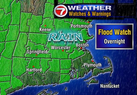
The link to the side is from WHDH BOSTON and shows just where the FLOOD WATCH affects. As you can see southeastern MA and southern CT is not under this FLOOD WATCH, but that does not mean that you will escape the rain. It just means that the heaviest, flooding rains, will probably not occur over you. Still, expect 1-2" of heavy rain tonight.
Looking down the line towards this weekend, Saturday, although cooler, still looks to be a tad above normal on the high temperature department. Highs should be in the mid 50's. Middle 40's are likely here Sunday and Monday. Then Monday night, there could be a coastal storm quite close to us at this time. It will be quite cold at this time with temperatures likely in the 30's. Computer models are showing that this storm system could throw some precipitation into eastern and southeastern New England at this time, possibly as a rain/snow mix. This is so far out, 4-5 days, and the track will likely change with each new run of the computer models which come out every 6 hours, that it is too early to forecast anything or side any which way. It would not be professional. But since this is not a professional site, I can tell you what exactly I am thinking.
I believe that the models will bring this closer and closer to the west, but then keep it far enough out to sea that it does not really have any effect on us here in Boston. Also temperature composites will likely come up from the borderline rain/snow line, safely above the critical 0 degrees C at 540 mb. So, expect a few sprinkles or a shower down on the Cape, perhaps just on the Islands.
Thats all for today...PEACE.
Tuesday, November 14, 2006
"Brighter Than Sunshine"
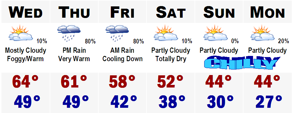
Okay. It is now the halfway point in November, Boston's gloomiest month. Well, Boston has lived up to that reputation the past few days with nonstop showery rains, fog, clouds, and drizzle. However, it has been unseasonably warm the past several days as well. Highs have been ranging from the upper 50's to mid and upper 60's. Averages for this time of the year should be around 52 degrees.
Guess what? Much of the same is forecasted for Wednesday and Thursday. Tomorrow there will be limited or no rain. We actually may see some sunshine and if we do, you guessed it, highs back in the mid 60's. If not, upper 50's to around 60 is all right too. Highs around 60 again on Thursday with another rainstorm moving in for the night. Looks like this will be an all night rainstorm with about another 1-2" throughout much of SNE. That will move out Friday morning and highs will be "cooler" still above average, in the upper 50's to around 60.
Even colder air will move in this weekend and early next week with highs in the mid 40's. Lows will get back down below freezing again. Upper 20's are likely again by Monday morning. Travel Day Tuesday, the 22nd, looks to be nice across much of the eastern U.S. A storm will be out to sea, which the track has been fluctuating, but current indications are that it will stay well out to sea.
Thanksgiving looks to be nearing the end of our mini "Cool Spell." Highs on Thanksgiving should range from the upper 40's NW to lower 50's down on the Cape. Gametime temperatures should generally be in the lower to mid 40's. Thereafter, it looks like the rollercoaster ride will continue as temperatures will be back on the upswing. Highs back into the positive range with highs back well into the 50's.
The next significant cooldown does not look probable until early December after the Thanksgiving mini cooldown. As you know, these weather patterns are very finicky, so please check back with Southern New England Weather for updates.
See you soon.
Monday, November 13, 2006
Gloomy Times...
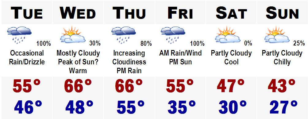
Gloomy times are here and here to stay they will. After a rainy and gloomy Sunday with both the Patriots and Revolution losing their games, Monday has turned out to be just as gloomy. Guess what? Tuesday promises to bring much the same with even more rain than we have seen today and yesterday. One good thing is that the rain will quit on Wednesday and if we see some sunshine highs could rebound all the way into the middle 60's.
Same in the temperature department for Thursday, mid 60's, but rain will be developing during the afternoon for more gloomy times. Rain will continue into Thursday night and early Friday morning with perhaps another 1-2" of rain after Sunday's inch and tonight's inch.
Thereafter, the sun will return! However, highs will struggle to manage 50 on Saturday and we will likely be in the lower to mid 40's on Sunday.
Sticking my neck way out there, it looks like the two busiest travel days, Monday and Tuesday will be nice around here, but cold with highs in the lower 40's. We may have to be watching a storm to our south, but at this point all indications are that it will go out to sea. Thanksgiving for all the football games looks to be chilly in the morning with temperatures generally around 35-40 degrees from about 10-12PM.
Let's get through this gloomy week and then next week is a break...THANKSGIVING and then the fun really starts with HOLIDAY SHOPPING.
Wednesday, November 08, 2006
Borderline Rain/Snow Event Sunday
You heard it here first. There is the possibility of some snow around these parts this coming Sunday. Right now it is a very borderline event...could be rain could be snow.
First, after today's wicked rains, 2"+, tomorrow through Saturday will be absolutely perfect November weather. Highs tomorrow will range from the upper 60's to lower 70's. It will be a tad cooler Friday, but highs still should get into the 60's and we are back near or over 70 for Saturday, each day with sunny skies.
Then comes the fun....
A storm system will be coming at us from the west, northwest. It will have ample moisture, approaching one inch of liquid. There is no doubt that the first half of the storm will be ALL RAIN for all of New England, but then during the day on Sunday, cold air will be trapped into the storm and whatever leftover moisture is here on Sunday morning it will likely be snow, not rain. Obviously the higher in elevation you are, the better chance you will see the snow.
So, right now I would say that the chance of seeing snow here Sunday ranges from 20% in Boston, S&E, to 30% in Boston's NW suburbs, to 50% in the Worcester Hills, to 60% in southern New Hampshire.
We'll see...
Monday, November 06, 2006
PUSHING 70 BY THURSDAY?!!
First, I would like to just let the readers know that north-northeastern Maine saw its first accumulating snow of the season this morning with the passage of a warm front. Winter Weather Advisories were hoisted for much of the inland part of the state north of Bangor. Generally 1-3" of wet slushy snow accumulated, but it signals the rapid encroachment of winter onto the six state region. I would say that in about 3-4 weeks, I will be making my snowfall accumualtion maps for our area around Boston.
Little did we know entering this month on such a cold note that we would be talking about warm air so soon. After seeing the past several days with highs struggling to get out of the mid 40's with lows at night in the low 20's, the warm air is on its way back to New England.
It will come with a payoff though. Rain is in the forecast for Wednesday, basically calling for on and off rain all day Wednesday, mainly a showery rain, with highs approaching 60. Then comes the "tricky" part, the forecast for Thursday.
The key to hitting 70 is clearing out the rain in the early morning hours and having sunshine break out by late morning, warming us all the way until 4 o'clock. If this happens, it will feel downright SPRINGLIKE! Highs will easily push 70, and places like metrowest, Boston's immediate suburbs, could top out in the LOWER 70's. Yes the lower 70's. This amazing warmth will not last long as a cool front will move in through the area Thursday night bringing us back into a somewhat sense of reality. Highs on Friday will stay in the lower to mid 50's with partly cloudy skies. One thing that is unique with this cool front is that behind it, there is no bitter arctic air from Alaska or Alberta.
Nope that is not where this air is coming from. This air will be coming in from good old rainy Seattle, WA. We will be entrenched in a west to east Pacific flow of air. This means that the country will generally have fast paced storm systems hitting once to twice a week with mostly rain, even to the far north. The exception in our area may be the highest peaks of VT, NH, and ME. Other than that, it looks like the next 10-14 days look to be on the mild side for much of the region.
This upcoming weekend looks to be fairly nice with a mainly sunny sky Saturday with a slight chance of a passing shower or two Saturday night before more sunshine and seasonal temperatures for Sunday. Saturday and Sunday should both be in the 50-55 degree range. Beyond the upcoming weekend, looking beyond the 7 day forecast, it looks like the Pacific air and pattern will dominate much of the lower 48 states, with no intrusions of frigid arctic air coming down.
Beyond November 20th, the week of Thanksgiving, we may be singing a different tune, just a heads up, but until then enjoy this treat we are getting before our New England winter really settles in.
SIDENOTE: The seven day forecast graphic will be available again sometime this week again...
Thursday, November 02, 2006
Are We In Store For a Warm November
Current projections show this November, at least the first half of it, to be quite warm from coast to coast and from border to border. The exception will be the next 4-5 days of temperatures in the 40's here.
Thereafter, I believe we will be seeing crazy high temperatures and no snowstorms at all in the lower 48. More on this developing story later.
Thereafter, I believe we will be seeing crazy high temperatures and no snowstorms at all in the lower 48. More on this developing story later.
Monday, October 30, 2006
Have a Happy WARM Halloween
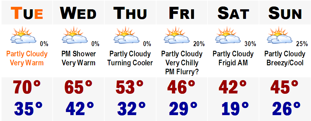
Amazing. I cannot believe it is already that time of the year again. Happy Halloween. I hope everyone has a safe and happy Halloween. Tomorrow will be a great night for trick-or-treating. After having highs around 70 degrees around 2-3PM, temperatures will slowly drop through the night. Here is a time by time breakdown for all you trick-or-treaters and parents.
4:00 PM....Mostly Sunny Mid 60's (Sun setting at 4:38 PM)
5:00 PM...Dry Around 60
7:00 PM....Dry Mid 50's
9:00 PM...Dry Lower to Mid 50's
12:00 MIDNIGHT....Dry Upper 40's
After that, you are on your own.
The warmth will continue into Wednesday the first of November, but then a surge of new cold air will move into the area later this week, especially Friday with highs in the lower to mid 40's throughout the weekend. There is even an outside shot of some SNOW FLURRIES in the air Friday night in the Boston metro area. Right now, I would say the chance of snow Friday night is at best 15-20% right now.
Temperatures will slowly moderate ending off the weekend and heading into early next week. Talk to ya'll later.
Friday, October 27, 2006
Rain Rain Rain
Rain and plenty of it is in the forecast for tomorrow. A good 1-2" is likely throughout SNE with isolated amounts possibly over 3". So tomorrow will be a washout, plain and simple. Sunday and Monday will be seasonably cool with highs in the mid-upper 50's.
Halloween will be great with highs in the middle 60's. Don't get used to it though, by the end of the week, we will be back into the grips of autumn with highs struggling to get out of the 40's.
More later.
Halloween will be great with highs in the middle 60's. Don't get used to it though, by the end of the week, we will be back into the grips of autumn with highs struggling to get out of the 40's.
More later.
Monday, October 23, 2006
Cold Times Ahead...
 Colder than usual times are ahead this upcoming week. Tomorrow will be cool with highs in the upper 40's to around 50. The same can be said for Wednesday and with more sunshine on Thursday, highs could rebound back into the low-mid 50's, more seasonable for late October.
 As this is going on, a storm system will be moving in on us from the southwest. It should cut to around Pittsburgh, PA, bringing in a shield of rain with snow mixed in on the northernmost edge into the mountains of northern New England. A secondary low will form off of Cape Cod, bringing in cold air into the storm even more and this could yield to accumulating snows for much of northern New England. Still to early to speculate, but some areas, especially elevations higher than 1600' could see in excess of six inches of snowfall.
Southern New Hampshire and Vermont could even see some snow mixed in with the rain Friday night. The Worcester Hills could see a few flakes as well. It all depends on how hard the precipitation falls. If it falls heavily enough, it could bring cold air down from the storm, turning the rain over to snow. Needless to say, it could get interesting around here on Friday. Thereafter, expect chilly conditions and on Sunday, we could see a few passing flurries, even down to the coastal plain with highs in the mid 40's.
More on the forecast later...and on a side note...the tropics are gurgling in the Pacific. Hurricane Paul now has winds of 90 mph and Baja California is currently under a Hurricane Watch and will likely bear the brunt of Hurricane Paul. Tropics in the Atlantic continue to be absolutely quiet.
Wednesday, October 18, 2006
A Warm Thursday
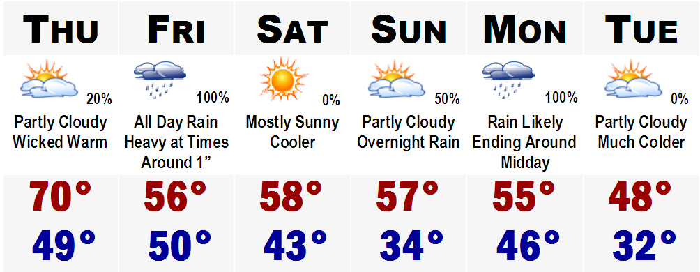
Here is a quick look at the five day...
I'll have a little more indepth post later in the week...but right now I'm loaded with work.
More later.
Subscribe to:
Posts (Atom)