Wednesday, January 30, 2008

Winter, What Winter?

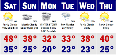
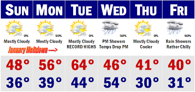
Who would have known that the snowstorm on the Cape would be the last one we would see for weeks. Basically, if you missed out on that one, you will probably go a good month in between significant snows. For the entire region, the last significant snow occured on January 14th. We may have to wait a while to see another good sized storm. It seems like a more favorable pattern is always seven to ten days away, but thats it. That favorable pattern for cold and snow seems to want to stay in the not too distant future and not occur. We are briefly going to go to a cold shot that will only last 18-24 hours before relaxing. Tomorrow will not be cold, but chilly with highs seasonable, in the upper 30's to low 40's. Then we get into some rainfall on Friday, a rainy day, with temperatures in the mid 40's. We stay warm this weekend and continue the warm pattern into next week with highs generally in the 40's and 50's. We may have a rainy 'Super Tuesday' (perhaps "Super, Super") with highs very mild with highs pushing 60 degrees perhaps. So you will have no excuse for not voting on Tuesday. We may start to cool down later next week, but there are no signs of any real deep settling cold into the Northeast for the foreseeable future. More like quick-hitting cold shots that last a day or two and move on out.

February is quickly approaching and I thought I would put out an outlook for the 'snowiest' month of the year. This year doesn't look to provide the whallop we usually deal with, though, so for non-snowlovers, this is your month again.

FEBRUARY OUTLOOK FOR BOSTON AND ITS SURROUNDING SUBURBS_______

Boston....February 1st 37/22

Boston....February 29th 42/27

The average snowfall for the month is around 12.7 inches, coming in as the snowiest month on record for Boston. Many powerful Nor'easters are common during this month. We may remember the Blizzard of '78, the President's Day Blizzard in '03, and the President's Day Blizzard II in '05. This is the month in which we usually get our largest snowstorms. However, this year looks to be a lot more tame compared to past February's. Daytime average highs come up as well with the warmest temperature on record at 70 degrees. However, we can still get some of the harshest cold air the Arctic can deliver with the record low for the month at -18 degrees. So keep the shovel handy this month, but know that the light is at the end of the tunnel. Only about 6-8 more weeks of wintertime weather.

Nearby Suburbs....February 1st 36/16

Nearby Suburbs....February 29th 41/21

Spring is coming right around the corner, but this month still reminds us that we are in the grip of old man winter. Snowfall for Boston's nearby suburbs usually averages around 20 inches for the month. We pick up some of the biggest snowstorms this month as in the Blizzard of '78 when many suburbs picked up 2-3 feet of snowfall. Spring warmth will try to make its way to New England this month and severe weather will be common in the Southern US. Its a temperature of extremes and BIG STORMS. Watch out!
Tuesday, January 29, 2008

Rain, Rain, and More Rain

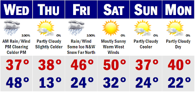
We have definitely gone into a warmer pattern for January this year from our cold and snowy December. Our 'warm' and rainy January pattern will persist through the rest of this week and even linger into next week as well. We have ourselves a rainstorm for all coming up tonight even up North. Rain will be heaviest tomorrow morning during the morning commute. Temperatures will start in the upper 40's to around 50 during the morning, but a strong cold front will move through in the afternoon and temperatures by the evening commute will be falling through the 30's and 20's. This won't set up a frigid Thursday. In fact, Thursday will be above normal again, leading to our next wet storm with some ice possible out past ORH county and central and northern New England could see more in the way of snow and sleet, but here in SNE, it will be mostly a chilly rainstorm. It won't be so chilly on the Cape where much of your 8-14" snowpack will vanish with tonight's mild rains and Friday's storm as temperatures could come up over 50 degrees. Saturday will likely see temperatures very mild with a downsloping westerly wind, so temperatures will be in the mid 40's NW and around 50 at the east facing coasts. Then we slowly start to cool, but will still be above average. All and all, a very uneventful week for snow lovers the next 10-14 days. Check back after Februrary 8th, as by the 10th of February we could go into a more favorable pattern for cold and snow. Until then, see ya.

Saturday, January 26, 2008

First and Final Call

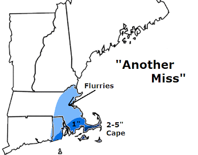
Another storm and another miss on the way for SNE, most of SNE. The Cape and Islands look to be barely grazed by this storm system tomorrow night - Monday. Yesterday at this time, it was looking like 1-3 feet of snow was likely for much of eastern SNE and trending more and more, but we came back to reality later last night and now this storm looks to be another bust. I have an area outlined in eastern Mass and most of RI that could see some flurries, mainly associated with the northeasterly wind that could bring in some moisture off the ocean tomorrow afternoon ahead of the actual storm system. Then as you get to extreme far SE MA, then you could get to an area of about an inch of slushy mess south of Plymouth. That sloppy inch may make it up to say Bridgewater, but that would be about it. The Cape and Islands will be the 'bread winner' with this one. I'd say 2-5" is possible down that way as they will be closer to the storm, but marine air may move in and change them to mostly rain which could limit accumulations. Nantucket could see over 6" of snow still, but for now I am playing it conservative. Most computer models are going for a mainly out to sea solution right now with a few of our less reliable models still getting that heavy band of snow all the way to Nashua, NH. However, this looks extremely unlikely ATTM. No luck with this one and the next one looks to be a mainly rainstorm by Friday, sorry. We have two that go out to sea and then we get one to head to our west. Just frustrating if you ask me. That's it for now. Will update if a miracle happens, but looks highly unlikely.

Wednesday, January 23, 2008

"Wide Right"

UPDATE 4PM: Okay, the GFS and NAM have been painting us to have some snow showers tomorrow afternoon and night as an inverted type of trough tries to throw some snow into eastern Massachusetts and Rhode Island. The 18z NAM just came out and is probably overdoing it, but throws a band of snow from the Cape up into southern NH that drops between 0.1" to 0.25" of QPF from Plymouth to Manchester, NH, not making it past the eastern suburbs of Worcester. Given, thats a 1-3" snowfall with ratios of 20:1, that could be a sneaky 2-4" event for eastern SNE. It paints over 0.25" on the Cape and Islands, so they could see closer to that 2-3"+ type of fluffy snowfall with ocean enhancement and ocean effect keeping the snow going down there for a few more hours. I would not be surprised if a place like Chatham or Truro, MA wound up with 4-5" of pure fluff with liquid equivalency of 0.2" to 0.25"; that would not shock me at all. For now, I want to see the 18z GFS come out and see if it comes in with a similar idea, likely less agressive than the NAM, but will make me look at it nonetheless. For now I will go for 1-2" of snow on the South Shore and Cape, but want to stress that the outer part of the Cape could see more like a 2-4" event, by the way it looks right now. For the rest of us from Boston point north and west, I am going for mainly snow showers with a coating possible. This will extend into RI and western MA and southern VT and NH. A coating is possible in these areas, but the best chance of seeing snow will be the farther south and east you come. This could be one of those storms that kind of sneaks up on us last minute, so stay tuned, I still don't think it will be that big of a deal, but fun to watch nonetheless.

2PM UPDATE We will be on the edge of a gigantic developing ocean storm tomorrow with mostly cloudy skies and a few flurries around in the air tomorrow. If the pattern was a little less progressive, we would see the storm develop nicely near the Del Marva and shoot northeastward to give SNE a nice dumping of snow close to a foot. However, with our grossly progressive pattern with zero blocking, this storm will develop too little too late and head harmlessly out to sea and give the fish a whallopping. Areas that may see a finger of snow as the storm develops would be southern NJ and DE. Here, they could pick up a quick 1-3" of snow before it rushes offshore. The Cape and Islands have an outside shot of seeing up to an inch of snow tomorrow night as the storm blows up SE of the benchmark. This will usher down some real chilly air for Friday as temperatures will stay in the mid 20's with a biting wind.

Moderating temperatures will be the rule on Sunday with highs getting back into the middle 30's. There is an outside shot of some light snow or flurries on Saturday night, but that would not amount to anything, so don't worry about it. We continue to warm up heading into next week with temperatures in the low 40's on Sunday and higher yet on Monday and Tuesday as an ocean storm misses us again, but it would have been all rain anyway, so no worries there. Temperatures will be pushing 50 degrees come Tuesday and we will see our second mini January Thaw to end out the month. We should see a 3-4 day window with temperatures in the +10 to +15 degree dept. from normal daily highs. Then we get colder, but doesn't look all that bad in the long range or good if you like snow. It looks like we will have to wait for a block to develop over Greenland before we can really start to talk about any significant snows. December was pretty much a lucky month with no persistent block, just one storm after another that took the perfect condtions to get SNE seasonal snowfalls up to the 35-50" range thus far. January hasn't been that good at all, barring that storm last week that dropped a widespread 6-12".

More on the forecast tomorrow.

Monday, January 21, 2008

Light Snow by Tomorrow Afternoon...

Not going to go into much detail at all with the forecast for tonight. I am pretty much going to keep my forecast from this morning with the snowfall accumulations for SNE. Max area of snow will come to 1-2" of snowfall. I think the max of 2" could come in Worcester County and western CT. That is about it. Closer to Boston, it will be generally under one inch. That will wrap up by later tomorrow night and we will see a seasonable Wednesday with highs in the mid 30's before our second Arctic blast on Thursday with a period of light snow possible across the region. Highs will be in the low 20's. There will be no snowfall accumulation by the way it looks right now. Maybe up to an inch if all things play out well. That will chill us out on Friday into the teens. By like clockwork, the next storm comes and we warm up just enough to have rain/snow problems again by Saturday.

Overall an active week, but I don't think there will be much shoveling around here this week.

Not a Big Storm, but Problematic Nonetheless

This is not going to be a storm that goes down in the record books. It will, however, be enough to mess up the latter part of the evening drive. A snowy/sleety mess should push into SNE sometime after 3PM and only last for about a six hour period. Right now I don't think anyone will see over 1-2" of snow, with an isolated 3" amount over the Litchfield Hills or our Worcester Hills. That 'heavy' band will move into the northwestern suburbs of Boston as well, with Boston seeing mostly a rain/snow mix that doesn't accumulate. South and east of Boston there won't be much of anything. Probably some wet snowflakes at the onset and final minutes of the storm and then its over for you. South Coast, Cape and Islands, nothing but rain. So its not anything to write home about, but I wanted to mention it because it will be snowing tomorrow night and didn't want to have everyone totally off guard. More tomorrow, now back to studying.

Wednesday, January 16, 2008

Friday Morning Mess

10PM UPDATE: Here is the update within hours of the snow's arrival into the Boston area. I just wanted to post the radar map from Accuweather that shows a healthy swatch of snow developing in NW New Jersey and heading into Connecticut and western Massachusetts. Right now the snow is on Worcester's doorstep and should be encompassing the Boston area by 11PM. In Boston proper, it should start as some big wet flakes before quickly changing to rain as they are already up to 34 degrees with a wind off the water. Just inland, temperatures are in the 29-31 degree range, so there will be some accumulation as close as Cambridge. The storm has overperformed in the Mid Atlantic, giving the Baltimore, MD area a good 3-5" snowstorm. Even DC got a couple sloppy inches of snow from this one with areas northwest of these cities getting between 6-8" of snowfall. This band will move through tonight and many will stay snow through the early morning hours and I am keeping with my call from last night. A regionwide 1-3", not Boston, but tonight, I want to mention that areas north and west of Worcester to Nashua, NH could see up to 4-5" of wet snowfall. Here is where I think a few school delays or closings will be possible. Closer to Route 128, a good 1-2" of snow is forecasted with nothing for the city. Maybe a skim coating over to pure rainfall and temperatures in the mid 30's. More on the storm tomorrow morning as we assess it.

UPDATE ON FRIDAY STORM: It now looks like colder air will get involved with this storm system and give all of SNE a period of snow, except the Cape and Islands for at least a little while overnight Thursday and early Friday morning. It will be a fast moving period of precipitation that will likely move into the Boston area around 2AM Friday morning, earlier south of here. It will start as snow for everyone and then quickly change to rain along the coast, including Boston and inside I-95. We will probably see no accumulation on the light blue area, just the fact there will be some wet snow falling before the swich to rain. Then in the darker blue is where most of SNE will fall. Here is where a longer period of snow, likely 2-4 hours of moderate to heavy snowfall that could deposit a quick 1-3" before a switch to rain inside of Route 495 and maybe some freezing rain in Worcester County and into southern NH. Where it stays all snow in northern New England, a quick 3-5" of snow will fall in about a six hour period from Friday morning, ending early afternoon. The precipitation will taper here in the Boston area between 10-12PM. Not a big deal, but enough to maybe cause some delays for your Friday morning commute. Nothing like this past Monday. End of the weekend still looks to be on track for bitter air with temperatures in the teens for the Pats AFC Championship game against the Chargers.

Tuesday, January 15, 2008

Rainstorm Friday to Coldest Air of the Season

We have really nothing going on this week. Tomorrow and Thursday will be typical mid January days with highs in the low 30's with some sunshine and clouds and light winds. Morning temperatures will be in the teens regionwide. Then we watch the Gulf of Mexico that will throw a storm at us later Thursday that may start as a very brief period of some snow. That will quickly change to sleet and then rain here in SNE and we will be seeing plain rain for the morning commute on Friday morning. All the snow will be confined to northwest New England where a few to several inches is not out of the question. It may be heavy at times until about midday before we clear out later in the afternoon and wait for an Arctic front on Saturday that may spawn a scattered flurry or squall later Saturday, before Sunday will be the coldest day in over a year. Highs on Sunday may not get out of the single digits. Morning lows on Sunday and Monday will be below zero. It will be battery killing cold later this weekend and early next week. We should moderate as the week progresses, but still be pretty chilly.

Early call on the Pats game at 3PM Sunday looks to be very cold with gametime temperatures around 10 above and windchills likely below zero under mostly sunny Arctic skies. Dress warm if you are lucky enough to go to the game. Another AFC Championship on its way to New England after last years flook with Indianapolis.

Monday, January 14, 2008

One Down, Another on Deck

I hope you are getting all your shoveling done with this past snowstorm. It did not pan out just as I'd hope for many areas, basically everyone got low ends of my ranges or even less, but it was still a very heavy snowstorm. In general it was a 6-12" snowstorm for SNE with isolated amounts of up to 14-15". The South Shore and Cape did not fair as well with only a coating down there as the low departed. This storm is pretty much done, just the Heavy Snow Warning goes for the coast until 3PM. Again, heaviest of the snow was in Worcester County where up to 15" of snow fell. Now we look to the next storm and it looks like this one will be a mainly rainstorm for the folks that got blasted with this latest round of winter weather. The snow will be confined to the mountains of CNE and NNE. Here is where there is the potential of seeing over one foot of snowfall. This would be in VT, NH, and ME. Boston looks to be all rain with this one with the area of low pressure tracking up the Connecticutt River Valley. I could see Albany, NY getting whalloped with several inches.

JANUARY 14, 2007 SNOWFALL TOTALS

Royalston 14.5"

Athol 13.5"

Leverett 12.0"

Millbury 11.8"

South Hadley 11.5"

Southwick 10.5"

Topsfield 8.5"

Woburn 8.0"

Georgetown 7.0"

Rockport 7.0"

Boston 6.4"

Worcester 6.2"

Providence 4.5"
___________________________________________________________________

That's all for now. If you are a student, I hope you enjoyed your snow day...back to school tomorrow.

Saturday, January 12, 2008

UPDATE: Final Call; Major Monday Nor'easter

SUNDAY AM UPDATE: I have upped totals for many areas. I upgraded extreme northern New England by a few inches. Also, I pushed the 8-15" amounts down to the Cape Cod Canal where I think eight or so inches of slop is not out of the question. Most notably, I have raised to heaviest area of snow to 12-20". This storm is looking like it will be a one in a few years storm here in the Boston area; a classic Nor'easter. The one thing that does not look that bad with this storm will be the winds and the coastal flooding. Winds will gust to 40 mph along the shore during the storm and coupled with a new moon, there won't be much coastal flooding with this storm. Maybe a little splashover for folks along the coast. The big story with this storm will be the snow and the duration of the storm. It will start after midnight tonight and not end until sometime after the evening commute and even after that there will be bouts of light snow all the way through most of Tuesday with a clipper system. So you can bet it will be a very wintery week. Watches are up for all of New England and we even have warnings up for CT, RI, and south of the Mass Pike now. All these watches will turn to warnings later this afternoon, as its just a formality to wait. Go to the supermarket today for milk and bread and an extra shovel if you need one and then sit back and watch the snow fall from the comfort of your home tomorrow.

SATURDAY PM DISCUSSION: Here is my second call for the Monday storm that I have been beating to death the past few days. I think I have pegged where that heaviest band of snow will develop. It will develop in an area where the most people live. It will set up shop from Hartford to Worcester to Boston to Portsmouth, NH and south of Portland, ME. Here is where I think the heaviest snow will fall. A general 10-18" of snowfall, major crippling accumulations on the high end. Right now if I had to peg a spot for seeing a lolly-pop 18-20" total accumulation I would say Northern Worcester County to southern NH. For most of New England outside of the heaviest band, a general 8-12" looks good. This will encompass Plymouth, MA northwestward. Western Massachusetts will also be in this band of moderate to heavy snow amounts. Central and northern New England will see this as well. This will be very good for the ski resorts as many have been reporting icy conditions during the past few days because of the mild temperatures and rainfall. If you go on the South Coast of RI and north of the Canal to Plymouth, this is where I think there could be a period of mixing with some rainfall, which will hamper accumulations and make for a heavy wet snowfall. A good 3-6" is plausible here. The same can be said where you are removed from the storm in extreme northern New England and western Maine. The Cape will now see mostly rain from this mixing with snow and sleet at times before ending as a period of snow towards the end of the storm. Therefore, I will go for a general 1-3" down on the Cape and Islands because of the mainly rain solution. I am liking this map and will keep it as my final unless it looks like this storm will really change course, which looks unlikely ATTM. Its going to be a major Nor'easter folks. Boston is going to get dumped on!

More later tonight should there be any updates and will have all the latest on the watches and warnings that will likely go up tonight or tomorrow morning and afternoon. It will be a wild ride.

Calm before the Storm

Today will be a very nice day with highs getting back to over 50 degrees across SNE this afternoon. Boston is already starting off in the right direction with their 8AM temperature in the low-mid 40's. We will easily see highs come up to between 48-53 degrees this afternoon, warmest in the immediate suburbs of Boston away from the water. You would not know that a huge monster storm was on its way if you just judged by today. Oh, but there is a monster on the way to most of the Northeast from Philadelphia to Downeast Maine and everyone in between. Tomorrow the storm will be in its infant stages off the SC coast, gathering steam. We will already begin to see high cloudiness later tomorrow morning and the clouds will thicken to a dark overcast by later in the afternoon. The winds will be eriely calm tomorrow as well, before all is let loose on Monday as a raging Nor'easter gets cranking over our area.

Monday will just be a bad day pretty much from start to finish, by the way it looks right now. Heavy snow should have swept into much of SNE during the predawn hours of Monday and the heaviest snow with this storm looks to be from 8AM to 2PM. Here is where I think we will experience our heaviest rates, between 1-2"/hr, maybe a little bit more if some impressive banding develops with this storm, then we could be seeing 3"+/hr snowfall rates with thunder and lightning. Winds will be very strong out of the NE with perhaps wind gusts as high as 50-60 mph, especially along the coast. The Cape is the wild card ATTM, where I think they will spend a large duration of the storm as wet snow/rain. However, I think if this storm gets cranking strong enough, I would say the inner Cape has a chance of seeing heavy accumulating snowfall. The Islands and the outer Cape may have a tough time accumulating more than a couple inches. Nonetheless, I think this all should start to wind down sometime before the afternoon commute, if there is one because I know a lot of people will stay home with this one and that is the smart thing to do.

As for snowfall accumulations, I pretty much like my map from yesterday. I think that area in dark blue will have the heaviest accumulations, but there will be a narrow band setting up with this storm that will dump closer to 14-18" of snow and that could set up right around Boston and its surrounding suburbs. Even up into SE NH could see easily over a foot with this storm system. I'm going to hold off on making my second call until after I see the 12z suite, but thereafter, I will start planning out my second guess. This one could be a doozy.

Later next week, we stay seasonable, mid 30's, before our next chance of a wintery mix. Right now I would favor a mostly rain solution from the Friday storm with snow confined to western and northern New England, ATTM. Things can change that far out.

Friday, January 11, 2008

FIRST CALL: Biggest Storm of the Season?

Here is my first call for the possible major Nor'easter for New England on Monday. The range of these snowfall contours could still change by say 50 miles either way, but I am becoming confident that the heaviest snow will fall in the corridor from Hartford to Worcester to Boston up past Manchester, NH and Portland, ME. Here is where I think a general 6-10" of snow is possible with a few 12-14" lolly-pops here and there. Even areas on the South Shore should stay mostly if not all snow and see between 4-8" of snow and right now I am leaning towards the higher amounts on all my ranges for SNE and Downeast Maine could be seeing close to 15-20" of snowfall with near blizzard conditions later Monday and Monday night. The Cape is of course the wild card with perhaps 3-7" of snow, less if it mixes with more rain and more if it stays snow. I could see the outer Cape getting 2-3", while if you move towards Falmouth or Wareham, you could come closer to 5-7". These details will be ironed out later. Right now, all I will say is that a major storm is now likely around here on Monday. School cancellations look likely ATTM with a hectic AM commute in the heaviest of the snow.

Big Pats Forecast, Stormy Monday Likely

Finally the models are starting to come to some sort of agreement this afternoon. It is looking more and more likely that we will have a winter storm here for New England on Monday, Sunday night into Monday, ending sometime Monday afternoon. It looks at this time to be a moderate snowstorm. If I had to put some numbers to my thinking right now, I would say a regionwide 4-8" is possible, with less on the Cape, but its so early they have just as much of a chance as Boston to see upwards of a half foot of snow. The computer model that I trust a lot at this timeframe is the GFS and SREF's. They are usually very good and are showing a dumping for our area. Still way too early to peg numbers, probably will wait until a couple hours before the Pats game to put out my first forecast on snow amounts. It should be a regular Nor'easter, with gusty NE winds, may cause coastal flooding, but astronomical high tides will be low-moderate as it will be a half moon. Still too early to peg details with this storm just yet as placement of the LP is still too hard to peg ATTM.

To get there, tomorrow will be a warm day before we return to reality on Monday with lots of shoveling. It will be semi-cold next week and maybe we will get back to 40 degrees by Thursday, but by the end of next week, the other shoe will drop and we will be back in the 20's for highs.

Patriots Forecast
8:00PM Kickoff

Patriots (16-0) v. Jaguars (11-5)

Kickoff: Mostly Clear, Light Winds; 38

Halftime: Mostly Clear, Light Winds; 35

Final Seconds: Mostly Clear, Light Winds; 32

_____________________________________________________________

That's all for now. I will have more on the potential winter storm later this weekend. Have a nice weekend and GO PATS!

Thursday, January 10, 2008

Rainy Friday; Watching Early Next Week

Nothing has changed in the forecast from yesterday's discussion. Rain is still slated for our area tomorrow and will amount to around an inch for many in SNE. It will start as sleet in central New England, but even there should change to rain during tomorrow. Highs tomorrow will be in the 40's in SNE, but the Cape could get into the warm sector and see highs over 50 degrees, for another balmy day. Tomorrow will be a windy day as well. Saturday is still very mild and then we finally cool down for Sunday before the infamous, uncertain storm for early next week. Changes from yesterday is that I am becoming more confident that this will effect SNE in one way or another. However, how it affects us is still uncertain. The models are starting to come to some sort of an agreement, but still not good enough for me to put out a solid forecast just yet. By tomorrow, I think I will be able to make a more concrete or say clay forecast, that will still probably change in small details, but by this weekend, things will start to be etched in stone. Thereafter, it stays seasonable through the rest of next week, before it gets stormy again later next week, perhaps.

Wednesday, January 09, 2008

WACKY COMPUTER MODELS: Next Week's Storm Uncertainties

Today was another day of highs over 60 degrees. Two days in a row of unseasonably warm weather here in SNE. Yesterday Boston hit a record of 67 degrees, while today this were one degree shy of a record at 63 degrees for today's high temperature. We will not get back to this level of warmth tomorrow. Tomorrow will be more like 50 degrees for a SNE high. Some places may make mid 50's but that would be about it. Then we cloud over tomorrow night and the heavy rain commences for Friday morning. It will be a very wet morning. All said and done once the rain tapers late Friday afternoon, a new 0.5" to 1.00" of rain will have fallen, wiping out any snow that you may still have in your backyard leftover from the incredible warmth. Then we stay rather mild for January on Saturday, mid 40's, before we finally start to cool down on Sunday.

That storm discussion is going to have to wait until the computer models start to show some agreement. Right now they are all over the place. One computer model takes the storm west of Boston and is trending NW, while others are still keeping the storm really weak and just dumping the batch of precipitation out over the Atlantic off the SC coast and never gets its act together or any amplification. Needless to say, one reliable model has this thing traveling so far S&E that we would see partly cloudy skies, while another brings it so far inland that we would see some brief snow/mix to rain and mild rain at that. Its about a 400-500 mile difference in storm tracks only five days out. Not very good and why talk of this potential storm would be irresponsible at this point in time. I hope that later on we will start to see agreement with this wacky computer models one way or another so we can start to make a forecast with some confidence. Right now I have very little confidence with this forecast. Hopefully, in a good world, by 12z Friday we will start to see some congruety. This weekend, namely Saturday should be a day when the models will be locking into their final solutions. Check in then for an official forecast regarding this storm.

Hopefully I can say more about it tomorrow. That said, there is a weak clipper that will be moving through the Ohio Valley later on and could bring a round of light snow north of the Pike on Tuesday. Thats so far out that I won't say more than that.

Until tomorrow.

Tuesday, January 08, 2008

Record High Set in Boston Today

Today was more of that of the weather we experience in early May! Highs today around SNE got into the mid and upper 60's. Boston set a new record high, shattering the old record of 64, with a new daily high of 66 degrees. The snow was melting really fast today, but I still have most of the snowpack in my yard, still a good 3-6". Melting will continue for the next 48 hours, coupled with rain tomorrow, most spots will start to go bare tomorrow and if not tomorrow, Thursday. This snowpack under 10" doesn't have a chance. Friday will be another rainy day with over one inch of rainfall possible, which will wipe out most of our snowfall. It may not be gone for long though as we will start to cool down this weekend, back into the mid 30's on Sunday, and then Monday we watch towards the south and watching a possible storm that could affect our area. Its still six days out so we will just continue to watch it. I won't go into anymore conversation about this storm threat. Just stick it in the back of your mind with all the other important stuff, like when to pick up the kids from practice, what to make for dinner, and other important stuff.

Thats all for today, nothing more to really talk about. Get outside and enjoy the warmth!

Monday, January 07, 2008

Record Warmth Tomorrow

Little in the forecast has changed. We are pretty much locked in to a really warm Tuesday. Tomorrow will feel like mid-late April with highs in the lower 60's in SNE. Many towns will come over to 60-62 degrees for tomorrow. That will set the stage for a very warm Wednesday morning with lows staying between 45-50 degrees, so you can bet that there will be much melting of whatever is left on the ground after tomorrow's blowtorch. Wednesday will start rainy and gradually clear later in the day. Early morning temperatures up until about noon will come up to between 55-60 degrees. Then they will start to come down later in the day. Thursday will be cooler, setting the stage for a cold rainstorm on Friday. Temperatures across New England will be in the 30's, so that will save NNE of seeing any catastrophic or even major flooding, where snowfall depths are still in the 10-20" range. We have a mild Saturday until we start to cool down later Sunday, back to the mid 30's.

Saturday, January 05, 2008

Record Warmth Tuesday?!

Not a big discussion tonight. Everything is pretty much going in line with what I have been saying all along. We will really torch tomorrow through part of Wednesday, before we cool down with a cooling rainstorm. Then next weekend we could be dealing with a cold rainstorm again. Record highs are possible on Tuesday. The record for Boston is 64 degrees and I think Boston will come mighty close.

Friday, January 04, 2008

Sayonara Cold, Welcome Warmth

Today was the last day we will have for a while that features temperatures below 32 degrees. Many spots only managed highs in the upper 20's to around 30 this afternoon, but this cold will soon be a thing of the past. Tomorrow will feel like spring with temperatures getting all the way up to around 40 degrees, after balmy morning lows up into the 20's. Sunday is a step in the right direction with about a ten degree swing warmer. Temperatures on Sunday will be getting up to around 50 degrees. All of this warmth will be done with partly cloudy skies, so we will actually be able to enjoy this abnormal warmth in January outside instead of watching it from the window because its raining. It will rain next week, but not until say Wednesday night or Thursday, but before that we get really mild around these parts and on Monday, we are appoaching 60 degrees in the Boston metro area. You think that is warm? Just look to Tuesday. There will be UNBELIEVABLE WARMTH around here on Tuesday with partly cloudy skies and a strong southwest gale pumping in some really warm air. Many spots around Boston will be coming over 60 degrees this day with some spots getting all the way into the mid 60's. For January 8th, that ain't too shabby. We stay mild into Wednesday ahead of the next storm system and frontal system that will cool us down into next weekend, but even the cooldown next weekend does not look all that bad. Instead of daily departures in the +15 to +25 degree range for daily highs, we will be more like in the +5 to +10 category for departures. Thereafter, I think we will cool down significantly with multiple storm threats and will stick to my guns that January 15th will be the turning point back to a colder wintertime pattern. By the end of the month, it could get pretty cold around these parts which will increase our chances for some much needed snow by then after all of our snow will melt this upcoming week. After Sunday morning, I don't see Boston getting below freezing until say next weekend!

Thursday, January 03, 2008

Cold Eases, Here Comes the Warmth!

Wow, today was brutally cold with highs only barely getting above 10 degrees in many areas of SNE with wind chills of below zero all day today. Tonight, the wind is easing, allowing temperatures to fall lower than what they did last night, but it will not feel as cold as winds will fall to near zero. This will allow temperatures to hit rock bottom. Writing this at 10PM, many areas are already between 0-5 degrees above zero. By later on tonight, I would suspect that Boston will drop to about 6 degrees, while its suburbs will drop to between -5 to 0 degrees. Places out in Worcester County and out towards western Mass will drop below -10 degrees tonight, but wind chills will be around there as well. No wind chills of -15 to -25 degrees tomorrow morning, thankfully. However, given the low temperatures, we will see a remarkable rebound tomorrow to around 30 degrees. In some areas, temperatures will rise some 30-40 degrees from their morning lows. This is called a SW wind my friends. It can only warm us so quick. I have a map there from the NOAA Predicitions center for the next 6-10 days. As you can see, everyone east of the old Mississippi River will be seeing above to much above normal temperatures. By the end of this weekend, we will be pushing 50 degrees here in SNE, but we will be pushing 60 degrees on Tuesday and Wednesday. While we warm up, the West will cool down and right now there are many winter storm warnings, blizzard warnings, and tons of other winter weather advisories out there as we speak. Its their turn for a little while. Again, I am keeping my expectations that the cold will return around January 15th. The dates for when the true cold will return may waver by a few days here and there, but mid month looks to be when the cold may return to the East. This would be right around the time of the Patriots first playoff game and that could make for an interesting game if we would be able to get a storm to return the cold back to New England. Its way out there, so I won't even speculate. Just know that the cold is whaning tomorrow and with light winds and mostly sunny skies the high of 32 degrees will feel downright balmy. Then it will get balmy around these parts later this weekend and into next week. It will be great. We may actually be able to see our lawns again. I know I haven't seen my lawn since about December 3rd, which will be just over a month, which is pretty good for keeping a snowcover around these parts. Thats all for tonight, more tomorrow.

Wednesday, January 02, 2008

Arctic Invasion to Classic January Thaw

The coldest air of the seaon will be with us for a one day stand starting tonight and bottoming out tomorrow. Tomorrow morning's lows will likely be below zero in areas that have a decent snowpack. Places like Keene, NH to Orange, MA may see temperatures radiate all the way down to -10 degrees. Closer to Boston and urban areas, temperatures will be closer to 10 degrees. In between, the suburbs will range from -5 to +5 degrees tomorrow morning. High temperatures tomorrow afternoon will only manage 10 to 15 degrees in SNE, with highs up in NNE ranging from 0 to 5 degrees. It will be that cold. Don't think it will stay for an extended period of time. It will be out of here by Friday, after a chilly morning with lows in the single digits, highs will rebound some 30 degrees and high temperatures will be in the lower 30's. We take a step forward on Saturday with higher temperatures yet. Highs should be around 40.

Then the true warm air, January Thaw, begins on Sunday. I don't think it will be a bright sunny day with highs in the 50's and 60's and everyone will be out in the sun with shorts and t-shirts. Since it has been so cold and we have a decent snowpack across New England, it will be a very damp mild day Sunday. There will be lots of fog and places, valleys, staying stuck in the upper 30's and 40's, while areas south of the Mass Pike could break into the sunshine and see temperatures approaching 50, if not into the mid and upper 50's. We see this setup a lot in the Spring when places like Orange, MA will be say 38 degrees, while Providence breaks into the sun and warm air and sees temperatures at 58 degrees, a 20 degree difference. However, I think we will all start to warm up Monday and Tuesday as many will start to warm up to around 60 degrees, if not over 60 degrees. The exception to this will be the South Coast and Cape as winds will be coming off the 38-40 degree water temperature, so here mid 40's will be likely. Boston may switch to a sea breeze, dropping them into the upper 40's for highs during these warm days as well.

I don't think this will be a real extended period of warmth. When we are in the warm period, the January Thaw, we will be warm, no question about that. I just think the duration will be that of a classic thaw. It will not stretch to 3-4 weeks as in years past, it has seemed some of our "thaws" would transition into mini springtimes, with a 7-8 week hiatus from winter. This will not happen this year. Most models are only hinting at seven to perhaps 10 days of warmth for the East. Then we will return back to a cold and perhaps snowy wintertime pattern the rest of the month here in the East as much of the country will start to cool down and the West Coast dries out. The NAO will start to plummet at this time as well. So, signs are that it could get quite wintery around here say after January 12-17.

Timing could change, but I think the trend for this year is to keep it cold and tremendous snowpack in much of the northern tier of the United States and Canada will keep the true warm air thwarted for at least a while.

Thats it for today, I will have more tomorrow. Just two more days of real winter cold and then we will jump into April for a little while.

Tuesday, January 01, 2008

Happy New Year

Good late afternoon everyone! Today's event got me nervous when the snow was coming down heavily around 2PM and starting to stick to everything where I live. However, temperatures were about 33-35 degrees here in eastern Mass, so it did turn to mostly rain after about 3PM and now its 40 degrees at Boston. Some parts in western Mass did pick up between 2-4" of snow, even a 6" lollipop in Hampshire County out west. So the map did well from last night.

Now we will be frigid the next few days. Tomorrow will only manage mid and upper teens for highs, with blustery conditions, making it feel more like zero above to ten below. Thursday morning will be very cold with lows dipping down to -5 to -10 degrees out in western Mass with the deepest snowpack, to 0 to +10 in eastern Massachusetts. Then we will moderate to around freezing on Friday and then the January Thaw commences and we will take a break from winter and head into spring for at least a 7-10 day period with 40's by this weekend and perhaps 50's next week with the chance of us getting into the 60's for at least a day or two during the peak of the 'heat.' It will cool down after that, but the damage will have been done and all snow will probably be melted by the time the cold returns sometime after January 15th.

So get ready for some cold short term, and then we may be able to shed that winter coat for a spring jacket come next week, lasting for a couple weeks.