Friday, June 23, 2006

More Flooding...

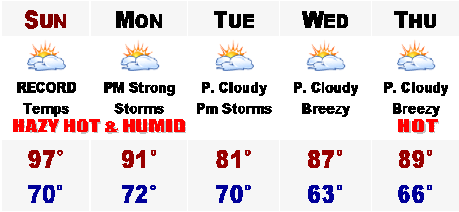
More rainfall is on the way for Southern New England. Heavy rainfall and thunderstorms, some severe, will crop up this afternoon and we are currently under a Flood Watch for 2-5" of rain through tomorrow night.

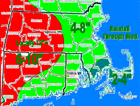
Rain will continue on and off until later next week and these are the final totals expected. More later.

Saturday, June 17, 2006

HEAT INDEX OVER 100 TOMORROW


Happy Father's Day for all the fathers out there tomorrow. It should be an extremely HOT and humid day with highs generally in the mid 90's, except lower 80's on the Cape and upper 70's on Nantucket, where they will get some natural air conditioning from the ocean.

The rest of us will have to rely on electricity to keep us cool as heat indices tomorrow afternoon should be in the upper 90's to lower 100's. The dew points should make it into the upper 60's to around 70, making it feel downright oppressive. Tomorrow, there is the Commissioner's Cup in Wilmington, MA, the second day of tournament play, hoping Woburn beats Wilmington. Also, many of MA youth travel soccer teams are in Amherst, MA for the States. It should be very hot and dangerous to not keep hydrated. Temperatures in the morning should start in the mid 70's by 9AM, mid to upper 80's by NOON, lower 90's by 2PM, and mid to upper 90's by 4-5PM in Wilmington and Amherst tomorrow. Heat indices should hit their peak around 4PM, hitting 100-105. Be safe.

Monday will be another hot and humid day but a cool front from the west will be moving into our area in the afteroon, jeopardizing afternoon summer baseball games with heavy showers and strong to perhaps severe thunderstorms. Until then, temperatures will likely hit 90 again.

Tuesday, cooler and drier weather will be in place, but still expect highs in the lower 80's. The heat returns by later next week as SUMMER VACATION begins for many schools around here Thursday.

Wednesday, June 14, 2006

Heating Up..


After today's thunderstorms that caused localized street flooding throughout the area this afternoon mainly north of the Pike off the South Shore, the heat and humidity will come back in.

Highs in the 90's are likely all the way to the beaches by Father's Day and on Monday of next week, the last half week of school, for many in eastern Massachusetts, highs may be all the way into the middle 90's. Temperatures thereafter, may cool down on Tuesday with the passage of a cool front accompanied with some thunderstorms.

Saturday, June 10, 2006

Tropics Warming Up for an Active Year


Well, you guessed it. Another day and it is raining again. Another rainy Saturday, but this crazy wet pattern will be breaking with a few catches, some good some bad.

The good news is that tomorrow will be totally dry with sunshine developing in the morning and the sky should remain partly cloudy, but there could be more clouds blocking the sun in the afternoon because when the sun bakes the ground, all the low level moisture from our week's worth of rain will evaporte and condense forming clouds, so the afternoon could very well turn out mostly cloudy. Hope not though. Highs should rebound into the lower 70's and on Monday the sun will be prodominent and highs will be back in the middle 70's for all those baseball and softball games and tee times. Should be a great day and Tuesday should be the same. Absolutely perfect.

Then all eyes turn to the TROPICS...

Tropical Depression ONE has developed just SW of Cuba this morning and is forecast to become Tropical Storm Alberto, the first named storm of the season, by late tonight or tomorrow. Right now it looks like anywhere from Tampa to just east of Pensacola on the Gulf Coast of Florida will be the target zone for this Tropical Storm to make landfall, winds at this point could be anywhere from 45-65 mph. Still too early to speculate on this right now. Then things get interesting as it speedily leaves the peninsula of Florida and regains some strength on the northeast coast of Florida. Current projections have this being a minimal tropical storm or just strong low pressure system at this time with lots of tropical rains and strong winds.

Does it hug the coast like a classic Nor'easter? Will it still keep its tropical characteristics? How much rain will it dump? How strong will it be?

These are some tough questions that will need to be answered because even if it is not a tropical storm when and if it arrives in Southern New England later next week, we just cannot hold anymore water in our saturated soil. In the past 40 or so days, Boston's Logan International Airport has received a record 18.43" of rain, likely with another half inch to three quarters of an inch iwth today's rain added on top of that. And parts of the North Shore in the Merrimack Valley have received anywhere between 20-28" of rain in the past month alone. The rivers are full. If this did make it all the way up the coast rainfall totals could easily surpass 4" and local amounts could even exceed 6". It would be a disaster.

Here is the current forecasted track from the National Weather Service. I will have more on this developing situation later on if this possible tropical system becomes an imment threat to Boston and New England.


Wednesday, June 07, 2006

June Nor'easter


Heavy rains are starting to an end across the Bay State this evening after today's early summer Nor'Easter. Rain was excepitonally heavy towards the South Shore today as rainfall totals across this area ranged from mainly 4-7". Farther to the northwest, rainfall amounts gradually tapered to between 1-4". This is after last weekends 2-6" of rain and a mid May's 6-20". Winds today also gusted to near 45 mph at Logan International as well.

Tomorrow will bring a day of early morning showers then just turn cloudy with occasional showers and drizzle to keep it a wet and cool day. Friday more rain will develop. Friday's rain does not look to be as potent or heavy as today's storm. Once we get to the weekend, the sun will come back out and temperatures will slowly warm to near normal levels; mid 70's by early next week. Stay dry.