Monday, December 31, 2007

NYD: FINAL CALL

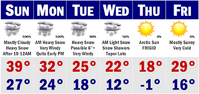
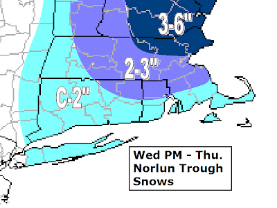
Here is the final call for the 2008 NYD storm. It is basically perting out on all the models this afternoon and it looks like at least portions of SNE will prodominently see a rainstorm out of this one. Places like Boston to near Worcester, Plymouth, Providnce will all see mainly ain out of this one. Sorry, I wish I had better news for you guys. The boundry layer will just be too warm here for anything ore than a few sleet pellets mixed in with the moderate to heavy rainfall, that will be short-lived. Not drawn out like the NAM was showing us yesterday afternoon. There will still be snow with this system. If you travel to the hills of Worcester County and western Mass you will pick up between 2-4" of snowfall. SNH will see about the same as that as well. Here it will be a gloppy snow with temperatures 31-33 degrees. The areas that see rain will be more like 34-35 degrees, which will make all the difference. Upstairs, the temperature will be cold enough to support snow, it will be that last 1000-2000 feet that will turn things over to rain across the coastal plain. Central New England will do the best with this storm, picking up a quick hitting 4-7" of snow, with amounts dropping off as you go north, 1-3". In the end, this will be our last 'winter' storm for a while, as we will be going into an extended warming trend by this weekend, after a brief stint with Arctic air. Thursday, highs will be in the mid and upper teens.

In about a week, temperatures will be soaring into the 40's to perhaps the 50's and after about a 10 day stint of departures of +4 to +8 degrees, we will start to return to a wintertime pattern. BTW, Boston did not break the record. Only picked up 0.8" of snow from this past storm, bringing them to 27.7" for the month of December, just 0.3" shy of setting the new record.

Thats it for 2007, I will see you next year.

New Year's Day Storm First Call

Good morning. We are finishing up one bust of a storm and heading right into the forecasting of the next one. No looking back, right? Well, it will be really really close whether or not Boston gets the record right now, as it just changed to snow in the city about twenty minutes ago, but with temperatures around 34 degrees. It will be close. Most areas have picked up between 2-3" in Worcester County, and may pick up another one to perhaps two inches before it quickly ends before 8AM from SW to NE. That is where a spot 4" or 5" amount is possible. Closer to the city's suburbs, 1-2" is more likely. The city may come just shy of getting that 1.1" for the record. Down on the South Shore and Cape, sorry, you guys got all rain and will finish the storm with all rain and I can't say it looks much better for the next storm. Now after this all wraps up later this morning, the sun will break out of the clouds later today and this will shoot up temperatures to between 38-45 degrees this afternoon, so there will be melting and this is another reason why I am not optimistic of tomorrow's event being all that white in Boston proper.

For tomorrow, I think that from Boston points S&E, there will be mostly rain out of this next one. There could be a slushy inch of snow for places close to Boston, say up to Brockton and Milton, however, that would be about it. Once you get past Boston and especially past Route 128, an accumulation of 1-4" is possible. More if there is less mixing with rain, less if there is. You have to get out towards the Worcester Hills and western MA, southern NH to get into any significant snow. I am pretty confident that a good 5-9" of snowfall is possible here. NW of here, that is where the bonanza with this next storm will likely be. Snowfall amounts of 7-14" are possible, but if one model is right, we would have to cut QPF in half and in turn cut all these snowfall accumulations in half, so that is why I am not at all confident of this approaching storm system, coupled with the fact that I just busted BIG TIME with today's storm. Sorry about that. Did not expect to wake up to rain pounding my window 2-3AM.

I will have more on this forecast later and show if there is any warnings or advisories issued by the NWS later today.

Saturday, December 29, 2007

Heavy Snow by Tomorrow Night

We have got ourselves busy the next several days with two storms that are going to affect New England. The first one is the one for tomorrow night and early Monday morning that will dump good snowfall for all of New England, a widespread 4-7" of snowfall, with a sweet spot along the Mass Pike from Springfield, to Worcester, to Boston and up towards the North Shore, encompassing Lowell and Portsmouth, NH. Here is where I think there will be local amounts of close to 8-9" of snowfall. This is not going to be real power from say Route 2 southward. It will be much more of the wetter type of spring snows wit the snow falling when temperatures are in the 30-33 degree range. That is what will prevent anyone from seeing over 10 inches of snowfall, coupled with the fact that this baby will be moving. Even the Cape will do fairly well with this storm system. I can see some mixing with rain down there, but I think it will be mainly a wet snow that falls there with 3-6" for southern RI and the Cape and Islands. I would say that Nantucket will see 1-3", but they are always a wild card and come closer to 6" or see a coating and switch to rain. Further north to the South Shore, including Hartford, Providence, to Quincy, a good 4-7" of snowfall will fall during the storm. Again, it will be a wet snow for the area here. Then you get into the pink sweet spot with close to 6"+ for many towns in here. It is still to be determined where this band of heavy snow growth sets up, but looking at the trends on the GFS and other computer models, it looks like this will be the area with the maximum snowfall. As I said 7-9" is possible in this spot. As you get farther removed from the storm, snowfall amounts will decrease, but snowfall amounts of up to 4-7" are still going to be common for much of CNE and NNE will still see a couple to several inches out of this storm as well.

Here is my city by city snowfall forecast....
Boston, MA 7"
Worcester, MA 7"
Springfield, MA 6"
Quincy, MA 5"
Providence, RI 5"
Hyannis, MA 4"
Plymouth, MA 5"
Hartford, CT 6"
Nashua, NH 6"
Gloucester, MA 8"
Keene, NH 7"
NEXT STORM DISCUSSION: We have to talk about the next storm now. I know that you probably don't want to here it, but once our first storm ends sometime around 11AM - 2PM on Monday, our next storm will be right on its heels and could be even larger than its predecessor. We will have about a 12-18 hour lull in the precipitation before the second storm's snow starts to move in from the S&W. At first, it looks like a measely clipper that would be moving right through our area dumping maybe 2-4" of snowfall in a short amount of time. However, on the past runs, the storm looks a tad more potent and now is starting to get a reflection of a secondary storm forming off the Mid Atlantic coast, which would mean oodles of more snow for all of New England. This has been showing on the models for the past two runs, more so on the 18z runs of the models and it looks like this thing has the potential to drop another 6"+ over our area on New Year's Day. Timing of this storm is still somewhat unknown, but I would say that if you are out until 5-7AM in the morning New Year's, Tuesday, you run yourself the risk of getting snowed in wherever you find yourself. This storm could have snowfall rates higher than its predecessor's 1-2"/hr, for it will be a dry fluffy snow falling into air that is in the 20's. We could potentially see snowfall rates in the extreme category of 2-4"/hr. I know its still some 66-84 hours away, but it is becoming more and more ominous with each run of the models. We will take it one storm at a time, but the potential is there for a biggie.
Interesting fact is that much of SNE has about 5-10" of snow already on the ground, so theoretically, many towns could have over 15-30" of snow ON THE GROUND by Wednesday! Wouldn't that be amazing. That is what will keep us very cold with the Arctic airmass coming down behind the clipper. We could be talking a subzero morning here Thursday with windy blowing snow and highs only in the upper 10's. We will moderate to around 40 by the end of next weekend, but the damage will have already been done.
Stay tuned to more forecasts and NOAA. I almost forgot to mention that all of SNE, except the South Shore and Cape are under Winter Storm Watches. I will post updates tomorrow of any warnings or adviories that go up for this first storm of this one-two punch!

Friday, December 28, 2007

First Guess on Dec 30-31 Nor'easter; Final Tomorrow PM

Here it is. My first guess for the upcoming Nor'easter that will help Boston smash its December snowfall record from 37 years. Talk about last minute. All the newest data came in around 6PM tonight and confirmed my thoughts that this will be a mainly snow event for much of southern New England, except the immediate South Coast of CT, RI and of course the Cape and Islands, where some mixing is always possible. I know it is a little early in time for putting out a map for this system, but I had to do it to give some reference point for what this storm could potentially do come Sunday night and into Monday morning. I don't think that this will be a blockbuster by any means, reason being is that the speed of this storm system will be like a rocket. It will shoot up the entire east coast in less than 24 hours. I don't think anyone will see more than 8-12 hours of accumulating snow from this storm system. However, the 8-12 hours that it does snow, it will be falling at the rates of 1-2"/hr. So, if you do the math, 6-12" for much of SNE looks like a good bet with this storm system. If it were to slow a bit as the EURO and UKMET are advertising, and we were to get extended accumulating snow than what the GFS is currently showing, some places will see some hefty snowfall totals from this one. A slower storm would give more time for the storm to gain some strength as well and that would means stronger winds and coupled with the fact that most of this storm will be in the 29-33 degree range, very marginal, the wet snow could cause power outages alone, but with wind, all bets are off. It could be a cold Monday morning in many peoples homes. So, as you can see there are still many many variables to be worked out for this storm system. I don't think areas from Boston points south and east are totally out of the woods regarding precipitation types, but I am pretty confident everyone away from the Canal will stay all snow with this event.

Next things we want to peg down with this storm will be...

1) Timing...when is this going to start. Right now it looks like Sunday night around midnight.

2) Duration....As I said before, looks like an 8-12 hour bout of heavy accumulating snows, longer duration would make all the difference.

3) QPF...how much 'water' is going to fall from the sky.

4) Snow Ratios...right now I would say right around a 10:1 ratio, which is not a fluffy snow, but not glopping wet which would be 5:1 ratio.

5) Winds...strong winds coupled with heavy wet snow would result in power outages and some minor splashover.

6) Exact Track of LP...will as always make all the difference on who sees what type of precipitation. Looking right now like an all snow event away from South Coast and Cape.

7) Speed of LP...will determine the starting time and duration.

8) Monitor your Thermometer at Home...a temperature of 31 will make a world of difference compared to temperatures around 33-34 degrees for accumulations.

I will be back on tomorrow for any watches that will likely be issued by the NWS. Go out and buy some bread and milk. Oh yeah, don't forget to stock on the nachos for the big game tomorrow thats on every channel. Lay off the beandip though...just kidding. Anyway, bring an umbrella out with you tonight if your going to be out on the town past midnight. Rain is moving in.

Stormy Times Continue

Stormy weather dominates the headlines for much of the country as we head toward the new year of 2008. As we speak there is a good sized snowstorm dumping over a half foot of snow over Chicago and other parts of the Midwest. That storm will get here after midnight and be a warmer with maybe a brief burst of snow in southern NH that will even quickly change to plain rain there as temperatures warm into the mid and upper 30's. We will see the rain come down pretty heavy for a while with it all winding down sometime early on Saturday morning, before the sun starts to come back out in the afternoon. It won't be a flash freeze situation, temperatures will actually be quite mild, in the lower and middle 40's. It actually looks nice tomorrow afternoon. Then all eyes need to be put down to the Gulf States, namely New Orleans as we watch where our next storm will be coming from.

SUNDAY NIGHT/MONDAY MORNING STORM DISCUSSION: This storm has been on the models forever it seems, and all over the maps. Earlier this week, the GFS had this storm going weakly out to sea in a flat progressive pattern. Today, the GFS is right about ready to go gangbusters for much of the I-95 corridor from DC to Portland, ME. Everywhere from NYC northward to Boston on the latest 12z GFS run would be getting a fairly decent dump of snow on the order of 6"+. Mixing issues will always have to be watched down on the Cape. Sorry guys. But there is another reliable model, not very reliable lately, that takes the storm out to sea, but in the past several runs, it looks to be siding with the more amplified GFS, EURO, and UKMET, and JMA for that matter. That is pretty good agreement in my book.

My concerns with this storm system is that there is no blocking high pressure over SE Canada to stop this NW trend on the models. I see no reason why this won't keep going west, northwest on the next runs, by say 50 miles or more. There is nothing there to stop it. I don't think it will become on Appalachians runner, but if it wants to hug the coast more, then we will have precip type problems in southern New England, especially along the coast. However, with the models the way they are looking right now and the fact that we are heading inside 60 hours for this impending storm, I believe that much of SNE has a good shot at seeing some significant snows Sunday night and ending Monday early afternoon. I will be watching this like a hawk, I can tell you that.

Tonight's 00z and tomorrow's 12z runs will be HUGE as they will pretty much nail the final track of the storm system. Right now I like where we are sitting and am becoming increasingly confident that somewhere in SNE will see a fairly good dump (6"+) from this Nor'easter. I am almost certain that Boston will get that 1.1" to break the all-time snowiest December record of 1970 as well. Not etched in stone just yet, but I'm pretty confident. Maps will start to be posted later today, if not, tomorrow.

One thing is for sure. The skiing this weekend in the north country will be excellent with many resorts reporting the best ski conditions in many many years. Many areas up north picked up between 4-6" of snow yesterday and as we here in SNE get rained on tonight, they will be picking up some more powder. Many ski resorts in northern NH and ME will pick up between 4-8" of snow tonight from this storm system. Northern New England could do well with the storm come Sunday night as well, so you can imagine that the skiing will be excellent.

More on the storm tonight/tomorrow.

Thursday, December 27, 2007

Another 'Wet' Storm Saturday

Today's snow threat seems to be whaning ATTM. The shield over western NY State looks to be too far north and heading in a NNE direction to give SNE any meaningful snows this afternoon. I still like my forecast from yesterday, I would just move all the snow boundries up north by say 50 miles. Boston will probably not break the record today. The last chance would be on Monday, New Year's Eve and there is an ocean storm threat, but at this point, it looks like it will stay mostly out to see. Our next storm comes tomorrow night into early Saturday morning, as a rainstorm. It may begin as a brief period of some mixed rain/sleet/snow far N&W of Boston and Worcester, but even there it should change to all rain. The snow will be confined to extreme northern Vermont and New Hampshire. Maine looks to do pretty good with this storm, especially from Bangor, points north. In these areas, Saturday's storm good potentially dump 6-12" of snowfall. That will freshen up the bases as today many ski areas in central VT, NH, and ME will see a general 3-6" snowfall with the LP in NY sweeping towards the coastline. Sunday brings slightly colder air, upper 30's, which is seasonable for the date, before we have that potential miss on Monday.

Right now I would say that there will be a few snow showers in the air for First Night, but I can claim to much more than that. Temperatures around midnight Tuesday will be very cold. Boston will likely see temperatures dipping into the middle 20's as areas outside of the city will quickly be falling through the upper 10's. This will yield a frigid and windy back to school Wednesday with temperatures in the morning in the single digits, while afternoon temperatures only struggle to hit 20 degrees. Thereafter, we will have a 3-4 day period of cold weather before the entire country east of the Rockies will start to warm up. We could see next week with highs in the 20's mainly, but going into the weekend and especially the next week, we could be seeing high temperatures pushing 55-60 degrees. The January Thaw. Its a long way out, so it will need to be watched.

Thats all for today.

Wednesday, December 26, 2007

One - Two Punch Thursday

We have got ourselves a wintery day on the way for tomorrow. A coastal low has developed off the tidewaters of North Carolina this morning and is gathering steam and heading NNE. High cloudiness is already streaming into SNE this afternoon from this storm system. It will still be a graze for SNE, but we really do not need to worry about this first part of wintery weather in SNE. Tomorrow morning will feature mainly rain from Route 495, points S&E. Boston will see mainly light to perhaps moderate rain tomorrow morning as the LP passes just south of Nantucket. This will result in heavier rain down in SE Mass and the South Coasts of RI and CT. Rainfall amounts up to one-half to one inch are possible in these areas. NW of Rt. 495 may feature some very light freezing rain or sleet as temperatures by tomorrow morning in these areas will be very borderline, with temperatures probably in the 30-32 degree range. Closer to Boston, temperatures will likely be more in the 33-34 degree range, keeping them rain...for the morning. Temperatures aloft should cool towards late morning and early afternoon ahead of the development of a 'Norlun' signature developing off of the morning coastal. This will develop a finger of snow from the LP dying over Upstate NY and the coastal moving away from the SE coast of Massachusetts. This will give much of SNE and up to NNE a good 6-8 hour period of light to moderate snow with a band of heavy snow probably developing somewhere from Portsmouth, NH to Conway, NH to Portland, ME

This is outlined in my map for snowfall in Part 2 of tomorrow's wintery weather. Where that band of heavy snow develops as always with 'Norlun' type setups, that is where the heaviest snowfall accumulations will be. Last week it setup from Portsmouth, NH to Boston, MA. Much of NE Mass and NH picked up 6-10" of snowfall, after having morning news outlets forecasting 1-2" Boston the morning of the event. So this will be a very changeable forecast. Right now, I think that is where the heavy snowfall will take place, but there will be a wide swath of light to moderate snowfall with this one for much of New England, unlike last week with some places seeing close to a foot and others some twenty miles away seeing coating. There will be a wide swath of 2-4", with locally 5" of snowfall with this one from north of the Mass Pike all the way into central VT and northern NH and central ME. Boston will be on the line, so a couple inches is possible in the city itself, which would be enough to break the December snowfall record of some 37 years. Down on the South Coast to the Cape, it will be cold enough for snow, but I think you will be removed from the heaviest of the precipitation, so you will see generally under one inch of snowfall. Extreme northern New England will be removed from the heaviest of precipitation as well so 1-2" for much of northern ME to under one inch along the Canadian border.

This is a very changeable forecast that will likely turn into a 'nowcast' type of event. Right now, I like my maps for this event up above, so expect a wintery ride home tomorrow because most of this snow will be falling in the 3PM - 8PM timeframe, just perfectly placed to ruin your drive home. I will have updates all day today and tomorrow with any advisories that get posted from the NWS. I could see some warnings being posted in SW Maine, but that is yet to be determined. Check in later.

Tuesday, December 25, 2007

Boston Poised to Break December Snowfall Record?

It has felt like springtime around these parts the past few days. Highs in the 40's and melting snow. Today was a beautiful day and it classified as a white Christmas even if it was some of the warmest weather we have seen in some time, since Thanksgiving. We have some more mild weather ahead, but we also have snow back in the forecast as well. First, lets talk about tomorrow. Tomorrow will be a day that starts off bright and nice, but cold, which will likely have some black ice on the roadways until say 10AM. So be aware of this. All black ice will quickly melt by noontime as temperatures will be surpassing 40 degrees on their way to highs in the mid to perhaps upper 40's. There will be a light breeze that will make the day feel all the more refreshing. Down on the South Shore and Cape you will notice some dark high clouds start to develop from the ocean as an ocean storm will ever so closely come right up against us without getting us into the action.

POSSIBLE THURSDAY STORM DISCUSSION: That said, there will be a period of light to moderate rain on the South Shore and Cape, with perhaps a rain/snow mix all the way up to Boston, Worcester, and possibly up to say Lowell. This would not accumulate, but we will turn our eyes out towards western New York State at this time to see a band of snow with a seperate system advancing towards New England. Both of these storms will start to 'link' up right over southern and central New England, which will cause snow to develop for much of New England at this time, with perhaps a mixture of rain and snow down on the South Shore and Cape Cod. North of the Pike, Thursday evening and night, perhaps right around the evening rush, the snow will pick up in intensity and start to accumulate. Right now it looks like south-central Vermont and New Hampshire through Maine look to do the best with this storm system, but those accumulating snows could very well make it down to Boston. As you probably know, Boston only needs 1.1" to break the old record set in 1970 for December snowfall, the record being 27.9". Boston currently sits at 26.9", just one inch off the record books. I am not sold on accumulating snow just yet as the usual case is that one model shows nothing while the other gives us a bit of accumulating snow on the tune of a couple inches. Such differences, only 24-48 hours out! So, I will hold off on making any maps just yet. I may make one tomorrow morning/afternoon, as more data comes in. It will be interesting to see how this pans out.

VERY PRELIMINARY CALL: If I had to make a guess at this time. I would say maybe a coating from northern CT/RI along the Mass border. Nothing South Coast and Cape. Along the Pike into Boston up to Route 2, I would go with a light, but sloppy, 1-2" of snow. North of Route 2 into southern-central VT and NH through southern ME, 2-5" of snow is possible. These numbers will most certainly have to be fine tuned tomorrow, and especially tomorrow night as the final data comes in.

This storm will have lots of surprises, so expect the forecast to change. Thereafter, a warm rainstorm is slated for Saturday before we cool off again going into the New Year.

Monday, December 24, 2007

The December Thaw

We are in the middle of our December Thaw right now. Snowpack across SNE has taken a big blow the past couple of days. Two days ago, much of SNE had a healthy 10-20"+ snowpack, today much of SNE is generally under 10". We are only going to continue to lose our early impressive snowpack. More mild times are ahead for SNE. This afternoon will make it into the mid and upper 40's. Tomorrow will be much of the same with mostly sunny skies and highs in the middle 40's. Lows will struggle to get below freezing tomorrow night so there will be extended melting going on and this will propell us into a warm Wednesday, return day Wednesday with highs getting back to around 50 degrees. I have been watching a storm system for the past couple of days for Thursday and it looks like it could now get close enough to our area o see some rain on the southeast coast of Massachusetts and Rhode Island.

Thereafter, it looks like we could cool and we could see some light snow sometime later next weekend. That is way far out I won't even go into it. More tomorrow and enjoy your Christmas Eve.

Saturday, December 22, 2007

Heavy Rains Raise Flooding Worries Sunday

Sorry I haven't posted in a while. Thursday's storm system was quite the snow producer for eastern New England. Many areas in eastern MA and NH and ME saw between 6-10" of snowfall. Boston picked up over seven inches of snowfall, putting their December snowfall stats up to 26.9" for the month. Now with snowpacks of 10-20" across southern New England, tomorrow raises my worries for street and basement flooding. The roads have shrunk, clogging many drains with ice and snow. This will be bad with rapid snow melt tomorrow and heavy rains, on the order of one-half to one inch of rainfall. This will add to the 2-3" of liquid equivalency in our snowpack right now for a grand total of 4", on our roofs. It could be a bad day tomorrow for collapsing roofs. Thereafter, we will cool down, but not to the levels where we have been the entire month. Maybe upper 30's to around 40. Nothing too cold. Next storm threat comes Thursday, but that looks to be mostly out to sea. It will be watched nonetheless. Enjoy your last minute shopping today.

Tuesday, December 18, 2007

More Snow

We have got ourselves another snowfall on the way for eastern New England. A clipper is coming out of the Great Lakes tonight and tomorrow and once it hits the Atlantic it is going to explode and throw an inverted "Norlun" type trough into eastern New England. These events are very finicky and change during the actual event. That said, it looks like much of SNE will at least see some snow. The further SE and SW you live, you may see it start as rain and stay as a wet snow for the event with temperatures hovering around 32, but everyone else should cool enough to see mostly snow out of this event. Many people will have to break out the shovels for this one again and people in northeastern Mass and up onto the Seacoast of NH, you may need the plows out again. There we could see 3-6" of snowfall. There will be a spot somewhere between extreme SW coastal Maine through the Seacoast of NH and northeastern Mass that could see over six inches of snowfall. Where this band of heavy snowfall sets up will make all the difference. Either way, I think much of eastern Mass could see a general 2-3" overall. This will mainly occur late tomorrow night and into the day Thursday. Thursday could be a day that features on and off snow showers or 'snizzle' throughout the day, giving the wintery look. A few delays will be possible in Middlesex and Essex counties.

I want to stress that this is an ever evolving storm system and it will need to be watched through tonight through tomorrow and through the actual event to see where exactly this heavy band of snow decides to set up. Someone in eastern New England will wind up with up to 8" from this...where that is, is too hard to pin point at this time. Stay tuned.

Sunday, December 16, 2007

Finally a Reprieve!

Last week was one of those rare jam packed weeks with every night something new was happening, whether it be rain/ice/snow. Thursday many areas across SNE picked up between 8-12" of snowfall. Today many areas picked up 7-11" of snowfall, making a four day total of 15-23" of snowfall. The snowbanks are pretty much unreal right now where I live. Boston has seen 19" of snow so far, couple with the 1.3" it saw on December 2-3, Boston is now over 20" of snow for the month of December. It kind of snuck up on us. I am already over 24" for the season so far! And winter hasn't even started. This week looks to be much quieter than last week, but cold nonetheless. The snow will not be going anywhere soon. I've got an 18" snowpack right now with a glaze of ice. Its amazing out there. Tomorrow will be a cold and windy day with wind chills in the teens all day. We try to warm up this week, but we will likely not budge 32 degrees until next weekend, with a storm JUST missing us to the south on Friday. That will need to be watched. It doesn't look like a major deal at this point in time right now. Maybe some snow for the Philadelphia and New York City areas. I think we can share. I think we will get that white Christmas, but lets not bank on it just yet!

Major Snowstorm Comes to an End

SNOWFALL TOTALS

MASSACHUSETTS

...SUFFOLK COUNTY...

Boston 8.8 1200PM 12/16 (Logan Airport)

...BARNSTABLE COUNTY...

WEST FALMOUTH 4.9 830 AM 12/16
SANDWICH 4.6 801 AM 12/16
BOURNE 4.3 852 AM 12/16
CENTERVILLE 3.5 648 AM 12/16
HYANNIS 2.5 646 AM 12/16
SAGAMORE 2.0 649 AM 12/16

...BRISTOL COUNTY...

MANSFIELD 7.0 1251 PM 12/16
ATTLEBORO 6.5 114 PM 12/16
TAUNTON 6.1 1250 PM 12/16 NWS OFFICE
NORTON 6.0 859 AM 12/16 CO-OP
REHOBOTH 5.4 1040 AM 12/16
FALL RIVER 5.0 854 AM 12/16
NORTH ATTLEBORO 5.0 1236 PM 12/16
TAUNTON COMMON 5.0 808 AM 12/16
ACUSHNET 4.0 651 AM 12/16
NEW BEDFORD 3.6 750 AM 12/16

...DUKES COUNTY...

VINEYARD HAVEN 2.0 651 AM 12/16

...ESSEX COUNTY...

SALEM 10.5 238 PM 12/16
BEVERLY 10.0 1233 PM 12/16
GLOUCESTER 10.0 101 PM 12/16
METHUEN 9.5 1025 AM 12/16
MARBLEHEAD 9.0 932 AM 12/16
SOUTH LAWRENCE 9.0 303 PM 12/16
TOPSFIELD 9.0 1040 AM 12/16
DOWNTOWN LAWRENCE 8.5 1112 AM 12/16
LAWRENCE 8.5 1112 AM 12/16
WENHAM 8.5 1040 AM 12/16
WEST PEABODY 8.0 1112 AM 12/16
GEORGETOWN 7.5 1114 AM 12/16
PEABODY 7.5 1109 AM 12/16
IPSWICH 7.1 249 PM 12/16
NEWBURYPORT 7.0 905 AM 12/16
HAVERHILL 6.5 1001 AM 12/16

...FRANKLIN COUNTY...

NORTHFIELD 9.5 1024 AM 12/16
EAST CHARLEMONT 8.5 313 PM 12/16
LEVERETT 7.9 325 PM 12/16
CHARLEMONT 7.5 843 AM 12/16
GREENFIELD 7.0 750 AM 12/16
EAST WHATELY 6.0 229 PM 12/16
SUNDERLAND 6.0 933 AM 12/16
SHELBURNE 5.0 854 AM 12/16

...MIDDLESEX COUNTY...

DRACUT 11.0 1200 PM 12/16
LOWELL 10.3 225 PM 12/16
LITTLETON 10.0 1004 AM 12/16
EAST PEPPERELL 9.7 239 PM 12/16
PEPPERELL 9.7 239 PM 12/16
WAKEFIELD 9.5 152 PM 12/16
ARLINGTON HEIGHTS 9.0 1235 PM 12/16
HUDSON 9.0 1115 AM 12/16
READING 8.8 1116 AM 12/16
WOBURN 8.5 1147 AM 12/16
TOWNSEND 8.5 1244 PM 12/16
DUNSTABLE 8.4 100 PM 12/16
CAMBRIDGE 8.0 927 AM 12/16
FRAMINGHAM 8.0 1255 PM 12/16
NATICK 7.5 1255 PM 12/16
SHIRLEY 7.5 1016 AM 12/16
WINCHESTER 7.5 127 PM 12/16
ARLINGTON 7.0 928 AM 12/16
AYER 7.0 940 AM 12/16

Thats it...we may see a few snow shower tonight, but other than that, the storm is over and clear the snow in eastern Massachusetts before the flash freeze tonight. You have a few more hours. Back to regular forecasting tomorrow with the extended forecast. This was a wild week!

Saturday, December 15, 2007

Winter Storm Warnings and Advisories for Much of New England

I will be the first to tell you that this storm is killing me. I don't know what to expect. This setup should send us a mostly rainstorm, but that is not what the models are showing. In fact, temperatures just outside of Boston may never get up over 32 degrees. This Arctic air that moved in early this morning means business. My high today was 21 degrees. Right now, I'm sitting at 16. This cold air is really going to help us in regards to snow. Once the precipitation starts, evaporational cooling will take effect and everyone will start as an initial burst of heavy snow. By 3AM the snow should start here in eastern New England and by 5-7AM the snow will be falling heavily. Snowfall rates early Sunday will be on the order of 1-2"/hr. This will allow the Cape and Islands to maybe see that 1-2" on the first hour of snow. Winter weather advisories are up for the entire state south of the Pike, including Boston and the coastline for a general 2-5" near Boston to 1-3" south. North of the Pike, a winter storm warning is in effect for a general 4-8". The mountains will do well with over a foot.

I pushed the snow lines further SE from my earlier thinking. It will now be going into nowcasting mode and watching observations. It will be a tough forecast. Lets get through this one and then next week will be much more quiet. Beware of the flash freeze tomorrow night. Whatever slush is on your driveway tomorrow night will be there for quite a while.

Updates tomorrow with observations and radars. Its going to be a wild ride. Oh yeah, winds up to 60mph tomorrow afternoon with heavy wet snow could lead to power outages north of the Pike. Keep that in mind. Have your generator on standby for the 1PM kickoff of the Pats and Jets.

Tough Forecast; Making Final Call

This storm does not look as good as say it did last night. We have been banking on a front end dump from this storm and I just don't think we are going to do it. I believe the Cape starts off as mostly rain with a few sleet pellets mixed in. Then it will change to all rain even up to say Hull and Quincy before the storm even gets started. Boston may get an hour or two of snow, but quickly change to sleet and rain within hours of starting. Snow accumulations in Boston look to be around an inch. The pink area has a chance of seeing anywhere between 1-3" snow followed by a period of sleet and freezing rain. I don't think freezing rain will be a big deal from this storm. Sleet will be the primary form of ice here with this storm. I pushed back the 3-6" swath much further west. Here, a change to sleet is even possible for a duration of the storm, cutting down on amounts. Once you get way out past Rutland, VT, will see over 6" of snow with perhaps over a foot in northern New England.

I will do my city by city forecast for this storm....

Providence..........Less than 1"
Hartford...............Around 1"
Worcester.............2-3"
Boston...................Around 1"
Nashua, NH..........3-4"
Keene, NH............4-5"

I will post any advisories or warnings that should go up today by the NWS.

Friday, December 14, 2007

First Guess on Nor'easter

Here is my best guess for the weekend storm today. I do believe that all of SNE will experience some snowfall this weekend. Even down on the Cape and Islands. Everyone will start this storm as a quick burst of heavy snow. It will put down a quick 1-3" before the changeover for everyone, more NW. Then the Cape and South Coast will start to change over to all rain and sleet further NW towards Quincy and coastal locations. Temperatures will likely come up to the low 40's on the SE portion of Massachusetts early Sunday morning before the big flash freeze. Further NW including Worcester, Hartford, and Boston's immediate NW suburbs, there will be a longer period of snow, followed by more sleet and then plain rain even here. All said and done a quick 3-6" of snowfall will accumulate. As you continue to head NW, the snow will quickly increase to 6-12" in southern NH and northern Worcester County. Here a mix with if not total change to sleet/rain is possible too. You will have to head into Upstate NY, VT, northern NH and ME to see all snow. Here the possiblilty exists for a healthy 12-20" of snowfall. This storm reminds me of the Valentine's Day snowstorm of last year. It will be a similar setup. Boston got about 2" from that one, but nearby suburbs quickly picked up 6" of snowfall. We will have to wait until tomorrow to see how strong the cold is associated with the Arctic front.

Warning...if this storm tracks a little farter SE, push that 6-12" into Boston. It it travels a little farther NW, then we will see mainly rain here in eastern New England. Right now, I like the track where it is. The GFS has been extremely consistent in this track for a couple days now and I feel this is the best forecast right now.

Update tonight or tomorrow if any watches or warnings are to be posted by the NWS.

Wednesday, December 12, 2007

Quick Hitting Winter Storm on the Way

6PM UPDATE: The new models have come in and it looks like this storm for tomorrow is going to be a tad slower in leaving and a bit 'wetter' in regards to QPF amounts. I have really upgraded snowfall amounts for tomorrow. GFS and NAM have pretty much gone gangbusters with this storm for tomorrow and NAM actually paints up to 16" of snow for Providence tomorrow, while Boston gets between 10-12". GFS has a wide strip of about 12" of snow across SNE. Even the Cape now looks to be all snow with this event. Hyannis has just as much if not more of a chance of seeing a foot of snow from tomorrow night's storm as Boston. Heavy snow warnings are up south of the Pike right now with winter storm watches in effect north of the Pike into southern New Hampshire. Heavy snow warnings will be soon issued for north of the Pike and it is going to be a doozy tomorrow. Widespread delays and cancellations on Friday.

Timeline....Snow starts from west to east from noon to 3PM. It will end sometime before midnight now. It will be an amazing storm with the peak of the storm during the evening commute with snowfall rates of about 2-4"/hr. That strip near Hartford/Providence/Plymouth to Brockton to get that 12"+.

It's going to be a mess. Stay tuned for later forecasts.


1PM UPDATE: Our first major winter storm of the 2007-2008 season is upon us here in SNE. We have a quick hitting winter storm on the way for tomorrow. You wouldn't know that a big snowstorm was on its way to SNE if you stepped outside today. Temperatures are all the way into the mid 50's down on the southeastern part of the state. Even I am flirting with around 50 degrees this afternoon, whith much of the snowcover vanished with a gusty wind. However, a cold front is in the wings and will drop temperatures into the upper teens and low 20's come morning to set the stage for our first significant snowstorm of the season. This storm will just be an appetizer for what could become a blockbuster of a storm Sunday. I'll tell you, this is what I live for! The models have been going back and forth regarding tomorrow's storm system, but one model hung tough the entire time and never wavered. For weather enthusiasts like myself, we should all give the GFS a round of applause. NAM crapped the bed, but now it is on board with the big storm for tomorrow.

So first of all, winter storm watches and heavy snow warnings are already in effect down in CT and RI...I would expect watches/warnings to make it up to all of Massachusetts and southern NH, except the seacoast of NH, as they will probably get an advisory from their NWS. The rest of SNE will likely get a heavy snow warning/winter storm warning from Taunton NWS.

The timing of this storm is very compact. We will likely see snow break out sometime after dark tomorrow night, say around 7-10PM. It will quickly become heavy. In fact, we will only have a SIX TO EIGHT HOUR period of accumulating snow. You can imagine with the snowfall totals I am forecasting...snowfall rates could approach 1-3"/hr. Visibilities will come under 1/4 mile overnight Thursday, so be careful if you have to be out late. Snow will wrap up before say 5-7AM on Friday morning and I believe most school districts, especially south of Route 2 will be closed. Delays north of there. So enjoy the warmth now and we will take it one storm at a time. As you are shoveling and snowblowing Friday, I will talk about the storm that will probably bring more heavy snow into all of New England come Saturday afternoon and night. Better yet, just wait until Sunday night to shovel.

We've got a busy few days ahead. Enjoy!

SNOWFALL TOTALS FOR SELECTED CITIES...

Boston, MA 6.5"
Lexington, MA 6"
Worcester, MA 7"
Methuen, MA 4"
Plymouth, MA 8"
Foxboro, MA 10"
Hyannis, MA 6"
Springfield, MA 7"
Salisbury, MA 4"

Providence, RI 9"
Warwick, RI 8"
Newport, RI 5.5"
Coventry, RI 10"

Hartford, CT 7"
Tolland, CT 8"
Bridgeport, CT 5"

Nashua, NH 5"
Manchester, NH 3"

Tuesday, December 11, 2007

TWO Storms Watching...Thu PM and Weekend; Updates Soon

I am sure everyone has been hearing about the possible storm here on Thursday, only leading up to the bigger potential 'blockbuster' event here later this weekend. This could be a doozy. I am hesistent in putting out any maps for the Thursday night storm because there is such a large discrepancy in the models at this point. One model gives all of SNE several inches of fluffy snow, while the other barely brings flurries to Providence.

I will put out a call for the Thursday event tomorrow, sorry for being really close to the event, but there is too much room for error right now to make a prediction. It could go either way at this point.

Any maps/discussion of the potential weekend storm will have to wait until this first storm is safely behind us on Friday. A nice warmup.

Saturday, December 08, 2007

FINAL CALL...Dec 9-10 Snowstorm

9PM UPDATE: I am making my final snowfall forecast for the storm system coming through tomorrow night and early Monday morning. This will be no means be a blockbuster or even major storm, but it will be a good storm to mess up tomorrow night's plans and morning commutes on Monday. I have generally made the 2-4" range a bit bigger, encompassing much of SNE north of the Pike. Further north of here into southern NH, is where I would expect the jackpot with this storm. Here I can envision 4-6" of snow coming down before we even talk about a mixture with sleet before it ends very early Monday morning. Boston will get an inch or two before a mix with sleet and freezing rain, but areas in the pink, especially away from the southern coast of the South Shore will stay below freezing through the storm. Its just the fact that the upper levels where the snowflakes form will warm just enough for a change from snow to sleet midway through. The Cape will be above freezing through most of the storm.

Winter Storm Watches have been posted for interior SNE, south of I-90 this afternoon for ice accretions of 0.3" to 0.5"+, which would cause havoc on the power lines and trees. Widespread power outages would be possible. This may either go to a warning (winter or ice storm) or advisory tomorrow and north of the Pike will see a winter weather advisory go up, if not a Winter Storm Warning in southern New Hampshire. I will have more on this forecast tomorrow.

Snowfall/Ice for a few selected cities....

Providence, RI....2" (to sleet/ice)
Harford, CT....1" (to freezing rain)
Boston, MA....2" (to sleet/rain)
Worcester, MA....2.5" (to sleet)
Fitchburg, MA....4" (some sleet mixes in at end)
Burlington, MA....3.5" (sleet mixes in around conclusion)
Lowell, MA....5"
Nashua, NH....5"
Keene, NH....5"
Springfield, MA....2" (to sleet/freezing rain)
Cape Cod....Mainly rain

Thats all for tonight. More tomorrow.

Wintery Mix: December 9-10

Here is my first and probably final call for the storm system moving in tomorrow afternoon and evening. The precip will move in from west to east and will probably start as snow for everyone, but quickly transition to rain/mix on the Cape and South Coast. Further north of there, in the pink shaded region, there will be more of a mixture of snow/sleet, but freezing rain will be the big player here with over a 1/4" ice accretion possible. I would not at all be surprised to see Winter Storm Watches hoisted for this region later on for the ice. More likely Winter Weather Advisories by tomorrow morning, though, for a majority of SNE. In the pink region, there is the chance of about 1" of snow before the flip to freezing rain. Here, by the Monday morning AM commute, temperatures may come up above 32, but that may be pushing it as many mets believe that the GFS and NAM are overplaying the warm air and that the cold will be much more stubborn to let go. In the blue region, we will see more snow from this before we think about a changeover. A solid 1-3" of snowfall is possible, maybe more if this area can stay mainly a snow event. Where it does stay mainly snow, mainly north of the Pike and away from Rt. 128 and the coast, 2-4" is likely with some spots in northern Worcester County maybe getting closer to 5-6", tops.

There is a wide model discrepancy between the NAM and GFS this afternoon, however. GFS paints lots of snow, north of the Pike and a good amount south, but the NAM doesn't give anyone in SNE more than an inch or two, so you can see this is a high stakes, low confidence forecast. A forecast that will likely change. I played it in the middle. Either way, the Monday AM commute is going to be messy with more delays and cancellations likely again.

More on this forecast tomorrow with any advisories, watches, or warnings underway.

Friday, December 07, 2007

Unsettled Wintery Weather Week Ahead

We have had a very wintery week this week. We had a nice 2-6" snow/sleet storm Sunday into Monday and today we had a surprise 0.5" to 1" of snow across the area. Tomorrow will be the one "mild" day with temperatures actually getting back to normal. That is why it is snowing tonight. This snow is actually the warm air riding over the cold air, producing some snowfall. A cold front will move through tomorrow and we will be back in the cold on Sunday with a package of moisture coming at us from the Ohio Valley. Snow will develop from west to east during the afternoon and evening and reach the coastline, Boston, by dinnertime. The snow will likely falling light to moderately overnight and may mix with some sleet/ice/rain from Boston south and east. Accumulations will be light, won't go into figures, but a couple inches are not out of the question. We will see a lull in the precipitation on Monday night through most of Tuesday before another batch of wintery mess moves through the area on Tuesday night. Too early to see what type of precipitation it will be. We warm up a tad on Wednesday, mid and upper 30's, perhaps 40's on the Cape. Clouds will thicken Thursday with colder air to setup the next storm Friday. A crazy week is ahead of us...there will be many delays and cancellations next week. Lots of work will be getting done.

Wednesday, December 05, 2007

Storm Misses South Tonight; Another in our Future?

Wow, we really missed out on a very potent clipper system today that dumped a good stripe of 3-6" from Minnesota to right off the Mid Atlantic coastline. Some areas near Chicago and Milwaukee, WI came in closer to 6-10" with this clipper system. Preliminary reports show that even Washington DC came in with about 3" of snowfall today. Well, that missed and our eyes move to our next chance of some snowfall and that would be on Friday afternoon, mainly during the overnight hours. First, we have got to get there. Tomorrow will be more of the same, another brutally cold day for early December. Temepratures will likely stay in the upper 20's to around 30 degrees tomorrow across SNE. Early morning lows will likely range from the upper single digits to upper teens in the cities tonight. Then Friday, the clouds will increase during the afternoon and we will likely see some light snow commence sometime after dark Friday night. The snow will start from west to east, but as it hits the coast near the Cape, the storm will intensify rapidly and this could enhance the precipitation over southeasten Massachusetts. The unfortunate fact here is that this area may be just a bit too warm for a pure snow event. There will likely be some mixing with rain, especially down on the Cape. Closer to Boston, there could be a period of some light snow and flurries, with all of this collapsing SE as the main storm gets going over the ocean, robbing our moisture.

That will move out and modify temperatures for this weekend. We may even get closer to normal on Saturday with highs getting back into the low 40's, perhaps. The normal high for this date is about 44 degrees, so a couple degrees below normal will feel mild compared to what we have been going through. We cool a bit on Sunday and then we get into a messy storm situation for early next week. There will be multiple ripples of low pressure along a nationwide frontal system that will need to be watched. The cold air will be just to our north and if any one storm can tap into it, we could be talking of a snowstorm around these parts, but for now, I will play it conservative and say that it will stay mostly wet than white. Any snow would be confined to ski country, where they will take all they can get.

More on that complex early week weather situation tomorrow, even more likely this weekend, after discussing our possible light snow for Friday night. No need to post accumulation maps, but just keep it in the back of your mind if you have dinner plans Friday night and see a little festive snowfall, just to remind us that there are under 20 shopping days left.

Tuesday, December 04, 2007

Late Week Snows?


Cold Weather Supreme

We are not going to warm up in the near future. We are going to stay very cold through the period with highs struggling to get above freezing through Sunday! Just for reference, the average high for this date is 45 degrees. This will be good for climo as our average highs for December will start off very low in the well below average category. The next system will move in on Friday with a few flurries. That may continue into early Saturday, but at this point, it does not look a lot more than a few flurries. Then we will stay cold on Saturday and Sunday with highs in the 20's. A storm will try and move to our west later on Sunday, maybe allowing for a mixture of precipitation moving into southern New England, a setup similar to this past weekend. We will need to watch it.

December 2-3 Observed Snowfall

...ESSEX COUNTY...

NEWBURYPORT 4.5 650 AM 12/4 NWS COOP
LAWRENCE 4.0 651 AM 12/3
METHUEN 4.0 820 AM 12/3
SALISBURY 3.5 608 AM 12/3
TOPSFIELD 3.3 645 AM 12/3 SPOTTER
WEST PEABODY 2.8 732 AM 12/3 SPOTTER
IPSWICH 2.6 541 AM 12/3

...FRANKLIN COUNTY...

SUNDERLAND 5.2 940 AM 12/4
EAST CHARLEMONT 3.5 1020 AM 12/3
GREENFIELD 3.0 700 AM 12/4 NWS COOP

...MIDDLESEX COUNTY...

TYNGSBOROUGH 4.8 806 AM 12/3 SPOTTER
PEPPERELL 4.7 734 PM 12/3 SPOTTER
DRACUT 4.3 154 AM 12/4 SPOTTER
WINCHESTER 3.8 1003 AM 12/3
LOWELL 3.6 720 AM 12/3 NWS COOP
WOBURN 3.5 820 AM 12/3 SPOTTER
NORTH WILMINGTON 3.3 415 AM 12/3
EAST PEPPERELL 3.1 627 AM 12/3
READING 3.0 904 AM 12/3 HAM RADIO
TOWNSEND 3.0 604 AM 12/3
AYER 2.5 653 AM 12/3 SPOTTER
WALTHAM 2.5 725 AM 12/3 SPOTTER

...SUFFOLK COUNTY...

EAST BOSTON 1.3 1100 AM 12/3 LOGAN AIRPORT

...WORCESTER COUNTY...

BIRCH HILL DAM 3.0 705 AM 12/4 NWS COOP
ASHBURNHAM 2.5 355 AM 12/3

Sunday, December 02, 2007

FINAL CALL: Dec. 2-3 Snowstorm

This is my final call for the storm coming into our area tonight. The first snowbands are coming into my area now. I upgraded the totals a bit from yesterday afternoon, due to the fact that the storm has been colder than the models have been showing across the country and that today only made it to 24-27 degrees, when yesterday forecasts where calling for 30-35 degrees. Secondly, the NAM went colder for north of the Pike and has this area in mostly snow now. It has had three straight runs of making it colder. Thats it.

Cape Cod sees some snow showers tonight and will see a dusting to rain, all will wash away.

The pink area includes Hartford, Providence, and immediate Boston. Here we will see a longer period of snowfall, changing over around daybreak. Before that 1-3" may fall and before the flip to rain we will see a period of sleet or freezing rain.

The light blue area includes Worcester, Bedford, to Lowell and Lawrence. Here the snow will last longer, before a switch to sleet or freezing rain. Plain rain will not even likely make it to this area. 3-6" is likely here.

Northern New England gets the bonanza with this storm. Southern New Hampshire gets a solid 6-12 inches, while the ski resorts get a solid 12-18"+ of fluffy white gold. There will no doubt be packed powder conditions up there all this week.

Next chance of snow comes Thursday.

Saturday, December 01, 2007

First Significant Snowstorm for New England

8PM UPDATE - Winter Storm Watches have been issued for much of New England this evening, except eastern Massachusetts, including Middlesex, Essex, Suffolk, Norfolk, Plymouth, Bristol Counties. I believe that by tomorrow morning a Winter Weather Advisory will at least be issued for Middlesex and Essex, but Suffolk, Norfolk may be on the line. I really have no changes from the 1PM update. Storm looks to be on course for a good 1-3" snowfall around the Boston metro area. Snowfall amounts may be a tad heavier out towards Lowell and Worcester, where maybe more like a 3-5", isolated 6" amount is possible. School closings...I would say tonight that the best chance of school closings will be north of Route 2, outside of Route 128 and especially 495. Southern New Hampshire still looks to be getting a good 6-12" snowstorm out of this...which means I may have to play around with those numbers a little bit. I will wait and see the 00z model runs tonight and then issue any changes late late tonight or tomorrow morning. More later.

1PM UPDATE - My snowfall forecast from this morning had to be thrown out. NWS out of Taunton is downplaying this storm system greatly with their 12:15PM Update. They are saying it is going to be hard to get over 1-2" of snow inside Route 495 with this storm and what does fall will be washed away. I have stuck by the models that were showing mostly snow for areas north of the Mass Pike, but the 12z GFS came out and has the rain/snow line all the way into southern VT and NH. The NAM still has that rain/snow line south of the Pike, but I have seen the NAM lag in this department and is overdoing the cold air, as usual. That rain/snow line will probably make it as far north as Nashua or Manchester, NH at the height of the storm, but the sleet will be the major factor that limits snowfall accumulation in SNE. For when it would be cold enough to support all snow even into Boston, the upper layers will warm enough to produce a sleet storm. Unfortunately, that is how it is looking now. I'm going to stick by this map until I see new data either bringing in more warm air or cold air. Yesterday the trend was for colder and colder, but today the trend has been in the other direction. Warmer and warmer. I wouldn't be surprised if I had to lower these snowfall accumulations for SNE.

South Shore, Cape, South Coast.........Brief mix to rain
Central CT to inside Route 128.......Mix to mainly rain; maybe an inch
Outside 128 through Worcester County....Snow to Sleet; 1-3"
Southern NH and VT.......Mainly Snow to some Sleet; 4-8"
Ski Country in VT, NH, and ME......Heavy Snow; 8-16"

All areas may end as snow on Monday afternoon, but accumultions would be limited as there is not much moisture after noontime Monday. This one just didn't pan out for SNE.