Saturday, May 26, 2007

Cooler Sunday

Highs this afternoon are once again pushing 90 degrees in much of SNE. Last check, Boston was sitting in the upper 80's with overcast/hazy skies. The humidity has come down a bit and will allow temperatures tonight to drop into the 50's in the suburbs to around 60 in the urban areas. Tomorrow will not get back into the 80's. Tomorrow temperatures will generally top off in the lower 70's as a thick overcast will develop by late morning-early afternoon which will cap highs. A NE wind will develop along the coast and keep coastal locals in the 60's. The showers and storms will develop later in the afternoon and a few could be scattered heavy showers, with a rumble or two of thunder and a flash of lightning. The same can be said for Memorial Day itself with highs in the mid to upper 70's.

A front will push through Monday night and bring back the refreshing air for Tuesday with warm temperatures and very low humidity. Highs should top out in the mid 70's with one-hundred percent of total sun. Wednesday will be just as nice, but temperatures will be warmer, in the lower to mid 80's and then we will push into the mid to upper 80's for Thursday before we may get usettled for Friday and the first few days of June. That is what the current long range forecast is looking like...

A warm and sunny end to May with unsettled conditions and cooler temperatures for the beginning of June. Don't fret, it doesn't look like we are about to embark on a period of heavy rain, northeast winds and highs in the 40's like last weekend. Unsettled and cool in June usually means the threat for some showers and highs struggling to get about 70-75. Thats it. Its still a long way away so I'll just let it pan out. Until then, there is no reason not to go to the beach and play hookie at least one day this week.
Thursday, May 24, 2007

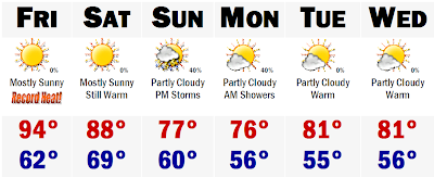
RECORD HEAT TOMORROW: Mid 90's Likely!

Record heat is on the way for tomorrow in SNE. Many areas will get to around 90 degrees, but areas just away from the coast by 5-10 miles and away from the high elevations will likely see temperatures reach 92-95 degrees tomorrow. Boston will likely top out at around 93 which will be a record high for the date. The beaches along the North Shore will likely stay in the lower to mid 80's, but whose complaining about that. What a way to start off the Memorial Day weekend. Of course, areas along the South Coast and the Cape will be much cooler with highs in the upper 60's to lower 70's, just because of the cool water influence. We stay warm for Saturday with highs in the mid to upper 80's before we cool into the 70's Sunday and Memorial Day with thunderstorms possible Sunday night and lingering Monday morning, especially south of the Mass Pike.

Thats all for now, enjoy the heat.

Tuesday, May 22, 2007

High Heat on the Way!

High heat is on the way to SNE the end of this week. Tomorrow will not be hot or even warm for that matter. Tomorrow will feature highs around 70 away from the coast, but right along the coast including the city of Boston, temperatures will likely reach 63-66 degrees by noontime and then fall back to around 60 with a seabreeze that may make it all the way to Route 495 by the end of the afternoon, bringing down temperatures from around 70 to the lower 60's. Then we go into the high heat. Thursday it moves in, mainly affecting the inland areas away from the coast by 10-20 miles with high temperatures rebounding into the mid 80's, but areas along the coast will likely stay in the upper 70's to around 80. The Cape and Islands will likely stay in the mid to upper 60's throughout the period as a side note.

Friday we will really start to bake under mostly sunny skies. Temperatures for inland areas will likely push if not exceed 90 degrees. Many towns will make it into the upper 80's, including Boston and Providence likely seeing their highest temperatures for 2007. Highs in these two cities may make it to around 87 in Providence and 88 in Boston. Further inland, places like Bedford, MA will likely make it to 90-92 degrees and towns in southern NH will likely make it into the lower 90's as well. Concord, NH will likely see its second 90 degree reading for this season as well. Mid 80's are in store for Saturday before we cool down Sunday into the 70's before returning to the 80's for early next week.

This weather will make for great beach days for those who are already out of school and can get a day off work. Unfortunately, I am not one of the lucky ones. Those who do make it to the beach this week, enjoy because this will be the best late May beach weather that we have seen in a few years. Enjoy it.

Friday, May 18, 2007

May Nor'easter!


Wednesday, May 16, 2007

Severe Storms to a Cool, Rainy, and Raw Weekend

Here is the map of the TORNADO WATCH that I mentioned earlier. This is courtesy of WHDH Boston. As you can see, much of interior SNE is under this watch. At this moment, I feel that the threat for tornadic thunderstorms has passed, but the NWS out of Taunton has extended the Watch an extra hour as there are now some major severe storms ripping through Massachusetts at this time. The biggest threat will most certainly be the heavy rainfall. Worcester picked up 1.3" of rain in a 45 minute period earlier this afternoon. It has sure been a wild afternoon for severe weather here in SNE today.

Cool weather is going to be the rule the next several days as we will go into a marine weather pattern with a raw NE breeze through the next several days. This means that we won't see the sun until early next week. Tomorrow will be a mostly dry day, but it will be overcast and very cool with highs struggling to get out of the 40's in eastern New England. A few spots west of Worcester will likely reach 50-55 degrees. Then a powerful coastal storm will get its act together along the eastern seaboard and inundate us with heavy rain for about 36-48 hours and it will be extremely cold with highs in the mid 40's for eastern New England on Friday and Saturday. Local flooding will be possible as the ground will be very saturated. Many areas have received between 1-2" of rain today and tack on another 1-3"+ from this weekend's storm, there could be some issues.
That will be all the updates for today, enjoy the storms and stay warm the next few days.

Severe Weather This Afternoon

Much of SNE is under the gun for strong to severe storms with heavy rainfall and frequent lightning. Many of the storms have already pushed into SNE with heavy street flooding type rainfall.

There is a TORNADO WATCH in effect for Worcester County on westward through all of central and western MA and CT for the possiblity of some rotation in some of the strongest storms. Winds at about 10,000 feet are anywhere from 50-70 mph sustained so any strong storm could tap into this wind field and drop some branches and small trees with a chance of rotation, especially in SW CT. The severe threat is reduced in NE MA mainly because we never got into the warm, humid air. Much of the North Shore stayed north of the warm front and stayed in the mid 60's all day, while areas to the south of the front saw temperatures all the way into the lower 80's, fueling the storms.

The Tornado Watch for western New England is in effect until 6PM, when most of the heaviest storms should be moving off the coast. On another note, the air is extremely cold aloft and this raises the chances of some small hail to be mixed in with the heaviest of thunderstorms as well. Its a hectic afternoon, so be safe and if you are on the ballfield or the links and see the sky turn black and hear thunder off in the distance, get inside to either a car or other type of shelter and heed warnings from the NWS and other media outlets.

Thats all for now. Be safe in this first real day of severe weather for the spring of 2007.

Sunday, May 13, 2007

Saturday, May 12, 2007

Some Frost on the Lawn

This graphic is from Accuweather and shows the frost and freeze potential for tonight and tomorrow night. It shows that the frost/freeze potential will move into Hartford, Providence, and just outside of the heat island, Boston, by tomorrow night. Temperatures tonight will cool enough in the valleys of SNE for some scattered frost, but there will be more frost on Monday morning here in SNE and both days in NNE. Temperatures in the colder valleys of NNE tonight will drop to between 28-34 degrees. SNE valleys will drop into the lower to mid 30's, but the heat island of Boston will remain about 10 degrees warmer with lows never really falling below 45 degrees. Tomorrow night, temperatures will drop into the lower 30's in SNE's valleys. This will cause some more widespread frost, so be sure to bring in those sensitive plants because some of those coldest bogs and valleys will likely drop to between 30-32 degrees for at least a couple of hours on Monday morning (3AM-5AM) Thats all for now.

Seasonable May Week Ahead

Sorry I haven't been able to post in a while, but I'm back and we got that sizzling week that I forecasted some 10 days ago. Maybe it didn't get to that 90 degree mark in Boston or Providence, but it did hit 90 this week in Concord, NH and many of Boston and Providence's suburbs reported temperatures near 88-89 degrees on both Wednesday and Thursday. So, I don't think it was an absurd forecast that some called me out on. Numbers may have been a little too high, but were pretty much in line with what we actually saw in the 6 day period.

That said, another awesome cool Sunday is on tap for tomorrow. Happy Mother's Day to all the mothers out there as well. It will be gorgeous with highs in the lower 60's with a light NE breeze keeping the coast crisp with highs in the upper 50's with crystal clear skies. Monday will warm up a tad into the lower 70's with abundant sunshine, but Tuesday will be this week's hottest day with temperatures easily topping 80 degrees in many locals and if the clouds don't fill in until later in the afternoon, temperatures could easily top out in the mid to upper 80's. It will also be very humid and this will spark off some heavy showers and thunderstorms, similar to what we saw yesterday around noontime in Boston. However, a ripple of low pressure may develop along the stalling front and give us a cool steady rain on Wednesday that could actually be a beneficial soaking that we most desperately need believe it or not. We'll have to watch this possibility.

We clear out slowly and by the end of next week, we will be back into the sunshine with seasonable mid-late May temperatures, in the 70's!

Thursday, May 03, 2007

Frosty Mornings to Sizzling Heat Next Week

Not very much time to talk right now, but it looks like we are done with rain for now. Expect dry conditions to dominate right through the next 7-10 days with limited chances of a few showers later in the period. Temperatures are on their way down for the short term. Tonight there is a Frost Advisory for areas south of the Mass Pike as temperatures will get to between 31-34 degrees in lower valleys and may cause some frost on new tender vegetation. We all could get frosty the next three mornings with temperatures cool, and even cooler on the coast with temperatures not getting out of the 50's the next few and on Sunday, Gloucester and Logan Airport may struggle to get out of the 40's for highs.

Then the tides change and we fly head first right into summer, warming up to near 80 on Monday, mid 80's on Tuesday and then flirting with 90 on Wednesday and perhaps again on Thursday before cooling down next weekend a bit into seasonable levels with the passage of that infamous New England backdoor cold front, that are inevitable with early spring heat.

Enjoy and if your lawn is looking like mine, get out there and cut it this weekend because next week's going to be a SCORCHA!