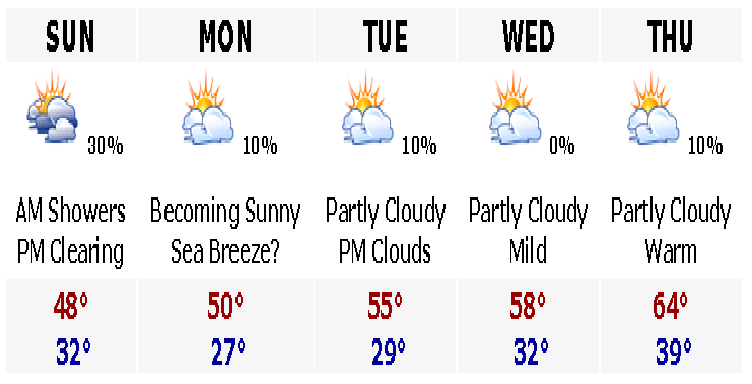
Tuesday, March 28, 2006

70 By Friday


Tonight will be one last very cold night in the suburbs of Boston, with lows in the middle to upper 20's. Closer to the urban heat island, expect lows in the mid 30's. Tomorrow will rebound nicely into the low 50's at the coast, upper 40's Cape, and near 60 inland by just a few miles. Thursday, only sea breezes will be felt on the Cape and Islands as a southwest wind will dominate. Elsewhere, expect highs in the middle 60's. Upper 60's to around 70 are likely on Friday, before a cooldown on Saturday with some rain showers. Expect some rain, but nothing big. Cooler weather to round off the weekend.

More later.

Monday, March 27, 2006

VERY HIGH FIRE DANGER


The fire threat is extremely high. It will remain high through the rest of the week until we get a good soaking rainfall, which does not look likely anytime soon. Saturday's rain will be light and spotty.

Sunday, March 26, 2006

Breaking Out the Shorts and Flip Flops by the End of the Week?


Looking at the 5 day and immediately your eyes are drawn to the end of the week. That is no typo. We will be well into the 60's on Thursday and even possibly flirting with 70 on Friday afternoon, even all the way to the beaches. Saturday may also be very warm as well, as some towns may be in the 70's.

Temperatures tomorrow will range from the upper 40's on the Cape and the coast, including Boston, to the lower 50's away from the influences of the coast inland. Tuesday will be a few degrees warmer as most areas will reach the low to mid 50's. Wednesday will again be a few degrees warmer than Tuesday as highs will manage the mid to upper 50's. Like a broken record, highs on Thursday will become even more springlike. Expect lower to middle 60's areawide. Only place that may be cooler is the Cape and Islands as any wind direction there is an ocean wind and with water temperatures in the lower 40's, expect temperatures to remain in the upper 40's to around 50 throughout the week. You will appreciate your personal air conditioner in the summer months as in the middle of heat waves up here in Boston with temperatures in the 90's, the Cape is most often in the mid and upper 70's. Friday comes some real warmth as many places, especially metrowest including Bedford, Natick, Lawrence, and southern New Hampshire including Nashua will all be flirting with 70. Boston may stay in the middle 60's. Out of the 5 day, Saturday looks to be the warmest day of the year with temperatures into the upper 60's and lower 70's for April Fool's Day. No snowstorms this April Fool's Day as we had 2-3 feet of snow back on April 1, 1997.

As for rainfall, or the lack there of, no hearty precipitation is in the forecast. I would bet that if we stay dry this entire week, Fire Weather Watches and Red Flag Warnings would be posted for increased and dangerous brush fire conditions. All of the dry vegitation from last year is just sitting there ready to be burnt. Keep that in mind as you head out and do your outdoor activities next weekend in the early summerlike warmth. Be careful with your cigarettes and follow the advice from the National Weather Service and local media forecasters as they will tell you of the dangers of brush fires later this week as the warmth becomes entrenched.

Enjoy the warm weather.

Warmth Only a Few Days Away For the East


This is a new format to the five day forecast, including more graphics and visuals. This is still a work in progress and will be adjusting it to my liking over the next several weeks. Any ideas, let me know.

For the weather, it looks like tomorrow will be the last in a string of raw cool days in the Southern New England area. After tomorrow morning starting with a few Cape sprinkles from an offshore storm, the area will clear up and we will see some partial sunshine in the afternoon. From then, it looks like warmer air will be here, not all a warmer airmass, but with the strong late March sunshine, temperatures will respond into the 50's almost every afternoon, barring a sea breeze.

By the end of the week, we may be talking about 60's here with strong SW winds. Enjoy the quiet weather while we have it because its New England and this March has been a breeze and you know we are bound for something shocking sometime in April. That is just the way it works here.

More on the forecast later.

Friday, March 24, 2006

Warming Trend?

After a high yesterday of 56 in Boston, today only managed to low to mid 40's with a strong sea breeze and cloudcover. Over Worcester County, there were even a few sprinkles and those sprinkles may turn to snow flurries overnight as temperatures cool through the 30's in western Massachusetts. Tomorrow will start out with a mainly overcast sky with some breaks in the clouds for a few peeks of sun. If you are tired of this boring cool and raw weather, your luck may be changing. It now looks like there will be a pattern change early next week to a ridge in the East. Highs should respond nicely, but do not expect temperatures to soar much above 50-55 in the next several days.

Quick Look at the 5 Day Forecast
Saturday
Mostly cloudy day with a few PM breaks in the clouds. Temperatures will remain raw with an onshore flow keeping in the Atlantic cool air. Highs generally 39-43 at the coast, including Boston, to 44-48 inland, anywhere several miles inland away from the influences of the water.
Sunday
Last of the real cool days. Morning starts out very raw with a few Cape sprinkles. Temperatures for early risers look to be in the lower to middle 30's. Expect temperatures to rebound nicely, except on the coast. Coastal highs of 40-44; inland highs in the upper 40's to around 50. Overnight skies will generally become clear and temperatures overnight Sunday will be seasonable in the upper 20's to lower 30's.
Monday
More sun than clouds and warmer. A light sea breeze may set up for areas of Cape Ann, Boston, and the Cape, where if it does expect temperatures in the lower to middle 40's. Otherwise, all other areas will see highs generally rebound to 50-56 with the warm late March sun.
Tuesday
Most sun in the morning then increasing clouds later in the day towards the afternoon. Expect highs in the upper 40's and the possibility of rain showers later at night which may continue as snow showers in the mountains on Wednesday morning.
Wednesday
Clearing and back to tranquil weather. Turning mostly sunny and with the warm and high nearly April sun angle, temperatures will soar to 55-62 areawide, except coastal areas where a sea breeze may cap temperatures around 45. Otherwise, it looks like this will be the beginning of a prolonged warm spell, seasonable warmth at least.

Friday, March 17, 2006

Jury is Out on Tuesday Storm

Well, if you have not been by any tv lately, there has been rumblings of a possible storm, east coast storm, around here on Tuesday of this upcoming week. Right now, I would put my money on "Out to Sea," and no storm here on Tuesday, but it must be noted that there is a possibility that snow could be in our forecast. Here are the two main scenarios for the storm...

Scenario 1
The Polar Jet remains over our area because of the stubborn polar vortex that has been stuck around Nova Scotia the past few days that has been keeping the cold air coming in to our area with brisk NW winds. The polar jet would go through New York City and prevent the storm that will be coming at us from the Tennessee Valley from penetrating the cold dry dome of air over New England. This storm will ride the Southern Jet Stream, the moist one, and head out to sea around Washington D.C. The Mid Atlantic would be the northern edge of the storm's precipitation shield and the very northern edge might be in the form of snow around Philadelphia, with very light non-accumulating snow. Farther north, New York, Hartford, Providence, and Boston would see nothing more than a few passing clouds.
Scenario 2
The Polar Jet and the Southern Jet combine around the southern New Jersey coast and a monster storm develops into what we would call a "classic" Nor'easter. Heavy snow would be likely from Philadelphia to Boston and southern New Hampshire. Cold air would be in place for this to be a mainly snow event, with only the possibility of mixing with rain or sleet on the Cape and immediate coastal plains. This would be a big one. The polar vortex would move far enough out of the way to not be a major player and let the storm ride up the eastern seaboard with an impressive shield of snow and wind. Now, as this is a very low probability of occuring, it is worth noting because this is an extremely high stakes forecast. This possibility of a storm early next week is not likely, but if it was to occur, it would create havoc.
Either scenario, travels will be hampered in the central states on Sunday night through Monday as heavy snows are likely in Nebraska, northern Kansas, southern Iowa, northern Missouri, and into Illinois and Indiana. Snow accumulations for these areas look to be on the order of a general 4-8", however, there could be a band of snow to set up shop in northeast Kansas and northwest Missouri where over a foot of the white stuff could fall. Any trips to Kansas City, a good five inches or more is likely. I wouldn't be surprised at all to see winter storm watches and snow advisories to be posted for these areas later on tomorrow or early Sunday.
Quick 5 Day Outlook
Tomorrow
Partly sunny and continued breezy from the NW. Morning temperatures will be frigid in the mid 10's; suburbs, to around 20 Boston. Afternoon highs generally in the mid 30's.
Sunday
Continued mostly dry and partly cloudy. Morning cold in the 20's. Afternoon highs in the middle 30's. Chance of flurries in the evening. Most places will stay dry.
Monday
Calm before the storm? Mostly sunny and chilly again Morning temps in the 20's and afternoon highs in the upper 30's. Possible increasing cloudiness in the afternoon. All depends on the storm track.
Tuesday
Day of the storm, if it would happen. Chance of snow, especially south. Low chance, 20 percent. Cold. Highs in the middle 30's. Morning lows in the middle 20's.
Wednesday
Day of the dig out? Unlikely. Moderating temperatures. Morning lows still in the 20's, but afternoon highs rebounding into the lower 40's. Middle 40's down on the Cape. Later in the week, it looks like the cold pattern will flip back and we will be basking in the warmth again with temperatures in the 50's.
More later on the possible winter storm and cold weather for the next several days.

Wednesday, March 15, 2006

Tranquil Times Ahead...At Least Concerning the Weather

A snowy Wednesday for some of us. Snow showers and squalls were pretty much with us all day. The snow started here in Woburn, off and on, around 1 PM and lasted until about 6 PM. All said and done, we managed to get a dusting of snow on the cars, porches, and grassy surfaces. Spots in Litchfield Co., CT, and the Berkshires of MA may see three or four inches of snow. That is about as much action as we are going to see as the next several days look to be very quiet. The possible St. Patrick's Day storm is going to go well south of us and may give some light rain and snow to the nation's capitial. In fact, the storm will be at its peak in southeastern Minnesota and southern Wisconsin and northern Illinois as a good 6-9" of snow is possible there.

Around these parts, a pattern change has been under way and we are going back to the Greenland Block weather pattern of February and early March. Highs the rest of this week and into next look to be below normal, but with the Greenland Block, there will be no chance of storms in this period, as if there was, they would be in the form of snow.

Quick look at the 5 Day Forecast
Tomorrow
More sun than clouds, still breezy. Morning temperatures in the upper 20's. Afternoon highs in the upper 30's to lower 40's. Coolest in Worcester County.
Friday
Continued cool and tranquil. Storm stays well south of our area. Possible high cloudiness on the South Coast. Morning temps in the 20's; Afternoon highs in the 30's.
Saturday
Sunny and cool. Still a northwesterly breeze. Chance of northern New England mountain snow flurries/showers at night with a reinforcing shot of cold air. Morning temps in the 20's; Afternoon highs in the mid and upper 30's.
Sunday
Cold morning temps in the upper 10's to lower 20's. Continued tranquil weather and breezy conditions. Mountain snow flurries. Afternoon temperatures in the lower to mid 30's.
Monday
Quiet weather continues. Morning temps in the lower to mid 20's; Boston upper 20's. Afternoon highs around 40.
I will probably not be able to for a while as other responsibilities have come up, but I will try to be back on for an update this weekend. Enjoy the tranquil weather.

Sunday, March 12, 2006

Cold Times Ahead...

You knew that this amazing warmth couldn't last. It looks like we have until Tuesday until the spring warmth is all but a distant memory. First, the rest of today looks to be warm with highs generally around 60. Tomorrow will start off mainly dry but showers, heavy at times, will move in during the afternoon and continue overnight and into part of Tuesday. QPF from this looks to be over one inch! Basically, tomorrow and Tuesday look to be mild, but unsettled. Later Tuesday a strong cold front will move through the area with a possible thunderstorm or heavy shower and then colder air will move into the area to end the week. Wednesday looks to be cold with highs generally in the upper 30's to around 40. A few upslope snow showers are possible in the Berkshires and on the western slopes of the Green Mountains in Vermont. Thursday will be seasonalbly chilly with highs in the lower 40's. Then the interesting part comes Friday, St. Patty's Day, as we will have a potential Nor'easter around these parts to dump a whole heck of a lot of snow. More on this later as the computer models are still all over the place with this, but as the NAO looks to be going from positive to negative at this time, it would favor a high QPF event and most of this would be in the form of snow.

More later...watching the BC/DUKE game right now.

Wednesday, March 08, 2006

Weekend Outlook

The overall pattern for the next several days looks to be that of unsettled and warm. Tomorrow afternoon will bring our first chance of rain, which may start as a mix of freezing rain and sleet in western MA and western CT where winter weather advisories have been posted for slippery conditions. After that, the weekend looks to be very warm.

Day by Day Breakdown
Tomorrow: Chance of showers, especially in the late morning and early afternoon through the evening. Highs in the 40's; upper 30's southern NH. Some morning ice is possible well west of Worcester.
Friday: Sun and clouds mixed, chance of a shower. Gusty SW winds and amazing warmth! Highs lower to mid 60's.
Saturday: Partly cloudy. Highs in the upper 50's.
Sunday: Partly to mostly cloudy. Chance of a few widely scattered rain showers. Continued mild. Highs upper 50's to 60.
Monday: Another warm day! Mixed sun and clouds. Gusty SW winds. Mid and upper 60's!
Tuesday: Transition day...warm AM and then showers with gusty winds as a cold front pushes through that will bring us back to reality. Until then, highs should range from the upper 40's to lower 50's. Still above average.
Wednesday: Back to reality. Gusty NNW winds and the chance of snow flurries. Highs in the 30's north; 40's Cape.

Saturday, March 04, 2006

Surging Warmth

Warm weather is on the way...this week will be the a seasonably chilly week with highs generally in the lower to middle 40's, until Friday. First, I want to mention the storm that occured Thursday afternoon that brought 6-8" of snow for those of you down south into RI and CT and the Cape and the Islands. There was a sharp cutoff of the snow as predicted and from Boston on northward, NOT a flake of snow, just as predicted. That snowcover will have a short stay with us, if most of it has not already melted with the high March sun angle. Now to the details on the surging warmth later this week...

Friday, some showers of RAIN may move into the forecast with highs into the low to mid 50's and temperatures will hold in the lower 50's throughout the night Friday as a strong warm front moves through the area. Saturday looks to be that windy day that you get in March will warm moist winds whipping the clouds for a changeable sky with fast moving clouds. Highs, at this point look like they could be into the 60's for much of Southern New England, barring a sea breeze, which is unlikely, but a SE wind could set up keeping the coast possibly much cooler as the water temperature is a chilly 38. However, inland locations could possibly soar into the mid 60's here. 65 looks to be a good number at this point. Cities south of us could see much higher temperatures. New York City, after having a snowstorm last week could hit 70!

Philadelphia could manage the lower 70's and Washington DC and Baltimore could be dealing with highs well into the 70's with 80 not out of the question.

No, this is not a dream, this is REAL. However, looking at the long range charts, a quick cooldown, especially north into SNE could mean this is just a one day surge of warmth as temperatures Sunday look to cool into the 40's again. However, flowers will pop and all the signs of spring will be around us. Spring is right around the corner.

Wednesday, March 01, 2006

Heavy Snow For Some...Not Boston Though


Joel, you suckered me into raising the snowfall accumulations for most. Still going for nothng more than a flurry north of Boston. Providence will be on the line with about three inches of accumulation. I am pretty confident with these numbers.