Monday, July 31, 2006

Heat Indices to 115 by Wednesday


Amazing heat is on the way for all of southern New England the next two to three days. Tomorrow will be the pregame for the record heat that we will experience on Wednesday when much of southern New England will be topping into the lower 100's. Heat indices, the excessive temperatures along with dewpoints in the 72-78 degree range will make the real feel temperature feel like 100-105 degrees tomorrow and more like 110-115 degrees on Wednesday. That is why all of southern New England except the Cape and Islands are under an EXCESSIVE HEAT WARNING at this time. It will be a threat to your health and could unfortunately cause some heat related deaths, especially with the elderly living alone without air conditioning.

Thursday will be the transition day to cooler times with scattered showers and thunderstorms in the afternoon. Should these storms disrupt the Sox or Spinners games? Well, at this time it will be a close call, but I'd say keep all plans intact.

Cooler air invades Friday with highs in the upper 70's to around 80 with lows in the upper 50's in the suburbs to lower 60's in Boston. It will be a welcome relief.

Tropics are becoming interesting with several impressive tropical waves, especially one heading towards the Windward Islands, but nothing is posing an immediate threat, so just stay tuned.

Saturday, July 29, 2006

RECORD HEAT

The five day forecast has all that you need to know. When you say that upper 80's is a break from the heat, you know that it is going to get really hot. Monday through Thursday will be very very hot. Temperatures should be in the mid to upper 90's on Monday and Tuesday. Now it looks like the hottest day will be Wednesday when it looks like 100 will be a common number for the day's high temperature. It should be absolutely brutal with heat indices up over 110 degrees.

More on this dangerous heat wave later.

Friday, July 28, 2006

Dangerous Heat Next 5 Days

Your eyes are not deceiving you right now. Those are the actual forecast highs for the next five days for the Boston metro area. This looks more like a five day for Dallas, Texas during the month of July. Tomorrow will be consecutive day number three of 90+ making it Boston's first official heat wave since August of 2002. Sunday will "cool" into the upper 80's, probably not hitting 90 too widespread. A few towns in the CT River Valley may flirt with 90, but it will be the exception. However, Monday the heat comes back on full blast with highs all the way into the upper 90's, with a heat index making it feel more like 105 degrees.

On Tuesday we may actually hit the century mark somewhere in eastern New England. Strong SW winds will be prevalent and the sun will be baking and highs will likely be in the upper 90's to around 100 degrees even in the city of Boston! More heat Wednesday.


Amazing heat is in the forecast for tomorrow. Looks like near record high temperatures are possible for much of southern New England. Highs will easily top 90 and some areas could be flirting with the mid and upper 90's. SW New England may even flirt with 100 degrees tomorrow afternoon as the graphic above suggests. As you can see from the graphic, the heat is not just our problem, but the entire nation is dealing with this unrelenting heat wave. California has seen, at this time, 132 heat related deaths due to the excessive heat. Temperatures in interior California topped out over 100 again for about the 13th consecutive day. Places like Sacramento, CA have seen record high temperatures peak at about 111 degrees. Also, Death Valley, known for heat, managed to challenge the 130 degree mark. Thats even hot for Death Valley standards.

No break from the heat early next week as on Tuesday we may actually hit our peak high temperature of around 98 to 100 degrees. Wednesday will be hot as well, with highs in the mid and upper 90's again. The Monday through Wednesday stretch will likely be our second officical heat wave of the year for the city of Boston. The first one is underway right now. It started yesterday, Thursday and will continue through Saturday, cooling into the 80's Sunday. Next Thursday could make it a four day heat wave, but showers and thunderstorms could cause it to come just shy of 90 degrees. If Sunday were to make it to 90 in Boston, we could be talking about a 6-7 day heat wave. However, I don't think that will pan out.

Tropics? They are disturbingly quiet still, with no real action out there to be concerned with. There is a tropical wave way out in the Atlantic about 1,000 miles SW of the Cape Verde Islands. No imminent threat for anybody at this time. We'll watch it though.

To sum it all up...

Be careful with all of the heat the next 5 days as it could get quite dangerous for the sensitive, especially the elderly. So keep an eye out for that. Otherwise just try to stay cool and enjoy this kind of weather because if you are new to New England, this does NOT last very long. We usually get our first frost in mid September and first flakes in the second or third week of October. Thats in two and a half months! So, enjoy the summer heat.

High Heat to End July '06


Not on the five day is today, Friday. Today is going to be hot and another oppressive day. Temperatures this morning are already in the mid and upper 70's. In fact Boston's Logan International Airport never made it below 76 degrees last night. Right now it is nearly half past seven and temperatures throughout SNE are in the 75-80 degree range with dewpoints in the 70-75 degree range. It is stifling.

The good news is that a cold front, in this case a drier air front, is coming towards the six state region from the NW from Canada. This will bump into our very unstable and volitile airmass overhead and trigger some heavy showers and thunderstorms, mainly this afternoon. However, looking at the radar, there is already a few scattered showers and thunderstorms around the area now, so anytime and anywhere is basically fair game today.

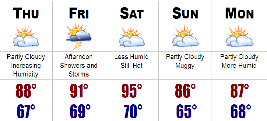
Before most of us get involved with the thunderstorms today, temperatures will easily rise another ten to fifteen degrees to get highs into the upper 80's to around 90. Yesterday Boston officially hit 91 degrees so if we do it again today it would be consecutive day number 2 and I believe 90 is a given for tomorrow's forecast.

Friday Thunderstorm Outlook

When: Anytime, but more likely after 11AM NW to 2PM Boston to 3-5PM Cape
Where: Everyone is fair game
Threat: Possibly severe...damaging winds, large hail, frequent lightning, torrential downpours
Rainfall: Generally 0.5" to 1" (Locally 2"+ in slow moving thunderstorms)

Will the Sox game get in tonight, 7:05PM against the LA Angels?

Right now I would say it will probably get in, possibly with a delay. I cannot be sure if a thunderstorm will be over Fenway at first pitch, but I would say that most of the action will have passed by Fenway Park by 7-8PM. My guess is there WILL be a game tonight.

I should also mention that the Patriots are starting up their summer camp down in Foxboro today. First practice is at 9AM and it should feel like south Florida as they get underway. Temperatures around that time in Foxboro should be about 81 degrees with a heat index more like 86. By 11AM temperatures should be around 88, barring a cooling thunderstorm, with a heat index around 95. If you are going down there to watch, which is a great thing, make sure you bring lots of water and stay as cool as you can.

5 DAY FORECAST BREAKDOWN

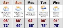
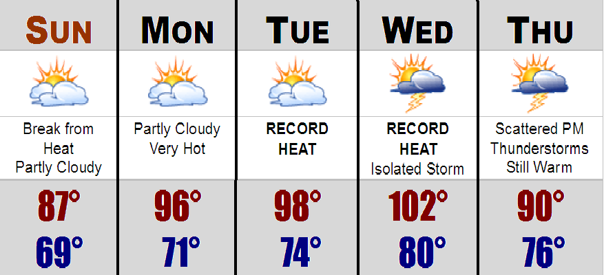
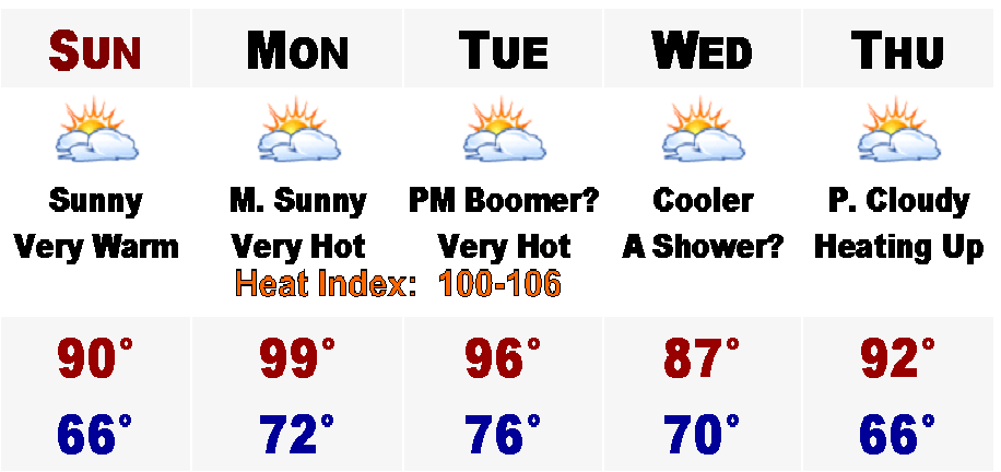
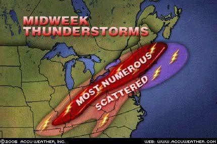
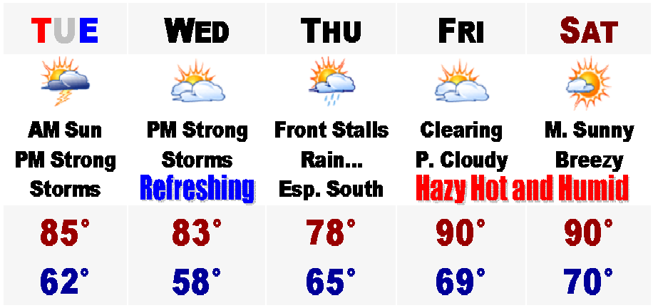
Tomorrow will be the hottest day of the next five with temperatures easily into the middle 90's. I would not at all be shocked to see a temperature of 97 in places like Nashua, NH or Hartford, CT. Boston will probably hover in the 94-96 degree range. It will be a different heat though. With a NW wind, all the humidity will be pushed out to sea, for now. Sunday will feature much cooler temperatures, generally in the mid 80's, but along the coast where a sea breeze may develop around noontime, temperatures will probably stay in the upper 70's to lower 80's, especially right on the beaches. Monday the heat will return as well as some humidity. Temperatures in the lower 90's likely with ample sun. Tuesday will be very hot once again. Temperatures back into the mid 90's. A shower or thunderstorm is possible for the evening, but that is dependent on a backdoor cold front from the NE. This front will determine the weather for Wednesday. If it stays north of us, expect highs back into the 90's, but if it passes by, expect temperatures in the mid 80's inland and 70's along the coast. We will have to watch this one. Either way it looks like it will be a decent day. Just remember these nice "complications" in the weather in January and February, 80's or 90's, because "complications" in the winter mean an inch of snow or does it come closer and give us 20"?

Anyway, stay cool today and stay in the AC. Today's thunderstorms may cause a Watch Box to go up for part of our area later today, so if it does, check just below the title where there is a banner that will tell you all the information you will need to know whats going on and where the watches and warnings are.

More on the forecast later.

Wednesday, July 26, 2006

Staying Very Warm

Hot again today, Wednesday, with highs once again in the upper 80's around southern New England. Dewpoints are on the rise today, however. Dewpoints are generally going to hover around 70 degrees until later on Friday and Friday night when a cool front will pass through the area, with the chance of a few scattered but very intense thunderstorms. So watch out for those.

Other than that, there will be not much weather to talk about in the next five days. Saturday the humidity will come down greatly, but it will still be very hot with temperatures in the lower to mid 90's around here. Sunday and Monday will cool down into the 80's, but even then will be above normal in the temperature department. Also, later Monday, you will start to feel an increase in the humidity, unfortunately.

More on this forecast in the days to come and if anything starts to brew in the tropics, you will be the first to know.

Friday, July 21, 2006

Rainy Weekend

Well, we are now in the last days of July. Last night Tropical Storm Beryl turned out to be a dud for the Cape and Islands with the peak wind gust to 44 mph on the island of Nantucket. Rainfall from this T.S. ranged from around a half inch to two inches. Nothing to write home about. Beryl is quickly moving away and is quickly becoming extratropical and becoming nothing more than an ordinary upper latitude storm system.

However, there is a cool front coming into the area and ahead of it there is warm and very humid weather out there. Temperatures, with the sun at the noon hour, have responded nicely into the lower to mid 80's with dewpoints around 70, making it feel very oppressive out there. Showers and thunderstorms are forecasted to develop this afternoon around southern New England, and a few of them may be severe, with strong gusty winds, torrential rains, frequent cloud to ground lightning, and even some small hail possible.

For tomorrow morning, tonight's storms will clear out before more showers and thunderstorms develop in the afternoon again. Again, the rain with these storms could be quite heavy and we are generally going to see anywhere between 1-2" of rain from all the storms from this afternoon until it all tapers Sunday morning, before skies clear and the humidity subsides for a little in the afternoon on Sunday with highs around 80.

Things will heat up again later next week, starting on Tuesday. Temperatures on Tuesday could manage to hit 90, and again on Wednesday and right now temperatures may just be a little shy of 90 on Thursday, but there is a possibility of heat wave number 2 in Boston's western suburbs next week. Boston will likely not see a heat wave as the influences from the 66 degree ocean water is much too strong to keep away early afternoon sea breezes cooling the town substantially, while just outside of Boston is baking in temperatures over 90. Along with the heat later next week, a few isolated thunderstorms are possible on Wednesday and Thursday.

7 Day Forecast Courtesy of CBS 4 Boston ~ WBZ ~ Viacom

Saturday, July 15, 2006

Heat Wave Grips Much of the Lower 48

Today's high at Boston's Logan International Airport was 89 degrees. That will make us start at day number one for the official heat wave as yesterday's high of 91 degrees will not be part of what could be our first official heat wave since August of 2002. We still could get a heat wave in Boston, Sunday through Tuesday.

Besides all that technical mumbo jumbo for records and stuff...to you and me...ITS DOWNRIGHT HOT OUT. Much of the lower 48 is under this Heat Wave. Today in North Dakota, temperatures throughout much of the state were in the 100-110 degree range. Further southeast into Chicago, IL, temperatures today were in the upper 90's to around 100 and tomorrow in the Windy City, the high could top 100 degrees. If you are looking towards the Rockies for relief from this heat, you would be mistaken. High temperatures for the cities of Denver and Salt Lake City tomorrow the 16th, will be around 100-105 degrees respectively. The only "relief" from the heat would be in Seattle, WA, as temperatures there have remained in the mid 70's with some marine air influence, keeping them out of this historic heat wave.

Blazing heat is definitely on the way with highs tomorrow in the upper 80's to around 90, add dew points around 70, and it will feel more like the lower to mid 90's out there tomorrow. Monday afternoon could be our hottest since last August when Boston hit 97 degrees. Up in the 5 day, I am calling for a high of 99 degrees, but that is for the hottest of areas, like Nashua and Concord, NH. More likely, Boston will top out around 94-96 degrees. That will be a similar forecast for Tuesday as well. Coupled with dew points in the lower to mid 70's, the real feel temperature will be more like in the 100-106 degree range.

Also, during this time, at night we will not really cool off. Tomorrow night, in the coolest areas, temperatures will fall into the upper 60's. In urban areas, like Boston and Lowell, temperatures overnight may remain in the lower to middle 70's. Monday night, overnight temperatures in the urban areas may stay in the mid to upper 70's! That is the normal daytime high temperature for mid June!

However on Tuesday there will be a cool front coming down from southeastern Canada that will touch off scattered showers and heavy thunderstorms. These storms will filter in some much drier air for Wednesday, but the temperatures will still remain on the warm side, mainly in the mid 80's.

Thereafter, expect the furnace to be put back on fully, with temperatures nearing 90 by late week, next week.

Stay cool.

Tuesday, July 11, 2006

Wild Tuesday...Tornadoes, Hail, Winds, and Torrential Rains..A Wednesday Repeat?


What an amazing day for weather here in southern New England! It was absolutely amazing. The day began with a severe thunderstorm in Rockingham Co., NH which quickly escalated into a Tornado Warning around midday. Reports of hail 3" in diameter in Exeter, NH! Also reports of a funnel cloud and possible touchdown as a brief tornado in Rye, NH at the same time. This area was absolutely hammered today with up to 5" of rainfall as well.

Then the area of focus was the North Shore of Massachusetts. Around 2:30PM, another Tornado Warning was issued for parts of Essex County. In Topsfield, MA there was a confirmed sighting of a funnel cloud, which Channel 7 News has gotten on picture in their special links above the forecast. Amazing photo.

Here in Woburn, MA, the rain, lightning, and hail was amazing. Vivid lighting and torrential rains were common from about noontime until 3:30PM. Hail of 1.25" in diameter was also seen here in Woburn as well. Just an all out crazy day. Rainfall totals here, just north of Boston in Middlesex and Essex counties ranged anywhere from 3-5" with these storms and more heavy rain is forecasted for tomorrow afternoon with possibly more severe thunderstorms as well.

Tomorrow will start off cloudy and very humid with temperatures right around 70 degrees. Then like today thunderstorms will start to develop, scattered, in the afternoon and then mesh into a general band of heavy heavy rain, with embedded thunderstorms, with even heavier rainfall. This will continue into the first part of Thursday and all said and done, anywhere from 3-6" of rain is likely here in the Boston metro area by Thursday afternoon.

Flooding will be quite likely around here tomorrow night and through Thursday. Street and urban flooding is definite during this storm's peak, but if we do indeed get up to a half a foot of rain over the areas that saw the 3-4" of rain from today, we could be seeing more substantial flooding. It is just something we will have to watch and see.


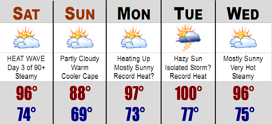
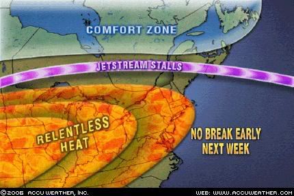
Anyhow, by Friday all the rain will become a distant memory as "drier" air will move into our region with the beginning of a HEAT WAVE likely as temperatures will top out around 90 by Friday and we will likely be in the 90's through the weekend with great beach weather and water temperatures are now starting to respond nicely as most are in the upper 60's to mid 70's.
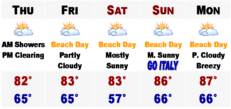
Will have any important updates if warranted tomorrow or Thursday with the possible severe thunderstorm and potential life threatening flood threat more likely on Thursday, as well as the great details of the hot weekend on tap for us that we greatly deserve.

7 DAY FORECAST IS COURTESY OF CBS 4 BOSTON-WBZ4

Wednesday, July 05, 2006

Many Great Days Ahead...

Hope your 4th was nice and you managed to dodge the showers and severe thunderstorms. Hearing reports out of Hopedale, MA that there was a microburst from a severe thunderstorm that had straightline winds in excess of 90 MPH. Hope everyone is okay as there were many downed trees. Elsewhere, many areas saw a quick hitting heavy rain with wind that went by and many communities got off their fireworks display without incident. However, Nantucket had to postpone their fireworks until tonight because of fog. I am not so sure that they will be able to get the show off tonight either because of the rain down on the Cape.

Speaking of the rain down on the Cape today, it is associated with the front that is pushing through the area. A little ripple of low pressure developed and is now bringing a shield of rain from the South Shore on southward. Expect the rain to gradually pull southward and the South Shore should start to dry out by now, this afternoon, while the Cape and islands may see a damp night for the vacationers down there. North of the Pike, it is totally dry with overcast conditions and tempertures near 80. Cape Cod will stay in the lower to middle 70's during today's mini rainstorm. Generally expect total rainfall to be under one inch.

After today, the weather will turn out to be perfect for all outdoor activities, including going to the beach. We will transition into a period of perfect weather with low humidity for tomorrow, Friday, and Saturday with highs generally in the 80's, even on the east coast facing beaches. Humidity will increase on Sunday, but it will remain dry and warm with highs in the mid 80's. I will be pulling for Italy to win the World Cup Championship then. Right now Portugal and France are in the 48th minute with France on top 1-0. We will soon find out if the Italians will be hosting the French in the 2006 World Cup Championship game.

Monday will feature the same weather as Sunday with highs approaching the upper 80's to around 90, except around 80 on the South Coast and Cape. The Islands will stay in the 70's.

Enjoy the nice weather upcoming later this week.

Monday, July 03, 2006

Happy Independence Day

What a day this third day of July has turned out to be in eastern Massachusetts. The air is dry and the temperatures are very warm inland with highs in the mid and upper 80's, but upper 70's along the coast with an afternoon sea breeze. Perfect.

Out in western New England, there is currently a Severe Thunderstorm Watch for the potential of severe thunderstorms until 9PM tonight. There were a few Severe Thunderstorm Warnings in northern CT and RI earlier, but those storms have started to weaken. To the south, dew points are starting to rise already with dew points in the mid to upper 60's.

Tomorrow will feature higher humidity and the heat will be with us for the Fourth. Highs should manage the lower to middle 80's before showers and thunderstorms start to develop anytime after 2PM. The window of highest threat for strong to severe thunderstorms, with frequent lightning, large hail, and strong gusty winds in excess of 60MPH, with likely be between 2PM to 8PM. At this time, I believe the NWS will likely hoist a Severe Thunderstorm Watch for much of southern New England as we will all be under the gun for severe weather to hamper Fourth celebrations.

For Wednesday, we will dry out for a time with highs managing the 80's once again before showers develop overnight as the front that went by on the Fourth will try and sneak its way back up here during this time. For Thursday, right now computer models have rain with the front just offshore of the Cape with a little area of low pressure on it. How close to this front will determine if we see organized masses of showers or just a plain steady rain. One computer model, the NAM, has anywhere between 1-2" of rain for areas to the south of the Mass Pike on Thursday morning, with areas to the north seeing much less rainfall. This is the most threatening of the computer models and the more trusted GFS model only has a few showers on the Cape for Thursday, with areas to the north of here even seeing some sunshine. Right now, I am going to side with the drier of the two scenarios at this point, but just mention that there is the possibility of some rainfall in the 5 Day.

After this speed bump in the forecast, Friday will feature clearing skies and temperatures will rebound back into the upper 80's to around 90, except around 80 on the South Coast and Cape. Humidity will also increase at this time and the heat looks to continue into this upcoming weekend with the nation east of the Rockies possibly going into a prolonged Heat Wave of greater than 6 days, which means once the 90's arrive on Saturday, they might be with us for a while afterwards. It is just something we will have to stay tuned to, just to see if this indeed does occur. At least summer has arrived and all these rainstorms seem to be a thing of the past. Hopefully. Just watching Thursday...