Monday, January 30, 2006

Dodging a Bullet


Well, we are really going to be dodging a POWERFUL ocean storm tomorrow. It is going to miss hitting us by only about 150 miles of being a major Boston snowstorm. Wow, snowfall totals could have been amazing and the coastal flooding, catastrophic. Still, we will see minor to moderate coastal flooding as the tides are astronomically high. Expect some splashover if you live right on the coast.

Regarding the snow, the storm will start as mostly rain inside of Rt. 495 and then by late afternoon may change to a brief period of light to moderate snow, generally accumulating 1-3" regionwide. A few spots in southern Worcester Co. and northern Rhode Island may see an isolated 4" amount, but that will be the exception. Generally, nothing much to talk about.

This week will generally be mild with some more light mixed precipitation on Thursday and then a bigger storm on Sunday, but this looks to be an inland runner with mild conditions and potentially heavy rain. One storm heads to far east to give us any snow then the other heads too far west to give us any snow. It has been that kind of winter.

Update Later.

Saturday, January 28, 2006

Sorry Snowlovers

Sorry to say that with the newest information from the GFS, it looks like the Tuesday storm looks much weaker and develops much further out to sea, only bringing light rain/snow showers to the Cape and the Islands with little to nothing further north.

This "OUT TO SEA" trend has been going for about 12 hours now and if it continues and all day tomorrow still takes this thing out to sea, I think I will lower my alert level somewhat. Still looks likely that we will see rain showers move in on Sunday afternoon and into Monday.

With these big storms they generally tend to look like they are going to hit us, the computer models back off entirely and then sometimes they go back full force right before the storm, 36 to 48 hours. So do not be surprised if this comes back into the forecast, but for now I am only calling for us to be fringed by this storm with very little accumulation.

Sorry snowlovers, including myself, I was really looking forward to the possiblity of a good snowstorm. Seems like these potential big storms always have to miss us. Oh well, still have about 2 months left of wintertime.

Friday, January 27, 2006

Nice Saturday...Stormy Week Ahead

Well, I told you that I would not be back unless something big was on the way, well there is sometihng pretty major developing and it is starting to make even the most experienced meteorologists sweat a little.

Before that, we have got tomorrow. Remember last Saturday with temperatures in the 50's to near 60, well we may not be that warm, but highs around 50 are very possible tomorrow afternoon. Then comes Storm #1 on Sunday with mostly rain showers, light, and will continue into Sunday night. Northern New England may see a mix of light rain, sleet, and snow and may even see a light accumulation of snowfall on the order of a couple of inches? What this storm will do is bring down some cold air from Canada and will bring this nice chilly air all the way down to the South Coast and Cape.

This will set the stage for a potential major Nor'Easter on Monday night through Wednesday afternoon! Yeah, this could be a long duration storm. In between, during the day on Monday, colder air will be draining into the area with temperatures generally settling into the lower 30's and we may even see some light sleet or snow ahead of the main storm. So, Monday will be the calm before the storm.

Then comes the fun part....

This is a graphic, courtesy of Accuweather.com, of the potential major storm heading in on Monday night. Looks very ominous. Look at the storm ingredients. A strong storm developing along the Del Marva. Colder air draining into the storm. Abundant Atlantic moisture to be thrown into the rapidly developing storm. And not in the graphic, but there will be a high pressure system in SE Canada that will keep the cold air in place making this mostly a snow event for much of SNE. Only exception will be the South Coast and Cape, where some rain or sleet may mix in with the snow. However, I have to tell you that with each new run of the models, it looks that even there, it looks to be mostly a snowstorm. North and west of Providence and Boston, I am almost certain that this storm will be mainly white.

This graphic also outlines the threat of this potential Nor'Easter coming early next week. Looks like it could be getting very interesting. Way too early to be throwing out any snowfall amounts, but being extremely safe I would say the potential exists from the suburbs of Philadelphia to New York City to Boston and southern New Hampshire for more than six inches of snow. This is starting to be more likely. This is an extremely large area to see that much snow widespread. Someone in this area could wind up with well over a foot. Stay tuned!!!

Thursday, January 26, 2006

Nice Day

I will be away for a while, for the rest of today, tomorrow and probably Saturday, but if any unexpected weather situation arises, I will try to get online.

All the complex, wintery weather looks to hold off until Sunday night into Monday and then again on Tuesday. We could be seeing some decent snows. Thats your fair warning. Don't say I didn't tell you.

Anyway quick forecast is tomorrow will still be chilly with highs in the mid-upper 30's and then this weekend highs will rebound into the upper 40's! Enjoy because this nice warm weather does not look like it is going to last.

By the way, many areas inside I-95 along the eastern coast of Massachusetts received anywhere between a half inch to an inch and a half last night with some coastal snow showers. Interesting...

Talk to you again on Saturday or Sunday.

Wednesday, January 25, 2006

Morning Snowfall Totals

MASSACHUSETTS...

BRISTOL COUNTY
TAUNTON 0.3" 652 AM 1/25

ESSEX COUNTY
SALEM 3.0" 1229 PM 1/25
TOPSFIELD 2.8" 1030 AM 1/25
METHUEN 2.2" 734 AM 1/25
ROCKPORT 2.2" 1231 PM 1/25
PEABODY 2.0" 1000 AM 1/25

MIDDLESEX COUNTY...
WAKEFIELD 2.8" 955 AM 1/25
WOBURN 2.5" 1000 AM 1/25 by me
FRAMINGHAM CENTER 1.7" 548 AM 1/25
MAYNARD 1.2" 649 AM 1/25

NORFOLK COUNTY...
MILTON 1.6" 813 AM 1/25
NORWOOD 1.0" 623 AM 1/25 NWS EMPLOYEE

BOSTON 2.9" as reported on Accuweather.com

Scattered snow flurries and snow showers are possible tonight here in eastern MA, mainly north of the Pike and out near the Quabin Res. A coating of snow is possible in any given location in SNE overnight tonight and into tomorrow morning so you may have to dust of the car tomorrow morning.

Possible snow Monday now looks like a light to moderate rainstorm and highs this weekend could soar to near 50 on Saturday and in the mid-upper 40's Sunday before the rain, and plain rain, moves in on Monday with highs in the 40's. Colder air may move in after that, but we will continue to be in this mild pattern with a few day breaks in the snow and cold as we have just went through.

Mild pattern will dominate...

More on this tomorrow.

Very Little Snow...Bad Timing

I am lowering amounts from earlier this afternoon. The snow will still fall early on around dawn, but we may only see about an inch maybe two in eastern Massachusetts north of Brockton and away from the coast. South and west from there, you will be lucky to get a dusting to one inch.

Southeastern Maine...2-5" is now forecasted for you guys...maybe not the 4-8" as the HEAVY SNOW WARNING says. Isolated spots may see up to 6".

Tuesday, January 24, 2006

Snow Advisory

Here is an excerpt from the contents of the Snow Advisory...

...SNOW ADVISORY IN EFFECT FROM MIDNIGHT TONIGHT TO 5 PM ESTWEDNESDAY...THE NATIONAL WEATHER SERVICE IN TAUNTON HAS ISSUED A SNOWADVISORY...WHICH IS IN EFFECT FROM MIDNIGHT TONIGHT TO 5 PM ESTWEDNESDAY. THIS ADVISORY INCLUDES NORTHWEST AND NORTH CENTRALMASSACHUSETTS...AS WELL AS THE MERRIMACK VALLEY OF NORTHEASTMASSACHUSETTS AND ADJACENT SOUTHWEST NEW HAMPSHIRE.BRIEFLY HEAVY SNOW SHOWERS ARE EXPECTED TONIGHT AS A STRONG COLDFRONT CROSSES SOUTHERN NEW ENGLAND. THE SNOW SHOWERS WILL REACHWESTERN NEW ENGLAND AROUND MIDNIGHT...NORTH CENTRAL MASSACHUSETTS BY2 AM...THEN THE MERRIMACK VALLEY BY 5 AM. THE SNOW SHOWERS WILL LASTABOUT 2 TO 4 HOURS AND GIVE ACCUMULATIONS OF 1 TO 3 INCHES ON AVERAGEBY DAYBREAK.LOW PRESSURE IS EXPECTED TO FORM NEAR THE SOUTH COAST OF NEW ENGLANDWEDNESDAY MORNING...THEN STRENGTHEN AS IT HEADS OFFSHORE. THIS WILLBRING ANOTHER ROUND OF SNOW TO SOUTHERN NEW ENGLAND WEDNESDAY...WITHTHE GREATEST AMOUNTS IN THE MERRIMACK VALLEY WHERE THE SNOW WILL LASTLONGER.BY THE TIME THE SNOW ENDS LATE WEDNESDAY...TOTALS OF 2 TO 4 INCHESARE EXPECTED THROUGHOUT NORTHWEST AND NORTH CENTRAL MASSACHUSETTS.HIGHER TOTALS OF 3 TO 6 INCHES ARE LIKELY FROM MANCHESTER TO NASHUANEW HAMPSHIRE...AND INTO INTERIOR MIDDLESEX AND ESSEX COUNTIES INMASSACHUSETTS INCLUDING LOWELL AND LAWRENCE. TOTALS IN COASTAL ESSEXCOUNTY WILL RANGE FROM 2 TO 4 INCHES NEAR CAPE ANN TO AS MUCH AS 6INCHES NEAR THE NEW HAMPSHIRE BORDER.PLAN ON A SLOWER THAN NORMAL COMMUTE WEDNESDAY MORNING. SNOW WILLCREATE REDUCED VISIBILITY AND SLIPPERY ROADS.STAY TUNED TO NOAA ALL HAZARDS WEATHER RADIO OR YOUR LOCAL MEDIA FORUPDATED INFORMATION.

Heavy Morning Snows!

Well, if you thought winter was O-V-E-R last week when we enjoyed April-like temperatures in the 50's and 60's in the middle of January, you were wrong. Winter is back and stronger than ever. More snow, heavy at times, is in the forecast for tonight into early tomorrow morning ending around 5-7 AM, but scattered snow showers and flurries may linger all day, or worse...
Let me explain...
An Alberta Clipper, which originates in Alberta, Canada, hence the name, will be moving in on us from the NW, or Great Lakes States. Associated with this very dynamic storm is an arctic cold front that will spawn high winds and during our squalls tonight could produce blizzard like conditions for a short time. This Alberta Clipper will develop a secondary storm around the Cape Cod Bay area and develop rapidly. If this storm were to develop extremely rapidly and throw back moisture into eastern New England, we would be talking about a pretty substantial snowstorm here with snowfall accumulations on the order of 6" again, which is still not out of the question, but not that likely at this point. However, this could happen in coastal New Hampshire and the southeast coast of Maine, with a .65" MAX near Wells, ME. This would be a 6-7" snowstorm at a 10:1 ratio, but the ratio could very be higher and with the "fluff factor" we could be talking easily 6"+, near 8" or 9" of snow where this band of persistant moderate to heavy snow band sets up shop. Craziness. Currently forecasting it to be in the spot mentioned above and you can see it on the map as well in the dark blue area where a general 3-6" snowfall is forecasted by me.
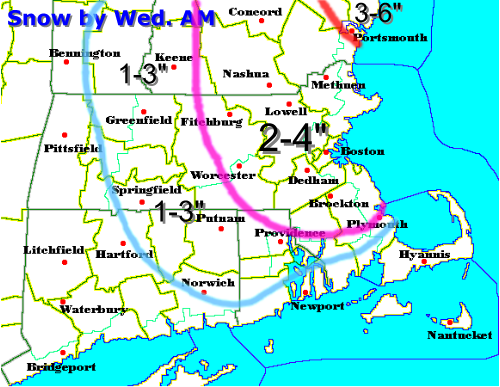
Above is a map of how much water will fall from the sky overnight tonight and tomorrow. As you can see much of eastern Massachusetts and northeastern Rhode Island are in the dark green area, which equates to .25" to .5" of water. That, in a 10:1 ratio equals about 2-5" of snow. For now I am going to go with 2-4" in much of that dark green area above. In northeastern MA, in mostly Essex County and the most eastern portions of MA north of Quincy, may get involved in the band of snow mentioned above spawned by the rare "Norlun Trough." If these spots do get involved in the Norlun Trough snows, they certaintly would receive that 4" and maybe up to 6". However, I am going to be on the safe side and forecast a general 2-4" there. THUNDER SNOW is also possible with this storm so if you see a flash of lightning or a crackle of thunder, don't worry, you aren't hearing things.
Sorry Cape Cod, the Islands, and the South Coast of RI and CT. Can't do anything to muster up lots of snow for you guys. I know many of you commuters are very disappointed about that. NOT! Looks like you will be just too warm, or mild, to support any accumulating snow. You guys will see mostly mixed rain and snow, but when it comes down at its heaviest, the cold air from above may come down to cool all levels of the atmosphere to give you a time of heavy snow. However, generally you guys will see an inch or less of accumulation. Sorry, MOSTLY RAIN showers on the Cape.
Here is how I generally how the snow will accumulate:
That is how the snow looks to come, with a wide area of 2-4" in eastern MA, from Worcester to Boston to Lowell to much of southern New Hampshire. 1-3" can be expected SW of Providence and west of Worcester. Outside of the 1-3" area, there will be an accumulation, but will be more scattered as much of your snow will fall as scattered snow showers and squalls. One town may get nearly 3" and nearby may only get a dusting. Northeast of Portsmouth, that is where the heaviest and most persistant band of snow will set up and a good 3-6" is forecasted there with some spots in southeastern Maine picking up 6" or more.
A SNOW ADVISORY will likely be posted for much of eastern SNE, excluding the Cape and western MA, later this afternoon and I wouldn't be at all surprised to see a WINTER STORM WARNING hoisted for the areas in Maine, near Wells, where the heaviest snow will likely fall.
Tomorrow will be a cloudy and cold day after the snow and Thursday and Friday we will be in the deep freeze with highs generally around 32. Saturday and Sunday will feature moderating temperatures ahead of the next storm, generally in the lower 40's, before clouds increase Sunday night as the next coastal low heads our way.
Right now, I will just say that the Monday forecast looks very interesting with the possibility of a decent Nor'Easter storm with abundant cold air readily available with a strong high in perfect postion in southeast Quebec. Could get even more wintry around here by that time. We'll see...
More on the tonight and tomorrow's snow later!

Monday, January 23, 2006

Snows Aftermath...Bitter Chill and More Storminess

Wow! That was a pretty decent New England snowstorm we just experienced this morning and early afternoon with generally 5-10" just south of the Mass Pike to southern New Hampshire. Here is how some towns in southern New England faired...

Boston, MA: 4.4" (Logan International Airport)
Woburn, MA: 6.5"
Belmont, MA: 8"
Waltham, MA: 8"
Newton, MA: 5"
Cambridge, MA: 5"
West Boylston, MA: 11"
Worcester, MA: 10"
Providence, RI: 2"

The South Shore, including Bridgewater, and areas south of the Mass Pike by 20 miles and just north and west of Plymouth picked up about 4-6" of heavy wet snowfall. Near Plymouth and just off the South Coast there was about 1-2" of gloppy slushy snow.

Down on the Cape there was not much more than some slush as about an inch and a quarter of rain fell, as most of us were experiencing near whiteout conditions between 9-12 noon. Snowfall rates at one point were on the order of 1-2" per/hr. We managed to get most of our snowfall in about 6-8 hours. And this was generally a heavy wet snow that all fell with temperatures at 32-33 degrees and then ended as a period of drizzle and flurries around 2 PM. Most of this will clear away and all the slush will freeze in place overnight as low temperatures will generally range in the mid-upper 20's.

Tomorrow, amazingly will manage to reach into the upper 30's to around 40 throughout most of southern New England and there will be some melting going on.

Tomorrow night we may see a few snow flurries or a passing snow squall depositing a quick dusting to half an inch of snow. Then the somewhat arctic chill will move into the area with highs in the upper 20's to around 30 on Thursday and highs will be in the mid 30's on Friday.

Saturday will probably feature fair skies with temperatures generally a seasonable levels in the mid-upper 30's.

THEN IT GETS INTERESTING AGAIN!!!!!

A storm will be moving up at on Sunday from the Missisissippi Valley and this could be another marginal rain/snow storm and this storm has the potentail to deliver lots of moisture. Right now, areas north and west of Boston and the coast will have the best chance of seeing significant winter precipitation. Rain/snow line will be an issue again.

More on this and the weather for the rest of the work week later!

Sunday, January 22, 2006

Monday Snowfall Accumulation


Graphic Courtesy of Accuweather.com

This graphic is fresh off the presses from Accuweather. As you can see, the 3-6" band is closer to Boston as I advertised earlier. The best bet is the farther north and west you live from Boston, the better chance you have at receiving 3" or more. However, some spots in western MA may pick up close to 7" or 8".

About the "pattern change," it may look like it will have to wait as after the chill on Thursday and Friday, we may rebound back into another January Thaw with highs back well into the 40's. Some places may soar all the way back up into the lower-mid 50's by the time we get to Saturday. Let's just hope this isn't a 4 week thaw as we have just experienced...

More later.

Some Snow Monday


As the graphic above depicts, snow is will be moving into the area early tomorrow morning in southwestern CT and move northeastward to encompass much of southern and central New England. However, with current forecasts from the NWS, this brief period of moderate snow will likely change to sleet and then plain rain south and east of Interstate 95, including Boston, Providence, Plymouth, the Cape, and much of the South Coast.

Why is this going to occur?

Well, currently the ocean water right off the coast is all the way up into the lower 40's. A buoy in Boston Harbor currently reads 41 degrees. This is unusually warm for this time of year. Usually sea surface temperatures should be in the 35-40 degree range at this time of year at the end of January. With the easterly winds we will endure much of the storm, all of this warm air from the Atlantic will overspread the lower and mid levels of the atmosphere, changing any snow over to rain, heavy at times. Further inland, away from the influence of the ocean, anywhere west of I95 or Rt. 128, there will be colder air with temperatures around 33 or 34. This will be a marginal temperature for snow or rain. It could easily go either way. However, along the coast temperatures should rise safely above freezing to around 37 or even 39 degrees. Outside of Rt. 495, there will be some of the coldest air where temperatures will likely stay around 30-32 throughout the storm, making most of this event, a snow event.

Now that you know the temperature story of the storm, how much snow and/or rain is going to fall?

Well, down on the Cape and South Coast, expect possibly a few wet flakes early on, but that will rapidly turn to ALL RAIN and you may pick up one half to three quarters of an inch of rain.

From Plymouth N&W to Providence and Boston and just N&W of Boston by 5-10 miles, expect a brief period of light to moderate snow which will likely accumulate to around an inch, maybe two, but much of it should be washed away as it too will likely change to ALL RAIN by the noon hour and become a light to moderate rain as well.

From NW of 128 to 495 including NW RI, here is the tricky part of the forecast as one degree could make all the difference between mostly snow or snow to rain. This area includes cities such as Lowell, Lawrence, Burlington, Concord, Natick, Framingham, and Acton. Here accumulations should be on the order of one inch if we quickly change to rain, but if we stay more of a snow event as some forecast models are now indicating, we may pull out with 3 or 4 inches of snowfall. This will be VERY close.

N&W of 495 including the cities of Worcester, Fitchburg, Charlton, and Princeton this is where it should be mostly a snow event with high end Advisory type snows likely. A few spots may even see low Warning type snow, 6" or 7", in the highest of elevations. Generally we are talking about 3-6" of snow.

Currently in the Berkshires of MA and the Litchfield Hills of NW CT, there is a Winter Storm Watch. Here they may have temperatures stay in the upper 20's to around 30 throughout the storm and may see the most moisture as the will have upslope winds off of the Berkshire Mountains. This will make the eastern slopes of the Berkshire Mountains pick up the most snow in the snow event. I am currently thinking snow accumulations will be on the order of 7-10".

Again, this looks to be a western New England snow event and eastern New England will just have to wait their turn. It will happen again this winter. I think...

I will post a snowfall accumulation map later in the day as the details of this storm become more certain. Stay tuned, especially if you live in Worcester County and beyond...

Saturday, January 21, 2006

Winter Storm on the Way!

Well, today it looks like this storm will be hitting much of southern and even central New England. Areas from the South Coast to Concord, NH will be feeling the effects on this one. Looks like a pretty good amount of precipitation will be moving into the area with up to 1" of liquid on the South Coast to anywhere around .5" to .75" of liquid north of there to the MA/NH border and about .25" to .4" north of there to central New Hampshire.

Next question is where will this rain/snow line set up shop. Looks like most areas just off the coast by 5-10 miles and north of the Mass Pike will likely see mostly see snowfall out of this one. Also, higher terrain areas of NW Rhode Island and northern CT may see accumulating snowfall. Areas west of Framingham and generally to the NW of Providence will see snowfall as well throughout most of the storm. To the SE of here into the southeastern part of MA including Bridgewater, Brockton, Walpole, southeast and beyond the storm will primarily be a mixture of rain, sleet, and snow with primarily rainfall on the Cape and the Islands as well as the South Coast.

The exact track will eventually play a huge role determining where the rain/snow line will set up through much of the storm. A slight shift to the east would mean that the line will collapse further south and east, but the moisture would not make it as far north and west. A track further north and west would mean more precipitation, but more of it in rain here in much of SNE and central and northern New England would get the lion's share of snowfall.

Where I am thinking the jackpot for this storm will be...

Right now I am thinking that areas as I mentioned above to get mostly snowfall, the potential exists for 3-6" of the white stuff and the highest elevations above 1000' may see higher amounts than this possibly 6-8"+. Yeah, that is the kind of storm we will see. After that Wednesday night ARCTIC AIR will be moving into the area with highs struggling to reach 30. Highs throughout this time period will generally be in the mid-upper 20's! A big difference from the upper 50's to lower 60's of today the 21st.

PATTERN CHANGE!!!

Yup, all snowlovers out there, its looking more and more likely! A change to a colder and snowier pattern is almost upon us and February will most likely be a crazy month with lots and lots of cold and snow.

More on the potential WINTER STORM later!

Friday, January 20, 2006

Trending North???? The $64,000 Question

Just letting the reader(s) out there know that this storm is starting to trend farther north with the latest run from the ETA forecast model. Just throwing it out there. I may have to revise this snowfall map, most likely will, but for now I will pretty much stick with it until I become much more confident and these new runs of the computer models become more consistent and agree with one another. The newest run of the GFS is coming out shortly...

As always...

Stay Tuned..............................

My Current Thinking...


Here is my current thinking as to what may be happening with this late January "storm" this Monday afternoon and night. Currently, local media outlets are forecasting a light mix of rain/sleet/snow, but with each new run of the computer models, this storm just keeps moving further and further south. Some computer models are barely making the light snow and flurries band this far north around Brockton, MA; Putman, RI; and Hartford, CT. Down south on the Cape will see a very light mixture of rain and snow. We are not talking about a whole lot of precipitation here. Maybe a trace to a tenth of an inch of liquid north of the dark gray line and .1" to .2" of liquid to the south on the Cape. In normal situations this would equate to 1-2" of snow, but temperatures at this time will be in the mid to even upper 30's, limiting any accumulation and where it could stick to the north of the dark gray line, where temperatures will be in the lower 30's on Monday afternoon, there just will not be enough precipitation to see any of these flurries amount to anything. So, at this time, very early out, I am calling for NO ACCUMULATION, just some wet pavement on the Cape and South Coast and maybe a skim coating of snow around Providence, RI.

Again, nothing to write home about...

Need Some Snow!

Where I live, just outside of Boston, our last good snow was all the way back on December 9, 2005 when we had the thunder snows and about 14" of the white stuff. Ahh, what a day. Now, it feels like it is in the middle of April and right now just before 11 AM, it is approaching 50 and we may see a high just shy of 60 by one or two degrees.

Tomorrow will feature much of the same, temperaturewise, but it will be much more cloudy with a few passing light rain showers from time to time.

For the snow potential up north in the mountains of Vermont, New Hampshire and Maine, I had to move the rain/snow line a little bit father north to being that anywhere to the north of Burlington, VT and north of Berlin, NH will see wet snow. Also, well to the west of Bangor and Augusta, ME there will be snows in the western mountains in Maine. To break it down, I had to lower my snowfall forecast predictions from yesterday.

Starting time is tomorrow morning for most.

In the most northern Green and White Mountains, and I am basically talking right up against the Canadian border we may see an accumulation of 1-4" with the most obviously in the highest elevations. In northern and western Maine, we may see a bit more with a snowfall accumulation anywhere from 3-5", mostly confined to the highest elevations as well. This will not be a major or even moderate storm. Basically, if this was last winter, this type of snowfall would barely get mentioned, but since its a different year, this is news.

News on the potental wintry mix for early next week. (Monday/Monday Night)

Well, with each new run of the computer models, the trend of this storm is to develop farther south and head more east out to sea, grazing the Cape and South Coast with a few light snow showers or light rain showers. North of the Pike and in Boston, sprinkles and flurries looks like all that we will be able to muster out of this one, sadly. Snowlovers, I really don't know what to tell you, at this point it just doesn't seem like it is our year. Every single time we have a chance of snow the chance of it happening just gets less and less as we approach it. Looks like this Monday's storm will be no exception, barring a miracle in the track of this storm more to the north and west.

Colder air next week?

Well, after Monday we will see highs in the upper 30's Tuesday through next weekend, which ironically enough is still a tad Above Average. Another storm will develop off the North Carolina coast later next week, but all signs are that it is going to push out south of us, maybe grazing the Cape with a little light mix. What a winter, seems like when we get cold enough for snow, we can't buy a storm system, but when a storm system does come toward us, it warms up just in time and we get a mild rainstorm.

Maybe we snowlovers, or powderhounds as blogger Mr. Richard Foot likes to say, will have better luck in February. Our time is running out though. Crocuses are already starting to pup out through the ground and as well as some tulips!!!

We have to change this pattern and fast.

Thursday, January 19, 2006

Skiers Delight

Like the headline says, the upcoming forecast will be a skier's delight. Well, basically northern New England skiers. Looks like a Saturday snowstorm for northern New Hampshire, Vermont, and central and northern Maine. Looks like a fairly significant snowstorm for these regions, especially in the mountains as they will see the heavier snow compared to valley locations.

If you are heading up that way, as I know a few people going up to North Conway skiing this weekend, you are going to know several things; when are we going to see this storm, how much will fall, and where will it fall.

To the first question, we will see this storm move in during the morning hours on Saturday; earliest in Vermont and latest in Maine. With this storm, however, most of the precipitation associated with this storm will be confined to areas north of Concord, NH. The rain/snow line will set up shop right around Conway, NH. Areas to the north of this line will likely see accumulating snow most of the day on Saturday. We are not talking the usual powder we see in mid January, but the gloppy wet March and April type snow. It will stick to everything, including trees and power lines. The snow may be a little less gloppy in the highest of the mountains. So, how much? Areas from Conway, NH northward will generally see a 2-4" snowfall in the valleys to about 6" in the mountains. Areas to the south of Conway will just see a few snowflakes and no accumulation.

This is strictly a north mountains snowstorm, if you even want to call it that.

Later Monday night into Tuesday, more of us here in southern New England may see accumulating snow, but it will be a close call if we even get the precipitation shield this far north, as it may just get to about the NH/MA border and the second question is how much cold air will be in place, causing questions with a rain/snow line. Doesn't look anything more than a minor event at this time, but as you know things here in New England generally tend to change and rapidly with little to no warning.

I will keep you tuned on this weekend's skier's delight and the possiblity of a snowstorm around these parts early next week. Remember what snow is? Its that white stuff that falls from the sky. Its been that kind of winter...


Wednesday, January 18, 2006

Windy Wet and Warm Wednesday

What a day! Winds are very strong out there as of 1:30 pm. Sustained winds are in the 30-40 mph range with gusts up to 65-75 mph throughout southern New England. Last hour, at Blue Hill, they measured a 92 mph gust! What a storm. Just imagine how great of a blizzard this would be if this happened to be in the form of snow.
Rains are moving into the area from west to east and are already in Boston and will continue, heavily, until about 4 pm in Worcester and it will shut off around 5 pm in Boston and 6 pm down on the Cape. As the band of rain is moving rather rapidly we will see most of our rain in a short 3-4 hour period. All said and done, 1-3" will be the general rule for rainfall from this system.
There is a FLOOD WATCH in areas highlighted above where the combonation of melting snow, 3-9" on the ground, and the heavy rain will cause localized flooding and small rivers and streams may spill over their banks. Elsewhere, in eastern Massachusetts, there will be ponding of water on the roads as the heaviest of the rain pushes through. It is raining all the way into ski country. Here a general rainfall of 1-2" is expected and later tonight we may see a changeover to snow showers in the Green and White Mountains with little accumulation in the valleys and maybe an inch or two on the mountain tops.
Temperatures around southern New England today will range from about 55-65! Temperatures will cool off into the 40's by about 7 pm when the cold front moves threw the area, which is currently around Albany, NY. In northern New England, highs will be in the 40's and 50's. Not what skiers and snow lovers like to hear.
Better news to come for us snowlovers? Well, in the short term, NO. Tomorrow and Friday will feature highs in the 40's and 50's and then Saturday, you guessed it, more rain for much of New England again, even for the mountains. It will move into the area Saturday afternoon, BUT with this one much colder air will likely wrap around this one and change any rain into snow and accumulating snow for much of northern New England where a few inches are possible Saturday night. Even here in northern Massachusetts, I would say anywhere north of the Mass Pike by about 25 miles may see a few snow showers, which could add up to a thin coating. I will keep you tuned on this possibility, but by no means will this little storm system be something to write home about. Here in Boston, we probably won't even see much more than a passing flurry as the storm passes away out of the Gulf of Maine and a strong NW drying wind takes its charge.
Sunday we will see a return to colder January weather. Highs staying into the 30's? Its possible and we may even see colder weather for early next week and highs may stay in the 30's for a while. A pattern change? It will happen, we will GRADUALLY transition into a colder and snowier pattern, but it will take time. I would say we will gradually see highs slowly lower next week and we will see chilly conditions before the bottom falls out and all these rainstorms turn into heavy snowstorms. It will happen, in two weeks we could potentially be in a snowy and cold mid winter pattern and the highs in the 60's of today and the past 4 weeks will be an all too distant memory.
Next post later on maybe tomorrrow if the Saturday mini storm still looks to deliver at least a few inches of heavy wet snow to the mountains of Vermont, New Hampshire, and Maine.

Tuesday, January 17, 2006

April in January?!

We are now past the halfway point in January and one thing has come to mind, its January? Well, the coating of snow and the past two nights of lows in the single digits and teens have reminded us that it is still January, but looking at the forecast, you would think we were in the middle of April.
Today will be a fairly average January day with highs in the middle 30's with increasing clouds this afternoon. We may even see a mix of rain, sleet and snow after rush hour and areas well north and west of Boston may actually see a coating to an inch of sleet and snow. Tonight, however, temperatures will rise to the upper 30's to lower 40's and any inland ice should quickly turn to rain, but areas to the north, mainly in the mountains may stay in the form of frozen precipitation until about noon with an accumulation of 1-3".
Tomorrow morning the rain will get heavy and the temperatures will soar into the low-middle 50's with a raging South wind on the order of 25-35 mph, with gusts on the order of 45-55 mph. Scattered power outages are possible. With the heavy rains and deep snow pack in Worcester County and beyond, the National Weather Service has issed a FLOOD WATCH for possible street flooding and basement flooding especially in western MA and southwestern NH where they received 8-12" of snow this past weekend. Finally, we should see about 1" to 1.75" of rain throughout southern New England. At the very end enough cold air may actually make it in to change the rain to a few snow showers in southwestern NH, including Keene, NH. Little or no snow accumulation would occur.
After this mild rainy storm system, we will have a westerly wind with mild temperatures in the low-mid 40's with partly cloudy skies. After that 50's will rule Friday and Saturday and we may have to contend with more rain sometime on Saturday, and it will be in the form of rain, not snow. Snow will be limited to far northern New England near the Canadian border, if that. Also the highest mountain tops above 2500' may see some snow Saturday. Again, it will cool off Sunday into the 40's only to warm up again possibly later next week.
For the snowlovers out there, including myself, it looks like we can't catch a break. Maybe February will bring some relief.