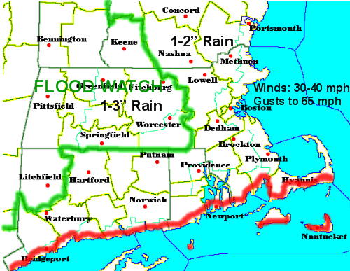
What a day! Winds are very strong out there as of 1:30 pm. Sustained winds are in the 30-40 mph range with gusts up to 65-75 mph throughout southern New England. Last hour, at Blue Hill, they measured a 92 mph gust! What a storm. Just imagine how great of a blizzard this would be if this happened to be in the form of snow.
Rains are moving into the area from west to east and are already in Boston and will continue, heavily, until about 4 pm in Worcester and it will shut off around 5 pm in Boston and 6 pm down on the Cape. As the band of rain is moving rather rapidly we will see most of our rain in a short 3-4 hour period. All said and done, 1-3" will be the general rule for rainfall from this system.
There is a FLOOD WATCH in areas highlighted above where the combonation of melting snow, 3-9" on the ground, and the heavy rain will cause localized flooding and small rivers and streams may spill over their banks. Elsewhere, in eastern Massachusetts, there will be ponding of water on the roads as the heaviest of the rain pushes through. It is raining all the way into ski country. Here a general rainfall of 1-2" is expected and later tonight we may see a changeover to snow showers in the Green and White Mountains with little accumulation in the valleys and maybe an inch or two on the mountain tops.
Temperatures around southern New England today will range from about 55-65! Temperatures will cool off into the 40's by about 7 pm when the cold front moves threw the area, which is currently around Albany, NY. In northern New England, highs will be in the 40's and 50's. Not what skiers and snow lovers like to hear.
Better news to come for us snowlovers? Well, in the short term, NO. Tomorrow and Friday will feature highs in the 40's and 50's and then Saturday, you guessed it, more rain for much of New England again, even for the mountains. It will move into the area Saturday afternoon, BUT with this one much colder air will likely wrap around this one and change any rain into snow and accumulating snow for much of northern New England where a few inches are possible Saturday night. Even here in northern Massachusetts, I would say anywhere north of the Mass Pike by about 25 miles may see a few snow showers, which could add up to a thin coating. I will keep you tuned on this possibility, but by no means will this little storm system be something to write home about. Here in Boston, we probably won't even see much more than a passing flurry as the storm passes away out of the Gulf of Maine and a strong NW drying wind takes its charge.
Sunday we will see a return to colder January weather. Highs staying into the 30's? Its possible and we may even see colder weather for early next week and highs may stay in the 30's for a while. A pattern change? It will happen, we will GRADUALLY transition into a colder and snowier pattern, but it will take time. I would say we will gradually see highs slowly lower next week and we will see chilly conditions before the bottom falls out and all these rainstorms turn into heavy snowstorms. It will happen, in two weeks we could potentially be in a snowy and cold mid winter pattern and the highs in the 60's of today and the past 4 weeks will be an all too distant memory.
Next post later on maybe tomorrrow if the Saturday mini storm still looks to deliver at least a few inches of heavy wet snow to the mountains of Vermont, New Hampshire, and Maine.
No comments:
Post a Comment