Monday, October 30, 2006

Have a Happy WARM Halloween


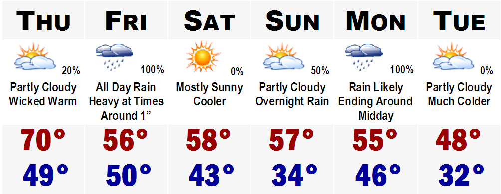
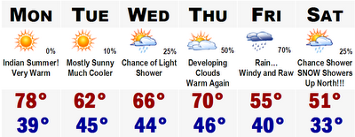
Amazing. I cannot believe it is already that time of the year again. Happy Halloween. I hope everyone has a safe and happy Halloween. Tomorrow will be a great night for trick-or-treating. After having highs around 70 degrees around 2-3PM, temperatures will slowly drop through the night. Here is a time by time breakdown for all you trick-or-treaters and parents.

4:00 PM....Mostly Sunny Mid 60's (Sun setting at 4:38 PM)

5:00 PM...Dry Around 60

7:00 PM....Dry Mid 50's

9:00 PM...Dry Lower to Mid 50's

12:00 MIDNIGHT....Dry Upper 40's

After that, you are on your own.

The warmth will continue into Wednesday the first of November, but then a surge of new cold air will move into the area later this week, especially Friday with highs in the lower to mid 40's throughout the weekend. There is even an outside shot of some SNOW FLURRIES in the air Friday night in the Boston metro area. Right now, I would say the chance of snow Friday night is at best 15-20% right now.

Temperatures will slowly moderate ending off the weekend and heading into early next week. Talk to ya'll later.

Friday, October 27, 2006

Rain Rain Rain

Rain and plenty of it is in the forecast for tomorrow. A good 1-2" is likely throughout SNE with isolated amounts possibly over 3". So tomorrow will be a washout, plain and simple. Sunday and Monday will be seasonably cool with highs in the mid-upper 50's.

Halloween will be great with highs in the middle 60's. Don't get used to it though, by the end of the week, we will be back into the grips of autumn with highs struggling to get out of the 40's.

More later.

Monday, October 23, 2006

Cold Times Ahead...

Colder than usual times are ahead this upcoming week. Tomorrow will be cool with highs in the upper 40's to around 50. The same can be said for Wednesday and with more sunshine on Thursday, highs could rebound back into the low-mid 50's, more seasonable for late October.

As this is going on, a storm system will be moving in on us from the southwest. It should cut to around Pittsburgh, PA, bringing in a shield of rain with snow mixed in on the northernmost edge into the mountains of northern New England. A secondary low will form off of Cape Cod, bringing in cold air into the storm even more and this could yield to accumulating snows for much of northern New England. Still to early to speculate, but some areas, especially elevations higher than 1600' could see in excess of six inches of snowfall.

Southern New Hampshire and Vermont could even see some snow mixed in with the rain Friday night. The Worcester Hills could see a few flakes as well. It all depends on how hard the precipitation falls. If it falls heavily enough, it could bring cold air down from the storm, turning the rain over to snow. Needless to say, it could get interesting around here on Friday. Thereafter, expect chilly conditions and on Sunday, we could see a few passing flurries, even down to the coastal plain with highs in the mid 40's.

More on the forecast later...and on a side note...the tropics are gurgling in the Pacific. Hurricane Paul now has winds of 90 mph and Baja California is currently under a Hurricane Watch and will likely bear the brunt of Hurricane Paul. Tropics in the Atlantic continue to be absolutely quiet.

Wednesday, October 18, 2006

A Warm Thursday


Here is a quick look at the five day...

I'll have a little more indepth post later in the week...but right now I'm loaded with work.

More later.

Tuesday, October 10, 2006

MAJOR SNOWSTORM FOR MICHIGAN'S UP

Here comes the snow. A nice three day snowstorm for many up there in the northern Plains and Great Lakes. It will start with some system snow, the initial burst of about 3-6", perhaps 7" of wet snow in the white shaded area and then there will be some lake effect snow showers in the UP of Michigan. In the blue shaded area above, 6-12" of snow is likely, but new information suggests that this area, especially higher elevations may see up to TWO FEET of the white stuff.

Notice the wide area of 6"+ in Canada. That is very important and will act as a refridgerator and make these cool shots even colder and keep them cold. A cold surge will move into the area later this week as it shows in the 5 day forecast below.

Monday, October 09, 2006

COLD POISED TO INVADE BOSTON & NORTHEAST

Here are the preliminary numbers for the snowstorm this week, tomorrow night into most of Wednesday. The UP of Michigan is already under a Winter Storm Watch at the current time. Many spots here will see substantial accumulations, likely over 6". Some higher elevations, inland, could see upwards of 12-15" of snow, believe it or not. Power outages, lines down, and nearly impossible driving conditions are likely here. Most of Minnesota and Wisconsin will just see a meager amount of 1-3" of wet snow. Snow will likely not stick to the roads, but could stick to the trees and power lines and with most of the trees still with their leaves, there may be a few isolated power outages.

In the gray shaded area, expect to see some snow in the air, but it will likely not stick. Just a sign of things to come. There could be a few snowflakes flying all the way down in Chicago later this week, Wednesday. That storm will funnel in our cold air for late week. There may actually be some snow in the Berkshires and Green Mountains on Friday morning. We are not talking about a snowstorm, but there could be some Snow Showers out there with a possible coating of snow in the high elevations and mountains.


The 80 of today is long gone. Highs will stay in the 60's through Thursday and Friday morning and then with the passage of the cold front associated with the massive midwest snowstorm, temperatures will nosedive Friday afternoon through the 50's and probably hover in the upper 40's all afternoon. Highs in the lower 50's are likely Saturday and Sunday with a HARD KILLING FREEZE likely both nights. No escaping it this time, except if you live in the city of Boston.

Lows Sunday morning will likely be in the 20's throughout much of the suburbs, and up in the cold spot of New England, Berlin, NH, lows could bottom out in the mid teens with great radiational cooling. I'll be in New York this weekend...so I'll be posting for the rest of the week and then probably take the weekend off.

More later.

Sunday, October 08, 2006

UPPER MIDWEST BLIZZARD?!!!

Can you believe it? We are already talking about SNOW!! I bet that headline up above got

your attention. Its true. A major winter storm will be taking shape across the nation's mid section later on this week. It will be developing in the "Four Corners" region of the southwest and head up into Colorado all the while tapping into some really cold arctic air from Canada. Highs on Tuesday and Wednesday from Denver to Goodland, KS to Nebraska, the Dakotas, Minnesota, northern Wisconsin, and the UP of Michigan could be staying in the 30's to around 40. Some spots may actually stay in the upper 20's with heavy snow, International Falls.

Blizzard conditions? Yup, they are possible, especially in NE Minnesota, Duluth, International Falls...winds could gust over 50 mph with rain changing over to snow and heavy at that. Snow accumulations will not be as much as they could be in January because the ground temperatures are still in the 40's and 50's. However, any given spot could be seeing a healthy 3-6" of windswept snow from this system in the Northern Plains. Some of the mountains of Wyoming are already under WINTER STORM WATCHES for snowfall in excess of 8". Some spots could see up to a FOOT! Denver and Goodland, KS will likely see their first snows too...maybe a coating to an inch, maybe even a little bit more. Not bad for early-mid October.

Now the forecast for here. There it is...nothing more to say really. Just really really warm tomorrow, Columbus Day with highs approaching 80!!! Tuesday will cool off and then by Thursday we are back into the 70's with rain from the Blizzard moving in which will be with us on Friday. Right now it looks like Friday will be COLD with rain, but if we get on the southern side of the warm front, we could see more of a showery rain with temperatures around 70. It will be something to watch. Saturday will be cold with highs around 50.

More on the forecast later.

Thursday, October 05, 2006

COLD IS BUILDING IN CANADA

We have had it rather easy so far this fall. Temperatures have been reasonable and many spots still have not hit 32 degrees yet...however, that may change come Saturday morning in some spots.

Cold is building in northern Canada and is deepening, getting colder. Losing the sun angle means that these cold shots of air can move into the lower 48 rather easily now and new computer guidance shows a major invasion of cold Canadian air sometime next week in the northern Plains, possibly going as far down to north Texas with freezing conditions.

Denver snow? Possible. Things look to change dramatically after the Columbus Day "heat" with highs in the 70's. The nation could be transitioning into more of a late fall or early winter pattern as many places in the North could be seeing their first snow of the season. Something to watch, but it will certainly be getting much colder in the weeks ahead, no matter what.

Monday, October 02, 2006

INDIAN SUMMER!!!


Yet again, summer weather is returning to SNE. Highs tomorrow will range from the lower 70's along the east facing coasts of SNE to mid and even upper 70's west of the CT River, especially in southwestern CT. It will only get warmer Wednesday as we will really be feeling INDIAN SUMMER. Highs will be in the upper 70's regionwide and even lower 80's in Boston's immediate suburbs. Places that could see 80+ include, Bedford...Norwood...Taunton...Natick...Framingham...Concord...and Woburn.

That will be shortlived though as a cold front will move through the area on Wednesday night and highs on Thursday will struggle to get into the low 60's after morning lows in the low 40's. Friday will be the coolest day of the next six with highs staying in the 50's all day. Morning lows will likely drop down to frost levels and likely hard freeze levels on Friday morning and Saturday morning with lows ranging from the upper 20's in the coldest "burbs," to around 40-45 in the city of Boston.

The cold will also be shortlived as highs Sunday could be pushing 70 once again.

The ROLLERCOASTER ride continues.