 Can you believe it? We are already talking about SNOW!! I bet that headline up above got
 your attention. Its true. A major winter storm will be taking shape across the nation's mid section later on this week. It will be developing in the "Four Corners" region of the southwest and head up into Colorado all the while tapping into some really cold arctic air from Canada. Highs on Tuesday and Wednesday from Denver to Goodland, KS to Nebraska, the Dakotas, Minnesota, northern Wisconsin, and the UP of Michigan could be staying in the 30's to around 40. Some spots may actually stay in the upper 20's with heavy snow, International Falls.
Blizzard conditions? Yup, they are possible, especially in NE Minnesota, Duluth, International Falls...winds could gust over 50 mph with rain changing over to snow and heavy at that. Snow accumulations will not be as much as they could be in January because the ground temperatures are still in the 40's and 50's. However, any given spot could be seeing a healthy 3-6" of windswept snow from this system in the Northern Plains. Some of the mountains of Wyoming are already under WINTER STORM WATCHES for snowfall in excess of 8". Some spots could see up to a FOOT! Denver and Goodland, KS will likely see their first snows too...maybe a coating to an inch, maybe even a little bit more. Not bad for early-mid October.
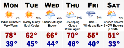
Now the forecast for here. There it is...nothing more to say really. Just really really warm tomorrow, Columbus Day with highs approaching 80!!! Tuesday will cool off and then by Thursday we are back into the 70's with rain from the Blizzard moving in which will be with us on Friday. Right now it looks like Friday will be COLD with rain, but if we get on the southern side of the warm front, we could see more of a showery rain with temperatures around 70. It will be something to watch. Saturday will be cold with highs around 50.
More on the forecast later.
No comments:
Post a Comment