Saturday, September 30, 2006

HELLO OCTOBER!


RAIN tomorrow...all day washout basically. Highs in the 50's. Good day to go to the Red Sox...hopefully thats where I will be. Time to say goodbye to them. Summer will return midweek with highs approaching 80 by Wednesday then on Thursday morning, we will be in the lower 30's. Upper 20's Friday morning.

Goodbye summer.

Thursday, September 28, 2006

Time to Welcome in October


Rain is in the forecast for Friday morning. Rain will move into the area from west to east around 3-4AM west of Worcester to the beginning of the morning commute around Boston and Providence. The rain will be short lived, lasting only 4-6 hours, but will be accompanied with strong gusty winds from the southeast before the front moves through, gusting to around 40mph. Winds could gust over 60mph on the western slopes of the Green Mountains. Winds will shift from the SW after the front, warming us up to around 70 in the afternoon and then shifting to the NW overnight Friday.

Saturday will be cool and Sunday more rain is in the forecast for the late afternoon. The Red Sox could have trouble getting in their last game of the season this year, as rain should start around gametime. Temperatures will struggle to warm into the mid 50's Sunday. Figures, becuause I have tickets to it.

Fall foliage is really starting to come on strong with much of northern Vermont, New Hampshire, and Maine reporting peak conditions THIS WEEKEND! Next weekend, it will be too late for these regions. Expect peak conditions next weekend all the way down to Conway, NH and perhaps just NW of Portland, ME and just north of Concord, NH. It will continue to tumble south during the next four weeks. In four weeks, the color wave will be likely pushing off the south coast of New England and we will be getting ready for winter.

More later.

Side note...T.S. Isaac has formed with winds of 40mph in the central Atlantic and is, you guessed it, going out into the graveyard of the North Atlantic. Maybe some larger surf by the end of the weekend.

Wednesday, September 20, 2006

FROSTY FRIDAY

No 5 day tonight, the link is not working but heres a quick synopsis of the forecast for the next 6.

Frost is likely come Friday morning in much of Southern New England away from the urban heat islands, like Boston, Providence, Worcester, and perhaps Lowell. After not seeing cold mornings in about 2 weeks, it will be a shock to the system when you wake up Friday morning and see that temperatures are in the low 30's.

Highs, however, will rebound to comfortable levels, into the 60's. We will be back into the 70's for the weekend, but the tradeoff will be rain on Sunday, light rain showers. Monday will begin showery, but it will be cooler and Tuesday will be the coolest of the new season as highs look to stay in the upper 50's. Lows could go all the way down to around 30 in the coldest places like Norwood and Bedford, MA.

Other than a little rain Sunday, a pretty good weather pattern continues for the next seven days.

Tuesday, September 19, 2006

Boring Weather Heading into Fall

Well, here we are. We are about to officially say goodbye to summer and welcome in fall. After the past two days in the 80's, that summer weather will be all but a distant memory by the time we reach Thursday.

First of all, RAIN is moving into tonight with anywhere from between a half-inch to one inch of water. This is associated with a frontal boundry and will usher in some cooler air, only managing highs around 70 tomorrow afternoon. Another cool front will move through New England tomorrow night ushering in even colder air for Thursday. Highs Thursday in Boston metro will likely stay in the lower to mid 60's after morning lows in the 40's. Friday morning may be the coolest of all with lows in the 30's widespread in the suburbs and recovering into the 60's. Saturday wil be warmer with highs in the lower 70's as we welcome the beginning of Fall at 12:03AM. Sunday will be a damp day, by the way it looks right now, not a washout at this point, but there will be some showers around.

This will usher in cooler air again and we will be back down into the 60's. Just a side note, expect the OFFICIAL WINTER 2006-2007 FORECAST from "Southern New England Weather" by the end of October. More on that as we approach it.

For now, I'm saying adios.

Friday, September 15, 2006

SEPTEMBER HEAT

Wow, next 3-4 days look to be very nice. Tomorrow after a gloomy start, expect clearing and mostly sunny skies by early afternoon and expect highs to range from the low 70's at the coast to approaching 80 inland. Sunday and Monday will be in the 80's and on Monday could some spots be pushing 90?! Possibly, believe it or not. Thereafter, expect cooler weather Tuesday and COLD temperatures Wednesday and expect the first frost and freeze in most of Boston's suburbs for Thursday morning. Time to harvest the garden this weekend.

Thursday, September 14, 2006

Major Pattern Changes Looming...

No 5 day tonight, but I will tell you one thing, the next week will be a crazy weather week. Tomorrow Friday will be a rather quiet drizzly dank day with highs in the upper 60's with a raw NE wind. Its kind of a dull day all around. I'm sorry to say that Saturday won't be much better. Highs will be approaching 70 late day with some partial breaks of sunshine. Not totally sure of that yet.

Then comes the warm air for Sunday with sunny skies and highs in the upper 70's, approaching 80. You think that is nice, wait until Monday when there will be unlimited sunshine and highs UNBELIEVABLE, MID to perhaps UPPER 80's with a stiff SW wind. That will be short lived though as a major cooldown is expected later next week when temperatures Tuesday will not be quite as warm with scattered showers and perhaps a rumble of thunder. Highs in the 70's.

The cool air will be noticed from Wednesday on. Right now there is a big batch of unseasonably cold air in western and northern Canada and a piece of this will be breaking off into the northern Rockies this weekend, where believe it or not, there are WINTER STORM WATCHES posted for highest elevation areas for snowfall accumulation of 6-12"+! Even the valleys could see a few snow showers and flurries, mixed in with the rain. This pool of cold air will break off from the main area of cold in central and northern Canada and move through the upper Midwest. Major cities like Minneapolis, Des Moines, Green Bay, and perhaps even Chicago could see their first frost and freeze. Lows at this time will be in the 20's and 30's in the northern Plains and Great Lakes. This will be migrating towards BOSTON!

Expect it here Wednesday in a much modified form with highs in the lower to mid 60's with ample sunshine. No snow here. Can be so sure for the mountain peaks, like Mount Washington in NH. A few of the highest peaks may get a quick dusting of snow when this cold airmass moves in. Sorry to say, but my best bet is by this time next week, much of Southern New England's growing season will be all but over or just about to be over as lows later next week will certainly be dipping to around or below the 32 degree isotherm. Only places like the immediate coast and urban heat islands like Boston and Providence may escape frost. You heard it here first.

By the way, there are now signs of "EL NINO" forming in the Pacific Ocean. This has the steriotype of meaning warm and wet for much of the nation, but that is only during a STRONG "El Nino." In a weak to moderate "El Nino" as is forecasted, the East Coast and especially New England can experience harsh snowy winters like we saw in the winter of 2002-2003. If you don't remember, Boston's International Airport received over 72" of snow that season, with the first significant snowfall the day before Thanksgiving.

Just something to watch, stay tuned.

Wednesday, September 13, 2006

Better Days Ahead...

Sorry I have not been able to post for the past couple of days. School has really started full gear this week and promises to be much of the same until winter break, at least. Tonight will be a quick post, but after last night's 32 degree night in Norwood, MA and today's 35 degree low there, there is good news. I don't see that type of cold until a long time from now. Maybe for the next 10 days.

Hurricane Florence hit Bermuda with peak wind gusts there around 100 mph, with minimal damage to property. Now that storm system is quickly becoming extra-tropical over Newfoundland. Now there is Hurricane Gordon, with max winds of 110 mph. It has developed a rather impressive eye. This is something you have got to see on the satellites. TD 8 is by the Cape Verde Islands and is expected to become Helene within the next 24 hours. Very busy, but all look to be staying well out at sea, not affecting anyone, but the fish.

A quick look at the five day and you will see rain will be developing tomorrow, especially after noontime. Rain could come down at a moderate clip tomorrow night and continue off and on through Friday and possibly Saturday morning. Generally, most areas will pick up anywhere between 1-2" of rainfall.

That will clear out late Saturday afternoon and then Mother Nature turns up her heat furnace, something we have had to do the past few nights where I live, anyway. Temperatures by Sunday, Monday, and Tuesday could be in the 80's. This will be our mini-Indian summer for some, Norwood and all of Northern New England as they have already seen their first frosts and freezes. However, the warmth will leave with a few showers Tuesday and by the end of next week, there are signs that everywhere east of the Rockies could be shivering once again. I won't get ahead of myself, but we'll definitely be breaking out the shorts and flip flops for the end of this weekend and early next week here in Boston.

Sunday, September 10, 2006

THE PATS ARE BACK!!!


It is Patriots season once again. Today's game is at 1PM against the Buffalo Bills. Gametime conditions are expected to be great. Kickoff temperatures will be around 68 degrees and by the end of the game, 4-4:30, the temperature is expected to fall into the lower 60's. Should be a great day for the home opener.


The forecast looks very fall-like the next few days with highs in the 60's and lows on Tuesday morning in the 30's, but it will warmup and by next Saturday we should be back into the 70's.

Saturday, September 09, 2006

Cold Early This Week

Summer is starting to whane. Saturday morning in northern Minnesota and Wisconsin temperatures ranged from the lower 20's in International Falls to the 32 degree mark in Duluth, MN and northern Wisconsin. That is an unseasonably early first hard freeze for even them. Saturday mornings low in the Ice Box was a bone chilling 23 degrees this morning.

However, just when they were freezing, literally, SNE is basking in unseasonable warmth. Highs Saturday were in the lower to middle 80's all the way to the beaches. What a beach day! This warmth will not last as a cold front is moving in from the NW and where all the cold air is right now in the northern Great Lakes where there is a whole ton of Frost and Freeze Advisories. This will make our Sunday much cooler with highs likely holding in the mid-upper 60's and probably will fall to the lower 60's by mid-late afternoon. Lows Sunday night and early Monday morning will be in the upper 30's to lower 40's in SNE suburbia and mid-upper 40's in the urban centers. In northern New England, lows will likely be in the 20's and 30's with widespread freeze. Highs Monday will stay in the lower 60's and this cool weather will last at least through Wednesday, and then temperatures will moderate to where they are now with highs by next Friday back to where they were this Friday, near 80.

One thing is for sure, these cold nights upcoming will likely really start the fall colors in a big way. Colors will start to show by next weekend. More on this fall forecast later.

Thursday, September 07, 2006

Warm Next Couple of Days...

Friday will be a very nice day and will feel more like July than early to mid September. Highs on Friday will generally range from the mid-upper 70's on the coast to lower 80's just inland. This will repeat on Saturday and then there will be a few afternoon showers and possibly a thunderstorm, bringing in some fresh cool Canadian air. Sunday will be a cloudy day with lots of clouds and perhap some scattered showers and drizzle. It will not be a total waste of a day as there may be some breaks of sunshine. Highs Sunday will generally be in the middle 60's coolest in Worcester and at the beaches as water temperatures are currently in the 60-64 degree range.

Monday will be the coolest day of the next seven, but it will be mostly sunny. We will just get an October like chill. Highs will be in the lower 60's everywhere and I would not be at all shocked to see the high in Worcester only make it to 59. Monday night will be the coldest night of the season as well as many of the coldest suburbs in the deepest valleys will drop to around 40. Boston, too, may even fall to between 48-52 degrees. After that temperatures will slowly moderate through the 60's and then we may be in the lower 70's to round out the end of next week.

Florence, that will be a storm for the fish and possibly Bermuda. SNE, we don't have to worry except some wind gusts to 30 mph along the coast Tuesday with some large swells and breakers.

Other than that, enjoy this great September weather. This weekend may be the last time we hit 80 again until next spring, so enjoy.

Wednesday, September 06, 2006

Summer Returns?


With the next few days warmth you will think that summer has returned. Tomorrow will be a good day with highs into the 70's. The 70 posted in the 5 day may be 5-10 degrees a little too conservative, especially for inland areas. Highs in the lower 80's will be common on Friday and Saturday before a cold front moves through the second half of the weekend with perhaps some scattered showers. Thereafter, cool air will move into our area and on Monday, Boston will be lucky to get out of the lower 60's for a high.

This cooler air may be our saving grace though. The cold front that sweeps through our area Saturday night will likely just barely sweep what would be Hurricane Florence at this time, out into the North Atlantic only affecting shipping interests and Boston to Bermuda cruises. This will have to be monitored throughout this week, but it is beginning to look more and more likely that Flo will be a no show, at least for Southern New England.

More updates on the forecast and T.S. Florence later.

Monday, September 04, 2006

Back to School for Many...

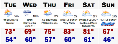
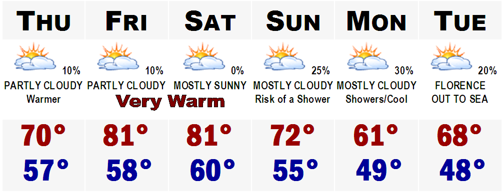
Labor Day weekend is over. It is the "unofficial" start to autumn. It was a pretty good summer weatherwise, but timing of the bad weather was everything. We only had 5 totally dry weekends out of 14. We were right about average with Eleven 90 degree days, the average is 12 for Boston. We also went through 2 heat waves. Plenty of rain, as all of our lawns are still green.

For the Back to school forecast, more rain is on its way. Many schools go back tomorrow the 5th, and they will be greeted with temperatures in the upper 50's at the bus stop. Here is the School Bell Forecast.

BACK TO SCHOOL FORECAST
BUS STOP...Partly Cloudy/Chilly 57
RECESS 10AM...Increasing Cloudiness 66
LUNCH...Partly Sunny 69
LAST BELL...Mostly Cloudy 71
PRACTICES...Overcast 68
Rain will move in after dinnertime tomorrow night and become steadiest overnight Tuesday and into the morning hours of Wednesday. Wednesday will be pretty much a complete washout with about an inch of liquid. Thursday will clear out and temperatures will respond later next week with temperatures into the lower 80's by Friday and Saturday. A major cold front will move through the area later Saturday night and highs on Sunday will likely stay in the 60's with lows dropping into the lower to mid 40's in suburbia.
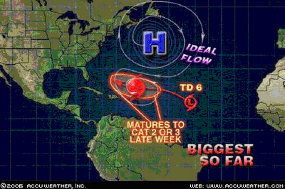
TROPICAL DEPRESSION 6 UPDATE
Tropical Depression 6 is still alive tonight, but hasn't changed much from last night's update. Winds are still at 35 mph. Right now it is encountering lots of sheer from a decaying cold front that moved through our area before. It is just about to move away from that sheer enviornment and once it does it will start to strengthen dramatically. It could become Tropical Storm Florence by tomorrow afternoon. This thing will move slowly towards the eastern seaboard and gather strength all the while. Current projections show this storm reach Category 2 or 3 status by sometime this weekend. It is still a long ways out so all I can say at this time is to keep this potential threat in the back of your mind. This will not become a major story until later this weekend, if it holds together.
More later.

Sunday, September 03, 2006

Waiting for Florence


Tropical Depression number 6 has developed this afternoon. Winds right now are at a maximum 35 mph, nearly T.S. force status. We will have to watch this because the current forecast has this storm cruising into the western Atlantic north of Hispanola as a full fledged Hurricane. A lot can happen in 120 hours, so you will have to stay tuned. More on this developing weather situation when it becomes Florence.

September Is Here!

Can you believe it? September has arrived. Here it is the 3rd of September and it is drizzly and cool. September is usually one of Boston's best weather months of the year. Sometimes sports month too, but this year the Red Sox are so far out of it, let's just hope that they finish the season above .500 at least. After the fairly cool August we had, September is starting out much the same, but there are some big changes in the cards for us in SNE. Tomorrow, Labor Day, will be a perfect last beach day for many looking to do so. Highs will rebound into the mid to upper 70's. Only smear in the forecast would be later Tuesday and Wednesday as rain will be here and it will be a rainstorm much like today's. That will move out of here for Thursday and through the weekend for some warm September weather. Highs Thursday will be through the 70's and on Friday, we could be budging 80 in a lot of spots. Still pretty far out, but Saturday could be the warmest we have seen in nearly 2 weeks, as highs could very well be in the lower to middle 80's!

Something to look forward to because you know scenes like these are right around the corner.

In fact, the Old Farmer's Almanac is calling for a very cold and rather snowy SNE winter around these parts. The cold could be something that we have not seen in several winters. More on my WINTER FORECAST after Halloween.