 Summer is starting to whane. Saturday morning in northern Minnesota and Wisconsin temperatures ranged from the lower 20's in International Falls to the 32 degree mark in Duluth, MN and northern Wisconsin. That is an unseasonably early first hard freeze for even them. Saturday mornings low in the Ice Box was a bone chilling 23 degrees this morning.
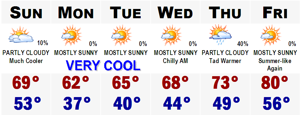
 However, just when they were freezing, literally, SNE is basking in unseasonable warmth. Highs Saturday were in the lower to middle 80's all the way to the beaches. What a beach day! This warmth will not last as a cold front is moving in from the NW and where all the cold air is right now in the northern Great Lakes where there is a whole ton of Frost and Freeze Advisories. This will make our Sunday much cooler with highs likely holding in the mid-upper 60's and probably will fall to the lower 60's by mid-late afternoon. Lows Sunday night and early Monday morning will be in the upper 30's to lower 40's in SNE suburbia and mid-upper 40's in the urban centers. In northern New England, lows will likely be in the 20's and 30's with widespread freeze. Highs Monday will stay in the lower 60's and this cool weather will last at least through Wednesday, and then temperatures will moderate to where they are now with highs by next Friday back to where they were this Friday, near 80.
One thing is for sure, these cold nights upcoming will likely really start the fall colors in a big way. Colors will start to show by next weekend. More on this fall forecast later.
No comments:
Post a Comment