After another cold day tomorrow with highs in the upper 20's to around 30, clouds will increase overnight Wednesday and light snow should break out sometime during the morning on Thursday. I will have more details on this developing storm tomorrow, but here is a quick synopsis.
Time Table: Snow starts around the AM commute from west to east. Snow may mix with or change to rain/sleet south of the Mass Pike during the middle of the storm after noon. North of the Pike, it looks to be a mostly if not all snow event. The snow/mix will taper from west to east; late afternoon in western New England then it should taper to flurries in eastern New England by the PM commute. Great timing, I know.
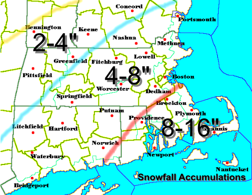
Possible Snowfall Accumulations:
South Coast (including the Cape, southern RI and CT): Coating to 2"
SE MA and much of RI and CT (including Bridgewater, Providence, Hartford, Plymouth): 2-4"
Areas in MA South of the Pike, but not SE MA: (Brookline, Dedham, Sturbridge, Boston): 3-5"
North of the Pike in MA to southern VT and NH (Woburn, Boxford, Lowell, Nashua, Bennington, VT, Fitchburg): Around 6"
North of there, expect amounts to rapidly decrease.
More on this winter weather potential later as the NWS in Taunton will likely be putting out Snow Advisories and Winter Storm Watches later on tonight or tomorrow.
I'll have a visual, snowfall map, for this storm tomorrow afternoon. Stay warm.
Tuesday, February 28, 2006
Sunday, February 26, 2006
Frigid Sunday
Temperatures have remained in the upper teens to lower 20's this afternoon with a mix of sun and clouds. Last night after I posted I looked out the window at about 11PM and it was snowing out pretty good, actually as hard as it came down all day. So, the snow fall totals posted earlier are all wrong. We can easily add 1" to 2.5" to all of the totals below.
Here in Woburn, we finished off with about 3.5" of snow. Rockport, on the North Shore finished off the storm with a healthy 6" and Keene, NH finished off the storm with OVER 10"! I guess the bust call was not as bad as I previously thought.
Anyway, the next few days looks to be very quiet and cold. Next chance of any snow looks to be Monday night, but only a few flurries or light snow. No accumulations are expected. Also, for Thursday, it looks today that the storm is going to be much warmer and weaker from yesterday's runs of the GFS. Looks to be a light event and a snow at the start to a light mix to plain rain situation with any appreciable snows in central and northern New England, but even there it looks to be a very light event. It still is a good four and half days away so things will likely change so stay tuned and watch your local weather reporters and stay tuned to this blog for any further information or a possible snowfall accumulation map.
After Thursday, it looks to get cold again, but not as bad as today and tomorrow. Expect highs around 30 Friday and Saturday.
Sidenote...
Looks like March is going to begin very cold and then by the middle to end of the month it looks like the current pattern we are in will flip, as the NAO will likely trend positive, and storm systems will go west of us and bring in wet, not white, storms with unlimited springlike warmth. For all those people ready to have spring fever, just wait about another 10-15 days you will be able to enjoy the weather again, like you did during "June"uary.
Next post tomorrow or Tuesday.
Saturday, February 25, 2006
A Bust for Many
The Snow Advisory for areas north of the Mass Pike is about to expire at 11PM and the storm is about to end gradually with all snow showers and flurries generally ending after midnight. Well, where I live in Woburn, MA, we only received about an inch and a half of snow. Most of the snow fell in SW NH and far southern Maine where it is still snowing moderate to heavy there at the current time and have seen some snow accumulations approaching eight inches there. Well, here you go, these numbers are pretty much the final accumulations we will see from this storm...we may add on another half inch with some of these totals.
...MASSACHUSETTS......
ESSEX COUNTY...
METHUEN 2"
TOPSFIELD 2"
FRANKLIN COUNTY...
ASHFIELD 3"
EAST CHARLEMONT 2.8"
NORTHFIELD 2.5"
SHELBURNE 2.5"
MIDDLESEX COUNTY...
TOWNSEND 3.1"
GROTON 2.3"
WESTFORD 2.0"
WOBURN 1.5"
WORCESTER COUNTY...
FITCHBURG 2.3"
...NEW HAMPSHIRE......
CHESHIRE COUNTY...
KEENE 8.5"
WEST KEENE 8.3"
HINSDALE 6"
Well, thats about it. All done. Cold weather will hang on as temperatures tomorrow will stay in the 20's and may struggle to reach 20 on Monday with unlimited sunshine. Next storm threat, which could bring snow or a mixed bag arrives Thursday. More on that later.
Friday, February 24, 2006
Quick Hitting Storm

A quick hitting/moving "Alberta Clipper" will be moving in tomorrow morning and early afternoon. Snow will arrive in western New England by 10 AM and then arrive in eastern New England by about Noon. Snow will be light on the onset, but quickly become moderate to heavy as the storm system intensifies rapidly over us. This will enhance the snowfall for most of New England and change the very light snow amounts that Detroit, MI will get and turn those into a moderate snowfall for most. The snow will be heaviest around sunset, as snowfall rates may reach one inch per hour. All snow will be light and fluffy as the ratio of melted liquid to snow will be about 16:1 or 18:1. Generally going for a 3-5" snowfall throughout most of MA, but farther south, a 1-3" snowfall will be the rule. The Cape and the Islands may only see a coating to one inch. Where the ocean may get involved and the most precipitation falls, the North Shore and much of southern NH may see over five inches. A few spots in this area may see six or seven fluffy inches as well. Carry on with your plans as we hardy New Englanders can take this amount of snow in stride. It will be a festive snow that just reminds us that it still is winter.
After this storm departs Sunday morning after a few scattered flurries or snow showers, the cold arctic air will pour in and highs on Sunday will range from the teens north to the low 20's south into Hartford, Providence, Worcester, and Boston. Windchills may be just around zero. Expect the same on Monday with highs in the low-mid 20's and we may even see some more very light snow/snow flurries overnight Monday that will keep overnight temperatures in the teens. Tuesday highs around 30 will be the rule and generally this entire week, highs in the upper 20's to lower 30's will be the rule with another chance of some snow by Thursday.
Enjoy the snow....more later.
Tuesday, February 21, 2006
Snow Chances Popping Up
Since the Blizzard of 2006 more than one week ago, Southern New Englanders have seen a scant amount of snowfall. This past Saturday some of the area received an early morning snow squall that desposited a quick dusting to one inch of snowfall. Most of this occured south and west of the city and towards the South Coast of CT and RI. Also, there was a few snow flurries and snow showers around the area, mainly to the west of Boston, but I did not see any accumulations with this round of snow.
After last week's amazing warmth of temperatures in the 50's and 60's, this week will feature much cooler temperatures near normal of the upper 30's to low 40's through Thursday. Friday may be just a tad cooler with highs generally in the mid 30's. Now to what you have all been waiting for...
The chances of snow I advertised for the area...
First chance of snow will come later Thursday into early Friday. The snow at this point looks to be extremely light and scattered in nature. Generally talking about a few snow showers and flurries. I am not looking for any type of snow accumulations more than a scattered dusting from town to town with this light bout of snow, at this point.
We are getting these quick moving Alberta Clippers, starved of moisture, coming down from Canada and the Great Lakes with the polar jet. The polar jet and the subtropical jet, filled with abundant moisture, look to stay seperated through much of this week and that is why we won't be talking about any large scale East Coast Snowstorms through this period like we saw last week, 8 days ago. To get that kind of storm again, the atmosphere has to realign and the southern stream and the northern stream have to phase just right, off the east coast and move a storm, Nor'easter, up the coast and sock us with snow and strong winds.
However, saying this, some of these "Alberta Clippers" can move off the coast and redevelop a secondary low off the New Jersey coast and rapidly intensify giving much of Southern New England a brief, 6-8 hour, bout of some heavy snows and decent accumulations. However, this kind of storm is hard to predict way out in the future. At this point, there may be a storm that may set up similar to the description above Saturday night into Sunday morning that may give us some accumulating snows. At this point, I, along with all others, am going to play this scenario on the conservative side and just put a chance of light snow in the forecast for Saturday night into Sunday. Right now, I would put the accumulations from this storm in the 1-4" category. Stay tuned though.
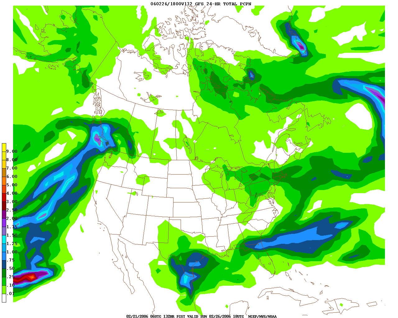
Here is the map for Saturday night through Sunday morning, and as you can see there is some potential for this storm to give us some accumulating snows. As depicted above, most of Southern New England is under the dark green shading, which is about .25" to .5" of RAIN. As this would be snow, that would equate to about 2-5", but at this point, the computer model above, the GFS, is the only reliable computer model showing that much precipitation to fall on our area. Until then, generally keep all plans for Saturday night and don't even expect to use shovels Sunday morning as this looks to be a light dry fluffy snow with light accumulations. A broom looks to be all the snow equiptment we will need this weekend. Beyond that, Monday looks like another even more potent airmass from Alaska will be making its way to New England and highs might struggle to reach the 20 degree mark on Monday and Tuesday before we start to moderate back into the 30's by Wednesday and Thursday.
FOR MY MID ATLANTIC READERS
Special Weather Statements are already up for Washington DC northward encompassing much of Maryland, including the Baltimore metro area, for the Wednesday snow/rain event upcoming this week. Right now, I pretty much agree with their forecasts of light snow very early Wednesday morning and then eventually change to rain showers during the afternoon. However, I believe that the snow will take longer to change to rain in the Baltimore area. However, I believe that it will be extremely light. QPF will generally be around a T-.2", which in a 10:1 ratio would yeild a C-2" of snow. However, with the change to rain and temperatures just marginal to support snow, I would be shocked to see a snowfall amount greater than one inch Wednesday morning in the Mid Atlantic. Until we get a phasing a the two streams, much of the East Coast will be hard pressed to see a sizeable snowstorm. So, do not expect anything to write home about, all snow will be very light and schools will be in session Wednesday as highs may rebound into the low to middle 40's by the afternoon and the snow will definately not accumulate on the streets and highways. Generally expect a coating of snow on the grassy surfaces. Sorry guys, I wish I had better news for all you powderhounds way down there. The Arctic chill will make its presence known by Sunday with highs around 30, and then much of next week will feature highs well below normal in the lower to mid 30's and that may set the stage for some snow. Trust me, there is such a large temperature difference from south to north across the nation and storms love to feed off of this and they generally will form in an enviorment like this, so do not be surprised if a snowstorm does pop up into your forecast. You guys will get another good snow, trust me.
Thats all for now, I will be back sometime soon and have the latest developments on this possible Wednesday morning Baltimore/DC Snow and the chance of light snow around here Saturday night. Enjoy the quiet weather while we have it.
More later.
Wednesday, February 15, 2006
Blizzard of 2006 Pictures
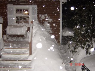
Sorry I am showing these pictures a little late. I just haven't found the time lately. Anyway, this is a picture at the tail end of the storm with about 16" on the ground and most of the shoveling, as you can see was done. This is my front porch.
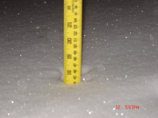
Final snow accumulation, just shy of 17.5" of fluffy snow. By noon on Monday, the next day, the snow had already settled to 13.5".
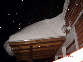
Here is a mighty snow drift of about 30" on a little roof over some of my back steps to the back porch and deck.
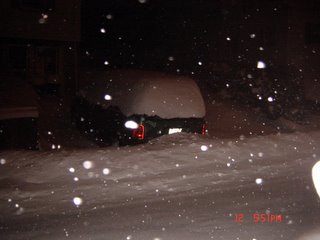
Here is my neighbor's car that was buried by the snow plows. Happy shoveling
If you want to see any more snow pictures just let me know and I'll post some more. Any snow in the forecast. Well, not really, mild air will continue until Friday afternoon and then it is back to the Arctic chill for the weekend and next week. Sunday will only manage the low 20's and Sunday night into Monday morning may be well below zero in many outlying suburbs of Boston and Providence. Enjoy the warmth and melting snow...RAIN FRIDAY THEN BITTER COLD.
Saturday, February 11, 2006
Updated and Upgraded

On this early Saturday morning, all the computer models are going crazy and the NWS has the Boston and Providence areas and south and east under a BLIZZARD WATCH. Everyone else is still under a Winter Storm Watch, with the exception of the south coast of CT, they are under a BLIZZARD WARNING at the current time. Now, why the big change. Simple, the storm is moving more north and to the west than predicted yesterday.
So, there you go. Starts tonight anytime after 7pm, becomes moderate to heavy by midnight, turns to near blizzard conditions by 4am and that will last until about 9am, then snow just turns moderate to heavy for a while and all tapers off by tomorrow evening sometime.
Friday, February 10, 2006
Downplaying for Some, Upgrading for Others
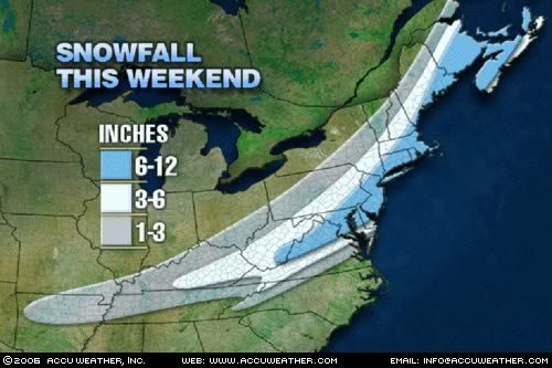 Here is the Accuweather updated snowfall forecast. As you can see much of our area is in the light blue 6-12" range, with 3-6" in much of the southern half of New Hampshire. The NWS has issued a WINTER STORM WATCH for all of southern New England. Currently they are calling for a widespread 8-14" in the entire watch area with 4-8" southeastward towards Plymouth and the Cape, including the islands. However, new information is starting to trend the storm farther south and east taking much of the heaviest of the snows south of the Pike and out to sea.
 This will not be a blockbuster by any means for anybody. Although, it now looks like the Cape and the islands will be seeing heavy snows on the order of 10" or more likely.
Breakdown of the storm...
Starts tomorrow night after sunset. Snow becomes heavy south of the Pike after midnight with near Blizzard conditions on the South Coast and Cape. Light to moderate snows will fall north of the Pike. Coastal flooding should generally be minor with some splashover, but nothing catastrophic by any stretch of the imagination. General tune of this forecast is that I am now downplaying this storm as much of it will harmlessly head out to sea now. Sorry, snowlovers. This storm will still bring some snow, but if you planned on being stranded on Sunday, too bad.
After all that here is what I am currently thinking for snowfall accumulations...
As you can see, I have dramatically lowered the forecasted snowfall accumulations from yesterday and even this morning for areas north and west of Boston. I am still expecting that all counties in Massachusetts will have their Winter Storm Watches upgraded to Winter Storm Warnings. I would not be surprised to see the Winter Storm Watch in Pittsfield County and all in New Hampshire and Vermont to be dropped and eventually downgraded to a Snow Advisory with about a general 2-4" snowfall. Further north and west of there, you will be hard pressed to see a snow flurry. Cape Cod, you will have the jackpot with snowfall accumulations of over one foot likely. A few spots in southeast MA may even see some 15" or 16" amounts.
Finally a city by city trip...
Boston: 6-8" (windswept light fluffy snow)
Hyannis/Cape Cod & Islands: 10-14" (isolated 14"+)
Worcester: 5-7"
Providence: 9-12"
Woburn: 5-8"
Nashua, NH: 3-6"
Western MA: 2-6" (very dependent on the track)
All these snowfall accumulations may need to be raised or lowered all depending on the ultimate track of the storm.
More later and stay tuned!
Thursday, February 09, 2006
Weekend Blizzard Potential Rising
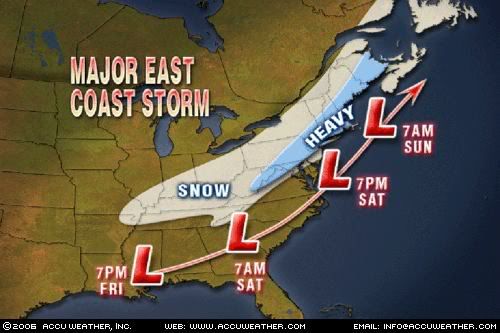
Well, if you have not heard by now, there is a major snowstorm on the way for most of central and southern New England this weekend. Some of the northern mountains may even pick up a decent snowfall from this one. Well, yesterday there was a big shift in the models from an "Out to Sea" storm to a storm that is very likely going to be the defining event of the '05-'06 winter season. Snow accumulations could be very very heavy...likely over a foot in much of southern New England from Hartford to Worcester to Boston.
This is going to be an I-95 Special with heavy snows from the mountains of North Carolina to western Virginia including Washington D.C. This area of moderate to heavy snow accumulations, at least 5", will move northeastward including Philadelphia and much of Pennsylvania, where Philadelphia could be seeing anywhere from 5-10" and interior PA could see 10"+. Northeastward into New Jersey and New York City, a solid heavy snowstorm is on the way for easily 6"+ of wind whipped snowfall. Northwest New Jersey and southeast New York may see even more snowfall than that. Northeast from there is where it will get very interesting where the heaviest snow will fall. Accumulations of 12"+ are starting to look very likely for much of CT, RI, and MA. The only exception to this would be the Cape and the Islands where some rain may get mixed in, especially in the middle of the storm. However, with the newest models coming in, even there, may stay mainly a snow event, allbeit a heavy wet snow event for them.
This is getting very interesting, not only for the potential of crazy snowfall accumulations, but for the fact the winds from the northeast could get very strong, especially near the coastline. Wind gusts of 50 mph or more are very possible. These strong winds could cause minor to moderate coastal flooding along the northeastern facing beaches in much of southern New England.
By the way, if you are in Maine, you will not be out of this storm, as you too will fare the brunt of this storm with snowfall accumulations of easily 6-12" from Portland to Bangor. Western Maine may see a little lighter snowfall accumulations, however.
Stay tuned. This could turn into a dangerous winter storm. Time period to watch will continue to be later Saturday night into the first half of Sunday with strong winds and heavy snows. I will have more detailed and official snowfall accumulations later tonight or tomorrow with a map...I will probably get one off of Accuweather.com and compare it to the one that I will make. Should be very very interesting.
More on this developing winter storm later!
Sunday, February 05, 2006
Winter is Back
Quick Post...
Well, if you have not been outside, you have missed the return of winter. Snow showers were widepread in eastern and central Massachusetts this morning and the snow even came down pretty heavily for a time where I live in Woburn, but hardly stuck. Temperatures today will stay in the mid 30's.
This entire week will feature highs in the lower to middle 30's with lows in the upper 10's to lower 20's. It will be a quiet week of weather with only a chance of some snow flurries Thursday night into early Friday. Nothing big.
This weekend, we could get something a little more important with more than just a snow flurry, but not calling for anything note worthy at this time. Next week looks to be just as cold, but could get a little more stormy around here which will give us more oppurtunities for getting some snow. I'll tune you in as we get closer.
Until then just expect a return to winter temperatures in the 30's and pretty dry and sunny conditions through Friday.
Enjoy, there will be lots of snow making at the ski resorts this week all you skiers and snowboarders.
Friday, February 03, 2006
Is Winter Over?
Seems like everytime I write a post it is during a springlike day in the middle of winter. The big question now is, is winter over? Well, if you have been here for the last SEVEN weeks, you would think that we lived in Atlanta, GA, not Boston. Right now its about 60 degrees out, I am starting to get used to this kind of winter weather.
All the signs of spring are around. About three days ago, there was a robin in my sideyard. Many people here in SNE have also had some of their flowers and crocusses come up. This is about a month and a half premature.
Tomorrow will be another mild one with highs in the lower to mid 40's. Clouds will thicken and lower during the day and by evening rain should be moving in. Just plain rain, all the way up in the North Country as well. The snow will be confined to northern Ohio and southeast Michigan. Cleveland may see over a foot of snow! For Detroit and the Super Bowl, there could be upwards of a half a foot to dig out from.
Next week, after Sunday, colder air will move in, but there does not seem to be many snow chances out there. So, just expect temperatures to be mainly in the lower to mid 30's all of next week with a chance of some snow flurries or snow showers later Thursday with a weak Clipper and maybe some light rain or snow later in the week towards the weekend. Don't hold your breath.
I'll have updates later on the rain for tomorrow night, maybe a half inch to an inch and the colder weather next week.
Subscribe to:
Posts (Atom)