After last week's amazing warmth of temperatures in the 50's and 60's, this week will feature much cooler temperatures near normal of the upper 30's to low 40's through Thursday. Friday may be just a tad cooler with highs generally in the mid 30's. Now to what you have all been waiting for...
The chances of snow I advertised for the area...
First chance of snow will come later Thursday into early Friday. The snow at this point looks to be extremely light and scattered in nature. Generally talking about a few snow showers and flurries. I am not looking for any type of snow accumulations more than a scattered dusting from town to town with this light bout of snow, at this point.
We are getting these quick moving Alberta Clippers, starved of moisture, coming down from Canada and the Great Lakes with the polar jet. The polar jet and the subtropical jet, filled with abundant moisture, look to stay seperated through much of this week and that is why we won't be talking about any large scale East Coast Snowstorms through this period like we saw last week, 8 days ago. To get that kind of storm again, the atmosphere has to realign and the southern stream and the northern stream have to phase just right, off the east coast and move a storm, Nor'easter, up the coast and sock us with snow and strong winds.
However, saying this, some of these "Alberta Clippers" can move off the coast and redevelop a secondary low off the New Jersey coast and rapidly intensify giving much of Southern New England a brief, 6-8 hour, bout of some heavy snows and decent accumulations. However, this kind of storm is hard to predict way out in the future. At this point, there may be a storm that may set up similar to the description above Saturday night into Sunday morning that may give us some accumulating snows. At this point, I, along with all others, am going to play this scenario on the conservative side and just put a chance of light snow in the forecast for Saturday night into Sunday. Right now, I would put the accumulations from this storm in the 1-4" category. Stay tuned though.
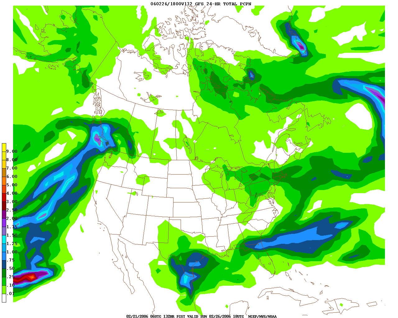
Here is the map for Saturday night through Sunday morning, and as you can see there is some potential for this storm to give us some accumulating snows. As depicted above, most of Southern New England is under the dark green shading, which is about .25" to .5" of RAIN. As this would be snow, that would equate to about 2-5", but at this point, the computer model above, the GFS, is the only reliable computer model showing that much precipitation to fall on our area. Until then, generally keep all plans for Saturday night and don't even expect to use shovels Sunday morning as this looks to be a light dry fluffy snow with light accumulations. A broom looks to be all the snow equiptment we will need this weekend. Beyond that, Monday looks like another even more potent airmass from Alaska will be making its way to New England and highs might struggle to reach the 20 degree mark on Monday and Tuesday before we start to moderate back into the 30's by Wednesday and Thursday.
FOR MY MID ATLANTIC READERS
Special Weather Statements are already up for Washington DC northward encompassing much of Maryland, including the Baltimore metro area, for the Wednesday snow/rain event upcoming this week. Right now, I pretty much agree with their forecasts of light snow very early Wednesday morning and then eventually change to rain showers during the afternoon. However, I believe that the snow will take longer to change to rain in the Baltimore area. However, I believe that it will be extremely light. QPF will generally be around a T-.2", which in a 10:1 ratio would yeild a C-2" of snow. However, with the change to rain and temperatures just marginal to support snow, I would be shocked to see a snowfall amount greater than one inch Wednesday morning in the Mid Atlantic. Until we get a phasing a the two streams, much of the East Coast will be hard pressed to see a sizeable snowstorm. So, do not expect anything to write home about, all snow will be very light and schools will be in session Wednesday as highs may rebound into the low to middle 40's by the afternoon and the snow will definately not accumulate on the streets and highways. Generally expect a coating of snow on the grassy surfaces. Sorry guys, I wish I had better news for all you powderhounds way down there. The Arctic chill will make its presence known by Sunday with highs around 30, and then much of next week will feature highs well below normal in the lower to mid 30's and that may set the stage for some snow. Trust me, there is such a large temperature difference from south to north across the nation and storms love to feed off of this and they generally will form in an enviorment like this, so do not be surprised if a snowstorm does pop up into your forecast. You guys will get another good snow, trust me.
Thats all for now, I will be back sometime soon and have the latest developments on this possible Wednesday morning Baltimore/DC Snow and the chance of light snow around here Saturday night. Enjoy the quiet weather while we have it.
More later.
No comments:
Post a Comment