Friday, November 30, 2007

Winter Storm on the Way!

We have got ourselves an old fashioned New England winter storm on the way to end this weekend. We will expect the snow to develop for all of New England during the afternoon Sunday. It will spread into our area from southwest to northeast and quickly become moderate to heavy, especially north of the Pike. I made this map as a first outlook for what I am expecting for all of New England. I haven't put numbers to these yet, just categorized them. We will start with extreme southern New England, down on the South Coast and Cape. Here we will start as a very brief period of moderate snow that will eventually mix with sleet and then change to rain as temperatures should come up to the mid and upper 30's within a few hours of a ESE wind. There is a possiblility of at least seeing a coating to slushy inch of snowfall in this area. The pink shading is the variable and question mark. Here, if the GFS is correct, we will see more mixing with sleet/rain, but if the NAM is correct, we will only see a brief period of mixing, and a mainly snow event. If I had to put numbers to the pink area, I would say that conservatively 2-4" of snow is likely, including the city of Boston itself. Just N&W of the city, snowfall amounts will increase dramatically. Just 5 miles NW, say in Medford to Newton, we will see a mainly snow event with snowfall amounts in the blue up to southern New Hampshire and southern Vermont ranging from about 6" in Newton to 10-12" in Keene, NH. The blue area for all of New England is where a general 6-12" of snow will fall. More like 5-8" if you want to get more specific inside of Route 495 and especially 128. Then we get into central NH, VT, and ME. This is where temperatures will be in the upper teens throughout the event with heavy snows and gusty winds in excess of 30mph. There is the possiblility of seeing near blizzard conditions at this time. Snowfall, especially in ME, could be very heavy. We could easily see snowfall amounts of 12-24" in the red area. Some places like Sunday River and other ski resorts interior ME could see between 24-36" of snowfall, a dry fluffy snowfall. This is no joke. This will be a major storm that you will need to follow every step of the way until it starts because things are not set in stone just yet.

I will post a more detailed snowfall map with numbers sometime tonight or tomorrow.

Wednesday, November 28, 2007

Thursday Clipper...Ski Country Snows

Ski country will be getting some white gold tomorrow as the clipper system that has been on the maps for several days moves into our area. Don't worry about snow for southern New England. It will be just too warm here in southern New England. Highs tomorrow will rebound to around 45 to 50 degrees in southern New England, while much of northern New England will stay in the 30's. Snow will break out during the day tomorrow from west to east and then could come down moderately in northwestern Maine, with accumulations in the dark blue area of around 2-4", with isolated higher amounts of up to 6" possible. Especially in ski resorts. Other than the 2-4" in NW Maine, much of the rest of northern New England will see a general slushy inch or two of snowfall, with a thin sliver of mixed precipitation. Further south, as mentioned, it will be all rain with mild temperatures before we really cool down on Friday through Sunday. Highs on Friday will be in the mid 30's. Highs on Saturday will be in the upper 20's with the risk of an afternoon flurry and then Sunday will be in the low 30's with snow developing from SW to NE, quickly changing to sleet and then rain from Hartford to Providence to Boston.

It is still way out there, but preliminarily, I would say that areas south of the Pike and along the immediate coast may see a slushy coating on the onset with that quickly being washed away with temperatures rising into the 40's and maybe some 50's on the South Coast on Monday. North of the Pike, generally NW of Rt. 128 and especially Rt. 495, there may be a slushy inch or two of snowfall and snowfall amounts will quickly increase to about 3-6" through southern Vermont and southwest New Hampshire with some parts of northern New England likely seeing over 6" of snowfall Monday.

It's still a wait and see situation, so stay tuned to later changing forecasts. After the storm, very cold weather will pour into New England with highs likely 25 to 35 degrees on Tuesday across the six state region.

Tuesday, November 27, 2007

Back to Cold then Warm then Cold

Our seesaw ride continues. After having highs in the low and middle 60's this morning with the sun shining around sunrise, feeling like a mid July morning, the cold air has ushered back into southern New England. Tomorrow will be a seasonably cold day with highs generally in the low 40's. Then a warm front will move back through the area and we will warm up ahead of a few showers on Thursday with the rain showers being snow showers up in northern New England, mainly Maine, where a couple inches of snowfall can be expected. After the clipper event on Thursday we go back into the deep freeze with temperatures going into the 30's on Friday and then likely stuck in the upper 20's to low 30's on Saturday, despite the abundant sunshine.

Then comes the storm threat for the end of the weekend and Monday. Yesterday and as early as this morning, it looked like we were going to see our first significant snowstorm of the season, but the models have since changed and most it not all of calling for a Lakes Cutter, so that warm air will surge into SNE on a southerly gale and warm us up enough to see plain rain. Ahead of the warm front, we may start as a brief initial period of rain/snow/sleet, but that would quickly transition to rainfall, especially near the coasts. If you want to see all snow, you would have to travel to the far reaches of Northern New England, and even there, a wintry mix cannot be ruled out. Some models go as far as to bring temperatures up into the 50's and 60's again with showery rains into areas of southern New England on Monday, similar to today, especially south of the Mass Pike.

Basically, if you were hoping for a snowstorm to end the weekend, our chances of seeing significant snow are dwindling and FAST!

Sunday, November 25, 2007

Rainy Back to Work Monday

What is better to start off the new work week seeing rain and clouds, to define our depressed feeling of being back at work and school, with no hope of a vacation until late December. Oh well, we needed the rain all summer and we are finally getting it. Tomorrow will be a very rainy day with the rain coming into eastern Southern New England likely after the morning commute. It will become heavy in the afternoon and continue much of the evening and overnight hours, likely ending as showers during the morning commute on Tuesday, after say 8AM. All said and done, we are seeing a beneficial 3/4" to 1.25"of rainfall out of this entire event. Worcester County (northern) is under a Freezing Rain Advisory right now for fear that if this starts early enough tomorrow morning when temperatures are just around 30-32 degrees, there may be some freezing rain. Closer to the coast, by the time the rain moves into our area, the temperatures will have risen out of the freezing range and up to the mid and upper 30's. No threat of frozen precipitation here.

Once it does clear up on early Tuesday we will be talking about a warm afternoon with gradual clearing. Highs will be in the mid 50's and the smell of spring will be upon us once again after leaving on Thanksgiving Day. It will be short-lived, though, with the cold really coming back after seasonable temperatures Wednesday through Friday, mainly in the 40's.

By the start of the weekend, we will be in the low 30's with all eyes turning southwest, looking for our next storm coming with a renewed source of cold air for New England. We will have to wait and see how this eventually pans out for the first of December, with the NAO crashing by this time period. It could get interesting...

Thursday, November 22, 2007

Return to Cold, For a Little While

Today was absolutely amazing. The warmth was amazing. The fog last night and early this moring Pike north was wicked thick and soupy. Once that moved to the north, the sun broke out and the temperatures soared to give us a fantastic Thanksgiving. The Macy's Thanksgiving Day Parade was done this morning with temperatures around 65 degrees! It felt more like a Memorial Day Parade. Temperatures down on the South Shore into Providence were amazingly warm as well. Providence hit a high of 67 degrees with Norwood coming in at 66 degrees. I should have stuck with my forecast from a few days ago. Here where I live, I hit 59 degrees and have since seen the winds shift to North and the temperature has dropped about 10 degrees in the matter of an hour and a half and still falling.

This will usher in the cold and an end to the extreme warmth at least until the next storm system moves in for the early to middle part of next week. First tomorrow will be a much colder and windier day with highs only managing mid to upper 30's. It will feel more like late December, early January out there. Overnight lows will really plummet on Friday night. Low in the suburbs will come down to between 10-15 degrees. The cities will hold onto the warmth a bit longer, with lows coming down to between 25-30 degrees, in Boston. Providence/Hartford will fall to 20-25 degrees.

Then we will start to warm up ahead to the next storm and then we will be talking about a warm windswept rain for Tuesday through the day, likely tapering later in the afternoon with temperatures dropping later. Then we will be back to the cold and wind for Wednesday.

Any snow in the forecast? I don't see it right now. It looks to be dry this weekend when we would have cold enough temperatures to produce snowfall, but once we get some precipitation the temperatures will warm enough for us to see all rain on Monday night into Tuesday.

Thereafter, its too far to know for sure what will happen. These computer models are bad enough going 3-4 days out.

Wednesday, November 21, 2007

Coldest Air of the Season

First, before we get to that we have to get through the raw conditions on the busiest travel day of the year and a very warm and unsettled Thanksgiving Day. Thereafter, we will be able to talk about some cold weather this long holiday weekend and see how our Black Friday forecast will be. One thing I am watching now is that this cold air will not bring a snowstorm to southern New England. It looks that as we head towards our next storm system, we will warm up just in time for this to be a mostly rain situation because all computer models have been consistent in keeping this storm staying west of the Appalachian Mountains. If we get on the southern side of the warm front, we will warm up into the 50's and have showery rains. If not, we will stay with a more steady rain and temperatures in the low-mid 40's in the valleys and northern areas of SNE, while Boston may stay in the upper 40's for highs. This is a week away, so the details about this forecast will be ironed out later.

Tomorrow will be mainly dry for all the football games in the morning for 10AM kickoffs. We should be very mild with temperatures in the 50's at this time. The rain will not move in until later in the afternoon. Once the rain moves in, plummeting temperatures will not be too far behind. By midnight, temperatures will already be falling through the 40's and be in the mid 30's outside of Boston.

THANKSGIVING TIMELINE

8AM Tailgating.......Cloudy & Warm; Around 50

10AM Kickoff..........Cloudy/Chance of Shower; Low 50's

2PM Turkey Dinner............Chance of Shower; Low to Middle 50's

6PM Nap...............Showers Likely; Upper 40's

12AM Late Night Parties.......Showers; Upper 30's

_____________________________________________________________

Finally, I want to wish everyone a Happy Thanksgiving and all get to share it with the people you care about most. I'll have an update on the coldwave coming tomorrow afternoon after the turkey and football.

Tuesday, November 20, 2007

Snowfall Totals from Today

MASSACHUSETTS.

..FRANKLIN COUNTY...

EAST CHARLEMONT 2.3 1050 AM 11/20 SPOTTER
GREENFIELD 2.0 1143 AM 11/20 SPOTTER
SUNDERLAND 1.8 1057 AM 11/20 SPOTTER.

..HAMPSHIRE COUNTY...

GRANBY 1.6 1039 AM 11/20 SPOTTER

...WORCESTER COUNTY...

PAXTON 2.5 1151 AM 11/20 HAM RADIO
___________________________________________________________________

So today was a nice little surprise. The snow quickly moved into the Boston area around 10AM this morning and reduced visibility quite a bit in a few places. In the heat of the snow, the visibility came down to between 1/2 to 1 mile. My unofficial reading for Woburn, MA is 0.5" The snow shut off around 1PM as the main shield of precipitation moved to the SE. The forecast does not hold any more snow for southern New England, but we could be seeing some more rain for Thanksgiving Day. Could be some sloppy football games on Thursday morning.

Monday, November 19, 2007

Tuesday's Rain/Snow

The forecast is looking very chilly for tomorrow. Highs should range from the low to mid 30's North to upper 30's to low 40's South, warmest down on the Cape and Islands. Precipitation will take all morning to reach eastern southern New England. We will finally see the precipitation move in after the lunch hour and it may at first be mixed with a few wet snowflakes here in the dashed areas, this includes the cities such as Hartford-Worcester-Boston-Lowell-Portsmouth, NH-coastal Maine. Areas southeast of here will just be too warm for any frozen precipitation. In the light pink area, we will see up to one inch of snow/sleet/ice. Most will fall early and likely change to drizzle as the precipitation winds down. Where it stays mostly wet snow with highs struggling to get above 32 degrees, up near Berlin, NH and the western mountains of Maine, there could be as much as 1-3" of snowfall. This isn't a big event, but if you get a coating of snowfall, it could mess up your drives.

There is a WINTER WEATHER ADVISORY for the Berkshires and southern Vermont, for some accumulating snow and light ice accretion.

Here is what the NWS out of Taunton is thinking about tomorrow.

TUESDAY... CLOUD COVER AND PRECIP WILL BE MOVING IN EARLY DUE TO LOWPRESSURE SYSTEM TO THE WEST... HIGH TEMPS GIVEN BY MOS WILL BEREDUCED TO ACCOUNT FOR THIS. SURFACE WINDS WILL SHIFT TO BECOMELIGHT AND SOUTHERLY AS THE CLOUDS ROLL IN.PRECIP...A BURST OF WARM ADVECTION WILL TRIGGER A FEW HOURS OFSTEADY PRECIPITATION ACROSS INTERIOR SOUTHERN NEW ENGLAND. IT COULDCOME DOWN AT A DECENT CLIP FOR AN HOUR OR TWO...WITH THE PEAK TIMESBETWEEN 6 AM AND NOON. IT PROBABLY WILL BEGIN AS A PERIOD OF SNOWACROSS INTERIOR SOUTHERN NEW ENGLAND. WE FEEL THIS WAY AFTERLOOKING AT THE UKMET/GFS/ECMWF 2 METER TEMPERATURE AND SOUNDINGPROFILES TUESDAY MORNING. THE NAM APPEARS TO SLOW WHICH IS ATYPICAL BIAS OF THE MODEL AND THINK PRECIPITATION WILL ARRIVEBETWEEN 5 AND 7 AM ACROSS WESTERN MA AND SOUTHWEST NH. THIS MEANSTHAT IT SHOULD BE COLD ENOUGH FOR A PERIOD OF SNOW.

WITH SURFACE TEMPERATURES BELOW FREEZING AT THE TIME PRECIPITATIONMOVES IN...WE COULD SEE AN INCH OR TWO OF SNOW ACCUMULATION ACROSSINTERIOR SOUTHERN NEW ENGLAND. ESPECIALLY IN THE NW INTERIOR REGIONS ANDTHE WORCESTER HILLS, WHERE ITS NOT OUT OF THE QUESTION FOR AN AMOUNTOR TWO EXCEEDING 2 INCHES OF SNOW ACCUMULATION.

THERE IS ALSO ACHANCE OF SOME FREEZING DRIZZLE OR SLEET MIXED IN ACROSS THEINTERIOR. AT THIS TIME...WE WILL NOT HOIST A WINTER WEATHERADVISORY...BUT NEXT SHIFT WILL HAVE TO MONITOR THIS POTENTIALESPECIALLY IF IT APPEARS THAT MORE FREEZING DRIZZLE WILL MIX IN FORA TIME AND THIS WILL BE THE FIRST WINTRY EVENT FOR THE SEASONIMPACTING THE MORNING RUSH HOUR. AGAIN...WE DO THINK THATACCUMULATIONS WILL OCCUR ON ROADWAYS BECAUSE SURFACE TEMPERATURES ATDAYBREAK ARE EXPECTED TO BE BELOW FREEZING.
___________________________________________________________________

We will see what the weather brings tomorrow.

Soggy Turkey Day

Thanksgiving Day is only a couple days away. The forecast is becoming more and more clear as we head towards the big holiday of football and turkey. First lets get through our short work week. This afternoon, there is a band of ocean effect showers that show up on the radar as rain showers down on the South Shore near Plymouth, but I wouldn't be surprised to hear of a few snowflakes mixed in as well. This morning there was a flurry in the Boston area with a few flakes seen around 8:30AM this morning. Tomorrow will start off dry but then the clouds will lower and a period of showers will commence. If the shield of precipitation gets in here before noon, we could be talking about a mix of rain and snow, changing to rain. Tomorrow will be another chilly one with highs in the upper 30's in Worcester County to low 40's elsewhere.

The warmth returns on Wednesday with highs in the mid 50's. Rain showers will likely develop in the nighttime hours. Right now there is a spread at how strong the Thanksgiving storm will be and its exact position, but all models are hinting at an Appalachian runner with southern New England in the warm sector, with highs in the mid 50's with showery rains, becoming heavier later in the afternoon. The GFS is the strongest with an actual strong storm developing along the front, while the NAM is just a front moving through our area. Either way, far reaches of northern New England may see some accumulating snow out of this as they will be removed from the warm sector much of the time.

That will move through and the New England area will cool off into chilly, but not exceptionally chilly conditions. Highs will be in the 40's on Friday through Sunday with moderating temperatures by Sunday. The next storm system will be a warm one coming up from the Southeast. The NAO will be soaring well into the positive range at this time, so we can assume the storm will remain far inland, sending warm moist air into the East.

The forecast of the NAO is for it to turn more negative by the first of December, so we could see a colder, stormier start of the first month of winter. We will see if that comes to be, as it seems like we are always 5-10 days away from that big storm or bigtime cold airmass, only to have the models change 3 -4 days before the event. It's a wait and see kind of forecast.

Saturday, November 17, 2007

FINAL CALL

Forget about that map from today. The GFS tanked again and the NAM was the winner overall. Most models have gone to a dry scenario. Don't expect much more that a few sprinkles of rain or 'snizzle' down on the South Coast and Cape later tomorrow.

Thats it. North of Hartford to Providence to Plymouth, MA, there will not be anything. Not even a flurry. We will mark this up as DISAPPOINTMENT NUMBER ONE for the winter season of 2007-2008.

It will be cold on Monday, however. Highs will stay in the 30's. We warmup thereafter. Did anyone say 60 degrees for Thanksgiving?

CLIPPER: First Call

This clipper system has been on and off for the past week. Early in the week, it looked like we would be getting something from this. Then the signal died. It died to the point where it was barely on the maps anymore. Now the GFS is back on the bandwagon and giving parts of southern New England heavy duty precipitation. However, the NAM, another reliable model is very dry. So if we break it down between the two most reliable models....

The GFS brings the 0.25"-0.50" of liquid to southern Vermont and New Hampshire. This would be mainly snow, so you can imagine that someone or many would see a general 3-5" snowstorm out of this, with rain along the Cape and immediate coastline, Boston being right on the line between rain and snow. It paints QPF up to 1"+ in parts of Connecticutt, so we could see 4"+ there. However the NAM barely brings any rain/snow light showers onto the South Coast with most of the precipitation missing SNE by 100-200 miles. Most of the precipitation would fall over PA and NJ. New York City could see its first flakes.

You can see that the models are AWFUL this season. They cannot even come into some kind of agreement only 24-36 hours before the event. This is a shot in the dark forecast for any meteorologist. If they side with one, they could bust badly, and even if they go in the middle, like me, they could still bust badly. If you call for a the first flakes, even if its a few flurries and it doesn't happen...its a bust. If you call for a few flurries and you get 5" of snow...its a mega BUST.

Basically, this forecast has BUST all over it. I know I will have to change this forecast, but this map is what my first call is. The South Coast will see a mix of rain and snow, mainly rain. Up to .25-.50" of QPF. Further north, where it will be colder, a sloppy 1-2" of snow will fall, highest in the highest elevations in NW Rhode Island and northeastern Connecticutt. Southern Worcester county could see a whitening of the ground as well. Then north of the Pike, expect flurries all the way to southern New Hampshire.

Thats my call for now. If we see the NAM come further north, these snowfall amounts will come up. If they side more with the NAM, don't expect much tomorrow. Timing on all this is delayed now. Mainly late Sunday afternoon through the overnight hours of Sunday. A delay of about 24 hours.

Friday, November 16, 2007

Dry Pattern Sets Up for SNE

After yesterday and this morning's heavy rains, cold rains this morning across southern New England with temperatures in the mid to upper 30's, just to warm for snowfall. It was a wet and windy ride to work early this morning, I, myself, got soaked heading into work this morning as I didn't have an umbrella or raincoat on. Not a smart move. Did you notice the difference a day makes? Yesterday the temperature hit 70 degrees in SE Mass. Today, temperatures have stayed in the 40's with windchills in the 30's this afternoon. Tomorrow will be much of the same and then we step down a couple degrees each day until we bottom out on Monday with highs rebounding only into the mid and upper 30's after morning lows in the mid 10's in the suburbs to mid 20's in the cities.

Thereafter, we will warm up BIG TIME heading into the Thanksgiving holiday. High temperatures on Wednesday will get into the 50's once again and then we could have a really mild Thanksgiving Day with highs in the mid 60's, believe it or not! We will warm dramatically ahead of a cold front loaded with rainfall and ripples of low pressure along the front that will douse the area with heavy rains late Thanksgiving night and early Black Friday. Expect it to feel more like Christmas after Thanksgiving as the coldest shot of air we have seen in a while for November will move into the area for Thanksgiving weekend, later in the period.

Current projections show that the upper Plains, MN, ND, SD, MT, could see temperatures only manage 0's and 10's for highs the week after Thanksgiving weekend with subzero lows. That cold will move east.

Thursday, November 15, 2007

Blustery Friday to Wintertime Cold

We have ourselves a blustery Friday on the way. How was today, though? The temperature hit 70 degrees at about 10AM this morning in Taunton, MA for about fifteen minutes. Then the rain moved in around 3PM in eastern Massachusetts and fell heavily for about three hours, causing ponding in the streets and fender benders all around town this afternoon. It was a mess. A second batch of rain is moving up from the Atlantic as we speak and this will be over our area as the temperatures continue to drop through the night, into the 30's for eastern southern New England. As that happens, any raindrops will turn over to snowflakes for the morning drive, but there will not be any accumulation of the sort. Just decorative snow to go with that Christmas music for the car ride into work. That will all wrap up early in the morning, any time before 9-10AM and then it won't be all that cold, mid-40's, but it will be windy, with windchills in the mid-upper 30's all day. It will have that damp-cold feeling all day.

Wintertime cold moves in after a front passes through on Saturday night and we will only see highs in the middle 30's on Sunday afternoon! The clipper system looks to continue heading to our south as even now the GFS has backed away from its once promising snowfall forecast from yesterday. That said, there may be a few snow flurries or sprinkle south of the Mass Pike early Sunday morning, but that would be about it. Nothing even remotely significant. A nonevent. Waking up Monday morning will be tough with widespread lows in the 10's in southern New England will lows in the single digits up North.

However, the NAO eases and heads back POSITIVE later next week and that will allow the warmth to move over the northeast once again, with temperatures getting back to 60 degrees by midweek and that would be Thanksgiving. Right now, I think the Thanksgiving holiday looks great with partly cloudy skies and temperatures in the low 50's for the 10AM games. Its way out there, but at least there won't be weather on that day for the games, at least thats how it looks now. These models can flip on a moment's notice. So, stay tuned, as usual.

So get ready for the possibility of our first flakes tomorrow morning and get ready for a really chilly weekend.

Wednesday, November 14, 2007

Balmy Thursday

There is one last balmy day in store for southern New England. Tomorrow morning will start off very mild, in the 50's, with a gusty southerly wind, up to 20-30 mph. The wall of water will only be into Springfield, but it will gradually head its way down the Pike and be in Boston before noontime. The rain will be heavy from noon until about 8PM. All said and done, we will see between one-half and one inch of rainfall. A few places will see up to an inch or more of rainfall. The rain will taper during the overnight hours, where in northern New England we will have the rain change over to snowfall where there is currently a Winter Storm Watch for 7"+ of snow in northern Vermont and northwestern Maine, mainly elevations above 2800'. Early Friday morning there may be a few stray flurries all the way down into the Boston metro area, but that would be just about it.

The snow will fly much of the day in northwestern Maine, where some mountain resorts could come in with close to 10" of snowfall, heavy wet snowfall at that. Then we all have a blustery cold Friday with highs in the low 40's. The weekend looks to be mostly dry with highs on either side of 40 degrees.

There is a small chance that we could see some snow with a clipper on Sunday, but most computer models are taking this clipper further south and the only model showing any snow for southern New England is the GFS and it has een awful as of late, so I am not going with its forecast, just yet.

Check in tomorrow.

Tuesday, November 13, 2007

Thursday Soaker

We have one heck of a soaker coming for Thursday, all day. The rain will likely start early in the day and stay moderate to heavy throughout the day as a frontal system moves slowly through the area. A quick shot of 1-2" of rainfall is likely throughout all of New England, through Thursday afternoon. Then all eyes shift south to just off the Delaware and New Jersey coasts. A little area of low pressure will try to get its act together on the front and surge an area of precipitation into all of New England starting later Thursday into the evening and overnight hours. How much precipitation we get is still in question and how cold it will be will determine if we see our first flakes for the 2007-2008 season. 12z GFS was a little more ominous with its snow signal for southern New England compared to the 18z GFS, but we will see. NAM is showing backlash snows for southern New England, so it cannot be discounted, I just have hard times in seeing snowfall after heavy rains here in southern New England. In the Boston area, we rarely go from a balmy rain to a snowfall, not even accumulating snowfall. Its possible, but not likely in the Boston to Hartford areas.

More likely, parts of Maine will see more snowfall. Good for the ski areas, at least. I'll keep you updated.

Monday, November 12, 2007

Warmer Times...at least for a little while

That blob of seasonably cool air is quickly retreating this Monday morning. Its still pretty chilly out there with nearly 11AM temperatures in the mid 30's under overcast skies, smelling of snow. There were a few flurries in southern New Hampshire this morning, but most moved offshore, leaving Massachusetts unaffected by them. That warm front will move through all of southern New England later tonight and stall right in central Maine, leaving the northern part of the state in the cold air, so they will see 1-3" of snowfall tonight, while most of us deal with a few showers overnight, quickly ending before sunrise, even down on the Cape and Islands. Tomorrow afternoon the skies will clear and that southwest, west wind will really start to warm us into the mid and upper 50's. I would not be surprised if someone in southwest Connecticutt came a little over 60 degrees. The same can be said for Wednesday, upper 50's, smelling of spring, but that will all come to an end on Thursday morning with some windswept showers, switching to snow showers over parts of northern New England, ushering in some very cold air for Friday, with high temperatures likely in the low 30's North; low 40's South.

Merry Christmas, oh sorry, the radio switched to Christmas tunes this morning on 103.3 and 105.7.........only about 40 shopping days left.

Sunday, November 11, 2007

Indian Summer?

I don't know if you can call what we will have here in southern New England indian summer, but it will feel very balmy to say the least after the cold we have endured the past few days. Tomorrow will be the last chilly day with highs right on either side of 50, after morning lows in the mid 20's away from the cities. Then we will get into nice warm weather for Tuesday and Wednesday when high temperatures should be getting to around 60 degrees. Then rain moves in for Thursday with a frontal system with a low pressure system getting attached to it and will enhance the rainfall. It will usher in some colder air for next weekend. At the very end of it, the rain may flip to snow in parts of northern New England with an accumulation there possible, especially over the northwestern parts of Maine. We'll see.

Thursday, November 08, 2007

Just Wide Right

That pesky clipper Saturday will be bugging meteorologists across the northeast until Saturday evening when it is long past New England. I am still going for a miss of New England. There will be a batch of rain/snow showers going through Pennsylvania and New Jersey tomorrow afternoon with no accumulation, different from yesterday, and that will slide harmlessly out to sea and become apart of a bigger ocean storm. This storm will rapidly gain steam and become an ocean monster. It will be just SE of the 40/70 Benchmark, as close as it can be without affecting New England in a major way with heavy rain/snow and winds and waves. That said, there could be scattered showers down on the Cape and if a few of these showers makes it north of the Pike and especially to elevations above 500 feet, there will be a few scattered snow showers, that could give a sugar dusting. Again, this storm will JUST be missing southern New England, but it will be a miss nonetheless. Skies will clear Saturday night and we will have moderating temperatures into next week with highs approaching 60 degrees with rain by midweek. We'll see. Guidance out that far is all over the place right now.

Stay tuned for updates on the storm track. Updates from the computer models always come out just before 12AM, 6AM, 12PM, and 6PM, daily. Expect big updates every 5-6 hours. Any slight shift NW, will mark a major change in our weekend forecast.

Wednesday, November 07, 2007

Snows from Clipper

I know that the swath of snow with this clipper looks ominous, but I highlighted the areas in light blue that have a chance of seeing at least a half inch of snow. Most places in the light blue will generally see a coating to one inch of sloppy snow. Where the darker blue is, is where we will see snowfall totals closer to the 3" mark. These areas will be confined to the UP of Michigan and northeast Pennsylvania, where the 00z NAM is absolutely clobbering with up to 0.75" accumulated QPF. It will be cold enough for most of this to be snow, with temperatures in the mid 30's to start, but falling into the upper 20's during the night in northeast PA. Scranton, PA may wind up with 3-4" of snowfall, believe it or not. I have most of the state of New Jersey and even New York City in the light blue. Accumulation in NYC and near the Jersey shore will be little or none. There will be flakes falling from the sky, however, Friday night in most of New Jersey and in Times Square. All of this will snake southwest of most of southern New England, leaving us high and dry. The ocean storm will miss us and the snow from this 'Norlun' type trough will miss us as well. Stay tuned though.

Nice November Cooldown

We are about to embark on a nice November cooldown. The next 4-5 days will be below average in temperatures, mainly in the 40's, but the most important thing will be that it will be dry. We had that weekend storm threat, but it has been off the maps for the past 2 days so it looks like it is finally out of our forecast. It may throw an ocean effect sprinkle down on the Cape or South Shore Saturday afternoon, but that would be just about it. We will really be cold though. Morning temperatures tomorrow will be ranging from the upper 10's in the coldest suburbs to around 30 in the city of Boston. We have our coldest moring on Friday with more 10's and 20's and if Boston doesn't get a freeze tonight, they will Friday morning. The miss is on Saturday and then we slowly start to warm up to a few degrees above normal by Tuesday of next week, ahead of the next storm system. Next week's forecast is of low confidence because there will be wavy fronts all over the place and the eventual storm track of a major storm will dictate our weather, whether we turn white or damp.

Tuesday, November 06, 2007

Weekend Storm is a No Go...

The once promising weekend storm that looked to deliver our first snowfall has fallen through the cracks today. All models have taken the GFS route and have totally taken this storm way out to sea and barely has it develop out at sea. Its a no go. Also, the cold shot behind today's rain does not look as severe as it did a few days ago. It has really moderated to near seasonable levels, only slightly below normal highs on Thursday through Saturday, but next week, the jet will flatten to allow some mild Pacific marine air into the lower 48 and we will all see moderating temperatures. By Monday of next week, we could be seeing highs in the low 60's as a storm system will be starting to cut through the Lakes, which will push in the SW gales and warm gales at that. There are signs that a storm will try to split with one that goes through the Great Lakes while the other one stays back an allows to first to deliver some cold air to the northern States, towards the middle of next week, allowing the southern piece of the storm to develop in the TV and head NE towards the northeast with a swath of moderate to heavy snow somewhere from Chicago to northern NJ and New England. If Chicago gets a snowstorm, we will stay on the warm side and see a showery week with abnormally high temperatures in the 60's. We'll see how that works. Its a long way out.

Enjoy our tranquil week, weatherwise, this week. The NAO is tanking later next week, so the storminess will return after todays heavy rains.

Monday, November 05, 2007

Computer Models on Weekend Storm

This first computer model is from the 12z EURO model. As you can see, it does dip that trough enough to develop a fairly good storm, but the progressive flow keeps that storm system moving offshore as it strengthens. This image is for sometime around midday Saturday, the 10th of November. Without the precipitation forecast, I would expect little to nothing in the way of precipiation with this model outcome, but there may be enough to throw a few sprinkles and flurries in towards southern New England, especially south of the Massachusetts Turnpike, I-90.
The EURO's 12z is an in between the more aggressive GGEM (Canadian) and the meager solution on the GFS, the American model. The GFS keeps a very progressive NW flow as the clipper moves along as a dry area of low pressure mainly with lake effect rain/snow showers. The GFS does develop a storm, but it develops it way out to sea and not even a real threat to boaters near the coast. The next grid of computer model will be the GGEM. This is the one going gangbusters with a big dip in the jetstream as a low pressure will get cranking right around Nantucket, bringing in NE gales to the coast. It would be a quick mover, but would deliver a good thumping of heavy wet snow over the interior of southern New England and even light to moderate snow over Central New England and Maine, bombing out the storm as it heads towards Nova Scotia.

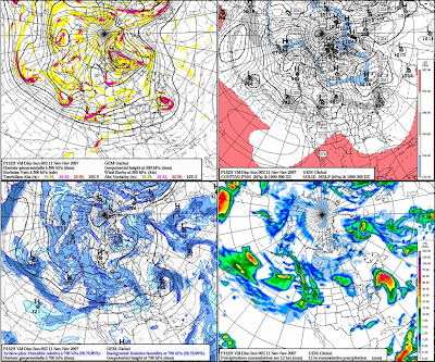
The GGEM is much more aggressive with the deep trough developing, making a huge ocean storm, alla the Nor'easter solution. I am not sure if this will pan out because it is the extreme, delivering a massive early season snowstorm to parts of southern New England. That said, I am not quite yet buying the GFS solution for it is basically not picking up the storm on its OP run yet, but it is showing an amplification along the East Coast that could support cyclogenesis development. Its just not showing anything at this point, both the 12z and 18z OP runs, but this mornings 06z OP run was looking more like the GGEM OP run.
Of note, around this period, the NAO is to go from positive towards negative and likely being nuetral around November 11th or so. When the NAO goes from positive to negative or negative to positive, through neutral, that is when we usually get our biggest storms. This is just something interesting to note.
Right now, I wouldn't rule anything out for this weekend. We know how all the models were taking Noel out to sea for much of the week until about two days before the event, so we will see if it doesn't just do the same with this one as well for this weekend.

Another Nor'easter

Another Nor'easter could be in the works for later this week and weekend. The computer models are continuing to show this storm system with marginal temperatures between rain/snow. Its going to be a real close call. First of all, we have a rainy Tuesday coming with a bout of some heavy rainfall associated with the frontal system. All said and done, much of southern New England will see between one half and one inch of rainfall out of this storm system. This will usher in some much colder air later in the week with highs in the 40's for the rest of the week with highs likely in the upper 30's on Friday ahead of a storm sytem coming out of the Great Lakes and redeveloping along the coast and ever so slowly moving up to Nantucket with a band of precipitation making it all the way into southern Vermont and central New Hampshire. This could last into Saturday with a tossup between rain and snow. Generally, the further away you get from Boston, the better chance you will have at seeing some snow.

Here is what the Boston Forecast Discussion is saying about this event...

HIGH PRESSURE WILL SLIDE OFFSHORE ON FRIDAY AS A FAIRLY POTENT UPPERLEVEL TROUGH APPROACHES FROM THE WEST. THE 00Z GLOBAL MODELS HAVECOME INTO BETTER AGREEMENT WITH EACH OTHER REGARDING THE EVOLUTIONOF THE APPROACHING SYSTEM. ALL OF THEM /EXCEPT THE ECMWF/ NOWDEVELOP A COASTAL LOW OFF THE MID ATLANTIC COAST SOMETIME FRIDAYNIGHT...THEN MOVE IT NORTHEAST WELL TO THE SOUTHEAST OF NANTUCKETSOMETIME SAT OR SAT NIGHT. THE 00Z OP GFS...00Z GFSENSEMBLE...UKMET...GGEM ARE IN DECENT AGREEMENT WITH THIS.WILL

THEREFORE INTRODUCE LOW CHANCE POPS ACROSS THE SOUTHERN HALF OFTHE CWA FRIDAY NIGHT INTO SATURDAY NIGHT. WILL HAVE TO WAIT FOR THEECMWF TO COME INTO BETTER AGREEMENT BEFORE HAVING ANYTHING MORE THANLOW CONFIDENCE. HOWEVER...IF THE 00Z MODEL CONSENSUS PANSOUT...PORTIONS OF SOUTHERN NEW ENGLAND COULD SEE THEIR FIRST MEASURABLE SNOWFALL OF THE SEASON /ALBEIT QUITE LIGHT/. THE COASTALPLAIN LIKELY STAYS LIQUID AS BOUNDARY LAYER TEMPS WILL BERELATIVELY WARM.

We will see how the computer models go this afternoon....

Sunday, November 04, 2007

Turning Very Cold; Snow Late Week?

Enjoy the 50's while we still have them. We will be falling into the 40's for the majority of the week this week after Tuesday's rains. First tomorrow will be a nice day with the slight chance of a few sprinkles, especially over southeastern MA and RI. The rain on Tuesday will be associated with a cold front and will move through the area late tomorrow night and early Tuesday morning. We are not talking inches upon inches of rain, but just enough to mess up the morning commute. It will clear out later in the afternoon and the cold air will rush into southern New England. Wednesday and Thursday will be very cold with highs in the low-mid 40's. Friday morning clouds will roll in and light snow may develop in southern New England from a clipper type system with a borderline rain/snow event for the northern Mid Atlantic and southern New England. The GFS has been advertising this event for a while now and could be showing us when our first snows will be.

These clipper type storms can be there one day and the next be vanished, so stay tuned, but for the last few nights, the GFS has been showing something for next weekend. Stay tuned.

Until then, bask in the glory of a Celtics OT win this afternoon against the Raptors and the AMAZING win by the Pats over the dreaded Colts and Manning tonight. 9-0!

Saturday, November 03, 2007

Winter Weather Looming

Winter weather is only about a few days away from entering southern New England. The rain and wind will end tonight after about 1-3" in the Boston metro area and 3"+ down on the Cape. Tomorrow will be a nice day to dry out with mostly sunny skies and temperatures into the mid and upper 50's. Then we will see the clouds roll back in on Monday with some rain showers developing on Tuesday with the threat of rain the entire day as the cold air will be waiting behind the arctic cold front. Then we get to some early level wintertime cold with highs in the mid 40's on Wedesday and then around 40 on Thursday and Friday with the threat of some type of storm system moving in from the Great Lakes later Friday that has been all over the place on the models for the past few days. Some days it looks like we will get it looking like we will be hit hard and others, not so much. We will see.

Winter Storm 'Noel'

I thought this was very interesting. If you haven't been outside, you will notice that it is very chilly out there in southern New England. Its nearly 1PM and the temperature outside my window is 42 degrees with winds up to 20mph, making it feel more like 35 degrees. There is real cold in northern Maine and that is where the National Weather Service currently has a WINTER STORM WATCH in affect for much of northern Maine. All the moisture from the leftovers of Hurricane Noel will move into northern Maine later this afternoon and evening, hit the temperatures in the low 30's and we have snow. It will be a bonified snowstorm for northern Maine. Here I outlined where the heaviest of the snow will fall. In extreme NW Maine in northwest Aroostook County, I am forecasting a heavy 6-9" of snow with a few places maybe picking up close to one foot of snow in the highest elevations. Further south into Caribou, there will be a good 4-7" of heavy wet snowfall that could cause some local power outages, but since most of the leaves are off the trees, I think they will be spared the worst. Finally further south from there, a slushy 1-2" of snowfall is possible. Maine is like a different country here in our six state region. Only Maine will see a winter storm out of a tropical storm. Winds will gust up to 60mph during the peak of the snow tonight and a few claps of thunder are also possible. The news hasn't really picked up on this side of Noel for the Cape is really getting blasted with up to 3-5" of rain and wind gusts in excess of 85mph later this afternoon.

Finally, I want to remind everyone that we are getting an extra hour of sleep tonight because we are returning back to standard time. The sun will be setting at around 4:35 tomorrow afternoon. The sun will be out tomorrow and we will have highs in the mid 50's, so it will feel much better than today, but the winds could still be a bit gusty, but only up to 30mph at the coast.

Sit back and enjoy the storm.

Friday, November 02, 2007

Stormy Saturday: Hurricane Force Wind Gusts Likely

There it is. This storm is going to be a ramped up Nor'easter for eastern SNE. And I want to stress that eastern SNE will see all the action. The area in the light blue is where most of the action will happen, but if I did this graphic, I wold put the Cape and Islands in a red color. Here wind gusts may exceed 85-90mph at the peak of the storm. The extratropical Noel will pass just about 100 miles SE of Nantucket, so that is why the Cape will see such damaging conditions. There may likely be some power outages due to downed branches and trees down on the Cape. It will get that bad. Off the coast of the Cape, there is a Hurricane Force Wind Advisory, meaning that there will likely be wind gusts exceeding 75mph much of the time. No doubt this will cause the seas to really build. Off the coast, seas will build up to 40 feet, so shippers should be aware and stay in port to let this one go by. Its not worth it. At the coast, there will be a surfer's delight, with waves at the shore approaching 22-28 feet high. It will undoubtedly cause a surge, but we are in between the new moon and full, so astronomical high tide will be low, so we will only see a storm surge of 1-2 feet.

Here is a breakdown.

WIND:

Cape..........Peak sustained at 40-55mph; gusts to 85+

Boston.......Peak sustained 30-45mph; gusts to 65+

Worcester.......Peak sustained 15-25mph; gusts to 35+

RAIN

Cape...........Extremely Heavy, Flooding Likely; 4-8"

Boston.........Heavy, Flooding Possible; 2-4"

Worcester.........Light to Moderate at times; Less than 1"

___________________________________________________________________

So as you can see, the Cape and southeastern Massachusetts will see much of the action tomorrow. If you are in Vermont this weekend, tomorrow will be a nice day with partly cloudy skies and temperatures in the 50's. In eastern SNE, highs will only make it into the low-mid 40's with wind chills likely in the upper 30's. Sunday will be much better with everything clearing out and highs getting back into the mid and upper 50's. It will be a good day to clean all the debris out of our yards. Down the Cape, you may have more work to do than the rest of us.

Be safe tomorrow and don't be stupid and go surfing with 85mph winds. I suggest everyone from Boston on SE just stay home and watch the storm from the window. It will be much safer that way. This storm has already killed over 20 people, so be careful.

Thursday, November 01, 2007

HURRICANE NOEL TO MAKE CLOSE PASSING

Seemingly out of nowhere, once Tropical Storm Noel that looked to measly just head out to sea and weaken is starting to move westward on the models, strengthen, as it already has at the 8PM update, now Hurricane Noel with winds of 75mph, is going to link with a stationary front that is moving through our area tonight, over the ocean and form the Perfect Storm. Noel will start losing its tropical characteristics tomorrow, but it will still gain strength, as it becomes extratropical, but will still be classified as a Category 1 Hurricane as it moves just to the SE of Nantucket on early Saturday morning. Some models are bringing this storm's strength to near Category 2 status, with winds approaching 100mph as it passes by the Cape. It is going to be a monster and since it will be losing its tropical characteristics and become a bonified Nor'easter, winds will extend very far from the center of the storm, so eastern New England will get into the show.


Here is the rainfall impact forecast for
SNE. As you can see, the Cape will bear the brunt of the storm with the heaviest rainfall. Some of the models are bringing nearly 3-4" of rainfall to the Cape and extreme southeastern Massachusetts. Then the rest of the eastern part of the state and region will likely see moderate rain with an inch or two possible. There will be a sharp cutoff in the rain so past Worcester County won't see anything. At least this is how it looks right now at this point. Winds will be another major issue with the trees still having most of their leaves, especially southeast, the wind will likely cause scattered power outages. Obviously, the Cape and the coastline will see the strongest of the winds. We are talking sustained winds of 35-45mph during the peak of the storm sometime Saturday with peak wind gusts over 60mph, perhaps approaching hurricane status down on the elbow of the Cape. Further inland, the winds will be strong (25-35mph) but not as strong as SE. For this reason all of eastern SNE is under a HIGH WIND WATCH at this current time and I would not be surprised if the Cape goes under a TROPICAL STORM WATCH later tomorrow. Just when you thought we were heading to winter, this happens. But wait, we are. The entire time this event is happening, cold air will be diffusing into the back side of this storm system and we will be seeing a windswept frigid rain, with highs in the mid-upper 40's.

This is a BIG DEAL and nothing to turn your back to. It will be DANGEROUS on Saturday with the winds blowing down trees and possible flooding with the heavy torrential rains, falling perhaps 1-2"/hr. This has come on the forecasting community kind of fast and tomorrow, I hope the news will allude to the fact that this could be a LIFE-THREATENING STORM for SNE, especially on the Cape. I don't want to sound like a dark forecaster, but this storm is going to catch a lot of people off guard.

Waves during this storm could approach 30-40 FEET just offshore, so do not go out fishing on Friday night and Saturday. It could be a LIFE AND DEATH situation if you decide to go out of port during this storm. I cannot emphasize that enough. Be safe and more on this rapidly developing situation later.

Stay safe.