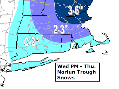
 We have got ourselves another snowfall on the way for eastern New England. A clipper is coming out of the Great Lakes tonight and tomorrow and once it hits the Atlantic it is going to explode and throw an inverted "Norlun" type trough into eastern New England. These events are very finicky and change during the actual event. That said, it looks like much of SNE will at least see some snow. The further SE and SW you live, you may see it start as rain and stay as a wet snow for the event with temperatures hovering around 32, but everyone else should cool enough to see mostly snow out of this event. Many people will have to break out the shovels for this one again and people in northeastern Mass and up onto the Seacoast of NH, you may need the plows out again. There we could see 3-6" of snowfall. There will be a spot somewhere between extreme SW coastal Maine through the Seacoast of NH and northeastern Mass that could see over six inches of snowfall. Where this band of heavy snowfall sets up will make all the difference. Either way, I think much of eastern Mass could see a general 2-3" overall. This will mainly occur late tomorrow night and into the day Thursday. Thursday could be a day that features on and off snow showers or 'snizzle' throughout the day, giving the wintery look. A few delays will be possible in Middlesex and Essex counties.
I want to stress that this is an ever evolving storm system and it will need to be watched through tonight through tomorrow and through the actual event to see where exactly this heavy band of snow decides to set up. Someone in eastern New England will wind up with up to 8" from this...where that is, is too hard to pin point at this time. Stay tuned.
No comments:
Post a Comment