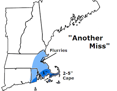
 Another storm and another miss on the way for SNE, most of SNE. The Cape and Islands look to be barely grazed by this storm system tomorrow night - Monday. Yesterday at this time, it was looking like 1-3 feet of snow was likely for much of eastern SNE and trending more and more, but we came back to reality later last night and now this storm looks to be another bust. I have an area outlined in eastern Mass and most of RI that could see some flurries, mainly associated with the northeasterly wind that could bring in some moisture off the ocean tomorrow afternoon ahead of the actual storm system. Then as you get to extreme far SE MA, then you could get to an area of about an inch of slushy mess south of Plymouth. That sloppy inch may make it up to say Bridgewater, but that would be about it. The Cape and Islands will be the 'bread winner' with this one. I'd say 2-5" is possible down that way as they will be closer to the storm, but marine air may move in and change them to mostly rain which could limit accumulations. Nantucket could see over 6" of snow still, but for now I am playing it conservative. Most computer models are going for a mainly out to sea solution right now with a few of our less reliable models still getting that heavy band of snow all the way to Nashua, NH. However, this looks extremely unlikely ATTM. No luck with this one and the next one looks to be a mainly rainstorm by Friday, sorry. We have two that go out to sea and then we get one to head to our west. Just frustrating if you ask me. That's it for now. Will update if a miracle happens, but looks highly unlikely.
 Saturday, January 26, 2008
First and Final Call
 Another storm and another miss on the way for SNE, most of SNE. The Cape and Islands look to be barely grazed by this storm system tomorrow night - Monday. Yesterday at this time, it was looking like 1-3 feet of snow was likely for much of eastern SNE and trending more and more, but we came back to reality later last night and now this storm looks to be another bust. I have an area outlined in eastern Mass and most of RI that could see some flurries, mainly associated with the northeasterly wind that could bring in some moisture off the ocean tomorrow afternoon ahead of the actual storm system. Then as you get to extreme far SE MA, then you could get to an area of about an inch of slushy mess south of Plymouth. That sloppy inch may make it up to say Bridgewater, but that would be about it. The Cape and Islands will be the 'bread winner' with this one. I'd say 2-5" is possible down that way as they will be closer to the storm, but marine air may move in and change them to mostly rain which could limit accumulations. Nantucket could see over 6" of snow still, but for now I am playing it conservative. Most computer models are going for a mainly out to sea solution right now with a few of our less reliable models still getting that heavy band of snow all the way to Nashua, NH. However, this looks extremely unlikely ATTM. No luck with this one and the next one looks to be a mainly rainstorm by Friday, sorry. We have two that go out to sea and then we get one to head to our west. Just frustrating if you ask me. That's it for now. Will update if a miracle happens, but looks highly unlikely.
Subscribe to:
Post Comments (Atom)
No comments:
Post a Comment