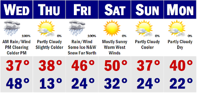
 We have definitely gone into a warmer pattern for January this year from our cold and snowy December. Our 'warm' and rainy January pattern will persist through the rest of this week and even linger into next week as well. We have ourselves a rainstorm for all coming up tonight even up North. Rain will be heaviest tomorrow morning during the morning commute. Temperatures will start in the upper 40's to around 50 during the morning, but a strong cold front will move through in the afternoon and temperatures by the evening commute will be falling through the 30's and 20's. This won't set up a frigid Thursday. In fact, Thursday will be above normal again, leading to our next wet storm with some ice possible out past ORH county and central and northern New England could see more in the way of snow and sleet, but here in SNE, it will be mostly a chilly rainstorm. It won't be so chilly on the Cape where much of your 8-14" snowpack will vanish with tonight's mild rains and Friday's storm as temperatures could come up over 50 degrees. Saturday will likely see temperatures very mild with a downsloping westerly wind, so temperatures will be in the mid 40's NW and around 50 at the east facing coasts. Then we slowly start to cool, but will still be above average. All and all, a very uneventful week for snow lovers the next 10-14 days. Check back after Februrary 8th, as by the 10th of February we could go into a more favorable pattern for cold and snow. Until then, see ya.
Tuesday, January 29, 2008
Rain, Rain, and More Rain
 We have definitely gone into a warmer pattern for January this year from our cold and snowy December. Our 'warm' and rainy January pattern will persist through the rest of this week and even linger into next week as well. We have ourselves a rainstorm for all coming up tonight even up North. Rain will be heaviest tomorrow morning during the morning commute. Temperatures will start in the upper 40's to around 50 during the morning, but a strong cold front will move through in the afternoon and temperatures by the evening commute will be falling through the 30's and 20's. This won't set up a frigid Thursday. In fact, Thursday will be above normal again, leading to our next wet storm with some ice possible out past ORH county and central and northern New England could see more in the way of snow and sleet, but here in SNE, it will be mostly a chilly rainstorm. It won't be so chilly on the Cape where much of your 8-14" snowpack will vanish with tonight's mild rains and Friday's storm as temperatures could come up over 50 degrees. Saturday will likely see temperatures very mild with a downsloping westerly wind, so temperatures will be in the mid 40's NW and around 50 at the east facing coasts. Then we slowly start to cool, but will still be above average. All and all, a very uneventful week for snow lovers the next 10-14 days. Check back after Februrary 8th, as by the 10th of February we could go into a more favorable pattern for cold and snow. Until then, see ya.
Subscribe to:
Post Comments (Atom)
No comments:
Post a Comment