 Okay, I know you did not come to this site to find out the weather for Seattle, so I will get back to Boston. I just thought it was odd that Charleston, SC and Orlando, FL and Seattle have seen their first snows before Boston or Portland, ME. Whacky.
Did that end of the week forecast get you? We will be transitioning into a much colder pattern late week and into the weekend. Timing of the front coming through will have a major effect in determing the weather for Friday. If it arrives too slow, expect highs around 60 with showery rains and then a change to cold weather Saturday morning, but there would be little time for any rain to change to snow, so I would bet with no snow. On the other hand, the front could go through our area much earlier and temperatures on Friday would plummet much earlier and any rain would likely change to some sleet and eventually snow.
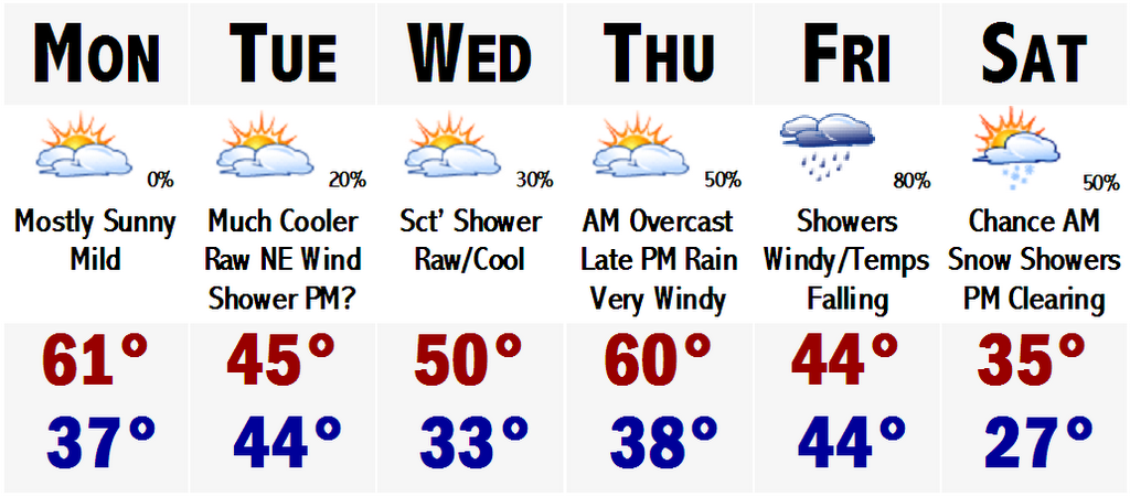
First, tomorrow will be beautiful. Mostly sunny skies with highs around 60. A front will go through on Tuesday and send us to a cool raw marine influenced weather day with highs in the mid 40's. It will be dreary and dismal. I can't even rule out a few showers and drizzle. Wednesday will be similar, but a tad warmer. A warm front will fly through SNE Thursday and temperatures will soar back to around 60-66 degrees with a busy southerly wind. Rain commences Thursday night and will continue into Friday associated with the front. Then it gets interesting as a new wave of low pressure will try to develop along the front around the Mid Atlantic. This almost always equals trouble and whacky forecasts ranging from a warm rain to other stations calling for a snow.
 Located to the left is the 12z run of the GFS computer model. The blue bar is the "540 Line." This usually correlates to the hard to predict rain/snow line. If you look at this real hard you will see that the blue line is situated through Long Island, southern Rhode Island, and southeastern Massachusetts. Boston metro is under a blue shading which correlates to 0.50" to 0.75" of "liquid." Assuming that it would be all snow, you could easily do the math and say 5-8" of snow. However, it is not that simple. This model could be a little off by 3-6 hours with passing the 0 degree C line and most of what would fall would be in the form of rain, even in this picture. However, it is a good sign for us snow geese to see this. The possibility is surely there. This 12z run is actually very unique in developing the shortwave and sending it south of Long Island and SE of Nantucket. I am not one to go on huge limbs because I know I will get squawked at for doing this, but I am going to say that there will definitely be snow in Boston come the end of this week. I am not going to say much more than that. But I will say that areas north and west of Route 128 and especially 495 have a chance of seeing their first accumulating snows during Friday night to welcome in December!
Thereafter it will get cold, for a while. How long is still in question. I will side with a weekend with highs in the mid to upper 30's before slowly moderating back into the 40's thereafter.
Stay tuned with this potential winter weather late week, but until then enjoy the late fall warmth tomorrow.
1 comment:
Well, lets just say that I will be revising this forecast.
Post a Comment