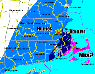
Right now my confidence of this snowfall map is medium. I am not overly confident of this forecast verifying, but I feel pretty good enough to put it out there as my preliminary forecast. Yesterday afternoon, the NAM drifted away from the big storm idea by pushing it mainly out to sea. This was the 12z run of the NAM. The GFS was still bullish on QPF for much of SNE and CNE until 6z this morning, giving some parts of our area a light to fairly moderate snowstorm. It would have been a Category 2 Storm on Henry Marguarsity's Intensity Chart. However, the latest run of the 12z GFS has taken this storm much further to the S&E with limited precipiation in our area. Having said all this, the NAM has continued to show this storm going well out to sea consistently for about 24 hours now, which is a good streak for a computer model. Therefore, since the GFS has turned away from the storm being close to the coast and other models starting to keep the storm further S&E, including the Canadian, JMA, and UKMET. I have posted a map of minor accumulations at best to the S&E of Boston, where one to perhaps two inches is still possible. The Cape is the wild card. Down there expect a gloppy coating to an inch of snow.
Thats all for now on this "OUT TO SEA" storm. Any changes or revisions to the forecast and I will be the first to post them up.
2 comments:
18z NAM is coming in and it takes the storm even further S&E. Believe it or not, with all the hype this storm had 36 hours ago, it now looks like my meager snowfall forecast may be overdoing it.
What a waste.
I am at the point where I just want this winter to end!
Post a Comment