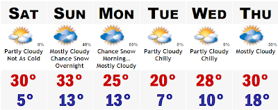
 Wow, was it cold out there this morning with lows in the single digits below zero to single digits above, with the biting NW wind at 25-35mph making it feel more like ten to twenty below zero. The good news is that we are just about done with the coldest of air. Tomorrow will be much warmer, compared to today, with highs approaching the freezing mark. We may actually see many towns surpass the freezing mark on Sunday, but there may be a price we have to pay along with the warmer temperatures.
A storm system will try to get its act together along an old stationary front in the Atlantic sometime Sunday morning. How close to the coast and how fast this storm develops along the front will determine how much and if SNE will see any snow out of this one. Right now, the computer models are pretty much all over the place, with the 06z NAM showing a moderate snowstorm in eastern SNE with an inverted trough giving us several inches of fluffy snow. However, in the 12z NAM run, it pushed that heavy band into SW CT and exiting off the Cape and Islands. Both the 0z GFS and NAM didn't even show snow for any of SNE, so we are making progress. Both 6z and 12z GFS outputs were a little more conservative on the QPF amounts as it usually is less bullish than the NAM, but still manages to give SE MA and the Cape a plowable snowstorm with many amounts greater than 2-3". This potential little sneaky storm is still about 72-84 hours away so there will be a lot of changes between now and then, but if there is a need to put out a map, I will be sure to put one out.
After the possible event on Sun-Mon, we will return to more cold weather with highs in the 20's to round off the week with another storm threat along about Thursday of next week. Stay warm.
3 comments:
Taking out the chance of snow for Monday.
Wouldn't do that, just yet. Still looks possible along the south coast, especially Cape/Islands.
Oh, yeah..the Cape may pick up an inch or two...just cancelling the snow for BOS northward.
Post a Comment