Tuesday, July 31, 2007

August Starts Off Perfectly

Tomorrow will be one of those days that you wish you could bottle up and keep for those rainy days we get in the fall and spring and snowy days we get in the wintertime. Tomorrow will just be nothing short of perfect for all season's lovers. Whether you are a winter lover or summer lover, you will appreciate tomorrow.

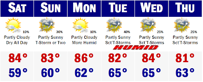
Highs will get into the mid 70's at the shores with temperatures maybe getting a degree or two above 80 degrees just inland. There will be abundant sunshine and a light breeze that will feel very refreshing. This will not last forever. Highs will get back into the 90's by Thursday and Friday. The NWS has also outlined an increased risk for severe thunderstorms around our area on Friday afternoon when a front from the northwest will try and squash the heat and humidity. It will not squash the heat as we will likely get back to around 90 degrees on Saturday, but we will cool a tad on Sunday, before we heat back up for Monday. Early indications are that we here in the East will start to bake, while the West Coast will get a chance to cool down. This looks like a good pattern shift all the way through the middle of August.

The tropics are really starting to heat up and I will have more on it tomorrow and I just want to say WELCOME KEVIN GARNETT and ERIC GAGNE. WELCOME to Boston guys.

Chantal Forms...More Development Possible Within 36 Hours

Last night, TD 3 was raised in status to a Tropical Storm. T.S. Chantal is rocketing to the northeast and will likely become extra tropical within the coming days. Chantal now has sustained winds of 50 mph.

...CHANTAL STRENGTHENS...BUT HEADED FOR COOLER WATERS...AT 1100 AM EDT...1500Z...THE CENTER OF TROPICAL STORM CHANTAL WASLOCATED NEAR LATITUDE 40.2 NORTH...LONGITUDE 62.7 WEST OR ABOUT 305MILES...495 KM...SOUTH OF HALIFAX NOVA SCOTIA AND ABOUT 660 MILES...1060 KM...SOUTHWEST OF CAPE RACE NEWFOUNDLAND.

CHANTAL IS MOVING TOWARD THE NORTH-NORTHEAST NEAR 29 MPH...46 KM/HR...AND THIS MOTION IS EXPECTED TO CONTINUE WITH SOME INCREASE INFORWARD SPEED TODAY AND TONIGHT.MAXIMUM SUSTAINED WINDS HAVE INCREASED TO NEAR 50 MPH...85KM/HR...WITH HIGHER GUSTS. LITTLE CHANGE IN STRENGTH IS FORECASTDURING THE NEXT 24 HOURS AND CHANTAL COULD LOSE TROPICALCHARACTERISTICS TONIGHT OR ON WEDNESDAY.

TROPICAL STORM FORCE WINDS EXTEND OUTWARD UP TO 175 MILES...280 KMFROM THE CENTER.THE ESTIMATED MINIMUM CENTRAL PRESSURE IS 999 MB...29.50 INCHES.REPEATING THE 1100 AM EDT POSITION...40.2 N...62.7 W. MOVEMENTTOWARD...NORTH-NORTHEAST NEAR 29 MPH. MAXIMUM SUSTAINED WINDS...50MPH. MINIMUM CENTRAL PRESSURE...999 MB.

THE NEXT ADVISORY WILL BE ISSUED BY THE NATIONAL HURRICANE CENTER AT500 PM EDT.

The area of disturbed weather shown in the yellow box still is showing some signs of development, possibly within the next 36 hours, but it does not look as good as I thought it may be early this morning. Later this afternoon and evening there will likely be another flare up of storms and we will see if these storms will be able to manage the storm system and aid in further development.

I will try to get out a SNE forecast soon, but I will tell you that we will start to warm up and by late week we will likely be in the 90's.

Monday, July 30, 2007

Tropics Heat Up!


Breaking: TD 3 Forms...Chantal Immenent

Tropical Depression number 3 has just formed out in the Atlantic Ocean. This hurricane season started off quickly with a named storm before the actual start of the hurricane season, but has since cooled off in a big way, leading to a rather "boring" late June and much of July...UNTIL TONIGHT!

This storm is not the only player out there. There is another storm that is close to formation near the Carribean and Windward Islands. If Chantal forms, it will only be an interest to shipping lanes. You can easily see its path from the NWS. Its out there and not a factor in our weather.

In this satellite infared image provided by Accuweather we can see the two disturbed areas of weather in the Atlantic tonight. The one northwest of Bermuda and rocketing to the northeast attatched to an old front that died out over the water is our new Tropical Depression 3. This storm started to get organized yesterday and now has this public information statement from the Hurricane Headquarters out of Miami, FL.
"...TROPICAL DEPRESSION...THIRD CYCLONE OF THE SEASON...FORMS BETWEENBERMUDA AND CAPE COD...AT 1100 PM EDT...0300Z...THE CENTER OF TROPICAL DEPRESSION THREE WASLOCATED NEAR LATITUDE 36.1 NORTH...LONGITUDE 66.0 WEST OR ABOUT 270MILES...435 KM...NORTH-NORTHWEST OF BERMUDA AND ABOUT 445 MILES...710 KM...SOUTH-SOUTHEAST OF CHATHAM MASSACHUSETTS.THE DEPRESSION IS MOVING TOWARD THE NORTH-NORTHEAST NEAR 16 MPH. ATURN TO THE NORTHEAST WITH AN INCREASE IN FORWARD SPEED IS EXPECTEDOVER THE NEXT 24 HOURS.MAXIMUM SUSTAINED WINDS ARE NEAR 35 MPH...55 KM/HR...WITH HIGHERGUSTS. THE DEPRESSION COULD BECOME A TROPICAL STORM OVERNIGHTBEFORE BECOMING EXTRATROPICAL BY LATE TOMORROW.ESTIMATED MINIMUM CENTRAL PRESSURE IS 1007 MB...29.74 INCHES.REPEATING THE 1100 PM EDT POSITION...36.1 N...66.0 W. MOVEMENTTOWARD...NORTH-NORTHEAST NEAR 16 MPH. MAXIMUM SUSTAINED WINDS...35MPH. MINIMUM CENTRAL PRESSURE...1007 MB.THE NEXT ADVISORY WILL BE ISSUED BY THE NATIONAL HURRICANE CENTER AT500 AM EDT."
The Hurricane Headquarters have also sent our a Public Advisory from earlier in the day.
TROPICAL WAVE IN THE E CARIBBEAN IS TILTED FROM 24N66W ALONG 15N68W TO INLAND OVER SOUTH AMERICA NEAR 5N69W MOVING W NEAR 15 KT. BROAD LOW LEVEL INVERTED-V CURVATURE COVERING THE AREA FROM 62W-75W. ISOLATED SHOWERS ARE MOVING FROM THE LESSER ANTILLES ACROSS THE E CARIBBEAN BUT NO ASSOCIATED DEEP CONVECTION IS NOTED.
Earlier, the NWS was not as concerned with this potential storm system, but looking over the looping satellite images tonight, there is nice flare up of thunderstorms around the center of circulation, which has made it all the way to the surface as a low pressure system. Now if we wake up tomorrow morning and the thunderstorms around the center of its circulation start to fizzle, we probably do not have anything on our hands, at least for the next 48 hours, but if the thunderstorms continue to explode like they are showing tonight, we could have Tropical Depression 4 the day after TD 3. Check back in the morning on both of these systems.

Sunday, July 29, 2007

Unusual Canadian Cold?

I usually do not check the maps during the summer, but I don't remember it being so cold in northern Canada during the dog days of summer. It may be totally normal, but that cold seems to stay there throughout the 15 day period, and infact seems to get stronger and more expansive by the end of the forecast period, mid August. Anyone have any knowledge of this...I'm sure it is totally normal, but cool to see the first signs of fall perhaps.

Friday, July 27, 2007

Extended Forecast


A Quiet Unpublicised Boston Heatwave

Interesting to note, Boston offically recorded its second heatwave of the 2007 Summer season today. We have had three consecutive days of 90 degrees or higher. Our last heatwave came at the end of last month and I'm sure there will be more to come. Who would have thought that we would be in the midst of an official heatwave around these parts on Monday when temperatures were in the 60's for afternoon highs! The weather can surely change dramatically around here.

Boston's heatwave stats went like this....

Wednesday's High 90

Thursday's High 92

Friday's High 92

That is an offical heatwave. Where I live in metrowest, I did not see a heatwave. Wednesday I only managed 88 degrees, Thursday I did hit 93 degrees and this afternoon I hit 92 degrees respectively. Tomorrow doesn't look like I will reach 90, likely topping out around 86 tomorrow afternoon, and Boston will likely top out around 85-88 degrees. Then the rain moves in tomorrow overnight and Sunday.

Lots of Rain...But There Will be Sun Too

The QPF for the next 4-5 days looks scary to vacationers. It really isn't though. The next 5 days, SNE stands to see anywhere between 1-3" of rainfall regionwide. It will not rain from tomorrow through Monday, but there will be times when the rain will be coming down in buckets, while other times we have hours upon hours of dry weather with sun too. The wettest day still looks to be Sunday, with numerous showers and thunderstorms and they may continue into the day on Monday as well. Both days look to be on the mostly soggy side, but even on these days, there will likely be dry periods as well. I cannot stress this enough. Although we are entering a wet and unsettled period of weather, there will be times of dry weather. It will not always be raining. The rain may come down heavy enough at times on Sunday and perhaps Monday that there is some brief street flooding. But there will also be times during the same day, possibly within hours when the pavement will be dry and the sun could be shining. So if you have plans for this Sunday or Monday, do not cancel, just have backup plans just in case. If you're having everyone over for an outdoor BBQ on Sunday, plan on having it outdoors, but if the weather turns, make sure its ok if everyone can make it inside. This unsettled weather should taper early next week and we will see the sun again. This last weekend of July, BELIEVE IT OR NOT, will feature lots of rain, but will be warm, in the 80's, so all those outdoor plans should go without a hitch, just a few rain delays.

Thursday, July 26, 2007

Showers and Storms this Weekend....Early Next Week

FRIDAY: There will be partly cloudy skies and temperatures will get to between 87-92 degrees. If Boston hits 90, its the second official heatwave of the season. Storms will develop in western New England later in the day and be in western Vermont by 4-8PM. Don't worry about these storms here in eastern New England. Boston's showers and storms will likely hold off until Saturday.

SATURDAY: Showers and thundershowers will be possible, for all of New England with the best chance of showers and thundershowers after 1PM. Some of the storms could have heavy rainfall. Highs will be in the 83-88 range, coolest down on the Cape.

SUNDAY: The wettest day of the next several with heavy rainfall. Highs should get to around 80 in Boston, but temperatures in the 70's will be found along the North Shore and Cape. Rockport, MA may stay in the upper 60's.

Thereafter, the rain showers will likely stay for Monday and Tuesday, too early to say just how widespread or heavy these showers will be. Temperatures throughout the period will likely be in the 80's, just regular summer weather.

Wednesday, July 25, 2007

Second Heatwave of the Season for Some

We have ourselves at the beginning of our second heatwave here in southern New England. Right now at 12:30PM at Boston, the temperature is sitting at 87 degrees. Barring a seabreeze, Boston will have no trouble hitting 90 this afternoon. We will do it again tomorrow and Friday, but the humidity will get very high tomorrow and Friday and it will feel much more hot than what it feels like right now. Right now the dewpoint is sitting around 60, making it only feel slightly humid. Tomorrow, the dewpoints should get into the mid and upper 60's and by Friday and Saturday, we should get to near oppressive levels, nearing 70 degrees. With the increased humidity, the threat for rain will increase as well. The upper level low that drenched NYC with 2-3" of rain this past Monday will be heading back east, this time loaded with tropical downpours. It will link up with a front coming down from Canada, which will help to wring out all of the moisture in the air. Sunday looks to be the wettest day, but the rain should start as scattered showers and storms on Saturday, mainly in western and northern New England and then migrate east by late day to get eastern New England. Temperatures will be cooler with the rain cooled air, mainly in the mid 70's on Sunday, upper 70's on Monday, but we will not have to deal with the cold air we had on Monday with highs struggling to get out of the mid 60's, very odd for this time of the year.

Monday, July 23, 2007

The Heat Returns...

Today was one of those days that makes you do a double take of the calender. The high at Boston was 67 degrees today. Thats it. That is the average temperature for October 1st. No worries, this weather will not continue forever. In fact, we should warm up tomorrow back into the 70's and then we will start a stretch of hot weather from Wednesday through Friday with temperatures in the lower 90's through the stretch. Even thereafter, we will not return to the 60's and raw conditions, but rather 80's with a chance of rain on Saturday and Sunday, beginning Friday afternoon as a cold front from Canada will try to bring some cooler weather into SNE, but may get stalled in the process. If it doesn't stall, we could totally clear out for the weekend and see mostly sunny skies with temperatures on either side of 80. I'll see what I can do.

Just to let you know, the fog tonight and tomorrow will be very dense. In some cases you will not be able to see the tip of your nose as visibilities may be reduced to feet in some areas tonight, especially along the coastline and valleys of Southern Worcester County. All areas are fair game for dense fog tonight but these are the areas that will be hardest hit, which has prompted the NWS to issue a *Dense Fog Advisory for tonight and early tomorrow morning. All the fog should burn off entirely by 8-10AM due to the strong July sun...fog's number one enemy, along with wind.

Sunday, July 22, 2007

Long Range Suggests Much Above Normal Temperatures for Lower 48

No extended forecast today, but I wanted to at least show what the NWS has outlined for a possible area of extreme heat for the next week or so. The area in red, which includes northern New England will experience much above normal temperatures in the July 23 to 29 timeframe. The eastern part of the bubble will not see high temperatures probably until the 25th. Here in SNE we should sneak to around 90 by Wednesday and stay above normal by 5 to 15 degrees for a good seven days afterward. The entire country will experience higher than normal temperatures the next 8-14 days. Its the hottest week on average this week according to records and the country will really feel these pre-Dog days of summer in a big way. Energy demand will be at an all-time high no doubt. Stay cool.

Saturday, July 21, 2007

Beach and Boating for Sunday


A Perfect Sunday

It doesn't get any more summery than this six day forecast. Temperatures in the 70's to begin then mid and upper 80's by the end of the period. The only reason those mid and upper 80's are not mid and upper 90's is because there will be a cutoff low developing in the Mid Atlantic, which will retrograte west towards the Mississippi River. This will punch the heat in the Midwest and West in the gut and prevent it from reaching the east coast at its full potential. Yesterday, it looked like that heat would make it to the coast at nearly full potential, but looking at the computer models today, searing heat is not likely for later in the week. That doesn't mean a big ridge will eventually develop later at the end of July and early in August. That heat will still be there and will need to come east eventually. To me, I want to get the cycle of east coast ridges down in mid-late summer because that means we can have a nice and cool fall and hopefully set up a semi-permanent pattern heading into the winter that would favor more in the way of snow and cold. Just a little wives tale. Hot summers lead to snowy winters. Totally unscientifically based...but who knows.

Thursday, July 19, 2007

Rain Exits to Welcome Pleasant Weekend Weather

There has been much struggle over the forecast by many for this upcoming weekend. A few days ago, I would have said, don't make those beach plans for Saturday and maybe Sunday, but tonight the optimism has come true and we will even get a nice Friday afternoon for the people getting on I-95 to go up to the mountains and down to the Cape. After a few morning showers in eastern New England, the sun will poke out in the afternoon for all of us and temperatures will be nice and mild, mainly in the low 80's. Saturday will be even more pleasant with mostly sunny to partly cloudy skies and temperatures will be very pleasant, mainly in the upper 70's, after morning lows in the mid 50's. We will finally be able to open up the windows and get a nice fresh breeze in the house. Sunday and Monday is more of the same with overnight lows in the 50's and afternoon highs in the 70's. Then we WILL start to heat up by the middle of next week. It will start gradually, but then we will really start to heat up. A massive blob of heat will encompass much of the nation and we will get into the act as well. Highs will likely get into the 90's by Wednesday. Enjoy this nice weather first. Tropics, still nothing really to talk about.

Wednesday, July 18, 2007

A Good Weekend Afterall?

Today we really dodged a bullet. The heaviest of the rainfall was on the South Coast of New England and on Long Island this morning. The rain came down so heavily in New York City that it caused many roadways to flood and cause traffic nightmares on the freeways. Parts of Long Island saw between 3-5" of rainfall, that pretty much fell in a 2-3 hour timeframe. There was also an EF 1 tornado in one small town on Long Island. That heavy rain and thunder extended almost to the South Coast of CT and RI and exited off the Cape and Islands with a little heavier rainfall, but not what they saw in New York City and Long Island. Just imagine if that rain and thunderstorm band was just a little farther up to the north to affect the Worcester, Providence, and Boston metro areas. It would have been a soggy mayhem here with major traffic tieups. Instead, much of SNE just saw a 1/2" to 3/4" of rainfall. To the north of the city, less than a 1/4" fell.

Tomorrow will not be a wet day. In fact there will be extended sunny breaks that will be all enough to proprell that temperature into the lower to mid 80's. There is a chance of isolated thunderstorms in the afternoon, but they will be few and far between and on the move from west to east as well. If you get under a thunderstorm tomorrow, it wouldn't last more than 15 minutes, with heavy rain and sun thunder and lightning. Then it would clear out and the sun would likely come back out. It does not look like a situation that a Watch would be necessary.

More rain with the final front will come through sometime on Friday. The exact timing of the front is unknown at this time, but it would be sometime during the day on Friday. Accompanying the front, there will be rain and thunderstorms that will move through southern New England, that looks to amount to no more than a 1/2" to 3/4" of rain again regionwide with up to 1"+ in some areas that have more influence from thunderstorms. It now looks like that front will keep on moving on out to sea and not stall of the Cape and generate low pressure systems with heavy rains as it looked yesterday.

Instead, it looks like the front will safely clear the coast late Friday night and early Saturday morning to have clearing likely taking place first thing on Saturday morning from west to east. By early afternoon on Saturday, I would expect all places in SNE to be under at least partly cloudy skies. Sunday looks to be a mainly dry day as well, leading to warming temperatures early next week.

Thats all for tonight, more tomorrow.

Tuesday, July 17, 2007

Stormy Wednesday...Major Heatwave Looming?

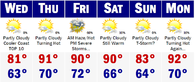
The nice couple of days that we have had will be all but a distant memory come later this week. The rain and thunderstorms that I have been barking about for a while now are poised to move into southern New England tomorrow, moving first into western and northern New England and then moving towards the south later in the afternoon. The storms could actually be rather strong to severe in northern and western New England in the early to mid afternoon hours, but they should weaken somewhat as they move southeast and move in on Boston and Providence and eventually down to the South Coast and Cape and Islands. By then the showers will be nothing more than showers with a few rumbles of thunder and locally heavier downpours. This will continue much of tomorrow night, occaisional showers and downpours and the rain will slowly start to add up on us and actually help Boston's rainfall deficit from June 1st, which is nearly 2-3" at the current time. Within this week, Boston should at least add a couple inches of rainfall, if not a little bit more. The next rainiest day looks to be Friday afternoon and evening with a similar setup as Wednesday. The rain may linger on the South Coast early Saturday before I hope we can at least salvage Sunday for vacationers going to the Cape and beaches.

No fear for beach-goers though. Although the middle and end of this week may not be a good beach or vacation week, things may be looking up, and WAY up for later next week. Well, if you have been watching the news lately and have been seeing the West absolutely bake in triple digit temeperatures and the wildfires have been rampant, that heatwave is about to make its move and make it towards the populated areas east of the old Mississippi, sometime later next week.


Now details with this potential significant heatwave are still primative, but things are starting to look like it will get really hot around this parts. This is a graph, temperature outlook for the next 8-14 days. As you can see, the Northern Plains, Great Lakes, Mid Atlantic, and Northeast will really start to bake. Some computer models are pushing this massive blog of hot air towards the Northeast by the middle of next week and others hold it off for another 2-4 days. Either way, it will get here and it will get HOT. I was looking at the extended outlook for Chicago, a city that will see the heat before us by a couple days. Well, they are under a Flood Watch tonight and they are seeing "cool" temperatures, mainly in the 70's the next few days. But by later next week, early next week, they will start to bake. Temperature forecasts for them get into the 90's by Tuesday or Wednesday of next week and the far outlooks keep them in the 90's, mid to upper 90's as a matter of fact, for the next 7-10 days consecutively. Overnight lows will likely struggle to get below the mid 70's to lower 80's later down the stretch for Chicago.

Now I am not say that Boston will see a 10 day heatwave of temperatures in the upper 90's with overnight lows around 80, but we will get temperatures to above to well above average once we get this unsettled pattern we are dealing with right now over with, which should be early next week, just a Chicago and the other Great Lake cities start to really heat up. This goes into the end of July and the first part of August could be quite warm to say the least as well.


All the while this is going on, the extensive heatwave that has been going on in the intermountain West will start to break down, if not just move east by 1000 miles and the jet will back into the Pacific Northwest and deliver a couple summer "winter-like" storms into cities like Seattle and Portland, Oregon, making a rainy part of their dry season. One storm that will hit them later this week, will actually carry rain from cental and northern California to Seattle. Temperatures will be in the 60's and 70's as well. The intermountain West will still be hot, but places like Salt Lake City will not see consecutive days of 100+, instead they will drop to around 90. The 90's and 100's will be repressed.


All that heat will be coming East. Get ready, get set, its almost our turn.
Monday, July 16, 2007

One More Beach Day, Rain Moves in Wednesday

Tuesday will be the last real nice day for a while. Carpe Diem. "Seize the Day." You will want to. Highs tomorrow will be in the mid to perhaps upper 80's. The UV index will be very high again tomorrow and you will burn easily again. The rain and storms really move in tomorrow night and early Wednesday. Like I said in the earlier post, Wednesday will be a rather wet day, no a washout, but a fairly wet day with showers and thunderstorms and times when the rain will be coming down in buckets. However, there will be times when the pavement will start to dry out as well. Thursday will not be as wet as Wednesday, but there will be a few downpours possible and overall a mostly cloudy and good day to go see Harry Potter or something.

Friday will be wetter than Thursday and perhaps Wednesday with the stalled front moving in another batch of moderate to heavy rainfall with showers and thunderstorms. The rain in most areas on Friday will be falling in inches. The rain should start to taper by Saturday and the sun may make an appearance in the afternoon, but will surely come out by Sunday with cool temperatures. All said and done, the rainfall totals by Saturday should range from about 3-6" in much of SNE, to a good 1-3" in NNE. It won't rain all the time, but the rain will add up when it does fall.

Heavy Rains and Flooding Later this Week?

This is a QPF map from the NOAA site and it is showing a whole heck of a lot of rain that is forecast to fall in a 4-5 day timeframe, starting Tuesday and ending Saturday. In total, in the 4-5 day period, parts of New England, especially southern New England, could be seeing rainfall amounts on the order of 4-6". A half-foot of rain could pose a risk of flooding.

It will not rain straight on through the period, but there will be bouts of showers and heavy thunderstorms, that will have this rain fall in a short time period. We will likely see an inch of rain at a time. The first day with a chance of showers will be later on tomorrow night, but it is a small chance and most places will be dry during the day tomorrow. A few evening showers and thunderstorms, especially in CT and RI will be possible, I would say a 25-40 percent chance. Then Wednesday will be a rather rainy day with showers and thunderstorms, locally heavy, pretty much all day which will yield quite a bit of rainfall before a semi dry day on Thursday, yielding another pretty wet Friday and Friday night with more heavy rains and thunderstorms, but there will be completely dry periods on both Wednesday and Friday. It will not be raining the entire day. It will be very wet though and during peak rainfall, street and urban flooding will be possible. It will also be extremely humid as well after today with dewpoints getting back to the oppressive levels by Wednesday through Friday and Saturday. Dewpoints will likely be in the 68-72 degree range. It will feel gross.


Sunday, July 15, 2007

An Unsettled Week Ahead

An unsettled week is ahead for southern New England, but tomorrow will be the one exception, with possibly Thursday being dry as well. Tomorrow will be one of the BEST beach days of the summer season regionwide with temperatures getting into the mid to upper 80's regionwide. There will be abundant sunshine too with a UV index very high around a 9. This means you will burn in the sun in about 15-20 minutes. Use SPF 30-45.

Then we get unsettled with showers and thunderstorms possible each and every day through Saturday, with the exception maybe being a dry Thursday. Temperatures by this weekend will cool off dramatically as well. Highs by the end of the week will be stuck in the 70's here in eastern Southern New England with near 80 degree readings out West. Highs on Saturday at the coast could struggle to get above 70. Still a long way out, so lets just play it by ear.

Enjoy the day tomorrow. Its going to be a summertime treat.

Severe Weather Likely this PM...Watch Likely

The above picture is courtesy of the NOAA/NWS Storm Prediction Center and is a mesoscale depiction of where watches will likely be placed this afternoon. Within the blue bubble, which includes the cities of New York, Hartford, Providence, Boston, Concord (NH), and Portland, ME, a *Severe Thunderstorm Watch is LIKELY this afternoon and could be issued within the hour.

The NWS for SNE has recently issued a Special Weather Statement and goes as follows.

...SEVERE THUNDERSTORMS ARE POSSIBLE ACROSS PORTIONS OF SOUTHERN NEWENGLAND THIS AFTERNOON AND EVENING...

THERE IS A CHANCE OF SEVERE THUNDERSTORMS ACROSS INTERIOR SOUTHERNNEW ENGLAND THIS AFTERNOON AND EVENING. THE MOST LIKELY FORM OFSEVERE WEATHER WILL BE STRONG STRAIGHT LINE WIND GUSTS WITH SOMELARGE HAIL...POSSIBLY A TORNADO. THE BEST CHANCE FOR THUNDERSTORMSWILL BE IN WESTERN...CENTRAL AND NORTHEASTERN MASSACHUSETTS...SOUTHERN NEW HAMPSHIRE...NORTHERN CONNECTICUT AND NORTHWEST RHODE ISLAND...WITHSMALLER CHANCES IN SOUTHEASTERN MASSACHUSETTS AND SOUTHERN RHODEISLAND. THUNDERSTORMS WILL BE MOST LIKELY BETWEEN NOON AND 8 PM.

SKYWARN SPOTTER ACTIVATION HAS BEEN REQUESTED. PLEASE SEND REPORTABLECRITERIA TO THE NATIONAL WEATHER SERVICE. ~STRAUSS

So be vigilant today, watch the sky, and be safe.

Saturday, July 14, 2007

Rockin' Storms Sunday Night

First, I want to talk about the storms that are possible with a cold front moving through SNE tomorrow afternoon and evening. Ahead of the cold front, clouds will build up and showers and thunderstorms, a few severe, will develop tomorrow, first in western and northern New England. The storms will likely start in upstate New York, migrate into northern Vermont and New Hampshire and try to survive the trip southeast into SNE. The best chance of seeing heavy thunderstorms will likely be better the farther north and west you go from Boston. Inside, south and east of Boston, the showers will likely fade to lighter showers, with a downpour possible, but no risk of severe weather.

After that we have a nice Monday before a little more unsettled weather with a stalled frontal system Tuesday and Wednesday before we clear out for later next week and will be basking in low humidity and warm temperatures by Thursday and Friday, and likely extending into next weekend.

The TROPICS, don't worry...no development to worry about for at least another 7 or more days.

Friday, July 13, 2007

Nearing the Dog Days...

A typical summery week is likely this week. Temperatures will be at very summery levels, mainly in the lower to mid 80's through the period and overnight lows will likely stay in the low to mid 60's. On a few days there will be a chance of a thunderstorm or two with increased humidity in the air by early next week, but other than that there is nothing to really talk about concerning the our weather here in SNE. We got it easy compared to the people dealing with the massive flooding in the lower Great Plains, in Texas and the severe heat and drought conditions of the Southeast and Southwest. The Northwest is under an intense heatwave as well right now with temperatures every single day getting the century mark. A typhoon is forecasted to slam parts of Japan in the coming days as well with winds in the range of 110-120 mph. The island of Okinawa could face the worst of the storm with a direct hit.

You see, we have got it good here in Southern New England.

Wednesday, July 11, 2007

Drier Weather on the Comeback

The humidity of the past few days is going away. Tomorrow, any showers will quickly exit the coastline and the sun will come back out no later than 11AM-1PM. Temperatures will quickly shoot into the lower 80's in the afternoon with dewpoints back into the lower 50's, which will feel quite nice from the near 70 degree dewpoint of this evening.

Showers and thunderstorms could make it into SNE Friday night and early Saturday morning, yielding to a nice cool afternoon on Saturday. That will be the last of the nice weather because on Sunday we are back to the steam heat and we could be in its grips for quite a while thereafter.

Tuesday, July 10, 2007

Staying Unsettled

The storms did not materialize here in SNE this afternoon. It looked like we would get a few strong storms to get into at least western and central SNE, but that never really happened. There were a few storms that developed out by Springfield, but they did not really materialize well. There was a Severe Thunderstorm Watch for a while in western and northern New England, where there were a few severe thunderstorms that moved from SW to NE. Most of the major storms stayed in Vermont and western New Hampshire. This evening, the storms are diffusing and its getting quiet out there. No storms will interupt your sleep tonight.

There will be a similar threat for tomorrow with PM thunderstorms and showers. These could be quite heavy in western New England, go figure. Western MA, and VT and the Capital District could see heavy rainfall amounts, localized in the 1-2" category, with isolated higher amounts possible. There will be less in the way of rainfall for eastern New England, but there will be the same risk for strong to severe thunderstorms in the afternoon for everyone, including eastern New England, including Boston, Providence, Portsmouth. The showers will end on Thursday before a good Friday and then we could be back in the rain for Friday night and the first part of Saturday. Thereafter, we remain unsettled. It won't be raining all the time, or even 30-40 percent of the time, but there will be a constant threat of showers and thunderstorms for the next 5-7 days.

Monday, July 09, 2007

Second Round of Severe Storms Tomorrow?

Today's storms this morning rumbled through and quite frankly, I though that would be it. However, that was not the case. The stubborn front stayed west of eastern New England, just head out to Worcester and temperatures this afternoon were approaching 90 degrees. Move inside Route 495 and the temperatures never really got out of the 60's and its been a really raw day. Thunderstorms developed in northern New England and moved southeastward into northern Massachusetts. The weaken as the move into the marine air, however. A few may move through tonight and then the front will push northeastward early tomorrow morning to get Boston to around 90 degrees tomorrow afternoon.

Places further out west including Springfield and Hartford will likely get to between 93-97 degrees. Eastern New England will feature temperatures in the 88-92 degree range. Thunderstorms, some very strong to severe will develop in the afternoon and hit some places while missing others. How they develop tomorrow will determine who and when towns will be hit.

More showers and storms come through Wednesday night into early Thursday with the passage of a front that will kick all of this steamy air out to the Atlantic Ocean. Highs by Friday will be nice and mild, near 80 with very low humidity. Nothing better.

Sunday, July 08, 2007

Low Confidence Forecast

This forecast is made with very low confidence. SNE is right on the threshold between record heat and cool summer air. On one side of the warm front we see temperatures in the mid to upper 90's with heat indices well over 100 degrees. On the other side of the front, temperatures will be very cool, mainly in the lower 80's and right along the areas of the coastline, temperatures will likely hold in the upper 70's. The differences between having a high of 97 and 78 can be as close as 10-20 miles in extreme cases. Lawrence may see a temperature tomorrow of only 83, while just down the road in Framingham, the temperature skyrockets to around 95. It can be that extreme and pegging a number is so far beyond me right now. Yesterday I though that the front would be well into CNE and NNE, but today it looks like it will be dividing SNE in half.

I am more confident that we will be on the warmer side of the front on Tuesday, but how high temperatures respond is too early to tell. Likely the warmest parts of New England the next 3-4 days will be SW New England. The CT River Valley will really be baking with temperatures in the 90's each and every day through Wednesday it looks like at this point. I can see Boston getting to around 90-92 degrees. If by chance I am wrong tomorrow and Boston does hit 90, and they do it again on Tuesday, it would be an official Heatwave. Too early to tell. Temperatures will still be warm on Wednesday with 90's SW New England, upper 80's in the middle of SNE and 70's/80's in the North.

Thursday will be the transition day with morning showers widespread before we set the table for a really nice weekend with temperatures in the 70's with dry crisp air. It will be a nice reprieve from the heat and humidity we will endure the next few days.

Good thing the All Star break is upon us too because the Sox looked pretty flat against the Detroit Tigers this past weekend, likely getting swept. The Red Sox, as good as they seem, have the same exact record as they did this time last year. Makes you wonder.

Saturday, July 07, 2007

Excessive Heat on the Way

The hottest weather of the year seems to be on the way for SNE. It first comes later tonight with the warm air moving into SNE with a few showers. This will introduce the humidity again and temperatures tomorrow will get back to around 90 degrees. Then we will have the hottest day of the summer.

Monday will start out very sultry with temperatures likely in the mid to upper 70's regionwide, even in the suburbs. Even the coolest suburbs will likely stay above 70 for an overnight low temperature. That will be a good launching pad for temperatures to really heat up here in SNE, well into the upper 90's to around 100 degrees. The humidity will be extremely high as well with dewpoints around or slightly over 70 degrees, making it feel even more oppressive. Heat indices could easily get to between 105-110 degrees on Monday afternoon. It will be that bad, and we could be dealing with very unhealthy air qualities for most people, not just the unusually sensitive. All of us will be suffering from the extreme heat, and it could prove to become quite dangerous. To escape the heat on Monday, go North. Northern New England will likely only be in the 80's and parts of northern Maine will likely be only in the mid 70's because of the front will be up there with showers and thunderstorms throughout most of the day. Northern New England at this time will be the battleground and the showers and thunderstorms will be pretty heavy with rainfall amounts possibly in the 1-2" range. It will be localized, but Monday could be a pretty rainy day for most of you up there who are hiking, fishing, or just up there to escape the heat on vacation.

Then Tuesday, Wednesday, and Thursday will be a low confidence forecast. Right now I am going with SNE being on the hazy, hot, and humid side of the front with temperatures in the 80's to around 90 degrees throughout the period. However, if we get on the other side of the front or are anywhere close to the front, showers and thunderstorm could be more widespread and temperatures could be a good 6-10 degrees cooler than advertised on the forecast above. Either way a front will move offshore of the eastern US and bring an end to all this heat, possible heatwave for Boston, not sure at this time. New York City on south, through Philadelphia which is under an Excessive Heat Watch at the present time through Baltimore and Washington DC and Virginia and North Carolina could be seeing this excessive heat from today with temperatures in the mid 90's and then warm up to near 100 degrees from Sunday through Thursday! It could be a heatwave for them of epic porportions.

We will likely see a regular period of New England summer heat, but it will send our power plants into overdrive as demand for electricity will be going through the roof the next week at least. By next Friday, we will start to cool down and the heatwave will be all but a distant memory. The beaches will be packed!

Friday, July 06, 2007

Severe Storms Poised to Move into SNE Early this PM

Widespread thunderstorms, many severe have developed in northern New England late this morning and early this afternoon. There are about a dozen counties in northern New England with a *Severe Thunderstorm Warning. The NWS out of Taunton has not issued a Watch, but I do see it prudent to tell you of the storms that are developing into a line at this time and heading towards SNE.

Right now there is a pretty nasty line of storms, in a hook echo, in southern Vermont, moving SE at this present time. These storms will have wind gusts easily over 60mph if not higher. These are attached to a greater line of severe thunderstorms that extend into northern New Hampshire and Maine. There is an intense complex of thunderstorms that is just about ready to enter North Conway, NH. It is too late for hikers up there, but if you are fishing or plan on going hiking anywhere in the north-central NH region in the next one to three hours, I would strongly advise you to stay indoors or seek shelter if the storms arrive and you are caught in the elements. These storms can sneak up up you and are very dangerous if you are caught outside fishing or hiking without the proper shelter. Lightning kills way too many, a sad fact of life.

These storms will continue to move southeastward towards the coastline later this afternoon. If these storms hold together, we will see extremely heavy rains, strong winds, frequent lightning, and even the possibility of small to medium sized hail.

Again, I am emphasizing that the NWS has not issued any type of Watch for SNE, but I warn you that it does not take a Watch to get severe thunderstorms. Northern New England is experiencing that fact right now with widespread warnings.

Be safe. When you hear the thunder, get inside.

Hazy, Hot, and Humid

Hazy, hot, and humid conditions are likely from tomorrow through the middle of next week. The a/c's got there break the past five days, but it is back to work for them as they will be working overtime and our electric bills will be going through the roof once again. Power usage will be at a very high level through the stretch.

Tomorrow will be the first day in series of days that are very warm and sticky. It won't be really hot, temperatures will be in the mid 80's. We really start to warm up on Sunday with temperatures in the lower 90's. The humidity will be very high with heat indices in the mid to upper 90's. Monday will be a couple degrees warmer, mainly in the lower 90's again. At this time, there could be some very heavy rain and thunderstorms in northern Vermont, New Hampshire, and Maine. Some of the high level cloudiness could get involved in the sky here in SNE, so this will limit or cap temperatures in the low to perhaps middle 90's. Otherwise, temperatures could have come close to hitting the century mark on Monday. We have one last real warm day on Tuesday with temperatures getting around 90, or slightly above. If Boston hits 90 degrees all three days, we have got ourselves our second heat wave of the short season so far.

I don't think Boston will do it, but towns just away from the coast, like Bedford, Brockton, and Taunton could easily reach the heat wave status by Tuesday, helping to put this summer in the books as a hot one. Later next week we will cool down a bit, getting back to 80 by Thursday.

Thursday, July 05, 2007

Severe Thunderstorm Watch Until 9PM

A *Severe Thunderstorm Watch was posted by the NWS out of Norman, Oklahoma around 3:35PM this afternoon. The watch will expire around 9PM. Thunderstorms have developed and are now in western CT and northcentral Massachusetts moving east ever so slowly and gathering steam all the way. The thunderstorms will arrive in eastern MA, including the Boston and Providence areas around 7PM.

Heat Turns Up Early Next Week...

The heat will be on again early next week. We will feel the onslaught of the heat to round off the weekend with temperatures getting to around 90 degrees by Sunday. Monday will be the hottest of the stretch with temperatures getting all the way into the middle 90's and since this is a good four-five days away, I am playing this forecast conservative. Temperatures could easily get into the upper 90's. The humidity will be very high at this time as well, with dewpoints getting back to around 70 degrees.

It is really feeling sticky today and the dewpoint is only in the mid 60's, a far cry from the crisp and comfortable dewpoints from the past few days that were in the mid to upper 40's. We have a small chance of making this our second heat wave in Boston with close calls of 90 degrees for Sunday and Tuesday and possibly Wednesday. It should cool off later next week though.

Just for mention, the tropics looks ominously quiet at this time with very little if anything out there at this time. There are only a couple tropical waves that have zero chance of developing, so not to worry, the calm spell continues.

Wednesday, July 04, 2007

Warm and Humid Doldrums of July

The weather for the next week will be of a typical week in July. Temperatures will be warm, mostly in the 80's throughout the period. Tomorrow will be the most rainy day with the most rain in the morning, but then there could be a few showers in the afternoon and the same is forecast for Friday. Then its hot to round off the weekend.

Happy 4th of July everyone!

Tuesday, July 03, 2007

Happy Fourth of July

Happy Fourth of July everyone! I'm getting this post out tonight because I know many of you will be out and about tomorrow for BBQ's and parties for the Fourth. It looks like we will get all the day activities off without a hitch here in SNE. Showers will not arrive in our area until between 8-11PM. The showers at this timeframe will be scattered and moving so if it does rain, it would not rain for more than 10-15 minutes at a time. Still though if you are going to see fireworks at this time and you don't want to get wet or cold, I may advise you to bring an umbrella or even a raincoat, sweater, or jacket.

THE FOURTH OF JULY '07
TIMELINE
8AM Breakfast: Partly Cloudy...Lower to mid 60's
10AM BBQ Prep: Partly Cloudy/Mostly Sunny...Lower 70's
1PM Pooltime/Lunch: Partly Cloudy...Clouds move in from the West...Around 80
Early BBQ's: Becoming Mostly Cloudy...Lower 80's
Horseshoe Tournament: Mostly Cloudy...Mid 70's
Charles River Fireworks: Scattered Showers...Around 70
Rain for Thursday.


July 4th Miracle

We may just have a miracle worked out for the Fourth. After days of looking very bad for the holiday, the tides have turned. For the best. Rain and thunderstorms will infact hold off until Thursday for Boston and its suburbs. The further N&W you go into western New England, the higher the chances of having the holiday interrupted by rain. For Boston, it looks like we will likely get off the fireworks dry around 10-10:45PM, Wednesday night.

The rain will likely come into eastern New England sometime after midnight. It will last for a while thereafter, so enjoy our break the next couple days. But no worries, we return to our crisp air from Canada the second half of the upcoming holiday weekend.

Monday, July 02, 2007

The Fourth Saved?

Latest information suggests that many of our BBQ and outdoor plans for the Fourth have been revived. After yesterday's post, the computers kept pushing back the timing of the rainfall by hours and hours. It now looks like the daylight hours of the Fourth will be mostly if not totally dry for much of SNE and even CNE. Far NNE near the Canadian border may have showers, but that would be the worst of it. Rainfall with the front will not make it into the Boston and SNE area until much later in the night of the Fourth or even the early morning hours of the 5th.

That said, it does look like we will have a very rainy day on the 5th, Thursday. It still looks like a good 1-2" is on the way for SNE. The rain will be pushed back until Thursday, but that means we will not totally clear out until Friday or Saturday. The rain will become more showery on Friday and Saturday with warmer more humid air invading into New England. Temperatures will likely be in the lower 80's by Friday and into Saturday, but showers will be prevalent and some could be heavy with a few thunderstorms. With this type of forecast, we cannot be sure of what is going to happen until 24-36 hours out, a good point made by meteorologist Matt Noyes on the morning NECN weather forecasts this morning. At this time of the year, the computer models aren't as solid with the well defined storms of the wintertime. We have to give the computer models a better margin of error and hold off on making concrete forecasts until literally the day before, and even then with showers and thunderstorms forecasted, the forecasts can't be 100 percent certain.

That said, it looks like our prayers have been answered and we'll be saved for the Fourth.

Sunday, July 01, 2007

A Rainy Fourth...

I wish I had better news for you. Right now it looks like the Fourth could be quite stormy with a widespread coverage of showers and storms or even a steady rainfall. Temperatures would be much lower if this does in fact come as a steady shield of rain. Temperatures would probably not get out of the mid 60's, but for now I think there will be some dry periods which will allow the temperature to get into the low 70's. It looks like the rain could be long lasting with the warm front taking a while to get through all of SNE. After the front moves through Wednesday night and into Thursday, the rain will definitely become less widespread and it will become much more showery. Thunderstorms will be more prevalent as well with increasing humidity.

First, tomorrow will be remincent of mid to late September. Early morning temperatures in the suburbs will likely be right around 50 degrees. Highs will only make it to around 70 degrees with abundant sunshine. It will feel crisp and make you think we are heading towards Labor or Columbus Day, not Independence Day. Tuesday will be a tad warmer with highs in the mid to upper 70's before the mess for Wednesday through Thursday. Just throwing it out there, but the rainfall totals could be quite significant.

Right now I would say that in this two day period we could be seeing about 1-3" of rainfall, heaviest in SNE, away from the South Coast, Cape and Islands. If we do see thunderstorm coverage, the rainfall totals could be more significant and 3"+ totals would be localized and localized flooding could become an issue.

I know that you do not want to hear this for your Fourth of July plans, but it is something that looks nearly certain at this time. We will have to make our plans accordingly and outdoor BBQ's could be put in jeopardy. I remember the last real rainy Fourth. I believe it was back in 1996. July 4, 1996 was a miserable day with heavy rains and cool temperatures. It was also the day the movie Independence Day came out and everyone went to go see it that night. The theaters were packed. Another movie Fourth? Maybe, but don't scrap plans just yet. Maybe we can push this whole mess to Thursday.