 1PM UPDATE - My snowfall forecast from this morning had to be thrown out. NWS out of Taunton is downplaying this storm system greatly with their 12:15PM Update. They are saying it is going to be hard to get over 1-2" of snow inside Route 495 with this storm and what does fall will be washed away. I have stuck by the models that were showing mostly snow for areas north of the Mass Pike, but the 12z GFS came out and has the rain/snow line all the way into southern VT and NH. The NAM still has that rain/snow line south of the Pike, but I have seen the NAM lag in this department and is overdoing the cold air, as usual. That rain/snow line will probably make it as far north as Nashua or Manchester, NH at the height of the storm, but the sleet will be the major factor that limits snowfall accumulation in SNE. For when it would be cold enough to support all snow even into Boston, the upper layers will warm enough to produce a sleet storm. Unfortunately, that is how it is looking now. I'm going to stick by this map until I see new data either bringing in more warm air or cold air. Yesterday the trend was for colder and colder, but today the trend has been in the other direction. Warmer and warmer. I wouldn't be surprised if I had to lower these snowfall accumulations for SNE.
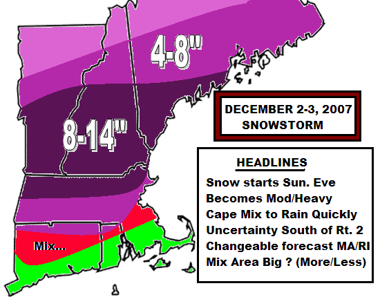
South Shore, Cape, South Coast.........Brief mix to rain
Central CT to inside Route 128.......Mix to mainly rain; maybe an inch
Outside 128 through Worcester County....Snow to Sleet; 1-3"
Southern NH and VT.......Mainly Snow to some Sleet; 4-8"
Ski Country in VT, NH, and ME......Heavy Snow; 8-16"
All areas may end as snow on Monday afternoon, but accumultions would be limited as there is not much moisture after noontime Monday. This one just didn't pan out for SNE.
200 comments:
Post a Comment