 This first computer model is from the 12z EURO model. As you can see, it does dip that trough enough to develop a fairly good storm, but the progressive flow keeps that storm system moving offshore as it strengthens. This image is for sometime around midday Saturday, the 10th of November. Without the precipitation forecast, I would expect little to nothing in the way of precipiation with this model outcome, but there may be enough to throw a few sprinkles and flurries in towards southern New England, especially south of the Massachusetts Turnpike, I-90.
The EURO's 12z is an in between the more aggressive GGEM (Canadian) and the meager solution on the GFS, the American model. The GFS keeps a very progressive NW flow as the clipper moves along as a dry area of low pressure mainly with lake effect rain/snow showers. The GFS does develop a storm, but it develops it way out to sea and not even a real threat to boaters near the coast. The next grid of computer model will be the GGEM. This is the one going gangbusters with a big dip in the jetstream as a low pressure will get cranking right around Nantucket, bringing in NE gales to the coast. It would be a quick mover, but would deliver a good thumping of heavy wet snow over the interior of southern New England and even light to moderate snow over Central New England and Maine, bombing out the storm as it heads towards Nova Scotia.
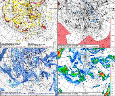 The GGEM is much more aggressive with the deep trough developing, making a huge ocean storm, alla the Nor'easter solution. I am not sure if this will pan out because it is the extreme, delivering a massive early season snowstorm to parts of southern New England. That said, I am not quite yet buying the GFS solution for it is basically not picking up the storm on its OP run yet, but it is showing an amplification along the East Coast that could support cyclogenesis development. Its just not showing anything at this point, both the 12z and 18z OP runs, but this mornings 06z OP run was looking more like the GGEM OP run.
 Of note, around this period, the NAO is to go from positive towards negative and likely being nuetral around November 11th or so. When the NAO goes from positive to negative or negative to positive, through neutral, that is when we usually get our biggest storms. This is just something interesting to note.
Right now, I wouldn't rule anything out for this weekend. We know how all the models were taking Noel out to sea for much of the week until about two days before the event, so we will see if it doesn't just do the same with this one as well for this weekend.
1 comment:
The new QPF came out
- you can find it at QPF FORECASTS AND MAPS on the side links -
It is showing the storm taking shape S&E of southern New England extending an area of light to moderate precipitation all the way past the NW suburbs of Boston and Worcester.
Earlier in the day, this 5 day forecast was showing "EL NADA" so it could be a trend....
Most of the tv people are kissing this goodbye and saying its out to sea or not even mentioning it, Pete Bouchard 7 News....
We will see how this works out in the morning.
Interesting to note, THE FARMERS ALMANAC says light snow sweeps into southern New England during the exact time frame this clipper would be, spreading in our first snow of the season.
Boston Forecast Discussion says we will have a good handle on this tomorrow afternoon and evening.
Cross your fingers...
Post a Comment