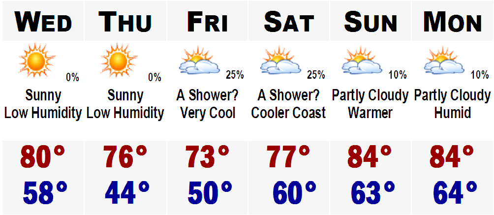
 Wednesday will be another beautiful day with low humidity and mostly sunny skies with highs near 80. Thursday through Friday will be much cooler with temperatures during the day only in the 70's with a fresh Canadian airmass. The cold will peak, or bottom out, on Thursday morning when temperatures will range from the low 40's in SNE coldest valleys and suburbs like Bedford, Norwood, and the cranberry bogs on Plymouth. Inside Rt. 128 temperatures will likely be in the upper 40's and in downtown Boston, temperatures in the mid 50's are likely.
After Saturday, we will turn the switch back to summer as highs will soar back into the 80's with increasing humidity.
 Tropical Depression 4 developed yesterday and before I posted on it I made sure that it would survive the night as it had to battle adverse conditions including dry air off of northern Africa and sheer from the NE. Well, it survived the night and could be strengthening into T.S. Debby within hours as it only need 4 mph more to reach T.S. status.
Once reaching T.S. status it will continue on its WNW, more NW, route following the base winds of a huge area of High Pressure located in the middle of the Atlantic. Following the base of the High, it will be strengthening and 5 days out we could be talking about HURRICANE DEBBY, the first hurricane of the 2006 Hurricane Season. It will be approaching Bermuda at this time and we will have to see if it wants to continue on a WNW route or take the turn to the NNE and spare the Northeast Coast.
Only time will tell. More updates in the days to come.
No comments:
Post a Comment