 Our stretch of beautiful weather is continuing with the first anniversary of Hurricane Katrina lurking. That will make the mini rainstorm we are about to face tomorrow night and Monday morning nothing to get mad about. Rain tomorrow will begin anytime after 3PM, but expect the rain to begin in earnest around 5-6PM. Tomorrow night will be pretty much a washout, but thats okay because many of us don't have plans outside at that time. Rainfall amounts of one-half to two inches is likely by Monday noon. Expect the highest amounts in Worcester County and western and central Massachusetts.
 Monday afternoon will start the clearing process and highs Monday will make it all the way to the mid 70's, a nice rebound from the mid 60's Sunday. Next week looks to be generally clear with highs in the 70's and lows in the 50's. A very seasonable end to the tranquil month of August we just had.
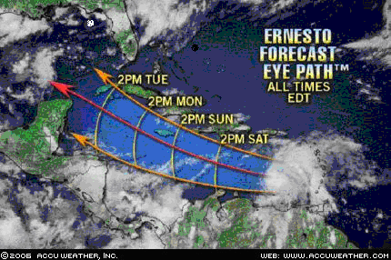 T.S. Ernesto is gathering steam as it heads through the Carribean. Winds right now are at about 50 mph. It should follow that general track shown above from Accuweather.com and should reach hurricane status by the time is approaches or passes Jamaica, with winds of about 75-80 mph. If it follows the track above and is unaffected by the wind sheer from a high just ESE of Florida, it could be entering the sheerless, very favorable for development, Gulf of Mexico, which water temperatures are in the 82-88 degree range. Basically bathwater and fuel for Ernesto. It could be entering the "gas station" with winds already approaching Category 2 status. This storm could easily reach major hurricane status, Cat. 3 or higher, and could reach it easily and head straight for mainland U.S.
Right now if you were in Jamaica, western Cuba, or on the Yucatan, I would pay very close attention to this thing. Then the focus will shift to the Gulf Coast of Mexico, south of Brownsville, TX, and mostly the United States. The main areas on the US Gulf that should pay closer attention to this would be anywhere from Galveston/Houston, TX to New Orleans, LA and Gulfport, MS. This could be a major disaster for areas affected by Hurricane Katrina and even areas forgotten by Hurricane Rita in western LA.
I will be paying close attention to this possible storm and you should too if you have interests down there. Oil drilling? If this becomes major and hits some of the major oil refineries in the Gulf, the dropping oil prices will sky rocket once again and $80 a barrel? Unlikely as this is an ELECTION year, but something to watch. We do not need $4-5 gal. prices.
No comments:
Post a Comment