 Ernest was upgraded to hurricane status at 5:04 am this morning, Sunday, with winds of 75 mph, gusting to 90 mph. Hurricane force winds extend about 15 miles around the center of the storm and tropical storm force winds currently have a radius of 90 miles around the storm. Ernesto has taken a farther north track. This leads us to believe that it is going more east than we thought yesterday. Yesterday, we saw a strike somewhere around the Gulf Coast of Alabama or the panhandle of Florida. Today, our focused has shifted dramatically east and southeast towards the southern city of Tampa. Current forecast tracks from the NWS indicate Ernesto going right over downtown Tampa as perhaps a "weak" Cat 3 or strong Cat 2 hurricane. Either way there would be winds in excess of 100 mph and rainfall in excess of 6-10 inches with a storm surge coming in to the city from the SW in excess of 12 feet, totally flooding all of downtown Tampa. This would be a disaster for Tampa, FL.
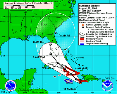
Here is the current forecast track for Hurricane Ernesto. Hurricane warnings are in effect for SW Haiti, where the rain will be the main problem. Rainfall will range from 6-12 inches here with isolated amounts in excess of 20 inches, especially in the mountains where there WILL be mudslides and unfortunately a huge death toll. From here it will slam into southern Cuba, into the mountains, which will hurt Ernesto greatly and may be our saving grace and prevent Ernesto making it to mainland US as a Major Hurricane. Then all eyes will shift towards the western coast of Florida as areas devastated by Hurricane Charlie in 2004, may be in the path of destruction again. Could this be "The One" for Tampa? Only time will tell.
No comments:
Post a Comment