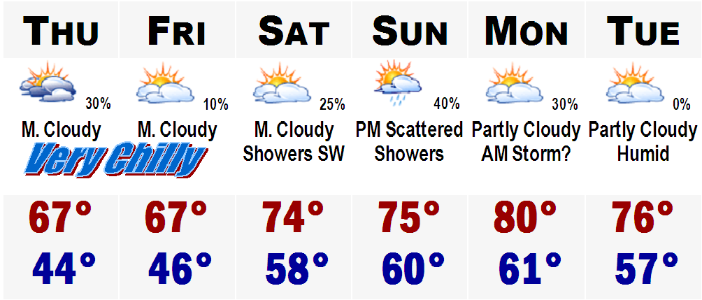
 An late September to early October chill is on the way for this last full week of August 2006. Thursday and Friday will be very cool with temperatures in the mid 60's along the coast with a strong marine influence to around 70 very far inland past Worcester. Temperatures overnight Wednesday and Thursday will likely drop into the 40's.
 Temperatures will start to rebound on Saturday into the 70's with a warm front trying to move in from the SW, but it will have a hard time getting up this far NE as High Pressure over southeast Canada will likely keep it at bay for a little while anyway. This will yield to a cooler weekend then previously thought and Sunday will remain pretty chilly, for this time of year with temperatures in the lower to middle 70's, coolest along the coast and Cape. SW winds will invade the area Monday and temperatures will respond to the passage of the warm front on Monday after a few Sunday night and early Monday morning showers and thundershowers as the warm airmass invades. Right now I am forecasting the temperatures for Monday afternoon to be around 80, possibly lower 80's, because of an extended period of cloudcover in the morning hours. The roller coaster ride will continue on Tuesday as a cool front will likely move back into our area from the NNW, with another fresh airmass from Quebec. High temperatures on Tuesday will drop back into the seasonable mid 70's.
All of this overnight chill the past few nights around SNE has caused some early fall colors in some of our regions weaker maples. This is actually very interesting to see. Very early to see as much fall colors in many trees this early in the season. Could it be a warning sign of a troubling and snowy winter in the months ahead? Too soon to know, but many meteorologists believe that this particular winter upcoming could be very similar to the winters of 1995-1996 and the snowy winter with the SNE Pre-Valentine's Day Blizzard of 2005, which was winter 2004-2005. Boston's International Airport saw 107" of snow and 86" of snow those snowy winters respectively.
Now back to the tropics. TROPICAL DEPRESSION 4 is still looking good around the Cape Verde Islands of Africa. It will likely reach Tropical Storm status soon, but will likely have a tough time of it to survive once it reaches the middle Atlantic. Could be trouble if it stays far enough south away from the high sheer northward and dry dusty air from the Sahara. Unlikely at this point as current forecast projections take it pretty far north and keep it at T.S. status and have it possibly dissapated later in the timeframe, maybe 4-6 days out. However, it will be something that we will need to monitor in the days ahead for any changes, but even if it does become very well organized, it still poses no imminent threat to any landmass or the United States.
More on the forecast and the possible formation of Debby in posts ahead.
No comments:
Post a Comment