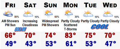
Can you believe it? This upcoming weekend is the weekend before the Labor Day holiday, an infamous one for many New England kids as it signals the last weekend of summer vacation and back to school. Well, it will sure feel like fall. Today, Thursday is very chilly, especially by the water, Boston, with temperatures struggling to reach 70 by early afternoon and before the rain tonight. Rain tonight? Yup, rain is moving in from the west as we are talking from NY State and is poised to move in later this afternoon and yield way to a rainy and showery cool overnight. Temperatures tonight with the rainfall will generally be around 50 in Boston metrowest to around 58 in urban heat islands like Boston.
The rain will taper very early Friday morning in the predawn hours, but the clouds will be slow to break for the afternoon, however they will eventually later in the afternoon around 3-6PM. Temperatures Friday will be exceptionally cold as there will be limited sunshine. Highs in the middle 60's will be found on the coast to around 69-71 inland by about 10-15 miles with a raw NE wind. A real preview of fall weather.
Saturday morning will be mighty cold for even our New England standards of August. Temperatures could bottom out to around 40 in Boston's metrowest suburbs of Bedford and Norwood. Early forecasts show that even Plymouth and Martha's Vineyard could bottom out around 42-46 degrees Saturday morning. Closer to the cities, temperatures will range from the upper 40's to around 50 just outside the city by about 3-4 miles, encompassing cities like Somerville, MA and Medford, MA. In the city itself, temperatures will range in the 53-56 degrees. In northern New England temperatures on Saturday morning will likely cause the National Weather Service to issue more Frost Advisories and possibly Freeze Warnings as temperatures will drop into the 30's in much of northern Vermont, New Hampshire, and Maine. Places like Sutton, VT and Berlin, NH could bottom out around 32-35 degrees. Mount Washington may bottom out into the middle to upper 20's with a biting winter wind, making it feel more like the TEENS! Now this is crazy summer weather. A few SNOW flurries is also possible on Mt. Washington during this cool spell.
Sunday will be a transition day before summer weather returns Monday with highs back into the 80's. Some places may see a 40-45 degree spike from Saturday morning to Monday afternoon. Now that is a shock to the system. But don't worry about it if you like fall weather, as I do. A cool front moves in from the northwest Monday night and cools us back down to late September coolness for much of the rest of next week. Lows back in the 40's for Wednesday morning in the usual cool towns of SNE.
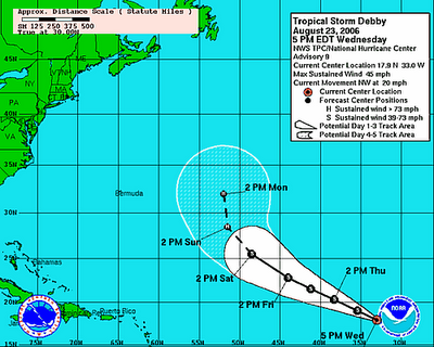
Forget about this one. At least put it way back into the back of your mind. Only interest for this storm will be shipping interests. Debby is going to get caught into the winds of a sprawling high pressure and move NNW and then take a dramatic turn to the north then likely NE as it hits a brick wall, the JET STREAM. Our saving grace. It will push Debby, whatever she may be at this time and send it to the "Hurricane Graveyard," the North Atlantic. It will move up there and soon become engaged into the jet stream and quickly become extratropical and turn into a regular storm losing all of its tropical charateristics.
There may be something developing around and just to the east of the Windward Islands at this time, but tropical cyclone formation is not likely to occur in the next 24 to 36 hours. It is something we will have to watch, however, as we are quickly approaching the climatalogical "peak" of hurricane season which tends to fall on the 10th or 11th of September.
Other than a few raindrops, enjoy the fallish weekend.
No comments:
Post a Comment