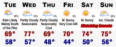
 After a washout Sunday with 1-2" of rain Monday has turned out to be "nice." At least its not raining. Its very cloudy with some peaks of sunshine, but it will be mainly cloudy all day today and it will be another cool one with temperatures staying in the upper 60's throughout SNE.
Rain moves back in tomorrow, anytime after the morning rush hour. Rain will become moderate to heavy by noontime, especially south of the Mass Pike, where rainfall amounts may top 1-2". A few localized areas in NE CT may pick up closer to 3" of rain. North of the Mass Pike, rainfall amounts will quickly drop off. Generally expect less than three quarters of an inch. Southern NH may struggle to even see a quarter inch. That will move out tomorrow night and yield a actually nice Wednesday.
Wednesday highs will get into the mid and upper 70's. A few towns like Taunton, MA may even come close to 80 degrees. Wednesday's warmth will be short lived. A cold front will move down through the area and Thursday will be much much cooler with highs possibly staying in the upper 60's to around 70 despite the unlimited sunshine. Lows overnight Thursday and Fridaymorning will likely fall into the mid 40's in the suburbs and Thursday's highs will probably just reach the 70 degree mark. Friday will likely struggle to reach 70 degrees again. It will really start to feel like fall here in Boston.
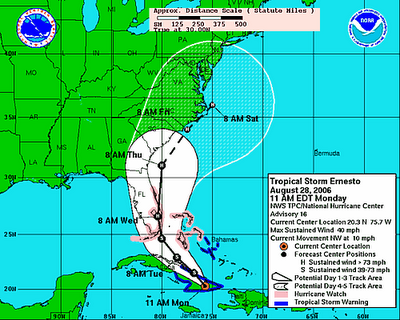 It is still summer though and the temperatures will respond this weekend after a couple very chilly New England mornings to end the week. This Labor Day weekend temperatures will likely get into the mid 70's. At this time, all eyes will have to be pointed south as current forecast projections now show Ernesto may be coming up the eastern seaboard and actually stall off the North Carolina coast and wander around there. Right at this time, it could be at hurriane status, likely a Category 1. This will be something we will have to watch very closely, but it is so far out that we cannot be sure of anything. Hurricane forecasts over 36 hours are nothing more than a flip of a coin.
Look at that chart above. Sea surface temperatures in the western Atlantic along the eastern seaboard are very warm at this time. Right now Ernesto is a minimal tropical storm with winds of 40 mph. It is forecasted to strengthen once it leaves Cuba, where it may even get downgraded to a tropical depression. Current models are showing that the storm will go between the Keys and Bahamas in the Florida Straights and hit southernmost mainland Florida, likely Homestead or Miami as a strong tropical storm with sustained winds up to 70 mph. After passing southern Florida it will move off the eastern Florida coast into the southern Atlantic. Now is where the sea surface temperatures come into effect. 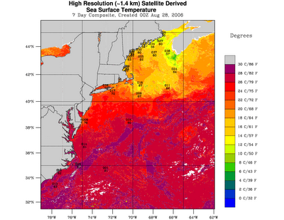
There is a large area of the Gulf Stream just off the coast that travels from Florida to south of Nantucket. Here we find water temperatures greater than 80 degrees. In the purple area that is where temperatures are in the 82 to 86 degree range. This will be fuel for Ernesto and if he is out over the open warm waters here he will likely strengthen and strengthen fast. Once it gets just off the Outer Banks, we will have to watch Ernesto's movements up here in Boston. More later.
No comments:
Post a Comment