 What an amazing satellite picture of this storm. I found that the lowest pressure of this storm system was at 968mb. To give you some perspective, that is a the general pressure of a Category 1 Hurricane. And in fact, some places did see hurricane force winds. The highest SNE wind gust that I could find was 80 mph and that was on Blue Hill. Many other areas, even inland areas, saw wind gusts between 55 and 65 mph. The storm began with a quick dump of snow in western MA which totaled up to 8" in Cheshire County and even northwest Middlesex county saw up to 2" of snow. Then it was the rains. Rainfall totaled between 3-5"+ and more is possible through Thursday as this storm will just sit and spin south of SNE through the period until it decays and moves out. In fact, tomorrow colder air will loop in as the storm sits off the Cape and we will likely see a rain/snow mix even down to the coastal plain. Don't expect any accumulation, but it will be nasty. The worst of the storm is over however. The good news is that springtime weather is only a week away and I will have those "warm" details out within the hour.
Monday, April 16, 2007
An Amazing Storm
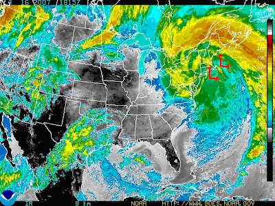
 What an amazing satellite picture of this storm. I found that the lowest pressure of this storm system was at 968mb. To give you some perspective, that is a the general pressure of a Category 1 Hurricane. And in fact, some places did see hurricane force winds. The highest SNE wind gust that I could find was 80 mph and that was on Blue Hill. Many other areas, even inland areas, saw wind gusts between 55 and 65 mph. The storm began with a quick dump of snow in western MA which totaled up to 8" in Cheshire County and even northwest Middlesex county saw up to 2" of snow. Then it was the rains. Rainfall totaled between 3-5"+ and more is possible through Thursday as this storm will just sit and spin south of SNE through the period until it decays and moves out. In fact, tomorrow colder air will loop in as the storm sits off the Cape and we will likely see a rain/snow mix even down to the coastal plain. Don't expect any accumulation, but it will be nasty. The worst of the storm is over however. The good news is that springtime weather is only a week away and I will have those "warm" details out within the hour.
Subscribe to:
Post Comments (Atom)
No comments:
Post a Comment