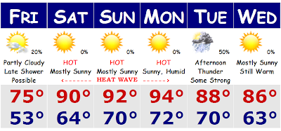
 After the past couple of days with highs in the upper 50's to low 60's with persistent drizzle and light rain on a northeast wind, we are finally going to see the sun again and warmer temperatures. It will be a gradual step up for tomorrow with a return to the sun and temperatures back up to seasonable levels, mainly the low 70's along the shore and mid 70's inland. There is still the chance of a scattered shower here tomorrow, but they will be few and far between. Tomorrow will be a day where you will likely wake up to a few morning clouds and then have mainly cloudy skies in the afternoon as a warm front will try to move through the area later tomorrow evening and overnight. That is when we could see a few scattered showers and thunderstorms, but warm fronts do not usually have severe weather associated with them in our area due to the marine influence and the fact that we are going from marine air to warmer air. To get the big thunderstorms all the way to the coast we need extreme heat and humidity and a massive cold front coming from the WNW to get us with our big boomers. The ocean usually saves us from seeing the big storms like we see in the Midwest.
The heat wave starts on Saturday as we will get into the low 90's just away from the coast, probably mid-upper 80's for Boston and the immediate shore. We will all go into the low-mid 90's on Sunday and Monday even to the coast and the humidity will come way up as well. Early indications suggest that we could see dewpoints come up between 65-70+. That could push heat indices all the way to 100 degrees by Monday. Showers and thunderstorms will bring the less humid, yet still warm conditions for Tuesday and Wednesday.
No comments:
Post a Comment