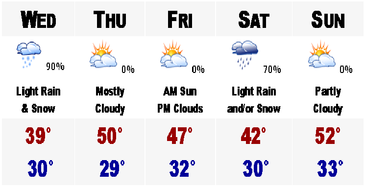
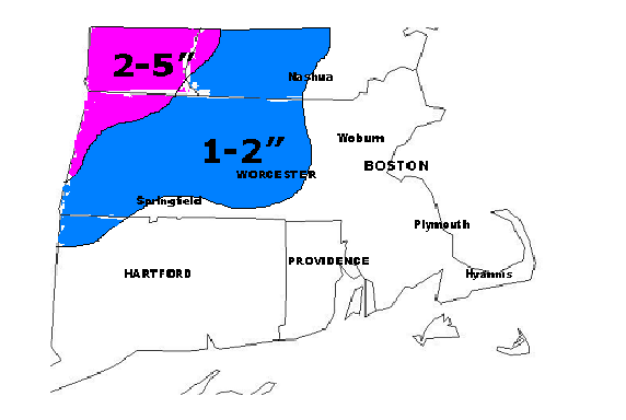
Snow Adviories and Winter Storm Warnings are posted for much of central and northern New England this evening for some heavy amounts of spring snow. Parts of the Green Mountains of Vermont and the White Mountains of New Hampshire could wind up with 8-12" of snow, highest amounts in the highest of elevations. In lower elevations of northern New England, anywhere from 3-6" is expected. Even in NW Massachusetts, 1-3" is in the forecast with an inch or two in Worcester County. Closer to us, in Boston metro, the lawns and grassy surfaces may get a thick coating of snow. Its around 8 PM here in Woburn and already the temperature has dropped to 36 with a mix of rain and wet snow flakes. Tomorrow will begin with the snow, heaviest and steadiest in the morning and any accumulations will most likely occur at this time. It should be just a plain snow for everyone north and west of Quincy, about. Highest elevations have the best chance of seeing a couple inches accumulate on the ground.
Thursday will bring back the sun and with that we will rebound temperatures into the lower 50's. However, Friday may feature a bit more inclement weather than advertised on the 5 DAY. There may actually be scattered rain showers in the area with cool highs only in the mid to upper 40's. Saturday morning may be a repeat of tomorrow morning with morning snows, accumulations are possible at this point in the highest of elevations once again. This is something we will have to watch closely. Thereafter, temperatures will rebound as a pattern change will take place and temperatures should be back into the 60's by midweek, next week. Enjoy winter's last gasp.
No comments:
Post a Comment