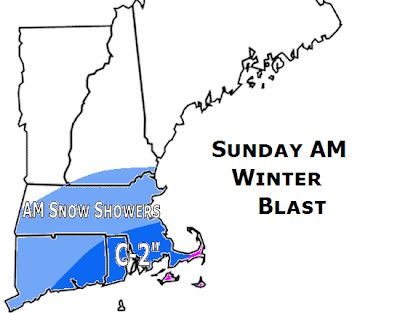
 FINAL CALL 3/15 @ 4PM: The "on again, off again" storm is partially on again. We will by no means see a direct hit, as the storm will go well south of the area, but will throw some snow/rain into the southeastern part of the region. Here to the right is the worst case, snowiest scenario and its not that snowy. Worst case scenario is that we see some morning snow showers in the Boston metro and Worcester metro areas that could make it up to Nashua, NH. You will need to travel south of Brockton to see some snow accumulate. We will see coatings of snow that melt away once it stops, quite common in the darker blue region, but in the absolute worst case scenario, up to 1-2" of snow, wet gloppy snow (mashed potatoes) could accumulate. This region includes Providence, Warwick, Attleboro, Taunton, Plymouth, and down to the Bourne Bridge. Boston and northwest will be lucky to see a trace to a skim coating on the grass. It will be a borderline situation as temperatures will generally be in the 33-36 degree range for the duration, so getting this to accumulate on the roads will be all but impossible. That is all for now.
Saturday, March 15, 2008
"Grazed"
 FINAL CALL 3/15 @ 4PM: The "on again, off again" storm is partially on again. We will by no means see a direct hit, as the storm will go well south of the area, but will throw some snow/rain into the southeastern part of the region. Here to the right is the worst case, snowiest scenario and its not that snowy. Worst case scenario is that we see some morning snow showers in the Boston metro and Worcester metro areas that could make it up to Nashua, NH. You will need to travel south of Brockton to see some snow accumulate. We will see coatings of snow that melt away once it stops, quite common in the darker blue region, but in the absolute worst case scenario, up to 1-2" of snow, wet gloppy snow (mashed potatoes) could accumulate. This region includes Providence, Warwick, Attleboro, Taunton, Plymouth, and down to the Bourne Bridge. Boston and northwest will be lucky to see a trace to a skim coating on the grass. It will be a borderline situation as temperatures will generally be in the 33-36 degree range for the duration, so getting this to accumulate on the roads will be all but impossible. That is all for now.
Subscribe to:
Post Comments (Atom)
No comments:
Post a Comment