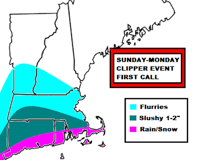
 This clipper system has been on and off for the past week. Early in the week, it looked like we would be getting something from this. Then the signal died. It died to the point where it was barely on the maps anymore. Now the GFS is back on the bandwagon and giving parts of southern New England heavy duty precipitation. However, the NAM, another reliable model is very dry. So if we break it down between the two most reliable models....
The GFS brings the 0.25"-0.50" of liquid to southern Vermont and New Hampshire. This would be mainly snow, so you can imagine that someone or many would see a general 3-5" snowstorm out of this, with rain along the Cape and immediate coastline, Boston being right on the line between rain and snow. It paints QPF up to 1"+ in parts of Connecticutt, so we could see 4"+ there. However the NAM barely brings any rain/snow light showers onto the South Coast with most of the precipitation missing SNE by 100-200 miles. Most of the precipitation would fall over PA and NJ. New York City could see its first flakes.
You can see that the models are AWFUL this season. They cannot even come into some kind of agreement only 24-36 hours before the event. This is a shot in the dark forecast for any meteorologist. If they side with one, they could bust badly, and even if they go in the middle, like me, they could still bust badly. If you call for a the first flakes, even if its a few flurries and it doesn't happen...its a bust. If you call for a few flurries and you get 5" of snow...its a mega BUST.
Basically, this forecast has BUST all over it. I know I will have to change this forecast, but this map is what my first call is. The South Coast will see a mix of rain and snow, mainly rain. Up to .25-.50" of QPF. Further north, where it will be colder, a sloppy 1-2" of snow will fall, highest in the highest elevations in NW Rhode Island and northeastern Connecticutt. Southern Worcester county could see a whitening of the ground as well. Then north of the Pike, expect flurries all the way to southern New Hampshire.
Thats my call for now. If we see the NAM come further north, these snowfall amounts will come up. If they side more with the NAM, don't expect much tomorrow. Timing on all this is delayed now. Mainly late Sunday afternoon through the overnight hours of Sunday. A delay of about 24 hours.
No comments:
Post a Comment