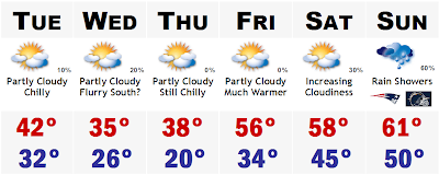
 What a nice little January SNE rainstorm we had today. Rain pretty much from sunup to sundown. Rain was pretty heavy and soaking around two this afternoon. Most areas picked up between 0.75" to 1.5" of liquid today, except areas in the North, especially northern NH and Maine. In NH, northern areas picked up between 2-5" of slushy wet snow before transitioning to sleet and then rain. Areas in northern Maine got their snowstorm and wound up with a mostly all snow situation, with upwards of 6-8" of snow, heavy wet snow at that. That storm is ancient history now and we are looking forward. We are looking forward to colder air tomorrow. Tomorrow will still be above average, but not as much. We will see highs generally in the lower 40's, with ample sunshine, developing clouds late afternoon. There could be a widely scattered flurry, especially south of the Pike overnight Tuesday and Wednesday morning, but that we be just about it. That leads us into a decent Thursday with highs in the upper 30's to around 40, after morning lows in the upper 10's and low 20's. Crazy that Boston has yet to go below 32 this entire month. Thats over 200 hours of above freezing temperatures in the city of Boston. Amazing. The warmth surges back again on Fri
 day with highs likely back into the mid 50's once again and even warmer on Saturday. Highs could easily top out in the upper 50's Saturday and Sunday, ahead of a strong Arctic, pattern changing, cold front, we may see temperatures soar to near record levels once again. Low 60's? A possiblility. Then as the graphic from Accuweather shows, we will be transitioning into a much colder, blocked pattern across the eastern 2/3 of the lower 48. This will be a pattern more condusive for sustained cold and more snow chances. There are signs now that the NAO could be dropping to near neutral by the middle of next week. Keep in mind that we usually get our biggest snowstorms when the NAO is nearing neutral. Ie the President's Day Blizzard of 2003 that dropped 27"+ to Logan and a widespread 18-24" to the entire megalopolis, from DC to Boston. Something to keep an eye on at least.
After Sunday's possible incredible warmth part II, I see Monday being a transition day with colder, much colder air blasting in from the WNW. I see Monday with highs likely in the mid-upper 30's, but in a few days, you will likely start to see some real cold entering the six day forecast. I am talking highs likely staying in the 20's and lows easily in the 10's and perhaps some 0's in the colder valleys for overnight temperatures. Ie, Norwood, Bedford, Taunton. Watch out.
2 comments:
Wow...61 by Sunday? Thats amazing.
Any snow next week?
Post a Comment