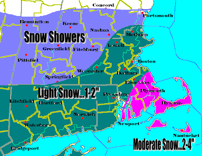
 Okay. This snowfall map has absolutely nothing to do with the Thursday night-Friday storm that will be affecting SNE. This is totally independent. It is forecasted for tomorrow night through Wednesday morning. What looked like a dying clipper system moving into our area, now looks like it will hit the water and be revived. This revival will occur very quickly and there will be a pretty decent shot of Atlantic moisture being tossed into this system and many areas could be picking up a fairly healthy surprise snowfall out of this one. It looks like the heaviest snowfall will occur in SE Mass and the Cape, as they will be closer to the quickly developing storm. Snows of 2-4" are likely there, after many areas picking up 1-3.5" of snow with ocean effect this morning. Otherwise a solid 1-2", isolated areas of 3" are possible for the rest of eastern SNE. This is a developing situation and will be outlining the effects of this surprise storm and the storm that will be a possible Kahuna for SNE later in the week.
Monday, January 29, 2007
A LITTLE SURPRISE
 Okay. This snowfall map has absolutely nothing to do with the Thursday night-Friday storm that will be affecting SNE. This is totally independent. It is forecasted for tomorrow night through Wednesday morning. What looked like a dying clipper system moving into our area, now looks like it will hit the water and be revived. This revival will occur very quickly and there will be a pretty decent shot of Atlantic moisture being tossed into this system and many areas could be picking up a fairly healthy surprise snowfall out of this one. It looks like the heaviest snowfall will occur in SE Mass and the Cape, as they will be closer to the quickly developing storm. Snows of 2-4" are likely there, after many areas picking up 1-3.5" of snow with ocean effect this morning. Otherwise a solid 1-2", isolated areas of 3" are possible for the rest of eastern SNE. This is a developing situation and will be outlining the effects of this surprise storm and the storm that will be a possible Kahuna for SNE later in the week.
Subscribe to:
Post Comments (Atom)
No comments:
Post a Comment