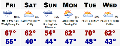
Rain is in the forecast for Friday morning. Rain will move into the area from west to east around 3-4AM west of Worcester to the beginning of the morning commute around Boston and Providence. The rain will be short lived, lasting only 4-6 hours, but will be accompanied with strong gusty winds from the southeast before the front moves through, gusting to around 40mph. Winds could gust over 60mph on the western slopes of the Green Mountains. Winds will shift from the SW after the front, warming us up to around 70 in the afternoon and then shifting to the NW overnight Friday.
Saturday will be cool and Sunday more rain is in the forecast for the late afternoon. The Red Sox could have trouble getting in their last game of the season this year, as rain should start around gametime. Temperatures will struggle to warm into the mid 50's Sunday. Figures, becuause I have tickets to it.
Fall foliage is really starting to come on strong with much of northern Vermont, New Hampshire, and Maine reporting peak conditions THIS WEEKEND! Next weekend, it will be too late for these regions. Expect peak conditions next weekend all the way down to Conway, NH and perhaps just NW of Portland, ME and just north of Concord, NH. It will continue to tumble south during the next four weeks. In four weeks, the color wave will be likely pushing off the south coast of New England and we will be getting ready for winter.
More later.
Side note...T.S. Isaac has formed with winds of 40mph in the central Atlantic and is, you guessed it, going out into the graveyard of the North Atlantic. Maybe some larger surf by the end of the weekend.
No comments:
Post a Comment