 Labor Day weekend is over. It is the "unofficial" start to autumn. It was a pretty good summer weatherwise, but timing of the bad weather was everything. We only had 5 totally dry weekends out of 14. We were right about average with Eleven 90 degree days, the average is 12 for Boston. We also went through 2 heat waves. Plenty of rain, as all of our lawns are still green.
For the Back to school forecast, more rain is on its way. Many schools go back tomorrow the 5th, and they will be greeted with temperatures in the upper 50's at the bus stop. Here is the School Bell Forecast.
BACK TO SCHOOL FORECAST
BUS STOP...Partly Cloudy/Chilly 57
RECESS 10AM...Increasing Cloudiness 66
LUNCH...Partly Sunny 69
LAST BELL...Mostly Cloudy 71
PRACTICES...Overcast 68
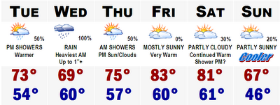
Rain will move in after dinnertime tomorrow night and become steadiest overnight Tuesday and into the morning hours of Wednesday. Wednesday will be pretty much a complete washout with about an inch of liquid. Thursday will clear out and temperatures will respond later next week with temperatures into the lower 80's by Friday and Saturday. A major cold front will move through the area later Saturday night and highs on Sunday will likely stay in the 60's with lows dropping into the lower to mid 40's in suburbia.
TROPICAL DEPRESSION 6 UPDATE

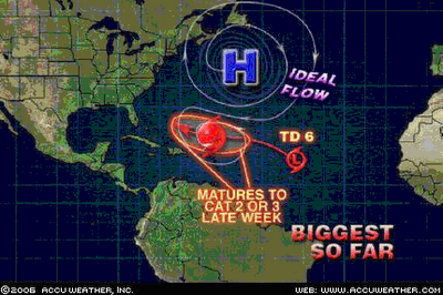
Tropical Depression 6 is still alive tonight, but hasn't changed much from last night's update. Winds are still at 35 mph. Right now it is encountering lots of sheer from a decaying cold front that moved through our area before. It is just about to move away from that sheer enviornment and once it does it will start to strengthen dramatically. It could become Tropical Storm Florence by tomorrow afternoon. This thing will move slowly towards the eastern seaboard and gather strength all the while. Current projections show this storm reach Category 2 or 3 status by sometime this weekend. It is still a long ways out so all I can say at this time is to keep this potential threat in the back of your mind. This will not become a major story until later this weekend, if it holds together.
More later.
No comments:
Post a Comment