 Sorry I have not been able to post for the past couple of days. School has really started full gear this week and promises to be much of the same until winter break, at least. Tonight will be a quick post, but after last night's 32 degree night in Norwood, MA and today's 35 degree low there, there is good news. I don't see that type of cold until a long time from now. Maybe for the next 10 days.
 Hurricane Florence hit Bermuda with peak wind gusts there around 100 mph, with minimal damage to property. Now that storm system is quickly becoming extra-tropical over Newfoundland. Now there is Hurricane Gordon, with max winds of 110 mph. It has developed a rather impressive eye. This is something you have got to see on the satellites. TD 8 is by the Cape Verde Islands and is expected to become Helene within the next 24 hours. Very busy, but all look to be staying well out at sea, not affecting anyone, but the fish.
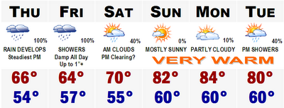
A quick look at the five day and you will see rain will be developing tomorrow, especially after noontime. Rain could come down at a moderate clip tomorrow night and continue off and on through Friday and possibly Saturday morning. Generally, most areas will pick up anywhere between 1-2" of rainfall.
That will clear out late Saturday afternoon and then Mother Nature turns up her heat furnace, something we have had to do the past few nights where I live, anyway. Temperatures by Sunday, Monday, and Tuesday could be in the 80's. This will be our mini-Indian summer for some, Norwood and all of Northern New England as they have already seen their first frosts and freezes. However, the warmth will leave with a few showers Tuesday and by the end of next week, there are signs that everywhere east of the Rockies could be shivering once again. I won't get ahead of myself, but we'll definitely be breaking out the shorts and flip flops for the end of this weekend and early next week here in Boston.
No comments:
Post a Comment