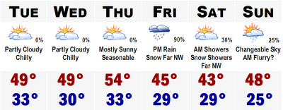
 Colder than usual times are ahead this upcoming week. Tomorrow will be cool with highs in the upper 40's to around 50. The same can be said for Wednesday and with more sunshine on Thursday, highs could rebound back into the low-mid 50's, more seasonable for late October.
 As this is going on, a storm system will be moving in on us from the southwest. It should cut to around Pittsburgh, PA, bringing in a shield of rain with snow mixed in on the northernmost edge into the mountains of northern New England. A secondary low will form off of Cape Cod, bringing in cold air into the storm even more and this could yield to accumulating snows for much of northern New England. Still to early to speculate, but some areas, especially elevations higher than 1600' could see in excess of six inches of snowfall.
Southern New Hampshire and Vermont could even see some snow mixed in with the rain Friday night. The Worcester Hills could see a few flakes as well. It all depends on how hard the precipitation falls. If it falls heavily enough, it could bring cold air down from the storm, turning the rain over to snow. Needless to say, it could get interesting around here on Friday. Thereafter, expect chilly conditions and on Sunday, we could see a few passing flurries, even down to the coastal plain with highs in the mid 40's.
More on the forecast later...and on a side note...the tropics are gurgling in the Pacific. Hurricane Paul now has winds of 90 mph and Baja California is currently under a Hurricane Watch and will likely bear the brunt of Hurricane Paul. Tropics in the Atlantic continue to be absolutely quiet.
No comments:
Post a Comment