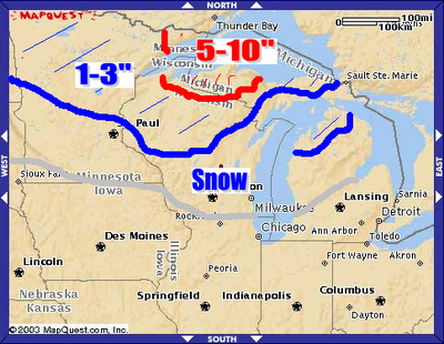
 Here are the preliminary numbers for the snowstorm this week, tomorrow night into most of Wednesday. The UP of Michigan is already under a Winter Storm Watch at the current time. Many spots here will see substantial accumulations, likely over 6". Some higher elevations, inland, could see upwards of 12-15" of snow, believe it or not. Power outages, lines down, and nearly impossible driving conditions are likely here. Most of Minnesota and Wisconsin will just see a meager amount of 1-3" of wet snow. Snow will likely not stick to the roads, but could stick to the trees and power lines and with most of the trees still with their leaves, there may be a few isolated power outages.
 In the gray shaded area, expect to see some snow in the air, but it will likely not stick. Just a sign of things to come. There could be a few snowflakes flying all the way down in Chicago later this week, Wednesday. That storm will funnel in our cold air for late week. There may actually be some snow in the Berkshires and Green Mountains on Friday morning. We are not talking about a snowstorm, but there could be some Snow Showers out there with a possible coating of snow in the high elevations and mountains.

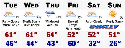
The 80 of today is long gone. Highs will stay in the 60's through Thursday and Friday morning and then with the passage of the cold front associated with the massive midwest snowstorm, temperatures will nosedive Friday afternoon through the 50's and probably hover in the upper 40's all afternoon. Highs in the lower 50's are likely Saturday and Sunday with a HARD KILLING FREEZE likely both nights. No escaping it this time, except if you live in the city of Boston.
Lows Sunday morning will likely be in the 20's throughout much of the suburbs, and up in the cold spot of New England, Berlin, NH, lows could bottom out in the mid teens with great radiational cooling. I'll be in New York this weekend...so I'll be posting for the rest of the week and then probably take the weekend off.
More later.
No comments:
Post a Comment