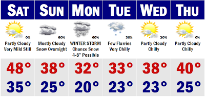
 Finally the models are starting to come to some sort of agreement this afternoon. It is looking more and more likely that we will have a winter storm here for New England on Monday, Sunday night into Monday, ending sometime Monday afternoon. It looks at this time to be a moderate snowstorm. If I had to put some numbers to my thinking right now, I would say a regionwide 4-8" is possible, with less on the Cape, but its so early they have just as much of a chance as Boston to see upwards of a half foot of snow. The computer model that I trust a lot at this timeframe is the GFS and SREF's. They are usually very good and are showing a dumping for our area. Still way too early to peg numbers, probably will wait until a couple hours before the Pats game to put out my first forecast on snow amounts. It should be a regular Nor'easter, with gusty NE winds, may cause coastal flooding, but astronomical high tides will be low-moderate as it will be a half moon. Still too early to peg details with this storm just yet as placement of the LP is still too hard to peg ATTM.
To get there, tomorrow will be a warm day before we return to reality on Monday with lots of shoveling. It will be semi-cold next week and maybe we will get back to 40 degrees by Thursday, but by the end of next week, the other shoe will drop and we will be back in the 20's for highs.
 Patriots Forecast
8:00PM Kickoff
Patriots (16-0) v. Jaguars (11-5)
Kickoff: Mostly Clear, Light Winds; 38
Halftime: Mostly Clear, Light Winds; 35
Final Seconds: Mostly Clear, Light Winds; 32
_____________________________________________________________
That's all for now. I will have more on the potential winter storm later this weekend. Have a nice weekend and GO PATS!
No comments:
Post a Comment