Friday, August 31, 2007

A Perfect Labor Day Weekend

The dry weather will continue onward through the upcoming weekend and early to the middle part of next week. Long range forecasts do bring some rain around here by the end of next week towards next weekend. Thats a long way out.

First we start the weekend off perfect and never look back. The front is moving offshore right now and will be long gone by tomorrow and will bring in a new round of fresh air, with temperatures in the mid 70's. This cooler air will not last for long. We start to warm up all over again on Sunday with temperatures getting back into the 80's once again. Monday, Labor Day, will feel more like the 4th of July with highs getting into the lower 90's away from the coasts. It will be hot and somewhat humid, but not oppressively so.

We cool a tad for Tuesday before more sunny perfect weather follows for the first week of school for many in the Boston area. Also, important to note that the tropics are starting to heat up once again with six areas of concern outlined by the NHC. There is one low pressure system located just east of the Lesser Antilles and is nearing tropical depression status. It would look like this storm could become Felix, but then it would move pretty much over the same waters that Cat 5 Hurricane Dean did, which took a lot of the heat energy away from the water. We'll see how it develops.

Enjoy the last day of August, September is almost here.

Thursday, August 30, 2007

Beginning of a Drought; No Relief in Site

This forecast is great for late summer vacationers, but it is not great for our lawns, plants, and gardens. This is really starting to get serious and towns are running out of water, imposing water bans. Currently, there are 32 towns in the Commonwealth that are imposing some type of water ban, limiting outdoor water use. A little relief is possible tonight with some whaning thunerstorms moving down from northern New England, but that will exactly be it, whaning thunderstorms. Actually, some towns won't even get a drop of rain out of this frontal system. It may bring in a few clouds overnight and early Friday, but those will likely break in the late morning and afternoon, yielding a beautiful day. Then its nice and sunny, southern California weather through the next 7-10 days.
This is a map from the U.S. Drought Monitor and is now showing southern New England in some type of drought, the beginnings of a drought and it looks like it will get more severe as time goes on without any type of rainfall.
We are in the first shading, the color yellow. Yellow stands for D-0, which means that it has been and is abnormally dry. This outlook comes out once a week and we will likely see more of southern and even central New England in the yellow shading, and some parts of southern New England may pass into D-1, a moderate drought. The top layer of soil is really getting baked out as we have nearly 100 percent sunshine days which really evaporates any water on the surface of the soil. That is why many of your lawns are starting to turn brown and crusty. Also, this is partially why that some trees have decided to lose leaves early and turn prematurely as well. It will likely be a poor year for fall foliage this year with early leaf loss inhibiting nice color and the color that does develop in October will likely be dimmed a bit because of early changing. We'll see.

Tuesday, August 28, 2007

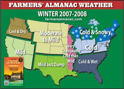
Farmer's Almanac Predicts a Snowy, Cold, Wild Winter

The Farmer's Almanac has published its 2007-2008 Winter Outlook for the United States and Canada. The publication came out yesterday and is calling for a cold, wild winter east of the Mississippi River.

More bluntly, expect more snow and cold than normal here in New England, much of the Northeast and Great Lakes. Expect cold conditions in the Mid Atlantic with above normal snowfall and cold conditions relative to normal in the southeastern United States. The West will be more mild overall, but even in the northern and central Plains where they are calling for moderate to mild, there will certainly still be outbreaks of Arctic cold and heavy duty snows no doubt. Overall, they think that it will be milder than normal for much of the country west of the mighty Mississippi.
The normal snowfall in any given winter for the city of Boston is around 42" with annual snowfall rapidly increasing as you head out of the city by 5-10 miles, getting up to around 50-60" rather quickly especially west and northwest of the city. Average snowfall, as you can see from the map to the right, (courtesty of Eastern Weather Forums member) average annual snowfall quickly increases to 60-70" out past Bedford, through western Middlesex, Worcester County, and northeastern CT and NW RI.
This map is a very good representation of what kind of snowfall you can expect in any given winter here in SNE. Last winter was not a good winter for snow as Boston came in with generally under 20" and where I live, we only picked up 30-32" of snowfall the entire year, not bad considering that we stood at 2-3" for half of the winter season before the Valentine's Day mess, which I will always remember leaving Logan Airport at 10PM with a temperature of 27 degrees, freezing rain, and winds up to 40 mph out of the NE. It was a great vacation though. We made it off that night.
Farmer's Almanac is calling for above average snowfall, so those are your averages. Above average snowfall could be 43" or 87"as in 2004-2005. We just can't be sure on this and bet all our money that FA will be totally right. Last winter they called for above average snowfall and we ended up with less than half of what we normally receive. Its up to the weather gods. I just wanted to post this and let you decide for yourself.

Dry Pattern Persists

Our forecast is looking more and more dire as we progress through the period. Usually, I am all for nice sunny weather, but this is starting to get a little ridiculous. The next 6-10 days will feature very little in the way of rain and clouds for that matter. Our forecast is looking like something from Palermo, Sicily or southern California during their dry season. It leaves little for me to say, except for the temperatures. Today and tomorrow we start to turn up the heat a tad. Today, Tuesday will get into the lower to mid 80's, but tomorrow we will notch up the temperatures to the mid and upper 80's and notch them up again on Thursday ahead of a cold front, with temperatures approaching 90 before the threat of a widely scattered thundershower.

I got to tell you, this front does not look to pack much of a punch at all. If anything, thunderstorms will develop near the Canadian border in northern New York and Vermont and these showers and storms will slowly weaken and fall apart as they head southeast with the cold front, as usual. I would not bet on your lawn getting a good drink of water overnight Thursday. If you do, consider yourself lucky.

After that, we enter a long period of sunny dry days with temperatures seasonable, mid and upper 70's with overnights chilling off because of the low humidity. We will start to warm up all over again early next week. We may be pushing 90 by next Tuesday!

Monday, August 27, 2007

September Outlook

September is a great month for transition here in New England. We can get great summer days, that if you didn't know any better, you'd think it was mid July. But as the month moves along, those summery September days become few and far between. By the end of the month, towards October 1st, we will get scenes like this developing all over the great Northern New England, especially over the Green Mountains of northern Vermont, the White Mountains of northern New Hampshire and the mountains of Maine in the northwest portion of the state. Oddly, due to the drought and possibly the few cold nights we experienced last week, I have noticed more colors than usual for late August-early September here in SNE. There are many trees that have already changed to their peak colors, so early, which makes me wonder whether this will be a slow year for fall foliage in New England. If memory serves me right, I believe last year was a fairly good year.
Boston and its Suburbs Averages___________________________________
Boston...September 1st 77/62
Boston...September 30th 68/52
Boston's lowest temperature for September is 34 degrees, set on multiple occaisions. The highest September temperature for Boston is 102 degrees, set on September 7, 1881.

Nearby Suburbs...September 1st 77/55
Nearby Suburbs...September 30th 67/45

For Boston's nearby suburbs, I will use Bedford, MA for reference. Bedford's lowest temperature for September is 26 degrees, set on September 26, 1965. The highest temperature recorded is 95 degrees, set on multiple occaisions. ___________________________________________________________________

So, how is it going to be this September? I am not a big fan of long term forecasting because if I can barely get a five or six day forecast on key, then how in the heck am I going to be able to put out a month outlook. However, there are many resources out there for amateur forecasters like myself. This image is from the NWS Climate Predictions Center. (CPC) It is outlining much cooler than average temperatures for much of the nation east of the Rockies, with the greatest threat for cooler than average weather in the northern Plains through Kansas, Oklahoma, and Texas, extending the cooler than average air through the Ohio Valley and up towards the Northeastern US and New England. The Southeastern States are blocked from this with above normal temperatures which tells me a Southeast Ridge will be dominant there then next 1.5-2.5 weeks. Where there is cooler than average temperatures, especially in the southern part of the country, you can bet that there is going to be much higher than normal precipiation the next 8-14 days because that is the only way people down there can stay below normal for an extended period of time at this point in the year. The northern part of the country is becoming more prone to cold fronts from Canada that drop temperatures fairly significantly, and they will only become more and more common as the month of September progresses.
Rainfall, here in Southern New England, looks to be getting to around normal, thankfully, as many lawns, including my own are suffering from the extremely dry August we have endured. My front lawn is totally brown and dormant. September will relieve this with more rainfall and cooler days, and dew-y cool nights. There will be a rebirth in your yards by early-mid September before all plants start to get ready for the long winter months in early-mid October.
Enjoy the last days of August 2007, its been a great summer. Looking forward to the autumn and all it will bring.

Sunday, August 26, 2007

Saturday, August 25, 2007

Boston's 4th Heatwave of the Summer?

Today was one of the hottest days of the summer season. Temperatures in many communities got well into the mid and upper 90's. The magic number for many towns seemed to be 95 and 96 degrees. Boston came in this afternoon with a peak temperature of 95 degrees with a dewpoint in the low 70's, making it feel like 104 degrees at the worst today. Yesterday hit 91 degrees at Logan so we could set the table for a late August official heatwave in the city of Boston and many other towns, if we hit 90 degrees tomorrow, which I think we will be able to do. There will be a few clouds early on with showers exiting and then the clouds will break and we will get residual heat, making it back to between 87-91 degrees.

Overnight lows will be absolutely disgusting tonight with temperatures staying in the mid to upper 70's. Can't take it? Well then wait until Monday when temperatures will cool about 10 degrees and the humidity will be taken down a few notches. Highs should get into the low 80's, but it won't feel as hot. Then we set the table for a perfect couple of days, Tuesday and Wednesday. Highs should be in the mid 80's under mostly sunny skies. Its too bad many towns go back to school this week. The kids will be stuck inside watching the nice weather this week, because by the weekend, it looks like we could be getting into more of an unsettled pattern once again with cool temperatures.

Its the end of August and that means that our weather is starting to transition from one extreme to another. If you booked a beach vacation, you have to be weary about this towards the end of the summer because you can get hot days, like today, but you can also get stuck with a stretch of cool cloudy days like we saw the past several days. Less crowds, though. Pick your poison.

Heat Advisory this Afternoon

The NWS out of Taunton has issued a *Heat Advisory for much of Southern New England for this afternoon as heat indices will likely come up over 100 degrees. Here is the outline for the Advisory.

...HEAT ADVISORY NOW IN EFFECT FROM 1 PM THIS AFTERNOON TO 7 PMEDT THIS EVENING...THE HEAT ADVISORY IS NOW IN EFFECT FROM 1 PM THIS AFTERNOON TO 7 PMEDT THIS EVENING FOR THE BOSTON...HARTFORD PROVIDENCE METRO AREAS OFSOUTHERN NEW ENGLAND.

RECORD TYING HEAT WILL OVERSPREAD SOUTHERN NEW ENGLAND THIS AFTERNOONWITH HIGH TEMPERATURES CLIMBING INTO THE MID AND UPPER 90S ACROSS THECONNECTICUT RIVER VALLEY...THE PROVIDENCE TO BOSTON CORRIDOR AND THEMERRIMACK RIVER VALLEY OF SOUTHERN NEW HAMPSHIRE AND NORTHEASTMASSACHUSETTS.THIS INCLUDES THE CITIES OF...HARTFORD...SPRINGFIELD...MANCHESTER...NASHUA... LOWELL...LAWRENCE...GLOUCESTER...FOXBORO...NORWOOD...CAMBRIDGE...BOSTON... QUINCY...TAUNTON...BROCKTON...FOSTER...SMITHFIELD AND PROVIDENCE.

THERE IS A LOW PROBABILITY THAT THIS ADVISORY WILL NEED TO BE UPGRADEDTO AN EXCESSIVE HEAT WARNING FOR HARTFORD COUNTY CONNECTICUT AND THEREGION BETWEEN BOSTON AND NASHUA. IT IS HERE THAT HEAT INDICES MAYRISE BRIEFLY TO 105 DEGREES THIS AFTERNOON.THE ADVISORY DOES NOT INCLUDE THE SOUTH COAST OF NEW ENGLAND AS SLIGHTLYLOWER TEMPERATURES ARE EXPECTED.

NEVERTHELESS... THE COMBINATION OFNEAR RECORD HIGH TEMPERATURES AND HIGH HUMIDITY WILL INCREASE THECHANCES OF HEAT EXHAUSTION AND OR HEAT STROKE WITH ANY OUTDOORACTIVITIES THROUGHOUT SOUTHERN NEW ENGLAND THIS AFTERNOON.A HEAT ADVISORY IS ISSUED WHEN HIGH HUMIDITIES ARE EXPECTED TOCOMBINE WITH HOT TEMPERATURES RESULTING IN HEAT INDICES OF100 DEGREES OR GREATER. AVOID PROLONGED WORK IN THE SUN OR INPOORLY VENTILATED AREAS.

ALSO...DRINK PLENTY OF WATER AND TRY TOSTAY IN AN AIR CONDITIONED ENVIRONMENT.
___________________________________________________________________

Be smart today and do something that isn't strenuous on your body, if you can't, be sure to drink lots of water and sports drinks.

Thursday, August 23, 2007

Excessive Heat

The hottest weather of the summer season is coming to SNE. The highest temperature so far in Boston this summer is 96 degrees. Today is the last cool afternoon, but the humidity is moving in as we speak, even though temperatures are in the mid and upper 60's this afternoon. They will stay there all night as well and then we will see a nice jumpstart tomorrow morning with temperatures around 70, we will get near 90 degrees tomorrow afternoon with increased humidity.

Temperatures will really get HOT on Saturday with a SW wind sending in all the excessive heat that has been in the lower Ohio Valley, in the Southeast, and down South. Temperatures will likely be near record highs, the record for the date in Boston is 96 degrees. Boston will probably get to 97 degrees. Some spots will get near 100 degrees, believe it or not, after all this cool air. Sunday is nice, and Monday is cooler before we warm up again later next week.

Tuesday, August 21, 2007

A Return to Summer

If you have gotten tired of autumn in August here in SNE for the past several days with days struggling to get out of the 60's with lows down into the 40's on a nightly basis, you will like this forecast.

We are about to return to summer for at least a little while with temperatures getting back to more summerlike ranges. First, we have one more cool afternoon to get through, tomorrow, with highs in the upper 60's. We will start off really cool tomorrow morning as well with many towns in suburbia getting back into the 40's. Thursday will be a nice day with highs in the upper 70's, but clouds will tend to be on the increase in the afternoon, ahead of the warm and sultry air for Friday and especially Saturday.

The 80's return for Friday with a few showers around, summertime showers which are hit and miss and the same can be said for Saturday. Not all places will see a shower or thunderstorm, just a chance of seeing one at any given time in an unstable atmosphere. Temperatures get to near 90 on Saturday with dewpoints rising back into the mid 60's. A return to summer before we start to cool down all over again for early next week.

Hurricane Dean struck the Yucatan last night as a Category 5 storm with winds of 155 mph, at times gusting over 200 mph. Dean's lowest central pressure fell to 906 mb, ranking it one of the top 3 most intense hurricanes on record. Its weakened to 85 mph and will likely weaken some more today before getting over the water again and getting back to minimal Cat 2 status perhaps. Most of its damage has already been done.

More updates on dwindling yet still powerful Dean later.

Monday, August 20, 2007

Dean with Winds of 155 MPH...Category 5

Just to let you know, Hurricane Dean has reached Category 5 status with maximum winds of 155 mph. Gusts are to 190 mph.

Here is the bulletin from the NHC:

"HURRICANE DEAN VERY NEAR CATEGORY FIVE STRENGTH......OUTER BANDS ARRIVING ALONG THE EAST COAST OF THE YUCATANPENINSULA...

A HURRICANE WARNING REMAINS IN EFFECT FOR THE ENTIRE COASTLINE OFBELIZE...ALONG THE EAST COAST OF THE YUCATAN PENINSULA FROM THEBELIZE/MEXICO BORDER NORTHWARD TO CANCUN...AND ALONG THE WEST COASTOF THE YUCATAN PENINSULA FROM SOUTH OF PROGRESSO SOUTHWARD TOCIUDAD DEL CARMEN. PREPARATIONS TO PROTECT LIFE AND PROPERTYSHOULD BE RUSHED TO COMPLETION.

A TROPICAL STORM WARNING REMAINS IN EFFECT ON THE YUCATAN PENINSULAFROM NORTH OF CANCUN TO PROGRESSO.A TROPICAL STORM WATCH IS IN EFFECT FROM WEST OF CIUDAD DEL CARMENTO VERACRUZ. A TROPICAL STORM WATCH ALSO REMAINS IN EFFECT FOR THEFOLLOWING PROVINCES OF CUBA...PINAR DEL RIO...LA HABANA...AND ISLADE LA JUVENTUD.

DEAN IS MOVING TOWARD THE WEST NEAR 20 MPH...32 KM/HR...AND AWESTWARD OR WEST-NORTHWESTWARD MOTION IS EXPECTED OVER THE NEXT 24HOURS. ON THIS TRACK THE CENTER OF THE HURRICANE IS EXPECTED TOMAKE LANDFALL ON THE YUCATAN PENINSULA VERY EARLY TUESDAY MORNING.HOWEVER...CONDITIONS ARE ALREADY BEGINNING TO DETERIORATE ALONG THEEAST COAST OF THE YUCATAN PENINSULA.

REPEATING THE 800 PM EDT POSITION...18.2 N...85.1 W. MOVEMENTTOWARD...WEST NEAR 20 MPH. MAXIMUM SUSTAINED WINDS...155 MPH.MINIMUM CENTRAL PRESSURE...915 MB."
___________________________________________________________________
There could be more makings in the tropical Atlantic as well, but I will just watch that for now and not go into detail about the prospects of another named storm soon.

Hurricane Dean to Strike Yucatan as Cat 5 Storm

Hurricane Dean was all it was advertised to be when it passed at the worst possible position to the island, just to its SE. The eyewall was just SE of Kingston, Jamaica at the height of the storm and at that time before their weather instruments failed, Kingston saw a wind gust of 134 mph. That will do quite a bit of damage. Early damage reports are still not detailed and we will not know that true damage that Dean did to Jamaica until probably this weekend or early next week when all the estimates can be tallied up.

Dean is still a strong Cat 4 storm with winds of 150 mph, gusting to 185 mph ATTM. As you can see on the satellite image above, it looks very impressive with a defined eyewall and symmetrical shape overall. Pressures have come down and this is a sign that the storm is strengthening once again over the 85 degree waters of the Carribbean Sea. Some computer models are making this storm a Cat 5 by landfall sometime tomorrow. Winds could be in the 155-160 mph with wind gusts in the 190 to 195 mph range.

It will come south of the major resorts like Cancun, which has pretty much been abandoned by foreign tourists the past couple days. Many have fled the resort city and have cut their trips short to be on the safe side. Smart thinking. Dean will likely give these places minimal hurricane force winds to strong tropical storm force winds and heavy rainfall. It should be minimal damage here. Where it strikes in the central part of the Yucatan, there will likely be CATASTROPHIC damage with all structures likely failing and lives lost.

It should weaken passing over the land to perhaps a Cat 1 storm with winds of 80-90 mph after ravaging the Yucatan. There is an area of disturbed weather north of the islands in the western Atlantic ATTM as well and it will need to be watched as it heads into an area of favorable for development with water temperatures in the 82-90 degree range.


Now to our weather. Tonight will be the coldest night in a while for Northern New England, but not so for Southern New England for the simple fact that here in southern New England, we have lots of clouds and the chance of showers overnight tonight. Lows here in SNE will likely stay above 50.

Northern New England will not be so lucky. They will be still protected by the high pressure system that has kept the train of rain to our south affecting the LLWS in Williamsport the past couple of days. A few showers will move into SNE tonight, mainly south of the Mass Pike. Northern New England is under Frost and Freeze Warnings with temperatures falling below 32 degrees in parts of NW Maine. Low to mid 30's are likely in the Frost areas. Tomorrow will be cool with highs in the 60's. We warm up with a chance of showers and storms later in the week with temperatures in the low 80's.

Sunday, August 19, 2007

Frost Advisories Up North

Many towns woke up to a very cool morning this morning with lows getting down into the 40's in many suburbs. The big winner was as usual, Norwood, MA. The came in with an overnight low of 39 degrees! They hit the upper 30's just before 6AM this morning with 3/4 mile visibility in heavy fog. What a start to a mid August morning. Bedford, MA that usually comes in second was not reporting last night so we can not get an accurate account of how low the temperature fell there last night. Where I live, the temperature fell to 51.1 degrees overnight. We still have got a couple cool mornings and days to get through before we see the major warmup.

This cool weather has prompted the NWS to issue a Frost Advisory for the northern counties of New Hampshire and northwest Maine. Overnight lows there tonight and Tuesday morning will likely fall into the lower to mid 30's, causing some patchy frost. Thereafter we warm up and we are back in the 80's to near 90 by late week.

Next update on Dean later today.

Saturday, August 18, 2007

Time Running Out for Jamaica

Hurricane Dean is really starting to get close to making landfall on the small island of Jamaica. I started talking about the possibilities of Dean making landfall or close to landfall on Jamaica yesterday as a Category 4 hurricane, but all indications are that this storm would most likely hit Jamaica as a Category 5 hurricane with winds in the range of 155-160 mph. These kinds of winds would cause catastrophic damage to life and property. Countless lives would be lost in the storm. Jamaica has been preparing today with evacuations set in place and people stalking up on supplies at local grocery markets.

The latest has Hurricane Dean at a strong Category 4 hurricane with winds of 150 mph, gusting to 185 mph. The central pressure is down to 929 mb. One of our models has this storm getting down all the way to 900 mb before making landfall as a strong Category 5 hurricane on the Yucatan very close to the resorts of Cancun, Mexico with winds possibly as high as 165-170 mph. Thats just one computer model and its the outlier so we'll see.

It looks like after Jamaica and the Yucatan, this storm will weaken somewhat to a Category 3 storm over the Yucatan with winds likely near 115 mph. I have seen storms with winds to 145 mph go near Cancun and come out the other side as a Cateogory 1 storm with winds of 90 mph, so that could be the saving grace for the coast of Mexico. Yes, Mexico, not the United States coastline. It looks like the coast of Texas will be spared from any direct hit. It looks like the coast of Mexico in the SW portion of the GOM would see the third and final landfall of Dean, likely as a Category 2 or 3 storm. Thats a long way out and we have to make it through the first and very important landfall with Jamaica.
Landfall for Jamaica will be tomorrow evening around 5-8 ET. May our prayers be with those who will stick through the storm down on their island paradise.
Other than Dean which is eating up the airwaves now, the tropics are in an active phase, but nothing seems to be wanting to develop into anything as of this time. Also, I think that Dean has got much of the attention of forecasters at this time and rightfully so.
Leaving Dean for a second, I want to talk about our weather for a second. If you go out tonight, bring a jacket or nice comfortable sweatshirt because it is going to be getting rather chilly out there tonight with lows getting down into the low to mid 40's in the suburbs, normally cool spots, to mid 50's in the cities, usual warmer spots. Tomorrow will likely not be as cool as it was today with my house not getting out of the low 70's. Highs around 75 will be likely tomorrow, but once that sun goes down temperatures will "plummet" again for another night of 40's and 50's. Up north in the White Mountains, temperatures will be getting very close to that freezing mark with places like Berlin, NH probably dropping down to about 33-35 degrees on Monday morning. Tomorrow morning up north for hikers, lows will likely be in the upper 30's. This cool air may fool some of our weaker trees into changing their colors prematurely as the dry conditions have already fooled some trees around where I live.
Summer is not over though. Signs are that by the end of next week we will warm up all over again with temperatures getting back into the upper 80's and 90's by next weekend.
Next Dean update tomorrow.

Friday, August 17, 2007

Hurricane Dean: Category 5 to Hit Jamaica

Hurricane Dean is really starting to look like a monster on the satellite imagery. Dean has made that classic eyewall in its center and it is a tell tale sign that this monster is just getting his act together. If you look a the image of Dean, you will notice how symmetrical this storm looks. It basically looks like a textbook hurricane and will likely be studied by meteorologists for years to come. The outflow is amazing. I would love to know what is going on down there on the water below that storm.
Here is the latest. Hurricane Dean is now a Category 4 hurricane with maximum winds of 145 mph. Gusts are up to 180 mph. The lowest pressure is now at 937 mb, down from this morning when it was in the 965-975 mb range. When the pressure drops suddenly like that, watch out, it will strengthen and strengthen fast.

The track of this storm is still pretty much unknown past its pass with the Yucatan. We pretty much know that it will come extremely close to Jamaica now as a Category 5 storm with max winds possibly in the 155-160 mph range with gusts projected to near 200 mph by some computer models.
Rainfall will be a big deal too, but one good thing with Dean is that it is moving along at a good rate, around 20 mph, good for rain to move on. You will not see rainfall amounts of 20"+ as you would see with slower storms.
After the Yucatan there is an upper level low center off the east coast of Florida right now and if Dean keeps moving faster than 18-20 mph, as it is, Dean and the upper level low will likely "link" up and this could mean disaster for the US. This upper level low would bring Dean more north after passing by the Yucatan and likely bring the storm into somewhere from Galveston-Houston-or somewhere on the Texas coast, likely sparing coastal Mexico. This will be very interesting to see in the coming days to see if the computer models start to pick up on this. Some have, but the GFS has not yet. Stay tuned for the latest updates, this is really starting to get interesting.
Just a side note, our weather will probably become second priority, rightfully so, so check for weather updates probably once every other day or so...Dean will be getting most of the attention on this site for the next several days at least.

HURRICANE DEAN UPDATE: TARGET JAMAICA?

HURRICANE DEAN UPDATE 1PM...

"...DEAN MOVING AWAY FROM LESSER ANTILLES AND STRENGTHENING...

A HURRICANE WARNING REMAINS IN EFFECT FOR MARTINIQUE...DOMINICA...AND GUADELOUPE AND ITS DEPENDENCIES. THE WARNING WILL LIKELY BEDISCONTINUED LATER TODAY.A TROPICAL STORM WARNING REMAINS IN EFFECT FOR THE U.S. VIRGINISLANDS AND PUERTO RICO. A TROPICAL STORM WARNING ALSO REMAINS INEFFECT FOR THE FOLLOWING ISLANDS OF THE LESSER ANTILLES...SABA...ST.EUSTATIUS...MONTSERRAT...ANTIGUA...NEVIS...ST KITTS...BARBUDA...ST.MAARTEN...AND ANGUILLA AND THE BRITISH VIRGIN ISLANDS.AT 11 AM AST...1500 UTC...

THE HURRICANE WARNING FOR ST. LUCIA HASBEEN DOWNGRADED TO A TROPICAL STORM WARNING.AT 11 AM AST...1500 UTC...THE GOVERNMENT OF THE DOMINICAN REPUBLICHAS CHANGED THE TROPICAL STORM WATCH TO A TROPICAL STORM WARNINGALONG THE SOUTH COAST FROM CABO ENGANO TO THE HAITI/DOMINICANREPUBLIC BORDER.

A HURRICANE WATCH HAS BEEN ISSUED FROM CABO BEATATO THE HAITI/DOMINICAN REPUBLIC BORDER.AT 11 AM AST...1500 UTC...A TROPICAL STORM WARNING AND A HURRICANEWATCH HAS BEEN ISSUED FOR HAITI FROM THE HAITI/DOMINICAN REPUBLICBORDER TO PORT-AU-PRINCE.A HURRICANE WATCH MEANS THAT HURRICANE CONDITIONS ARE POSSIBLEWITHIN THE WATCH AREA...GENERALLY WITHIN 36 HOURS.AT 11AM AST...1500 UTC...THE TROPICAL STORM WARNING FOR GRENADA ANDITS DEPENDENCIES HAS BEEN DISCONTINUED.INTERESTS ELSEWHERE IN THE CENTRAL AND WESTERN CARIBBEAN...INCLUDINGJAMAICA AND THE CAYMAN ISLANDS...SHOULD CLOSELY MONITOR THE PROGRESSOF DEAN.FOR STORM INFORMATION SPECIFIC TO YOUR AREA...PLEASE MONITORPRODUCTS ISSUED BY YOUR LOCAL WEATHER OFFICE.AT 1100 AM AST...1500Z...THE EYE OF HURRICANE DEAN WAS LOCATEDNEAR LATITUDE 14.6 NORTH...LONGITUDE 62.6 WEST OR ABOUT 105 MILES...170 KM...WEST OF MARTINIQUE AND ABOUT 350 MILES...565 KM...SOUTHEASTOF SAN JUAN PUERTO RICO.DEAN IS MOVING TOWARD THE WEST NEAR 21 MPH...33 KM/HR...AND THISMOTION IS EXPECTED TO CONTINUE DURING THE NEXT 24 HOURS. THIS TRACKWILL KEEP DEAN OVER THE EASTERN CARIBBEAN SEA TODAY.MAXIMUM SUSTAINED WINDS HAVE INCREASED TO NEAR 105 MPH...165KM/HR...WITH HIGHER GUSTS. DEAN IS A CATEGORY TWO HURRICANE ON THESAFFIR-SIMPSON SCALE. SOME STRENGTHENING IS FORECAST DURING THENEXT 24 HOURS AND DEAN IS FORECAST TO BECOME A MAJOR HURRICANE.HURRICANE FORCE WINDS EXTEND OUTWARD UP TO 25 MILES...35 KM...FROMTHE CENTER...

AND TROPICAL STORM FORCE WINDS EXTEND OUTWARD UP TO 185MILES...295 KM.LATEST MINIMUM CENTRAL PRESSURE RECENTLY REPORTED BY AN AIR FORCEHURRICANE HUNTER AIRCRAFT WAS 964 MB...28.47 INCHES.STORM TOTAL AMOUNTS OF 1 TO 2 INCHES CAN BE EXPECTED FROM DEAN OVERPUERTO RICO AND THE DOMINICAN REPUBLIC...WITH MAXIMUM AMOUNTS UP TO5 INCHES. ADDITIONAL RAINFALL ACCUMULATIONS OF 1 TO 2 INCHES AREEXPECTED IN THE LESSER ANTILLES...WITH ISOLATED MAXIMUM AMOUNTS OF10 INCHES IN MOUNTAINOUS AREAS.

THESE RAINS COULD CAUSE LIFE-THREATENING FLASH FLOODS AND MUDSLIDES.REPEATING THE 1100 AM AST POSITION...14.6 N...62.6 W. MOVEMENTTOWARD...WEST NEAR 21 MPH. MAXIMUM SUSTAINED WINDS...105 MPH.MINIMUM CENTRAL PRESSURE...964 MB.AN INTERMEDIATE ADVISORY WILL BE ISSUED BY THE NATIONAL HURRICANECENTER AT 200 PM AST FOLLOWED BY THE NEXT COMPLETE ADVISORY AT 500PM AST."

As you can from the map above all signs are pointing to a Jamaica landfall or close to it on Sunday PM. This will be a very dangerous Category 4 storm by then with winds close to 140 mph. A very major hurricane. Pressures have dropped dramatically with the last run of the updates and this is a sign that this storm is about to undergo EXPLOSIVE STRENGTHENING, both in possibly size and more likely wind strength and how far hurricane force winds extend from the center. No visible eye is seen in the center of the storm yet, but I would say that within the next 12-24 hours a visible eye will be there. Winds of 105 mph will likely come up to 120-135 mph with the eye formation as well and it will happen very quick. It will not take more than 3-6 hours for the eye to appear, once it starts to form.

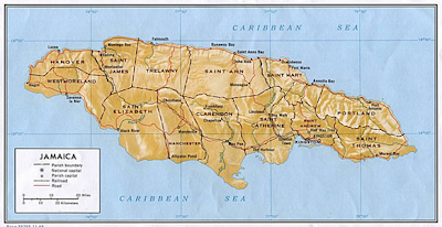
Here is an elevation map of the island of Jamaica. As you can see, Jamaica in general is rather mountainous, away from their famous beaches and coastline. The most mountains are on the ends of the island, both on the east and west sides of Jamaica. If Hurricane Dean goes south of the island, the entire island will be pretty much battered by the worst winds of the storm as the strongest winds and threat of tornadoes are always on the right side of the storm's path. A more northerly track north of the island could limit damage to the popular tourist destination. Only time will tell what track relative to the island Dean will infact take, but either way Jamaica looks to be getting the brunt from a strong Cat 3 (at the least), to a very formidable Cat 4 storm with winds of nearly 140 mph sustained at the center with gusts in excess of 160 mph. The mountains will surely make sure that the heaviest rainfall amounts are accumulated. Rainfall in excess of 10" is likely worst case scenario and this would likely cause deadly mudslides. If you know any at resorts, I am sure their vacation will be postponed and the island will be evacuated today and tomorrow and by Sunday it will be too late. Jamaica away from the resorts is a very poor country and people do not have access to strong shelters, the ones you'd find in the US. This could be a very big humanitarian disaster, but only time will tell. I hate to be a doomcaster, but all the signs are there for a major disaster and I hope the people at the highest levels are taking appropriate action to ensure the safety of countless lives.

Jamaica is only part one of this storm. After affecting Jamaica, it will head back over the steamy waters and likely come close to Cancun, Mexico another very popular tourist destination and then from there it heads into the Gulf and its anybody's guess where it goes from there.

Cool Autumnlike Weather for the Weekend

We should consider ourselves lucky to live in such a great place with no threat of tropical disturbances, at least during the next couple weeks. T.S. Erin wreaked havoc on Houston and coastal Texas yesterday with torrential rainfall on the order of 6-10"+. Downtown Houston was absolutely at a standstill with many highways leading out of the city under several feet of water, prompting many to be rescued from their cars and trees. A few people lost their lives as well when the roofs they were under caved in under the stress of several feet of water that pooled up above them. There were several roof collapses.

Here in New England, we just had to deal with a couple thunderstorms last evening and overnight that is giving us a cloudy morning, with the threat of a few more showers later this afternoon probably in time for game 2 of the doubleheader against the Angels. Don't worry this will usher in crisp air for tomorrow and cool overnight lows starting tonight. Many suburbs away from Boston will fall to around 50 degrees tonight, a few upper 40's can't be ruled out tonight. Then for Sunday morning and Monday morning, we really get cool, even in the cities where they will fall in the lower to mid 50's.

The suburbs, on the other hand, will fall into the lower to mid 40's. I would not at all be surprised if places like Norwood and Bedford, MA fall perhaps to 39 degrees. Nashua, NH is another notorious coolspot during radiational cooling nights and temperatures around 40 are possible on both Sunday and Monday mornings. Up in northern New England, many cool spots in northern New Hampshire and northwest Maine will see temperatures in the mornings into the 30's. Mount Washington will likely see some SNOW on the day Saturday with very cold readings. Scattered frost is likely in some sheltered locations of northern New England.

The afternoons will be nice though with temperatures getting into the low to mid 70's in southern New England and mid and upper 60's in northern New England. It will be very pleasant and then by the end of next week after a few days of showers and possibly storms, the humidity and warmth will be reintroduced with highs getting back to 90? By Thursday.

Wednesday, August 15, 2007

T.S. Erin Eyes South Texas for Landfall

Newly formed Tropical Depression 5 quickly became Tropical Storm Erin this morning as it quickly blew up last night. The good news with this quickly strengthening system is that is has extremely very little time to really get its act together. Landfall is a mere 24 hours away, but this storm could get its winds up to between 40-60 mph before landfall as a minimal tropical storm.

It looks like it will make landfall just north of Brownsville, TX as just that, a minimal tropical storm. It will quickly become just a plain old regular rainstorm once it gets over the mainland of Texas for a little while. The major concern will be with rain with Erin. She will dump some heavy rainfall amounts over parts of southern Texas and northern Mexico. Rainfall totals could very well exceed 4-6". Some parts of the southeast coast of Texas could see rainfall amounts approach 10", which would certainly deliver some flooding to the water logged state of Texas. The rains from this system will move up through the middle portion of the state by Friday and Saturday and this will give parts of Texas that do not need any more water, a good soaking of rainfall on the order of 4-8". The rich get richer.

I am still watching Tropical Storm Dean as it now has winds up to 60 mph. Its track has been all over the place the past few days, but it finally looks like we are starting to see a concensus. It looks like the Atlantic Ridge will keep the storm south of the islands of Puerto Rico and the Dominican/Haiti. It should pass very close to the southern shores of Cuba, probably as a Category 3, major, hurricane. Then it is fair game for folks in the Yucatan to everyone along the Gulf Coast from Mexico to Florida. Latest models keep taking it over the northern part of the Yucatan as a major hurricane and then spit it back out over the warm waters of the Gulf to maybe hit northern Mexico or southern Texas as T.S. Erin is doing. Obviously, Dean would have winds much higher than Erin, probably closer to Category 1 or 2 strength at this time if the Yucatan weakens it. Its still a long ways out so any specifics would be irresponsible at this time, so just keep Dean in the back of your mind for now. This will be a big topic come Sunday.

For now, enjoy our great weather. Its been a great summer.

Tuesday, August 14, 2007

Tropical Storm Dean is Born

Tropical Storm Dean has just formed within the past few hours and is now centered east of the Windward Islands with maximum winds of 40 mph. Dean is expected to follow a westerly track before heading more NNW towards the island of Puerto Rico later in the period, as the first hurricane of the tropical season.

Here is the statement from the NHC:

"...DEAN FORMS IN THE DEEP TROPICS...MIDWAY BETWEEN AFRICA AND THELESSER ANTILLES...

INTERESTS IN THE LESSER ANTILLES SHOULD MONITOR THE PROGRESS OFDEAN. AT 1100 AM AST...1500Z...THE CENTER OF TROPICAL STORM DEAN WASLOCATED NEAR LATITUDE 11.7 NORTH...LONGITUDE 39.4 WEST OR ABOUT 1030MILES...1660 KM...WEST OF THE SOUTHERNMOST CAPE VERDE ISLANDS ANDABOUT 1490 MILES...2400 KM...EAST OF THE LESSER ANTILLES.

DEAN IS MOVING TOWARD THE WEST NEAR 23 MPH...37 KM/HR...AND THISMOTION IS EXPECTED TO CONTINUE DURING THE NEXT 24 HOURS.MAXIMUM SUSTAINED WINDS ARE NEAR 40 MPH...65 KM/HR...WITH HIGHERGUSTS. SOME GRADUAL STRENGTHENING IS FORECAST DURING THE NEXT 24HOURS.TROPICAL STORM FORCE WINDS EXTEND OUTWARD UP TO 35 MILES...55 KMMAINLY TO THE NORTH OF THE CENTER.ESTIMATED MINIMUM CENTRAL PRESSURE IS 1004 MB...29.65 INCHES.REPEATING THE 1100 AM AST POSITION...11.7 N...39.4 W. MOVEMENTTOWARD...WEST NEAR 23 MPH.

MAXIMUM SUSTAINED WINDS...40 MPH.MINIMUM CENTRAL PRESSURE...1004 MB.THE NEXT ADVISORY WILL BE ISSUED BY THE NATIONAL HURRICANE CENTER AT500 PM AST.

Next post later on.

Smooth Sailing

Today is a perfect day and tomorrow will be much of the same for all of SNE. Wednesday's highs will get to between 85-90 degrees regionwide, except the usual places of the South Coast and Cape. This could be our last real warm day for at least a week as cool air is moving into our area to round of the end of this work week.

The transition begins on Thursday with scattered showers and thunderstorms, a few could be strong to severe. The humidity will likely come up to more humid levels by this date as well. Those showers and thunderstorms will likely finish early Friday here in eastern New England. Temperatures on Friday will not be really affected with highs around 80 still. Then the weekend comes and it will be cool and dry.

Saturday and Sunday will be mild with highs in the lower 70's. Overnight lows will get pretty low, mainly in the mid-upper 40's in the suburbs of SNE. The normally cooler locations like Bedford, MA and Norwood, MA will likely get below 45 degrees for the second time this summer. Monday stays cool, but showers will likely move in to usher in tad warmer air for later next week.

We will be watching Tropical Depression 4 all the while as well. It could be a big one. Stay tuned for later updates.

Monday, August 13, 2007

Tropical Depression 4 Forms

...FOURTH DEPRESSION OF THE SEASON FORMS IN THE FAR EASTERNATLANTIC...

AT 1100 AM EDT...1500Z...THE CENTER OF TROPICAL DEPRESSION FOUR WASLOCATED NEAR LATITUDE 12.0 NORTH...LONGITUDE 31.6 WEST OR ABOUT 520MILES...840 KM...WEST-SOUTHWEST OF THE SOUTHERNMOST CAPE VERDEISLANDS AND ABOUT 2000 MILES...3220 KM...EAST OF THE LESSERANTILLES.

THE DEPRESSION IS MOVING TOWARD THE WEST NEAR 21 MPH...AND THISGENERAL MOTION IS EXPECTED TO CONTINUE DURING THE NEXT 24 HOURS.MAXIMUM SUSTAINED WINDS ARE NEAR 35 MPH...55 KM/HR...WITH HIGHERGUSTS.

SOME STRENGTHENING IS FORECAST...AND THE DEPRESSION COULDBECOME A TROPICAL STORM DURING THE NEXT 24 HOURS.ESTIMATED MINIMUM CENTRAL PRESSURE IS 1005 MB...29.68 INCHES.REPEATING THE 1100 AM EDT POSITION...12.0 N...31.6 W. MOVEMENTTOWARD...WEST NEAR 21 MPH. MAXIMUM SUSTAINED WINDS...35 MPH.MINIMUM CENTRAL PRESSURE...1005 MB.

THE NEXT ADVISORY WILL BE ISSUED BY THE NATIONAL HURRICANE CENTER AT500 PM EDT.

Nice Stretch Continues...

There isn't much that can be said about this weather we have been enjoying. The humidity this morning will be pushed out to sea and we will have a great Tuesday. Wednesday, the humidity tries to get back at us, and the risk of showers will be with us. The pick of the week will be Thursday with mostly sunny skies and temperatures in the low to mid 80's. If this is a day where you can get to the beach, I strongly advise you to get there. We are running out of beach days, quickly. Friday will be another day of showers and storms, that will usher in some great fall-like weather for the upcoming weekend. Morning lows will be in the upper 40's away from the cities in SNE and afternoon highs will rebound into the mid 70's, all with very low humidity. Don't worry, I'm sure we will have temperatures in the 90's again before the conclusion of this summer.

Sunday, August 12, 2007

Perseid Meteor Shower Tonight

The Perseid Meteor shower is tonight and starts around 10PM, this evening, the 12th of August and will peak sometime after midnight and continue until dawn. You will generally see 1 meteor every minute, but could see up to 3-4 a minute in the peak of the show. Generally it lasts until 10PM to 4AM.

Viewing should be fine, just a little too many clouds for perfect viewing, but it will be nice with lows in the low to mid 60's tonight.

Saturday, August 11, 2007

Great Vacation Week

If you picked this week to be your vacation week, you should go play the lottery right now. This could be one of the best stretches we have seen so far this summer. Now that the summer days seem to be dwindling, you have got to take advantage of this weather that we are getting.

Tomorrow will be a hot day, but it will not be that oppressive type of heat that we have become accustomed to. It will be a dry 90 degrees. In fact instead of heat indices being 2-3 degrees higher than the actual temperature, you may see heat indices of 87 degrees with an actual air temperature of 90 degrees. Thats called a dry heat. Make sure you have enough liquids with you if you plan to spend the day outdoors for any prolonged period of time. A front moves through on Monday which will knock down temperatures with a few widely scattered thundershowers, but they won't be anything to write home about.

It ushers in a nice and refreshing Tuesday after another cool morning on Tuesday, suburbs around 50 and the city around 60. We warm up again on Wednesday for a one day stand and then it is back to the 'cool' but pleasant air for later in the week.

Overall, you can't ask for much more than that.

A Cold August Morning

We woke up to a cold morning this morning all across New England, especially in the lower elevations of SNE. Temperatures really cooled off nicely with no wind last night and clear skies, perfect for radiational cooling. Yesterday was a cool day to start with so with highs right around 60, and then the skies clearing right at sunset, it set the stage for an abnormally cool morning this morning, especially in Boston's nearby suburbs.

The big winner last night was Norwood, MA. Overnight they fell to a chilly low of 41 around 4-5AM this morning. Bedford, MA was also very cold this morning, coming in with a low of 45 degrees. Boston, protected by the ocean and being a big city with lots of concrete to hold in the day's heat, stayed in the middle 50's, falling to a comfy 56 degrees, still very cool for the city of Boston in mid August. There is nothing like a crisp August morning with heavy dew and temperatures in the 40's and 50's widespread. The temperature rose some 40 degrees in Norwood this afternoon with temperatures getting all the way to the lower 80's there this afternoon.

Don't expect low 40's in Norwood tonight. They will probably have another cool night, maybe mid 50's, but tomorrow they along with the rest of SNE will start to bake once again with temperatures getting back in the 85-90 degree range for Sunday and again on Monday. Humidity will be low with dewpoints in the 55-60 degree range so it will be tolerable.

I will try to put out an extended forecast for this upcoming week. It looks to be a good one for vacationers.

Friday, August 10, 2007

Cold and Damp Today; Tropics Set to EXPLODE!

When was the last time you can remember an August afternoon like this one, especially in Worcester. The temperature was in the upper 50's this morning there and since has slid back into the low 50's the entire afternoon! Talk about November weather in the middle of August when the average high for much of SNE is around 81 degrees. Here in the Boston area, it has not been that cool, mainly because most of the rain has stayed away from us, but temperatures have remained in the low 60's, which is about 20 degrees below the normal for this date. Its very cool.

Now there are signs on our computer models that the tropical Atlantic is about to go bonanza! It is developing some rather intense looking tropical entities in the 6-10 day frames for the Carribbean and then eventually developing something very intense looking towards the western Atlantic later in the period, towards days 8-10. The sea surface temperatures are extremely high right now since there has been very limited activity to cool the water temperatures. We could be getting into the big bang part of our hurricane season the next 1-2 months. There could be 3-4 named storms at once in the peak of our activity.

It is still a long ways out for these computer models, so it is just something that we should put in the back of our minds. For now.

Thursday, August 09, 2007

Friday Washout

Today was one of those perfect summer days. There was 100 percent of the available sunshine, a light breeze from time to time, very low humidity with dewpoints in the mid 40's this afternoon, and warm highs inland, around 80, to a nice seabreeze at the shore, lower 70's. It doesn't get much better than this. Thankfully, September is filled with these exact kind of days here in the Boston area, so we have that to look forward to. Some of the best beach days are in September here in SNE. We get warm temperatures, the ocean temperatures are at their warmest, usually peaking into the lower 70's, and no crowds because everyone is at school. However, tomorrow will not be one of those great SNE beach days. The water will be warm, but it will be very cool at the beaches and rain will fall throughout the entire day, from morning until night. The heaviest of the rain will fall in western and far southern New England, but we here in eastern New England will get into the action as well.

However we will pay for this perfect weather tomorrow. That storm will affect all of SNE tomorrow with a plain old fashioned rainstorm. It will be pretty much raining from the time you wake up until the time you get home from the evening rush. The rain will push into parts of western New England early in the morning, likely between 6AM-8AM. Then it will push eastward and be in the Boston area by 10AM. The rain will get heavier later into the early afternoon. Temperatures will drop in the afternoon with a raw NE wind. High will likely be early in the morning, mainly in the lower to mid 60's. By 4-6PM, temperatures will drop into the upper 50's and it will feel very fall-like.

Here is a map for the rainfall. It is pretty much similar to what I had up last night, just made the inch area a little smaller and not all the way into the North Shore. There will be a sharp cutoff with this rain from getting heavy amounts to basically getting nothing.

In the dark green area, a good 1-2"(+) is likely. This is much needed rain for parts of SNE, as some areas have really gotten jipped the past few times that we have had localized rainfalls, mainly because of the scattered nature of thunderstorms. The Cape could really use some rainfall. It does look they will finally get some and it will be a soaking rainfall. Its official, Friday will be a washout in SNE. If you have any plans outdoors, expect to get wet and if you can't, you probably will have to resort to Plan B or cancel your plans alltogether. Don't worry though, Saturday will be better and as you can see in the extended forecast we will bask under partly cloudy skies and temperatures in the upper 70's.

Wednesday, August 08, 2007

Early Look at Friday's Rain

The latest guidance is showing some decent rainfall, especially for far southern New England now for Friday and into early Saturday, unfortunately. I though that this system would try to develop a little slower and more south of Long Island, but it now appears that it will get its main rain band all the way up past Boston, maybe even into southern New Hampshire. As this system gets closer to the coast, an area of low pressure will develop around Long Island Sound and this will do nothing more than to enhance the area of rain and cause the rain to get quite heavy along the CT coast, into most of Rhode Island and into the Hartford metro area. Boston to Worcester will not fair that well with the latest runs of the models as well. Moderate rain on the tune of one-half to one-inch is possible with this rain that will come just before this weekend.

Where it falls heaviest, in the yellow shading, a good 2" or more of rain can be anticipated. This will raise the concern for some street and small river flooding believe it or not. We will not have flooding in the Boston area, but it will be one of those rainy days that you kind of need in the summer just to make you sit back and take a second. So, if you have to get to the beach this week, make sure that you call in sick tomorrow because Friday will be anything but a beach day.

I will make another forecast for this tomorrow. Maybe we can push the flooding rains south off of the South Coast and spare unnecessary headaches.

Perfect Thursday

Tomorrow is going to be the best day of the summer. One-hundred percent sunshine with temperatures around 80. There may be a few afternoon wispies, but that would be just about it. It will be perfect for the beach, pool, yardwork, or what ever is on your to do list.

The same can't be said about Friday and Saturday. Its not going to rain nonstop for both days, but it will just have that unsettled look to it and we could see periods of rainfall and showers. We aren't talking inches upon inches of rain like we can see in the springtime, but it will be enough to cause puddles and maybe cancel a few baseball games on Friday evening. It will be a nuisance rain at most. Friday will be the wettest day with cool highs only getting to around 70 with a raw NE wind. Saturday will come up a few degrees, mainly because there will be more dry periods and if we get some sun, highs could make it to around 80 or slightly higher.

Sunday we start to cook again with highs back into the upper 80's in much of SNE before another round of showers tries to cool us down again on Monday, yielding a great Tuesday. Its like we are in an every other day cycle. We get a dry day followed by a wet one. Two dry days, followed by two unsettled days. The cycle will continue. At least for a little while longer.

Tree Downed in Woburn...US Route 3

Driving home today through the Woburn area, there was a rather intense little shower that moved through parts of Boston's immediate NW suburbs. I noticed the clouds got dark and the rain fell heavily for a few minutes with very gusty winds associated with this shower.

The winds were so intense that they caused a tree to be downed right onto the main road in Woburn near Four Corners and the I-95 JCT. There was a major backup all the way into Winchester with this downed tree as it took up one side of the street, only allowing one lane to get by at a time.

This band of showers, without thunder, oddly, marks the drier air moving into SNE tonight and overnight lows will likely get into the mid 50's in some of SNE tonight! More on the forecast later.

"Change is a Good Thing"

The first sign of the changing season is upon us. I have been watching with much interest, the cold building in northern Canada. The GFS has continued to show this cold building, slowly, but surely in the northern reaches of Canada. Basically, this cold is farther north than where many actually live. Its the first sign of the cooling northernmost part of our planet. Daylight is slowly dwindling in the northern hemisphere.

Don't worry about this cold, however. These are the 850mb temperatures for later on in the month. As you can see, the lower 48 and even much of southern Canada will still be seeing extreme summertime heat with temperatures in the 90's and 100's. Summertime heat will be all over the Lower 48 and even Alaska will be seeing above normal to normal temperatures. However, look how expansive the temperatures below 0 degrees (C) there are and how it is not blotty. The cold is slowly starting to spill over from the North Pole and sea temperatures up there will cool and ice will start to thicken. That is a good thing in establishing a cold source, almost like a refrigerator, for the fall months, September and especially October, November, and early December. This will allow cold to come farther south, earlier rather than later.

There are many other factors at play here, so we are not absolutely sure of cold coming in the next few months, but cold building up in those northern lattitudes are a good sign. We still have got a lot of summer weather to get through before we even have to worry about the cold building way up there.

Tuesday, August 07, 2007

Wet Early Wed; More Rain Friday?


Warm and Humid then Storms Wed PM

Today started our foggy in eastern New England with the fog developing as the air temperature and the dewpoint met each other around 1AM last night. The fog was quite thick around sunrise where I live and stayed thick in Boston for a while this morning. now the sun has burned through the fog and temperatures have responded well. Highs this afternoon will likely get to between 82-88 degrees.

Tomorrow may start off foggy again, but the sun will burn out in the early morning again. The sun will make temperatures soar once again to between 85-90 degrees with very high humidity. Dewpoints will stay in the 70-75 degree range once again tomorrow. Then the clouds will roll in again and rain and thunderstorms, some strong will invade our area and some spots could see some locally heavy rainfall. Up to an inch of rain could fall in some towns, while others will probably see a tenth of an inch if that.

Drier air, still warm though, moves in later in the week.

Monday, August 06, 2007

Hot, Oppressive Tuesday

Tomorrow will be one of those days that you will not want to be outside for too long, not because of rain, snow, or freezing cold, but for the oppressive humidity. Dewpoint temperatures could be at their highest levels for the entire summer thus far.

We have seen dewpoints in the 70-72 degree range quite common in the humid spells so far this summer. However, parts of southernmost New England tomorrow could experience dewpoint temperatures well into the mid to perhaps upper 70's. Most places will fall in the 73-77 degree range tomorrow concerning dewpoints. Combined with temperatures in the upper 80's to low 90's, the heat index could very well be in the 96-99 degree range. Consider ourselves lucky because tomorrow temperatures will likely be in the upper 90's in New York City and Philadelphia and low 100's in Baltimore and Washington DC. Some places in the Mid Atlantic will likely see temperatures in the 100-105 degree range for two (2) consecutive days. Thereafter, the will likely stay in the 90's throughout the rest of the week.

We, on the other hand, will have two warm days. Tomorrow with temperatures around 90 and Wednesday with temperatures in the mid to upper 80's. Humidity will be high on both days. Then we will start to really cool off and all the heat will be surpressed south of NYC. Temperatures will return to more normal levels after Wednesday's bout of rain and thundershowers, similar to what we endured this afternoon in much of eastern New England and northern New England. Parts of Maine saw a quick 1-2" of rainfall from this latest bout of downpours. Seasonable this time of year is around 80 degrees. In fact, skies will start to get increasingly cloudier by Saturday and that is when eastern New England could see highs stuck in the low to mid 70's for highs. SNE could see highs in the 70's for an extended period thereafter as well, with higher temperatures farther inland, as would be expected in the early to middle part of August.

The tropics have returned to their quiet ways after last week's hiccups. Chantal did not do much as it rocketed NE out into the "Graveyard." The tropic wave that looked promising this time last week really turned out to be a dud as well, basically disintergrating over the Yucatan. There is a weak tropical wave north of the Windwards as we speak, but no immenent development is anticipated. I guess we can consider ourselves lucky with these developments. The NHC has lowered its forecast numbers for this year as well, so it could turn out to be a non-year for hurricane enthusiasts hoping for a big one. We'll see.

Sunday, August 05, 2007

Monday's Rain and Thunderstorms

Tomorrow is not going to be an ideal day to go golfing or boating or even go to the beach for that matter. We got our very nice day today and we will have to pay for this nice weather tomorrow. Rain is currently in the Ohio River Valley, giving parts of Indiana, Ohio, Kentucky, and into Pennsylvania some good soaking rains. The rains associated with this front are returning the warm and humid air. The air that we worked so hard to get rid of Friday. The heat is coming back after this rain as well. Not tomorrow. Tomorrow we will see rain-cooled highs, mainly in the 70's, to perhaps around 80 in places like Bedford, MA and Boston metrowest. Here, I do not think they will see much if any rain. The computer models keep much of Massachusetts rather day and give good soaking rains to southern CT and extreme SW RI. Even the Cape may escape much of the worst of it.

The Cape could use some rain as I was down on vacation there for the past few days and the lawns and fields are bone dry. Where there is not any sprinklers, the grass is brown. They really need the rain down there. The salty ocean air doesn't help much either with that problem. But where the rain falls heaviest tomorrow in extreme SW SNE and much of northern VT and NH, there could be as much as an inch of rainfall, with more in locally slower thunderstorms and downpours. I wouldn't be surprised if someone winds up with 2-3" somewhere in New England tomorrow. Just not in the light green area. This area will likely just get a few passing downpours from time to time, and mostly in the later PM.

The heat returns with the humidity for one day; Tuesday. Temperatures could get up to between 85-90 at the coasts and between 88-93 inland. The humidity will be oppressive, with dewpoints getting back in that 65-70 degree range for Tuesday and perhaps Wednesday as another batch of rain and thunderstorms moves in, this time with a cold front. Then we will have dry weather with highs seasonable, upper 70's to around 80.

Saturday, August 04, 2007

Sunny Sunday; Rainy Monday

Boston had its 3rd official heatwave. The high on Thursday was 92, the high on Friday was 95, and today reached 92 once again. We will not get into the 90's again tomorrow though. The 90's will be replaced by 70's tomorrow. Infact, tomorrow morning will be a cool morning, compared to what we are used to the past few days. Lows will get into the 50's. Rain and thunder is likely Monday with up to an inch of rainfall likely here in SNE. Not going to get into the details, but Monday could be a day where you want to stay inside and go to the movies or something. Tuesday will be a hot day in between rainy days with temperatures topping out in the upper 80's. Wednesday will be similar to Monday as it will be somewhat rainy and then we are smooth sailing into next weekend with mostly sunny skies and temperatures in the upper 70's to around 80 with low humidity. You can't get much better than that for early August, IMO.

Wednesday, August 01, 2007

Hot Start to August...

Today was just one of those days that was just perfect. Mostly sunny skies, low humidity, temperatures around 80, and a light breeze. You really cannot get much better than that. Maybe a Utopia.

The weather will not stay that perfect in the coming days. Temperatures will really start to heat up come tomorrow with temperatures getting up to the lower 90's in many areas, aside from the Cape and Islands of course. The humidity will start to get into that uncomfortable range tomorrow as well. Dewpoints should get into that 65 degree range by tomorrow afternoon and evening again as well.

Friday will be one really hot day here in southern New England. Temperatures will be in the mid 90's before some really big boomers arrive later in the afternoon and evening from the WNW to the SE. Some of these storms could be quite severe with large hail, strong winds, frequent lightning and heavy flooding rains. It will clear out quickly however and we will have a really nice weekend. Temperatures will be in the mid 80's in the Boston metro area on Saturday and then on Sunday we will start to warm up again to around 90 and we will likely stay around 90-95 degrees for the next several days, probably not seeing an end to the 90 degree temperatures until the middle or end of next week, barring a backdoor cold front of course. Another heatwave? Maybe.

Dean in the Not Too Distant Future

(NOAA) SHOWERS AND SQUALLS ASSOCIATED WITH THE TROPICAL WAVE AND THE AREAOF LOW PRESSURE ARE SPREADING OVER THE WINDWARD ISLANDS AND THEEASTERN CARIBBEAN SEA. THERE ARE NO SIGNS OF TROPICAL CYCLONEFORMATION AT THIS TIME BUT CONDITIONS APPEAR TO BE FAVORABLE FOR ATROPICAL DEPRESSION TO FORM DURING THE NEXT DAY OR SO AS THE SYSTEMMOVES WESTWARD. A RECONNAISSANCE PLANE WILL INVESTIGATE THE AREAAGAIN ON THURSDAY...IF NECESSARY. This is a report from the National Hurricane Center from Miami. The satellite image is from Accuweather.

There is also another area of disturbed weather in the northern Gulf of Mexico at this time and is attached to an old mid latitude frontal boundry, which is a tell tale sign of tropical development. So, that will have to be watched closely.

More on the tropics and our steamy forecast later tonight and tomorrow. Our prayers go out to those affected by the tragedy in Minneapolis tonight once again.

Moment of Respect for Those Lost in Minneapolis Tonight...Major Bridge Plunges into Mississippi River


(MSNBC) MINNEAPOLIS - The entire span of an interstate bridge suddenly broke into huge sections and collapsed into the Mississippi River during evening bumper-to-bumper traffic Wednesday, sending vehicles, tons of concrete and twisted metal crashing into the water.
Kristi Rollwagen, the deputy director of emergency preparedness for the city, said seven people had died in the incident.
Police Chief Tim Dolan said all survivors who were on the bridge are now off. "We've accounted for all the construction workers except for one," he said.
Hours after the collapse, Mayor R.T. Rybak said rescue workers had searched 50 cars.
"Obviously this is a catastrophe of historic proportions," said Minnesota Gov. Tim Pawlenty.
The Interstate 35W bridge, a major link between Minneapolis and St. Paul, was in the midst of being repaired when it collapsed. Repairs involved guard rail replacement on the joints and concrete work, Pawlenty said.
"There were two lanes of traffic, bumper to bumper, at the point of the collapse. Those cars did go into the river," said Minneapolis Police Lt. Amelia Huffman. "At this point there is nothing to suggest that this was anything other than a structural collapse."
At least 58 individuals — 10 of them children — were injured, said officials from the Red Cross and the Hennepin County Medical Center. Six individuals being treated were in critical condition, Dr. Joseph Clinton said.
NBC News reported that every Minneapolis ambulance had been requested to the scene.
A freight train was passing under the bridge when it collapsed and was cut in two, WCCO television reported.
Police set up flood lights so rescue officials can work throughout the night.
The Minnesota Department of Transportation told local media that 200,000 cars a day use the bridge.
The bridge, built in 1967, was last inspected in 2006 and had no major structural defects or deficits, Pawlenty said. "We were told the deck would have to be replaced in 2020."
'It shook the ground'A burning truck and a school bus clung to one slanted slab after the collapse.
The school bus reportedly had just crossed the bridge before the bridge crumpled into pieces, and local broadcast reports indicated the children, none of whom were injured, exited out the back door of the bus.
MSNBC Reports...
The weather for rescue teams tonight looks reasonable with a few thunderstorms grazing the northern part of the city. After these storms pass, it should be a quiet night for those aiding in the rescue effort.
This is a very big story and I want to extend my gratitude and respect to those who have lost their lives tonight in Minneapolis.