 My snowfall forecast for this storm today pretty much worked out, but I don't think that the snow accumulated 1-3" outside of 495 in places like Acton. If anyone has observations from there, let me know. For inside of Route 495, it pretty much stayed an all rainstorm with heavy rain at times, but at around 2:30PM it turned wicked heavy and turned to sleet and briefly snow where I live and accumulated to a skim coating on the cars and dirt.
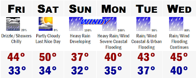
This storm is all done so lets look ahead and I am not going into any details with this storm once again because it was heard getting all the details fo this storm 12 hours out. This storm is still 3+ days away and it would be irresponsible to give any specifics. One thing is that this storm could be one of the biggest to affect the entirety of the eastern seaboard for quite some time and be a storm that will live in our memories for a while as well. Coastal residents should prepare for major to perhaps catastrophic coastal flooding from this storm. Start thinking about your plan of action now so you will not be caught off guard. Right now if my arm was twisted and I had to tell you what precip type most of SNE would see, especially eastern SNE, I would say that we would face heavy rains with sustained winds of 40-60 mph along the coastal plain and 30-40 mph just inland. Power outages, even without the snow, could be a real possiblility here on Marathon Monday. Tropical storm force winds are nothing to sneeze at and wind gusts could very well approach Hurricane Force levels of 70+ mph. And here I go, getting into specifics, so I will stop talking about this and say to stay tuned to the weather the next several days.
This could be a biggie.
No comments:
Post a Comment