 What a morning we had today. I woke up with my backyard totally under water and the temperature on my home thermometer read 68 degrees. SNE was warmer than most of Florida this morning, the exception was Miami where they were 69 degrees when Boston was 68. It was that tropical out there today.
It has cooled off and dried out a bit, the lawn is still under water and my neighbor is still pumping water out of his basement, but last night's amazing storm is the last storm we will see for a while, at least the next week.
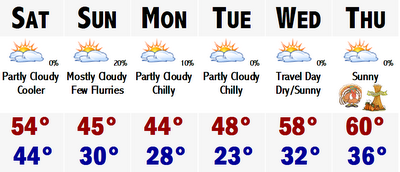
This week looks to be tranquil and gradually turning cooler. Tomorrow should be in the 50's and then we will slip into the mid-upper 40's on Sunday with a slight, and I mean slight chance of a sprinkle or first flurry for any given area, excluding the Cape. Monday will be dry, but cool still with highs in the mid 40's. Tuesday, maybe a tad warmer in the mid-upper 40's. Then, it looks like the limited source of our cold air will be used up and the coolness will retreat and I see no reason why not to put temperatures back up into the 50's for Wednesday and see no reason not to go for a "morally perfect" high of 60 for Thanksgiving. Highs will likely be in the mid 50's, but chose to go with the 60 for a benchmark. People will remember a Thanksgiving at 60, better than the 50's. Some towns like Taunton, Carver, Norwood, and Bedford may come close to 60. Looking beyond Thanksgiving, we may cool down a bit going into next weekend, but there is no real cold air in Canada at this time, so I just can't forecast any long, prolonged cold air invasions that will lead us into December and the winter season.
The cold air is bottled way up in Alaska and the Yukon. Other places in Canada are not that chilly. Many areas near central Canada are just not that cold. Highs in the mid-upper 20's is not a cold source of air that can sustain itself over our area. It is not true Arctic air that can keep us cold and give us a chance at some white storms.
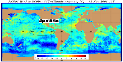
 This bottled up Arctic air may be a major sign pointing at El Nino and a mild winter. I am showing the warming water in the eastern Pacific in this map and it is showing a tell tale sign of the infamous El Nino. Warm water is starting to bank up against the northwest coast of South America.
 I am not ready to buy into this El Nino stuff quite yet and give up on this winter, but it is starting to become more and more evident that this just plain and simple may not be a snowlovers winter. Could this change? You bet, but its unlikely to reverse this type of pattern in such a short time to have a good snowy winter.
One thing is for sure. It sure felt like S-U-M-M-A-H this morning...INSANE WEATHER. If this morning was an indication of what kind of winter we will have...instead of getting the ski and snowboard ready, just invest in a pool, dig the hole and use it for seven or eight months out of the year. I dunno what to say.
LATAHH
9 comments:
RAY-Andrew, I concede the fact that warmth in Nino region 1.2 is not a good sign for a snowy winter, but I do not think that this will become a strong Nino, thus you not throwing in the towel is the prudent choice! I will take my chances on high latitude blocking returning the latter half of Dec provided the Nino does not become strong, 1.2 is very unstable and will probably cool relativley rapidly.
RAY- FWIW, the cold is not being "bottled" up north because of the el Nino, this is directly attributed to the Pacific fire hose inducing +EPO, once the EPO rises the warmth will abate. This is what happened last year, but the difference is that it happened in Jan as opposed to Nov, and this time around there IS cold in Canada and Alaska...last year there wasn't. The reason that it is quite folly to attribute this warmth to the +ENSO is that the damn thing isn't even effecting us yet, the PDO is negative and there is no split flow as of yet, the ENSO effects will likely commence in Dec once the lag runs its course. The rcord setting rains in the PNW this month are actually indicative of la Nina.
RAY- I meant once the EPO falls, not rises.
Yes, I agree with you...in the fact that the cold has not been able to penetrate southward because of this fast paced jet stream slamming into the PNW and I do believe that Seattle has had the wettest November on record so far, I'll check my sources, and this is forcing mild marine Pacific air across the nation, modifying any type of cold we do occasionally get from Canada.
And yes, there is cold in Canada, and Alaska. They have been FRIGID with temps way below zero for a while. This cold is building and as I read on the Eastern WX Forum, this will likely come at us in Jan or Feb.
We'll see.
But you have to agree that that warming off the South American coast is a tell tale sign of El Nino...
We may not be getting directly affected by it now, but it will start to play a role in the L48 forecast if it does indeed gets stronger.
RAY- Andrew, el Nino is a GOOD thing for snow in the east, of course there have been some years in which it became very strong and killed the winter, but that will NOT happen this year! 1)There has NEVER been an el Nino that developed as late as this one has and gone on to be strong! 2)Even if it were to become strong, which is possible but historicaly unlikely, the atmosphere would not experience strong el Nino conditions until the spring because of the lag! We will have a moderate el Nino this winter, not strong. In conclusion, warm ENSO events (el Nino) average more snowfall in SNE than ENSO neutral and cool ENSO events (la Nina), the only exception is in strong Ninos, weak and moderate Ninos are generally favorable. The only way that this winter will end up crappy is if the NAO averages very positive.
Yup I agree with you....if I am not mistaken 2002-2003 was a setup similar to this one...and forecasts were similar to this year's and we wound up with 6 FEET of snow in Boston..with the President's Day Weekend Blizzard dropping 1-2 feet of snow from DC to Boston.
ERIC- Its finally cold out there. Are you buying into the TV forecasts, Ray and Andrew of nearing 60 by the end of next week?
No real cold till Christmas?
ERIC-My birthday's Dec. 18, will we have snow on the ground?
For the 24-25th?
Post a Comment