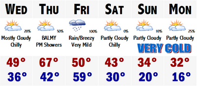
 Its that time of the week again. Time to say how amazingly warm it is about to get, yet again, now only days away from the arrival of December. Today we had a fairly typical New England November day with highs in the low 40's with a wind off the water with patchy drizzle and dark overcast skies. It was actually a little chilly today. No fear, tomorrow will start the rebound. After a chilly start with temperatures in the mid 30's to head off to work and school, temperatures will rebound to around 50. A little warmer towards CT, cooler north. Then there is no stopping the rollercoaster ride heading into Thursday. Another Thursday and another headline of pushing 70 by Thursday. Highs probably will not reach 70, but it will soar remarkably into the mid-upper 60's, an amazing feat for this late in the year with such a low sun angle. The rain, mostly showers, move in overnight Thursday and persist most of the day Friday. Once the front passes, rain may briefly change to snow across the northern New England mountain tops with perhaps a light accumuation. This front will mark the end of the April like warmth here.
 Saturday will sort of be a transition day. It will not be mild by any stretch of the imagination, but it will not be arctic cold. It will be reasonably or seasonably chilly with highs like we had today, mainly low-mid 40's, but with more sunshine, under partly cloudy skies. It will get cold though. Highs Sunday, for the Patriots game at Gillette will be chilly. Highs may struggle to reach the mid 30's. Gametime temperatures will likely be around 35 degrees at 1PM for the kickoff at Gillette Stadium. There won't be snow, which I guess is a good thing for the fans. Fans in Seattle were not as lucky last night, dealing with a very rare Seattle Snowbowl last night on Primetime Monday Night Football. It was pretty cool to have a city like Seattle showcase real football weather.
Monday the cold will truly be entrenched as highs even in Boston will probably stay around the freezing mark, mainly lower 30's. A storm looked like it was going to be threatening our area sometime Monday with light to moderate snowfall, especially south and east of Boston, but it looks with each passing run of the computer models, the idea of this potential storm and chances of it bringing us our first snow are dwindling. In other words, don't bet on it.
I guess thats all for tonight. Enjoy Thursday's amazing warmth and stay warm (and dry) tonight.
5 comments:
JEN- Any chance of seeing some snow around here in Worcester Friday night?
I watching channel 4 this AM and it showed snow for Monday. Now its sunny. Could it change back to the snowy forecast?
To answer your question Jen, probably not, sorry.
Reasoning: The computer models. The two most reliable, the GFS and NAM are following the same tune pretty much. NAM is more of an inland runner over western NY state with any changeover confined to the Canadian border and highest moutaintops. GFS has a storm track more over western New England which is a much "colder" storm track for us. Most if not all of the precip would fall in the form of rain, but the changeover would be further south, probably more like central New England, still leaving Worcester snowless this winter/late fall.
More bad news is that another city is likely to be added to cities that have experienced their first snowfalls. Recently added was Seattle. Next on the list looks to be Dallas, TX...most northern TX towns/cities...Oklahoma City...Tulsa...Kansas City...and perhaps Little Rock, AR.
And the storm for Monday. Fo-get about it.
RAY- Andrew, Andrew, Andrew, come on guy...ur better than that! You jumped the gun dawg, you should have known with the models', esp. the GFS, deplorable continuity of late! Here's a historic tip, "don't fire until ya see the whites of their flakes". lol
RAY- First snowfall lookn' more likely Dec 5.
ERIC- Pretty crazy weather out there and its not here.
Right now DALLAS, TEXAS is approaching 80 degrees, and is under a Tornado Watch. If thats not enough they are also under a Winter Storm Watch as well. Thats freaky.
Seattle, WA is under a Winter Storm Warning with another snowstorm moving into the coastal areas of the PNW.
Boston's high tomorrow around 70.
I love this kind of weather.
Post a Comment