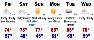
Back to the weather and simply, a perfect week is ahead. Cool days to begin and near record COLD on Sunday morning. The warming early next week back into the 80's, before we cool off and dry out again later next week back towards an early autumn feel.
Lows Saturday morning will range from the upper 40's in Boston's suburbs and interior and northern New England to upper 50's in the urban areas.
Lows Sunday morning could reach RECORD levels. The record low for Boston's International Airport for this date is in the lower 50's and we could possibly see a low just about 52 or 53 which could tie or even break the record. Given that you know that lows will be mighty chilly in northern New England and in the deep valleys where temperatures could be in the 38-42 degree range. Around here in the coolest regions of southern New England, lows in the mid to upper 40's should be widespread. Mount Washington in New Hampshire could actually fall below freezing for a little while on Saturday and Sunday morning. No frost for us this weekend, but it will be very autumn like when you go to get the morning paper in your slippers Sunday morning.
No comments:
Post a Comment