Friday, November 24, 2006

Spring-Like Week Ahead

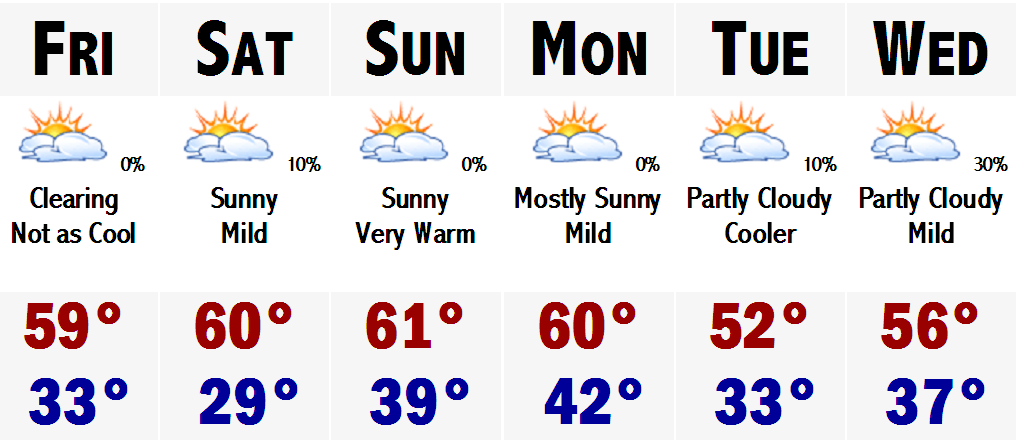
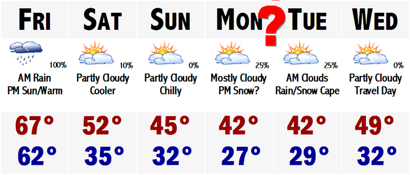
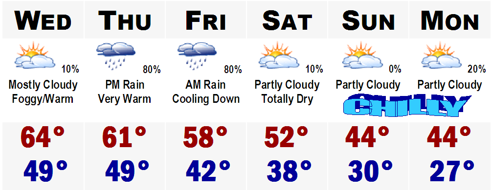
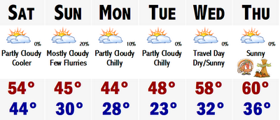
There is not much to talk about tonight. Just thought I would put out the 5 day. It looks to be a quiet week with no storminess, which is nice as many areas saw flooding rains last night. Enjoy the warmth, which will likely last until about Friday of next week. Highs during this week will average around 60 Saturday through Monday, then a backdoor cool front may cool us down into the mid 50's for Monday and Tuesday. It may be a tad cooler by the coast during these days as a sea breeze may come into effect, with highs in the upper 40's to around 50. We are back into the 60's for Thursday and possibly into Friday before the AX falls next weekend.

Have a nice weekend. Post soon.

Thursday, November 23, 2006

Is it Mid April?

Say adios to the rain, wind, and cool temperatures for a while. After today's late November Nor'easter, amazing there was no snow involved, it looks like things will be on the upswing.

It now looks like SNE is on the verge of another amazing warmup. Tomorrow with the storm departing, temperatures should respond nicely to between 55-60 degrees in much of SNE, exception will be Worcester, maybe only 50. If thats not a nice enough treat, wait until Saturday. There will be 100% sunshine and temperatures will be within a degree or two of 60.

Still not good enough? Well, then you will love Sunday. It should be mostly sunny again and highs should respond nicely up into the lower to middle 60's with dry conditions. No threat of rain. It will continue into Monday with highs in around 60. A frontal boundry will go throught the area Monday night-Tuesday and temperatures will "fall" to around or slightly above normal conditions. Mainly around 50. Wednesday southerly breezes will be back and highs should have no problem rebounding back well into the 50's. Right now it looks like Thursday of next week could be the warmest of the next bunch. Highs may be approaching mid-upper 60's. Its a long way out, so stay tuned.

FWI, parts of the DEEP SOUTH have already seen their first snow. Thundersnow was reported in Charleston, SC this past week. Snow accumulated up to 2" in Augusta, GA and snow was reportedly mixing in with light rain all the way down to the suburbs of ORLANDO, FL.

NOW TALK ABOUT WACKY WEATHER! A storm that brought SNOW to Orlando, FL is bringing ALL RAIN to New England.

Go figure.

Saturday, November 18, 2006

Playing it Conservative

We finally had a normal November day around these parts. First one in quite a while. Tonight will be a quickie post, hopefully I can get a bigger one out sometime early next week. There is nothing to talk about and lots to talk about. The nothing part is the forecast for the next week. I guess it is good that there will be little "weather" across the nation this week as it is a busy holiday travel week. The one exception may be down on the SE coast, near coastal Georgia and the Carolinas. The coastal storm we have been advertising and barking about on this page, Eric, Ray and me, will develop. Just it will stay down there and crank up the wind, rain, and seas for them. It may try to come up the coast later on in the week and at this point with the GFS, it could throw a few rain showers on the Cape and the Islands by sometime Friday or heading into next weekend.
Temperatures are on the downswing right now. Tomorrow will stay in the 40's and it will stay that chilly all the way until about Thanksgiving, as temperatures will slowly start to moderate, ahead of another storm that will likely cut to the west of us again, bringing in mild, rainy conditions later next weekend possibly, before cooling down again and likely warming up ahead of another storm upstream. The cycle continues.
Ray...thanks for stopping me getting carried away with the El Nino stuff and blaming the Nino for all of the warmth across the Lwr 48. Relative warmth that is. It is a variety of factors, but mainly whenever you get the jet stream slamming into the PNW, ie Seattle, storm after storm that pummels the coastal plain with inches upon inches of rain and mountains with feet upon feet of snow, it throws that mild Pacific air across the nation...limiting any cold air and any Arctic invasions. Until this stops, instead of getting Arctic Canadian cold we will continue to get "Polar" Canadian cold, which is not as cold/weaker, and does not last as long/modifies faster. In the next 7-10 days, I do not see this pattern switching all that much so, I am going with the "conservative" forecast of sticking with "What you see, is what you get." Once it switches though, OH, we'll know it.
PATRIOTS @ PACKERS Tomorrow 1PM
Kickoff: Partly Cloudy 35
Halftime: Partly Cloudy 37
End: Partly Cloudy 39
MY PRE-DICTION...PATS 27 PACKERS 17
Thats all for tonight.

Friday, November 17, 2006

Quiet Weather Dominates Into Next Week

What a morning we had today. I woke up with my backyard totally under water and the temperature on my home thermometer read 68 degrees. SNE was warmer than most of Florida this morning, the exception was Miami where they were 69 degrees when Boston was 68. It was that tropical out there today.
It has cooled off and dried out a bit, the lawn is still under water and my neighbor is still pumping water out of his basement, but last night's amazing storm is the last storm we will see for a while, at least the next week.

This week looks to be tranquil and gradually turning cooler. Tomorrow should be in the 50's and then we will slip into the mid-upper 40's on Sunday with a slight, and I mean slight chance of a sprinkle or first flurry for any given area, excluding the Cape. Monday will be dry, but cool still with highs in the mid 40's. Tuesday, maybe a tad warmer in the mid-upper 40's. Then, it looks like the limited source of our cold air will be used up and the coolness will retreat and I see no reason why not to put temperatures back up into the 50's for Wednesday and see no reason not to go for a "morally perfect" high of 60 for Thanksgiving. Highs will likely be in the mid 50's, but chose to go with the 60 for a benchmark. People will remember a Thanksgiving at 60, better than the 50's. Some towns like Taunton, Carver, Norwood, and Bedford may come close to 60. Looking beyond Thanksgiving, we may cool down a bit going into next weekend, but there is no real cold air in Canada at this time, so I just can't forecast any long, prolonged cold air invasions that will lead us into December and the winter season.

The cold air is bottled way up in Alaska and the Yukon. Other places in Canada are not that chilly. Many areas near central Canada are just not that cold. Highs in the mid-upper 20's is not a cold source of air that can sustain itself over our area. It is not true Arctic air that can keep us cold and give us a chance at some white storms.
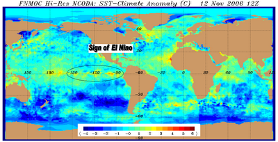
This bottled up Arctic air may be a major sign pointing at El Nino and a mild winter. I am showing the warming water in the eastern Pacific in this map and it is showing a tell tale sign of the infamous El Nino. Warm water is starting to bank up against the northwest coast of South America.
I am not ready to buy into this El Nino stuff quite yet and give up on this winter, but it is starting to become more and more evident that this just plain and simple may not be a snowlovers winter. Could this change? You bet, but its unlikely to reverse this type of pattern in such a short time to have a good snowy winter.

One thing is for sure. It sure felt like S-U-M-M-A-H this morning...INSANE WEATHER. If this morning was an indication of what kind of winter we will have...instead of getting the ski and snowboard ready, just invest in a pool, dig the hole and use it for seven or eight months out of the year. I dunno what to say.
LATAHH
Thursday, November 16, 2006

Windswept Rain Tonight

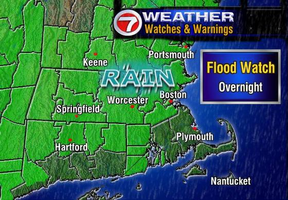
Its past the halfway point of November and we are still seeing temperatures near 70 in Taunton, MA. Here NW of Boston, it is currently in the mid 60's with Boston checking in at 68 degrees. Will this last? Well, for the next 24-30 hours, it will last. Tomorrow looks to be like another mild day with highs in the mid 60's after morning rain. Tonight we are under a FLOOD WATCH, everywhere except SE MA. Expect rainfall to be on the order of 1-3", possibly 4"+ tonight.
There could be localized flooding during this timeframe as most of the rain will likely fall in a 4-7 hour time frame.
The link to the side is from WHDH BOSTON and shows just where the FLOOD WATCH affects. As you can see southeastern MA and southern CT is not under this FLOOD WATCH, but that does not mean that you will escape the rain. It just means that the heaviest, flooding rains, will probably not occur over you. Still, expect 1-2" of heavy rain tonight.
Looking down the line towards this weekend, Saturday, although cooler, still looks to be a tad above normal on the high temperature department. Highs should be in the mid 50's. Middle 40's are likely here Sunday and Monday. Then Monday night, there could be a coastal storm quite close to us at this time. It will be quite cold at this time with temperatures likely in the 30's. Computer models are showing that this storm system could throw some precipitation into eastern and southeastern New England at this time, possibly as a rain/snow mix. This is so far out, 4-5 days, and the track will likely change with each new run of the computer models which come out every 6 hours, that it is too early to forecast anything or side any which way. It would not be professional. But since this is not a professional site, I can tell you what exactly I am thinking.
I believe that the models will bring this closer and closer to the west, but then keep it far enough out to sea that it does not really have any effect on us here in Boston. Also temperature composites will likely come up from the borderline rain/snow line, safely above the critical 0 degrees C at 540 mb. So, expect a few sprinkles or a shower down on the Cape, perhaps just on the Islands.
Thats all for today...PEACE.

Tuesday, November 14, 2006

"Brighter Than Sunshine"


Okay. It is now the halfway point in November, Boston's gloomiest month. Well, Boston has lived up to that reputation the past few days with nonstop showery rains, fog, clouds, and drizzle. However, it has been unseasonably warm the past several days as well. Highs have been ranging from the upper 50's to mid and upper 60's. Averages for this time of the year should be around 52 degrees.

Guess what? Much of the same is forecasted for Wednesday and Thursday. Tomorrow there will be limited or no rain. We actually may see some sunshine and if we do, you guessed it, highs back in the mid 60's. If not, upper 50's to around 60 is all right too. Highs around 60 again on Thursday with another rainstorm moving in for the night. Looks like this will be an all night rainstorm with about another 1-2" throughout much of SNE. That will move out Friday morning and highs will be "cooler" still above average, in the upper 50's to around 60.

Even colder air will move in this weekend and early next week with highs in the mid 40's. Lows will get back down below freezing again. Upper 20's are likely again by Monday morning. Travel Day Tuesday, the 22nd, looks to be nice across much of the eastern U.S. A storm will be out to sea, which the track has been fluctuating, but current indications are that it will stay well out to sea.

Thanksgiving looks to be nearing the end of our mini "Cool Spell." Highs on Thanksgiving should range from the upper 40's NW to lower 50's down on the Cape. Gametime temperatures should generally be in the lower to mid 40's. Thereafter, it looks like the rollercoaster ride will continue as temperatures will be back on the upswing. Highs back into the positive range with highs back well into the 50's.

The next significant cooldown does not look probable until early December after the Thanksgiving mini cooldown. As you know, these weather patterns are very finicky, so please check back with Southern New England Weather for updates.

See you soon.


Monday, November 13, 2006

Gloomy Times...


Gloomy times are here and here to stay they will. After a rainy and gloomy Sunday with both the Patriots and Revolution losing their games, Monday has turned out to be just as gloomy. Guess what? Tuesday promises to bring much the same with even more rain than we have seen today and yesterday. One good thing is that the rain will quit on Wednesday and if we see some sunshine highs could rebound all the way into the middle 60's.
Same in the temperature department for Thursday, mid 60's, but rain will be developing during the afternoon for more gloomy times. Rain will continue into Thursday night and early Friday morning with perhaps another 1-2" of rain after Sunday's inch and tonight's inch.
Thereafter, the sun will return! However, highs will struggle to manage 50 on Saturday and we will likely be in the lower to mid 40's on Sunday.
Sticking my neck way out there, it looks like the two busiest travel days, Monday and Tuesday will be nice around here, but cold with highs in the lower 40's. We may have to be watching a storm to our south, but at this point all indications are that it will go out to sea. Thanksgiving for all the football games looks to be chilly in the morning with temperatures generally around 35-40 degrees from about 10-12PM.
Let's get through this gloomy week and then next week is a break...THANKSGIVING and then the fun really starts with HOLIDAY SHOPPING.

Wednesday, November 08, 2006

Borderline Rain/Snow Event Sunday

You heard it here first. There is the possibility of some snow around these parts this coming Sunday. Right now it is a very borderline event...could be rain could be snow.

First, after today's wicked rains, 2"+, tomorrow through Saturday will be absolutely perfect November weather. Highs tomorrow will range from the upper 60's to lower 70's. It will be a tad cooler Friday, but highs still should get into the 60's and we are back near or over 70 for Saturday, each day with sunny skies.

Then comes the fun....

A storm system will be coming at us from the west, northwest. It will have ample moisture, approaching one inch of liquid. There is no doubt that the first half of the storm will be ALL RAIN for all of New England, but then during the day on Sunday, cold air will be trapped into the storm and whatever leftover moisture is here on Sunday morning it will likely be snow, not rain. Obviously the higher in elevation you are, the better chance you will see the snow.

So, right now I would say that the chance of seeing snow here Sunday ranges from 20% in Boston, S&E, to 30% in Boston's NW suburbs, to 50% in the Worcester Hills, to 60% in southern New Hampshire.

We'll see...

Monday, November 06, 2006

PUSHING 70 BY THURSDAY?!!

First, I would like to just let the readers know that north-northeastern Maine saw its first accumulating snow of the season this morning with the passage of a warm front. Winter Weather Advisories were hoisted for much of the inland part of the state north of Bangor. Generally 1-3" of wet slushy snow accumulated, but it signals the rapid encroachment of winter onto the six state region. I would say that in about 3-4 weeks, I will be making my snowfall accumualtion maps for our area around Boston.

Little did we know entering this month on such a cold note that we would be talking about warm air so soon. After seeing the past several days with highs struggling to get out of the mid 40's with lows at night in the low 20's, the warm air is on its way back to New England.

It will come with a payoff though. Rain is in the forecast for Wednesday, basically calling for on and off rain all day Wednesday, mainly a showery rain, with highs approaching 60. Then comes the "tricky" part, the forecast for Thursday.

The key to hitting 70 is clearing out the rain in the early morning hours and having sunshine break out by late morning, warming us all the way until 4 o'clock. If this happens, it will feel downright SPRINGLIKE! Highs will easily push 70, and places like metrowest, Boston's immediate suburbs, could top out in the LOWER 70's. Yes the lower 70's. This amazing warmth will not last long as a cool front will move in through the area Thursday night bringing us back into a somewhat sense of reality. Highs on Friday will stay in the lower to mid 50's with partly cloudy skies. One thing that is unique with this cool front is that behind it, there is no bitter arctic air from Alaska or Alberta.

Nope that is not where this air is coming from. This air will be coming in from good old rainy Seattle, WA. We will be entrenched in a west to east Pacific flow of air. This means that the country will generally have fast paced storm systems hitting once to twice a week with mostly rain, even to the far north. The exception in our area may be the highest peaks of VT, NH, and ME. Other than that, it looks like the next 10-14 days look to be on the mild side for much of the region.

This upcoming weekend looks to be fairly nice with a mainly sunny sky Saturday with a slight chance of a passing shower or two Saturday night before more sunshine and seasonal temperatures for Sunday. Saturday and Sunday should both be in the 50-55 degree range. Beyond the upcoming weekend, looking beyond the 7 day forecast, it looks like the Pacific air and pattern will dominate much of the lower 48 states, with no intrusions of frigid arctic air coming down.

Beyond November 20th, the week of Thanksgiving, we may be singing a different tune, just a heads up, but until then enjoy this treat we are getting before our New England winter really settles in.

SIDENOTE: The seven day forecast graphic will be available again sometime this week again...

Thursday, November 02, 2006

Are We In Store For a Warm November

Current projections show this November, at least the first half of it, to be quite warm from coast to coast and from border to border. The exception will be the next 4-5 days of temperatures in the 40's here.

Thereafter, I believe we will be seeing crazy high temperatures and no snowstorms at all in the lower 48. More on this developing story later.